Introduction
Wentworth Castle has early formal pleasure grounds and a landscape park. The site received some publicity from the BBC2 programme 'Restoration', and funding has been secured from the Heritage Lottery Fund to restore the house and grounds. This work is currently ongoing. The main house is currently (2008) the site for the Northern College for Resident Adult Education. It is envisaged that tours of the house will be available once the renovation work is complete.
Terrain
The site is on land which slopes gently downwards to the south and east.
The following is from the Register of Parks and Gardens of Special Historic Interest. For the most up-to-date Register entry, please visit the The National Heritage List for England (NHLE):
www.historicengland.org.uk/listing/the-list
Formal gardens which were laid out in the period c 1713-30 with mid C18 additions surrounded by parkland of early and mid C18 date.
Location, Area, Boundaries, Landform and Setting
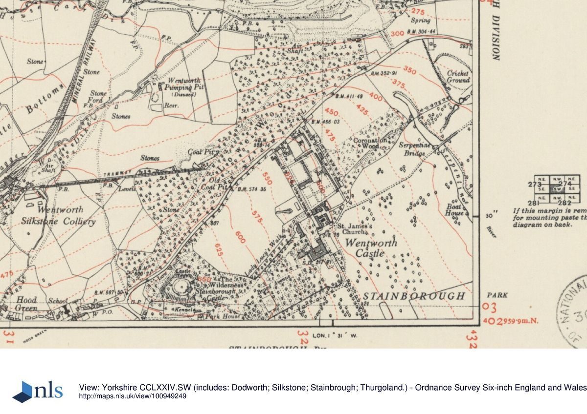
Wentworth Castle is situated c 3km south-west of Barnsley in an area which is predominantly rural and agricultural. The c 300ha site is on land which slopes gently downwards to the south and east. The boundary is formed by Lowe Lane to the north, where there is a wall and a steep bank. The south-west side of the side is bounded by Stainborough Lane as far as Cold Bath Farm, and from that point south-eastwards by fencing along the edges of fields and woodland. The south-east and east boundary is marked by fencing and walls along the edge of Wallside Plantation, Ivas Wood, Walker's Pond, and Menagerie Wood.
Entrances and Approaches
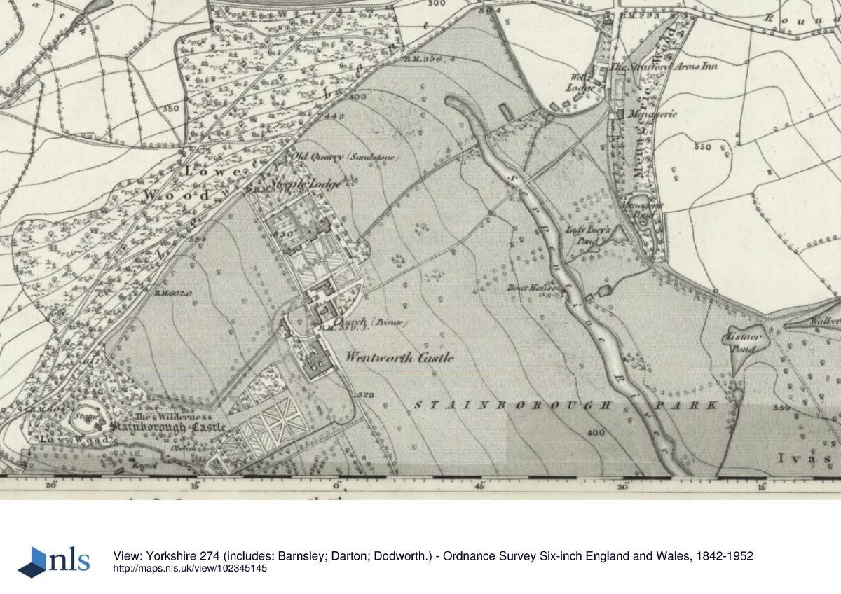
The principal entrance is on the north side of the site off Lowe Lane where there is a lodge called Steeple Lodge (c 1775, listed grade II). A drive leads south to Home Farm and to late C20 parking areas on the north side of the house. This approach is shown as an avenue on the north side of the public road (which ran on a line between the house and Home Farm until c 1720) on the Knyff and Kip engraving of 1714 and as a wider avenue on the Badeslade view, after the public road had been moved northwards to its present position.
The remains of an avenue aligned with the south front of the house extends for a distance of c 500m. This is on the same axis as the approach from Steeple Lodge and is shown on a c 1730 estate map and Badeslade's view but not on Knyff and Kip's 1714 engraving. This was the former principal approach from the south, shown on a county map of 1771, but the driveway is no longer discernible.
On the north-east side of the site there is an entrance with a stone pedimented arch (listed grade II) at the south end of Park Drive in the village of Stainborough. A drive, running on the line of the former public road, leads south-west as a causeway across meadow land and the Serpentine River via Serpentine Bridge (dated 1758, listed grade II), and on to the north side of the house.
A formal approach to the house from the east is shown on the 1714 engraving and on the c 1730 estate map, when there were entrance gates at the end of an avenue aligned with the east front. An entrance on the south-east side of the site at the end of a lane running west from Round Green Lane, opposite Round Green Lodge, has a lodge and an obelisk (1733, listed grade II) called Queen Anne's Obelisk from which a track runs north-westwards and joins with the drive from Stainborough.
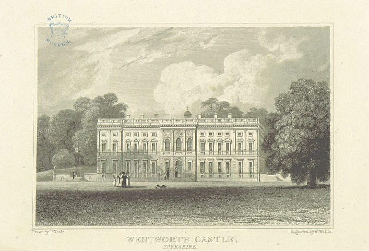
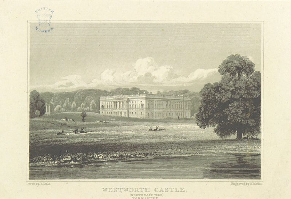
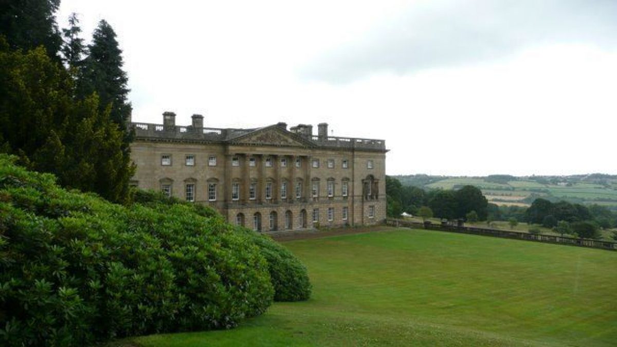
Principal Building
Wentworth Castle (listed grade I) was built for Sir Gervase Cutler 1670-2. The east wing was added 1710-20 by Johann Bodt for Thomas Wentworth, first Earl of Strafford, and the south front by his son William, to his own design. The building has had C20 alterations and additions in connection with its current use (1997) as a college, and a number of late C20 buildings lie to the north of the house. Immediately west of the house and connected to it by a glazed link is a conservatory (listed grade II*) of c 1840 constructed by F W T Vernon-Wentworth. The Home Farm is situated c 100m north-east of the house and consists of a complex of buildings including a stable block and barn of c 1715, altered or rebuilt mid C18 (all listed grade II), and a variety of other ancillary buildings of later C18 and C19 date (most of them listed grade II). The church of St James (c 1842, listed grade II) is situated on the north side of the open courtyard formed by the farm buildings.
Gardens and Pleasure Grounds
On the east front of the house there is a terrace with stone gate piers and ornate iron gates at the north and south ends (early C20, listed grade II). A lawn slopes down to the east and to a stone balustrade of early C20 date. Immediately east of this a beech hedge screens a late C20 car park. There are long-distance views from the terrace across parkland to agricultural land beyond. The Knyff and Kip engraving shows that a terrace on the east front of the house had central steps leading to a forecourt with a central octagonal pond which was aligned with the avenue approach from the east. This arrangement is also shown by Badeslade in 1739.
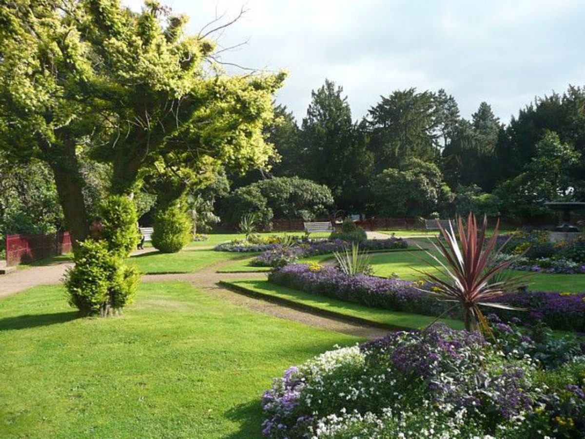
Steps lead up from the east terrace to a lawn on the south front of the house. A ha-ha (listed grade II) with a bow aligned with the front is situated c 100m south of the house and continues south-westwards along the edge of the pleasure grounds to a point c 600m south-west of the house where there is a scarp on the south and west side of Stainborough Castle (see below). The lawn below the south front rises to the west, overlooked by a temple (1739, listed grade II*) called the Corinthian Temple situated c 70m south-west of the house. Both the Knyff and Kip and the Badeslade engravings show the lawn laid out as a formal garden with shaped beds and statues. On the higher ground west of the Temple there is a terraced walk which runs north from the ha-ha for a distance of c 120m, overlooking the west side of the house and the conservatory.
Three routes lead south-westwards from this walk. At the south end a yew-lined path runs alongside the ha-ha. Parallel to this and c 80m to the north is Broad Avenue. A third route, called Lady Augusta's Walk, runs at the mid-point between these. This area is planted with a mixture of shrubs and mature trees, including cedars, yew and pines, and a system of grass paths radiates from Lady Augusta's Walk in a pattern shown on the Badeslade view and apparently maintained or periodically restored since that time. The framework of this part of the garden was established in 1713 when estate papers (quoted in Ray 1992) record the first Earl of Strafford initiating the laying out of two wildernesses in geometrical form on each side of a gravel path in a pattern which is probably reflected in the Knyff and Kip engraving.
North of Broad Avenue another avenue, called The Avenue or Lady Lucy's Walk, has as a terminus of the vista looking east, a building called the Gun Room (1732, listed grade II) which may have been a bath house. The Avenue, which was replanted C20 with limes, runs at an oblique angle to Broad Avenue, so that the two converge at a point c 200m south-west of the house. The Avenue is on the line of the former public road and it is shown as an avenue on the Badeslade view in 1739 by which date the road had been re-routed.
Lady Augusta's Walk leads to a hedged rectangular area called the Secret Garden c 200m south-west of the house which is entered via a stone archway with a viewing platform reached by stone steps. Opposite this, on the south side of the garden, there is a garden shelter which also has a viewing platform reached by stone steps. This garden has a central circular lawn and flower beds, and was laid out in approximately its present form with the entrance and shelter during the late C19. This area is not shown by Knyff and Kip, but it appears on the Badeslade view and on an estate map of c 1730 as a bowling green, which is referred to in estate papers and was constructed in 1719.
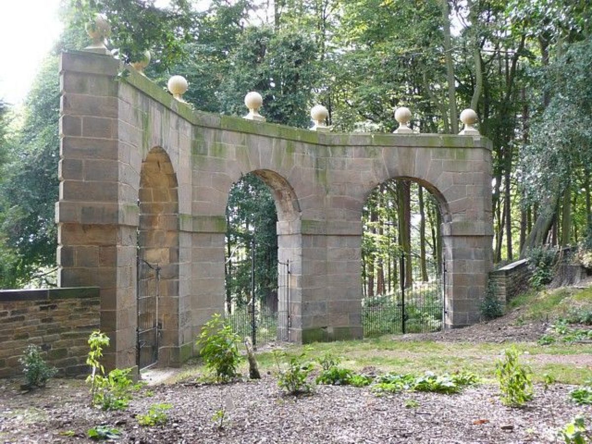
West of the Secret Garden there is a grassed clearing at the point at which the two avenues converge and on the south side of this there is a stone gateway (c 1738, listed grade II) with three arched openings, called Archer's Hill Gate. The ha-ha continues on the west side of this, from which point it has a crenellated stone parapet and changes direction to run west rather than south-west. At the southern edge of the clearing, c 300m south-west of the house, there is a stone obelisk (listed grade II) called the Sun Monument. This forms the terminus of the vistas along the avenues and was erected in 1747 by the second Earl in memory of Lady Mary Wortley Montague.
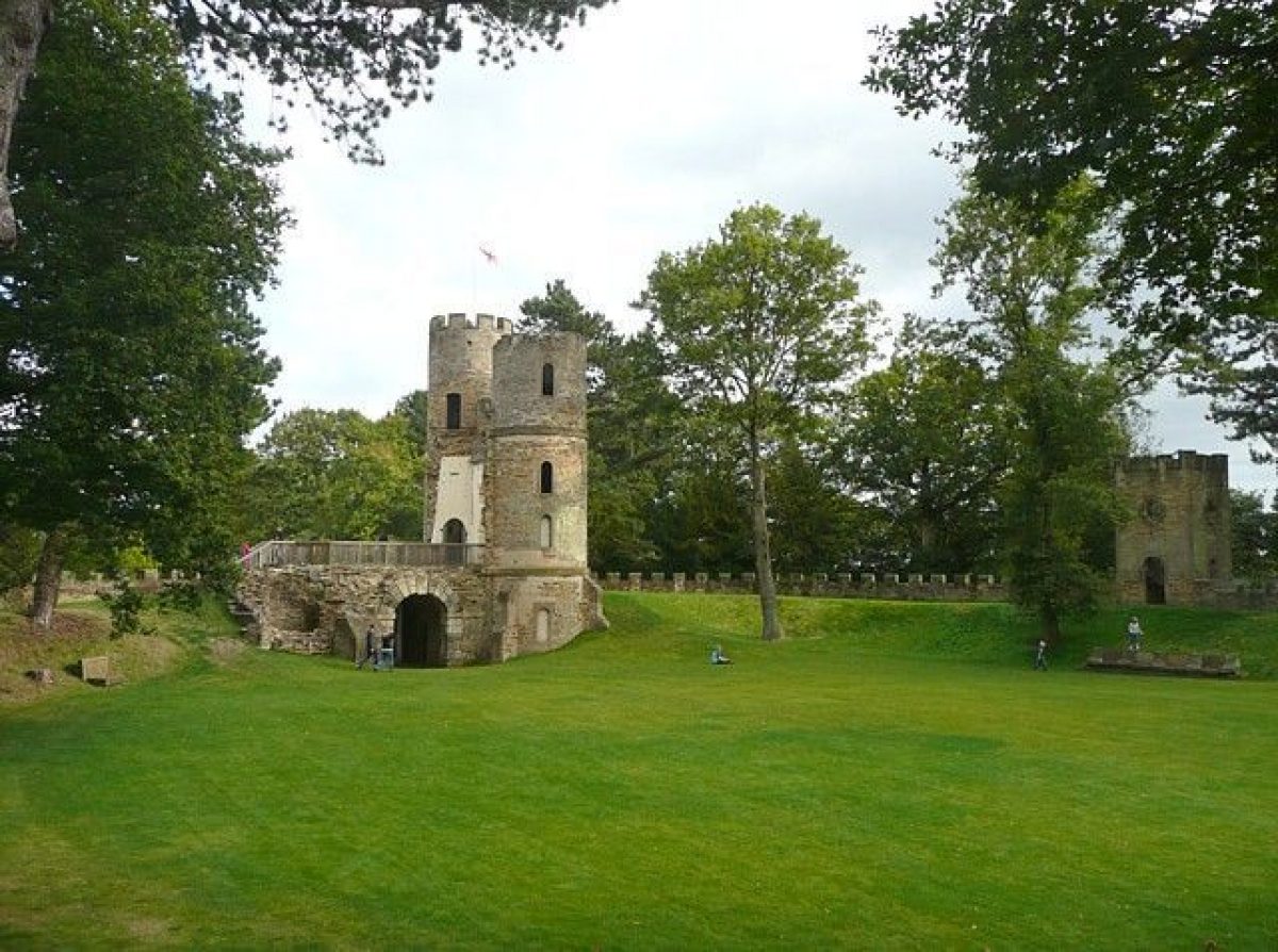
The axis of the garden changes at this point and the focus is to the west and a gothic folly called Stainborough Castle (listed grade II*) which stands, framed by trees, on the earthwork remains of what is thought to be an Iron Age fort (THAS 1991). The folly is a particularly early and ambitious example of a gothic mock castle which was erected c 1730 by the first Earl and is shown in the Badeslade view. Woods to the north, called The Wilderness on the 1890 OS map, are divided from parkland by a ha-ha which continues along the edge of The Avenue. The layout is much as shown by Badeslade, though at that time the Castle was approached by an avenue.
Park
Parkland surrounds the house and consists largely of pasture and land under arable cultivation. The east front of the house overlooks open parkland with scattered trees. The avenue approach from the east and Octagon Pond shown by Badeslade were removed by the second Earl c 1750 when he constructed the Serpentine River, c 500m east of the house, which is aligned approximately north/south and consists of a serpentine stone-lined watercourse, now (1997) partially dry. This is crossed by the Serpentine Bridge carrying the drive from the east entrance. Some 150m east of this is a crescent of woodland called Menagerie Wood on the inner edge of which, alongside the drive, is an early C18 building (listed grade II) called the Menagerie House which is shown on the Badeslade view and has been altered late C20. In the woods are the ruinous remains of a gothick folly, constructed in 1759 to the designs of Richard Bentley with advice from Horace Walpole. The Wood is shown with a series of lakes within it on the c 1730 map, where it is marked 'Manezery', and on the Badeslade view.
On the south-east side of the park, on the edge of Ivas Wood, there is a temple (listed grade II*) called the Rotunda which was erected in 1746 by the second Earl. Ivas Wood is shown on the c 1730 map and the Badeslade view with a pattern of drives radiating from the centre. On the south-west side of the park is a remnant of Broom Royd Wood, which was largely felled in the mid C20. The general shape of the wooded area as shown on the 1850 OS map is preserved in the pattern of field boundaries. The Wood is shown on the Knyff and Kip engraving with a geometrical pattern of rides cut through it, and on the c 1730 map and Badeslade view with a simpler pattern of rides. On the north side of the Wood, c 800m south-west of the house, is the Duke of Argyle's Monument (listed grade II*), a statue upon a column, which was erected by the second Earl in 1744. The parkland to the north and west of the monument is shown on the Knyff and Kip engraving as an enclosed deer park, and the area may have originated as Gervase Cutler's C17 deer park.
A complex system of avenues running over the park is shown by Badeslade, and was based around an axis orientated approximately north/south and east/west, which centred on the house. The c 1730 estate map shows a very similar arrangement of avenues. By 1771 these had been removed in the eastern part of the park (county map), while some vestigial avenues were evident in the western part of the park; these have now (1990s) largely disappeared.
Kitchen Garden
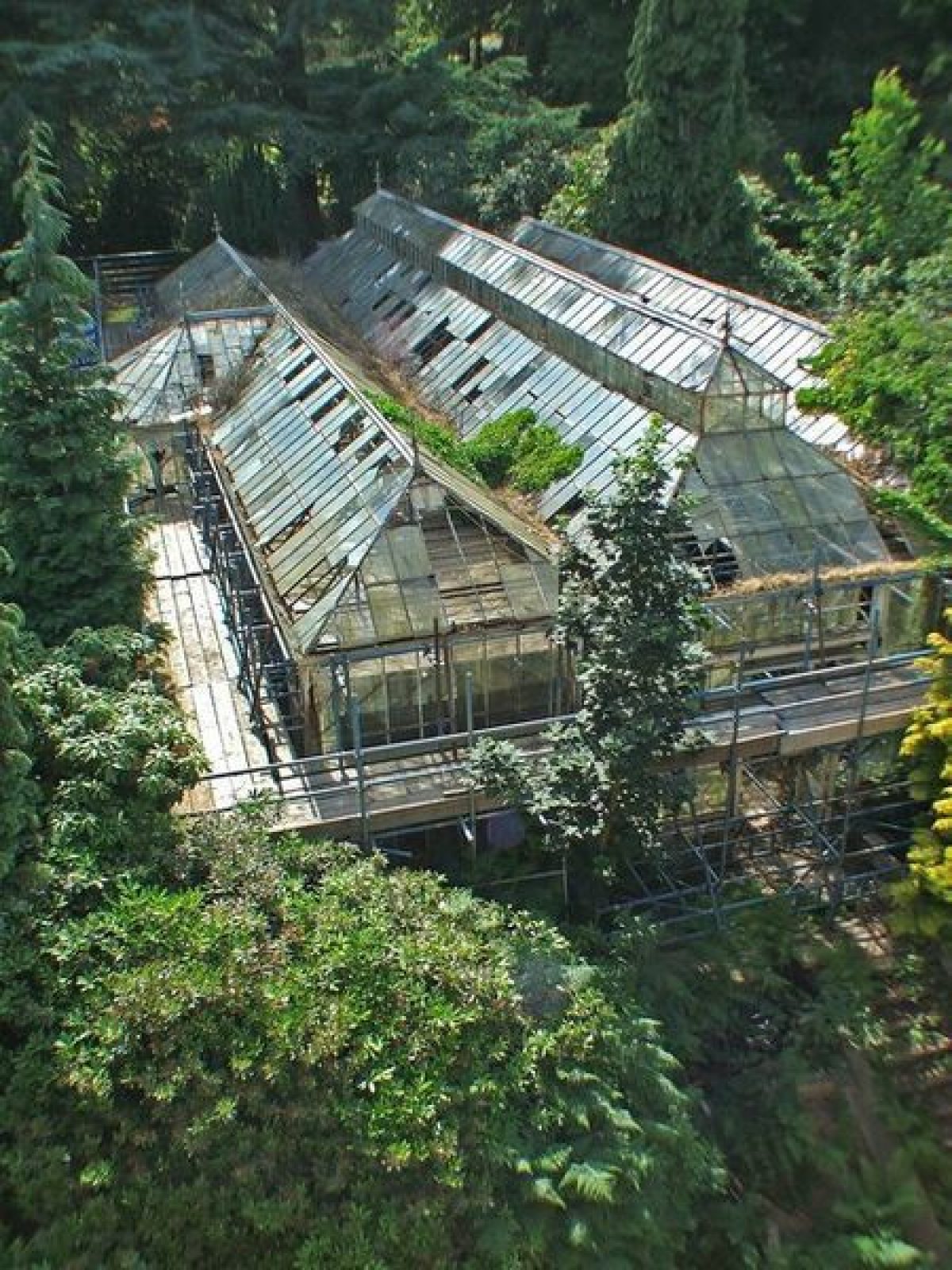
Kitchen gardens lie immediately north of Home Farm, on the east side of the main drive. They are on the site of a walled garden shown by both Knyff and Kip and Badeslade. Badeslade shows the orangery (c 1728, listed grade II) which is on the east side of the garden. The red-brick walls have been partially rebuilt late C20 and the garden has been used as a municipal nursery in the latter part of the C20, in connection with which there are a number of late C20 glasshouses.
REFERENCES
Country Life, 56 (18 October 1924), pp 588-96; (25 October 1924), pp 634-42
N Pevsner, The Buildings of England: Yorkshire The West Riding (1967), p 283
K Lemmon, The Gardens of Britain 5, (1978), pp 145-6
J E Humphrey, A Prospect of Stainborough, (MA thesis, Univ of Sheffield 1982)
A Proposal for Stainborough Park, (J Ray Associates 1990)
Trans Hunter Archaeol Soc (THAS) 16, (1991), pp 33-8
Restoration Scheme for Wentworth Castle and Stainborough Park, (J Ray Associates 1992)
Maps
A Map of the Manor of Stainborough ..., c 1730 [reproduced in Ray 1992]
T Jefferys, County Map, 1771
OS 6" to 1 mile: 1st edition published 1850
OS 25" to 1 mile: 1st edition published 1891
Archival items
For a summary of records held in Sheffield City Archives and the British Museum see Ray (1990).
Description written: November 1998
Register Inspector: CEH
Edited: November 1999
- Visitor Access, Directions & Contacts
Access contact details
The gardens are open daily from 10 am. Closing times are earlier in the winter. Please see: http://www.wentworthcastle.org...
Directions
The site is off junction 37 of the M1.
Owners
Wentworth Castle Trust
- History
The following is from the Register of Parks and Gardens of Special Historic Interest. For the most up-to-date Register entry, please visit the The National Heritage List for England (NHLE):
www.historicengland.org.uk/listing/the-list
HISTORIC DEVELOPMENT
The Everingham family settled at Stainborough c 1567. The estate was sold to the Cutler family in the mid C17 and sold again in 1708 to Thomas Wentworth. Wentworth wanted to impress a rival branch of the family, the Watson Wentworths at Wentworth Woodhouse (qv), and to press his claim to the title Earl of Strafford. The development of the house and grounds at Wentworth Castle has been seen as a demonstration of these ambitions and as an outlet for his energies following the end of his political career after the death of Queen Anne in 1714 (Ray 1990). The site at this date is illustrated in an engraving of 1714 by Knyff and Kip and by an aerial view of 1739 by Badeslade (both reproduced in Ray 1992). The gardens and parkland were altered and embellished by the second Earl of Strafford, Wentworth's son, who was a friend of Horace Walpole and may have been advised by him. Walpole, who described Wentworth Castle as 'my favourite of all great seats, such a variety of ground, of wood and water; almost all executed and disposed with so much taste' (quoted in Lemmon 1978), was certainly involved in the design of a gothic temple in the park. The estate remained in the family until 1802 when the Strafford title became extinct and continued in the ownership of the Vernon Wentworths who sold the house and gardens to Barnsley Council in 1948. During the mid C20 parts of the park were subject to opencast mining. The land was subsequently restored and returned to arable and pasture land, in which use it remains (1997). The house and gardens are currently (1997) in use as an adult education centre.
- Associated People
- Features & Designations
Designations
The National Heritage List for England: Register of Parks and Gardens
- Reference: GD1381
- Grade: I
The National Heritage List for England: Listed Building
- Reference: Wentworth Castle
- Grade: I
Features
- Temple
- Description: Corinthian temple.
- Planting
- Description: Azalea garden.
- Conservatory
- Walk
- Description: Lady Lucy's Walk.
- Parkland
- House
- Key Information
Type
Estate
Purpose
Ornamental
Principal Building
Education
Survival
Extant
Hectares
300
Open to the public
Yes
Civil Parish
Stainborough
- References
References
- {English Heritage Register of Parks and Gardens of Special Historic Interest}, (Swindon: English Heritage, 2008) [on CD-ROM] Historic England Register of Parks and Gardens of Special Historic Interest
- Pevsner, N., {The Buildings of England: Yorkshire The West Riding} (Harmondsworth: Penguin Books, 2nd edition 1967), p. 283 The Buildings of England: Yorkshire The West Riding
- Lemmon, K., {The Gardens of Britain 5: Yorkshire and Humberside} (London: Batsford, 1978), pp. 145-6 The Gardens of Britain 5: Yorkshire and Humberside
- Land Use Consultants {Wentworth Castle Gardens Conservation Management Plan} (2001) Wentworth Castle Gardens Conservation Management Plan
- Related Documents
-
CLS 1/1022
Conservation Plan - Hard Copy
Hilary Taylor Landscape Associates Ltd for Purcell Miller Tritton - 2005
-
CLS 1/1023
Woodland Management Plan - Hard Copy
Hilary Taylor Landscape Associates Ltd with Lowther Forestry Group - 2006
-
CLS 1/1024
Parkland Management Plan - Hard Copy
Hilary Taylor Landscape Associates Ltd - 2006
-
CLS 1/1025/1-6
Conservation Management Plan Vols 1 and 2; Phase 2 Appendices 1-8 (2 vols) - Hard Copy
Hilary Taylor Landscape Associates Ltd - 2007
-
CLS 1/1022