Introduction
The site originates in the early medieval period. The formal gardens were laid out in the 19th century, with adjacent lawns and woodland walks. There are also early-18th-century pleasure grounds and a small park. The site occupies an area of about 25 hectares.
Terrain
Much of the site lies on a plateau high above the Thames, with the western edge running along the steep scarp and cliffs above the river, down to the water itself, and the southern edge descending less steeply to Mill Lane.www.historicengland.org.uk/listing/the-list
Early C18 pleasure grounds and a small park, with C19 formal gardens, surrounding a mid C19 country house.
DESCRIPTION
LOCATION, AREA, BOUNDARIES, LANDFORM, SETTING
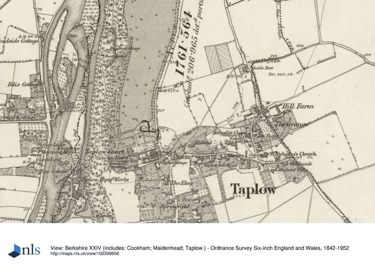
Taplow Court lies close to the eastern edge of Maidenhead, 5km west of Slough, forming the western boundary of the village of Taplow. The 25ha site is bounded to the west by the River Thames, to the north by Cliveden, to the east by Cliveden Road, and to the south largely by Mill Lane. Much of the site lies on a plateau high above the Thames, with the western edge running along the steep scarp and cliffs above the river, down to the water itself, and the southern edge descending less steeply to Mill Lane. The setting is agricultural to the north-east and south, with the designed landscapes of Cliveden to the north and Berry Hill to the south-east, the village of Taplow to the east, and Maidenhead prominent in the views down to the west and south-west.
ENTRANCES AND APPROACHES
The main entrance, from Taplow village, lies 100m east of the east, entrance front, off Cliveden Road, with a single-storey brick and half-timbered lodge to the north and brick gate piers with iron gates (C19, listed grade II) flanking the drive. The gravel drive runs straight, past flanking lawns edged by the brick walls of walled gardens on either side, opening out 50m from the house to encircle an oval lawn with, at the centre, a Coade stone statue (1804, listed grade II) of George III as a Roman emperor. The stable block forms the south boundary, and the north walled garden forms most of the north boundary of this entrance court which arrives at the portico on the east front of the house. A further short service drive enters 50m south of the main entrance, flanked, close to Cliveden Road, by red-brick gate piers to the churchyard (1799, listed grade II), giving access to the stable courtyard past the half-timbered former estate office (c 1890, listed grade II). This drive was formed from the old lane from the village to the site of the medieval parish church (now, 1997, gone), located close to the south front of the house. A further lodge lay at the south-west corner of the estate, adjacent to Mill Lane where there is now a pumping station (OS 1881-2). A drive along the riverside enters the estate at this point, giving access to the contiguous Cliveden estate to the north; the ground is so steep to the east all along the river that it is uncertain whether there was carriage access up to the Taplow plateau from this drive, although there was certainly pedestrian access.
PRINCIPAL BUILDING
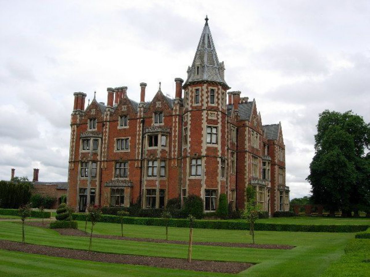
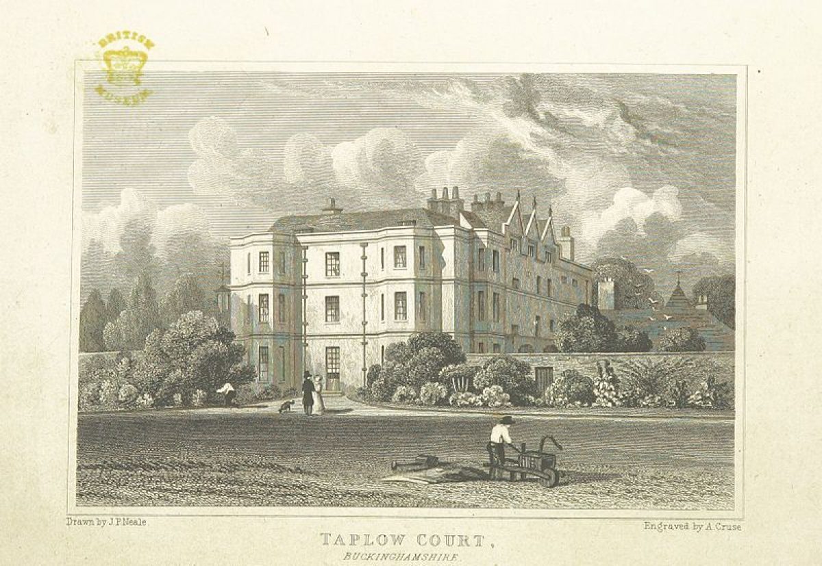
Taplow Court (William Burn 1855, listed grade II) lies towards the southern end of the site, surrounded by formal gardens except on the south side which is bounded by the site of the parish church and the churchyard. The red-brick Tudor-style house is on the site of the C17 manor house, possibly incorporating some of its fabric, and forms a compact rectangle attached, to the south-east, to the two-storey stable courtyard, also of red brick with some possibly C17 brickwork, entered from the north off the main entrance court and from the south off the old church lane/service drive.
GARDENS AND PLEASURE GROUNDS
The formal elements of the gardens lie close to the house, linked by straight gravel paths. Adjacent to the north front is a rectangular rose garden leading north to a former bowling green, now converted to a formal feature with a brick and wood pergola along the north axis and formal beds surrounding it, and to the north of this is a hard tennis court. West of the house, the formal west lawn, with gravel paths in a cruciform shape, and terracing, has long views towards Maidenhead, and through wrought-iron gates set in the red-brick churchyard wall (C17, listed grade II) into the churchyard which encloses the C7 burial mound, the site of the church (ruined by 1853 when it was cleared away), a churchyard cross of 1868 and several memorials and vaults. The garden path leads from the west lawn, around the churchyard, to the south, past the stone Grenfell memorial (B Mackennal 1920, listed grade II), and down to the small, ornamental, cruciform dairy (N J Cottingham c 1850, listed grade II), of brick and ashlar with elaborate wooden, gothic, gabled porches in the short arms. The panoramic views from the path running parallel with the south wall of the churchyard are spectacular, taking advantage of a spur of land, looking west towards and beyond Maidenhead and south and south-east across the Thames valley, taking in views of Windsor Castle (qv) and Eton College (qv) chapel. The foreground view south, down the gently sloping park, crosses Mill Lane to fields leading down to the river.
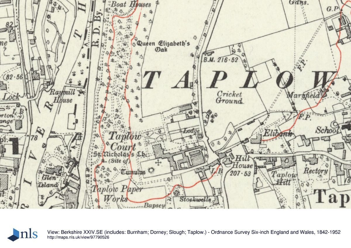
The pleasure grounds occupy the west side of the site, running north from the garden to the boundary with Cliveden. They are divided into two main, parallel sections: Cedar Walk, along the west edge of the plateau, which is bounded to the east by parkland; and the woodland on the steep scarp, including a quarried cliff, west of Cedar Walk dropping to the river. Cedar Walk is a grass ride flanked by an avenue of cedars, with Lebanon cedars predominantly at its southern end, seemingly dating from the C18, and, further north, younger cedars of different species, mostly dating from the early C20. The walk is probably of C18 origin, created by the first Lord Orkney. Many trees were lost during the 1990 storm, but enough remain such that the initial design intent is still evident. Various long views extend west from the walk, but these are much obscured by woodland growth. Several paths traverse the wooded hillside, leading down to the riverside paths and two boathouses (now gone) through woodland underplanted with shrubs such as Portuguese laurel, yew, box and holly. One of these paths runs along the top of a large quarry cliff past a pronounced mound planted with yews next to the site of a small ornamental building right at the edge of the cliff, 300m north of the house. This building is marked on the 1881(2 OS map as a Root House, but possibly stands on the site of an C18 semicircular colonnaded building (print held by SGI-UK); it was destroyed c 1950. The remains of an icehouse lie at the southern end of the woodland close to Mill Lane. A narrow island, Glen Island, lies along the west side of the estate, separated from it by the mill race which originally powered the paper mill at the south-west corner of the site, with the main stream of the river beyond.
PARK
The small park is divided into two sections, both pasture, with very few parkland trees. The southern section runs south from the churchyard down a gentle slope to the Mill Lane boundary, bounded on the west by the wooded pleasure grounds, with views south across to the pasture south of Mill Lane. The northern park lies on the plateau north of the gardens, bounded to the west by Cedar Walk and to the east by a narrow shelter belt of mixed species running along the Cliveden Road boundary and underplanted with evergreen shrubs. At the northern end is a cricket pitch.
KITCHEN GARDEN
There are three kitchen garden compartments. The northern walled garden, running parallel to the main drive, is surrounded by a restored C17 red-brick wall with three main gateways to the north, west and south with brick piers and wrought-iron gates. It was converted to a car park in the 1970s. South of the main drive a brick-walled garden, formerly containing glasshouse ranges, is filled by an office building constructed in the 1980s. South of the churchyard drive and stables, to the east of the dairy, is a third walled garden, surrounded by brick walls, which has been converted to an ornamental garden (c 1996).
REFERENCES
A guide to Taplow Court and its grounds, guidebook, (SGI-UK 1994)
N Pevsner and E Williamson, The Buildings of England: Buckinghamshire (1994), pp 690-2
Maps
Inclosure map for Taplow parish, 1787 (IR70), (Buckinghamshire Record Office)
Plan of the parish of Taplow, 1838 (MaR/37), (Buckinghamshire Record Office)
OS 6" to 1 mile: 1st edition published 1882
OS 25" to 1 mile:
1st edition published 1881-2
2nd edition published 1899
Description written: June 1997
Register Inspector: SR
Edited: September 2000
- Visitor Access, Directions & Contacts
Telephone
44 (0) 1628 773163Access contact details
The site is open on Sundays and Bank Holiday Mondays only, during the summer.
Directions
East of Maidenhead, immediately east of the A4094 on the west side of Taplow.
Owners
SGI-UK (a lay Buddhist society)
- History
The following is from the Register of Parks and Gardens of Special Historic Interest. For the most up-to-date Register entry, please visit the The National Heritage List for England (NHLE):
www.historicengland.org.uk/listing/the-list
HISTORIC DEVELOPMENT
The site has been in use since the Bronze Age. The burial mound of a Saxon lord was built on a promontory at the top of the scarp in the early C7, giving Taplow its name: Tappa's Mound (from Anglo-Saxon Taeppa's Hloew). George Hamilton, first Lord Orkney, bought the Taplow Court estate, together with the Cliveden estate (qv), c 1700, during his successful military career with the first Duke of Marlborough. Orkney seems to have lived mainly at Taplow rather than Cliveden, although the two estates were developed in tandem, particularly the hillside woodland walks which are contiguous. It is possible that Lancelot Brown (1716-83) worked here under the fifth Earl Inchiquin c 1776, although it is unclear what work, if any, was carried out (Cliveden guidebook, 1994). The Orkneys remodelled the C17 house several times, until in 1852 it was sold to Charles Pascoe Grenfell, who employed William Burn to remodel the house in its current Tudor style. During the late C19 Taplow Court became the focal point for the social group known as The Souls. During and following the Second World War the house was used for institutional purposes, being sold to Plessey Electronics in 1963, and bought by SGI-UK in 1988.
- Associated People
- Features & Designations
Designations
The National Heritage List for England: Register of Parks and Gardens
- Reference: GD1597
- Grade: II
Style
Formal
Features
- House (featured building)
- Description: William Burn remodelled the house in its current Tudor style.
- Earliest Date:
- Key Information
Type
Garden
Purpose
Ornamental
Principal Building
Religious Ritual And Funerary
Survival
Extant
Hectares
25
Open to the public
Yes
Civil Parish
Taplow
- References
References
- {English Heritage Register of Parks and Gardens of Special Historic Interest} (Swindon: English Heritage 2008) [on CD-ROM] Historic England Register of Parks and Gardens of Special Historic Interest
- Pevsner, N and Williamson, E {The Buildings of England: Buckinghamshire} (1994) pp 690-692 The Buildings of England: Buckinghamshire
- Related Documents
-
CLS 1/383/1
Landscape Restoration Management Plan - Digital copy
Elizabeth Banks Associates - 2000
-
CLS 1/383/1