
Introduction
Stoke Place is now a hotel and conference centre, lying within the Stoke Green conservation area.
www.historicengland.org.uk/listing/the-list
Summary of Garden
Mid-C18 pleasure ground by Lancelot ‘Capability' Brown as the setting for a late C17 Chiltern villa, extended in the mid-C18, for General Howard. A second major phase of development of the gardens followed in the early C19 by Howard's grandson with head gardener Mr Patrick, in which Brown's lake was enlarged, kitchen gardens erected, and features and parkland added to the east and south.
LOCATION, AREA, BOUNDARIES, LANDFORM, SETTING:
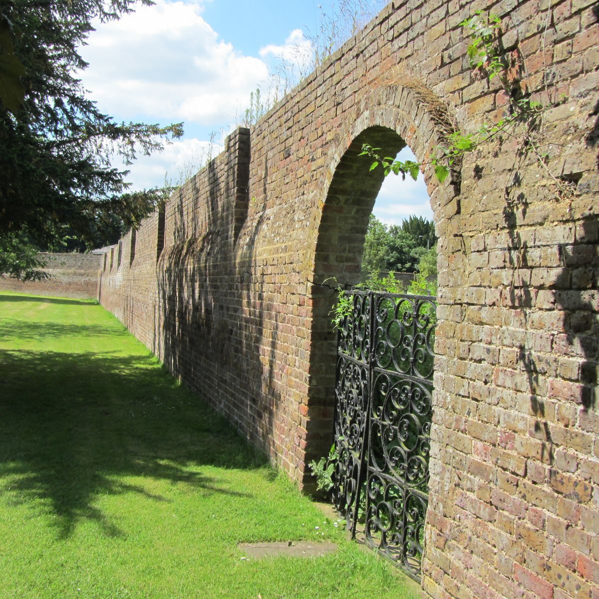
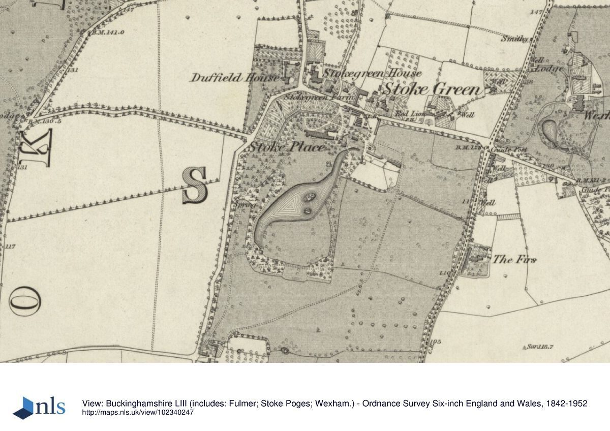
Stoke Poges parish is set on the dip slope of the Chiltern Hills in a predominantly wooded area which leads south towards the Thames at Eton and Windsor. The largely level 40 ha site lies 0.5 miles south-east of the parish church and Manor House. It is roughly rectangular, extending c700m north-south and 600m east-west, and slopes gently to the south-west of the lake below the dam. It is bounded to the west by Stoke Road, to the north by Stoke Green and to the east by Wexham Road. A red brick boundary wall (listed Grade II) encloses the north and west roadside boundaries for c500m alongside the pleasure grounds and kitchen garden, with the main, north gateway off Stoke Green. The site is bordered to the south by agricultural land.
ENTRANCES AND APPROACHES:
There were, by the mid- to late C19, three main drives. The principal one of these enters from the north, off Stoke Green, 100m north-east of the front door of the house. The gateway is set back from the road, flanked by curved and rendered wing walls adjoining the boundary walls (listed Grade II). Adjacent to the east, a pair of single-storey C19 brick cottages is hidden from the road by the boundary wall. From here the drive curves south-west to a turning circle in the forecourt to the north elevation of the house, enclosing a broad panel of lawn. The north side of the forecourt is enclosed by the walls to the kitchen gardens. This approach was created following the 1822 Inclosure when the long east-west strip of Stoke Green was acquired by Howard-Vyse, enabling him to extend the grounds by c90m as far north as the Stoke Green road.
The south-west drive enters off Stoke Road c650m south-west of the house, at Stoke Place Farm (C18 farmhouse, barn and cart shed listed Grade II). The disused north-facing gateway is set at right-angles to the road adjacent to the farmhouse and yard. C19 brick piers support tall wrought iron gates and overthrow (listed Grade II). From here the remains of the former south-west drive lead north through the park and into the pleasure grounds to the west of the lake, linking with the turning circle to the north of the house. The south-east drive originally entered through the farmyard at Stoke Place Farm, and led north-east through the park. The southern section survives as a track but no longer links through, as it did, to the east side of the forecourt between the former frame yard and pleasure ground. The south-east park drive had been created by Richard William Howard-Vyse by 1846 (parish map, PR 198/28/8/R) and the south-west drive by 1875 (OS).
PRINCIPAL BUILDING:
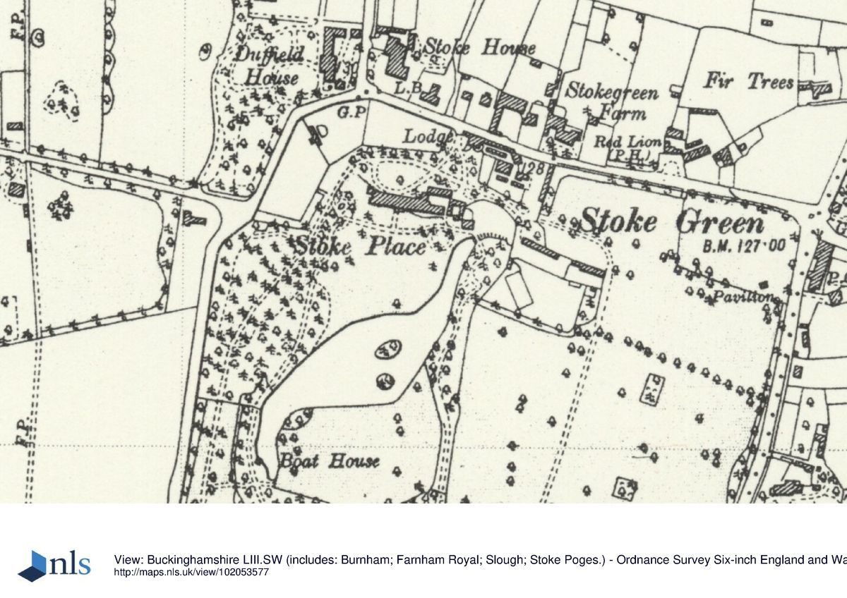
Stoke Place (listed Grade II) is a long, narrow country villa developed in a number of phases, incorporating Lambe's fine red brick 1690s central block and Howard's 1760s-70s wings. The long north entrance front overlooks the main drive and turning circle, and the garden front to the south overlooks a narrow terrace and informal lawns and a lake beyond, framed by trees. Formerly, a view extended further south over the park towards Windsor Castle (1818 Plan of Stoke Place D/121/11/3; late C19 OS), but southerly views are obscured by vegetation.
The service yards and buildings are adjacent to the east of the house with access via a spur off the main, north drive. These are now ancillary buildings to the hotel and include modern additions/replacements. The buildings and yards were screened by planting from the approaches and pleasure ground to the south, some of which survives including mature yew.
The stable yard and block were moved from the east end of the house in the early C19 to a yard 140m further east (1818 Plan of Stoke Place, D/121/11/3; 1846 Stoke Poges Parish plan, 198/28/8/R). The area now (2016) contains modern sheds.
GARDENS AND PLEASURE GROUNDS:
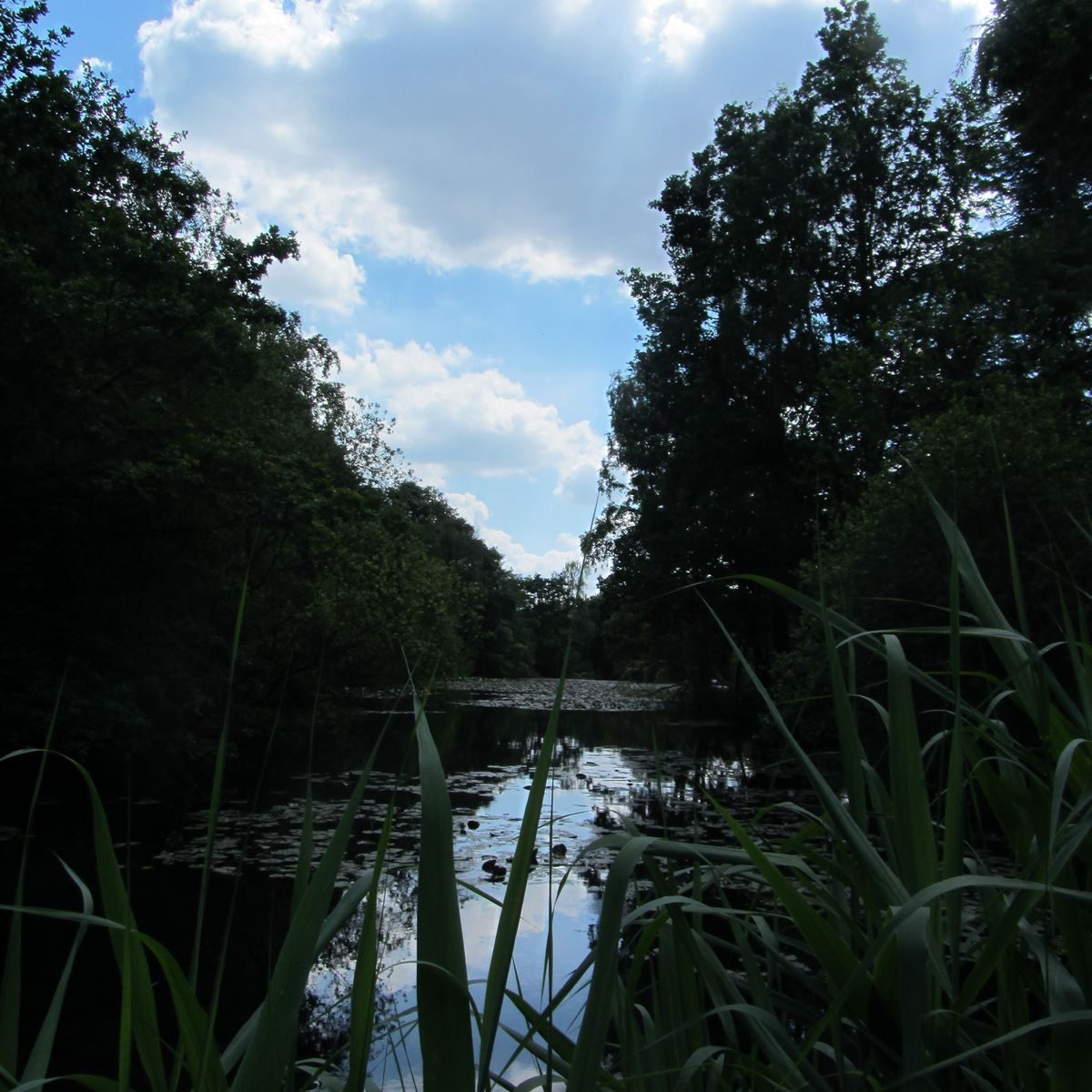
The 9 ha rectangle of gardens and pleasure grounds occupies the north-west quarter of the site. To the south of the house an informal lawn leads to the lake beyond, and forms the starting and finishing points for a circuit walk around the lake. A sinuous lake was formed by Brown in the 1760s and formed the centrepiece of the pleasure grounds. The lake was widened and the pleasure grounds were elaborated in the early C19 by head gardener Andrew Patrick for Howard-Vyse. Patrick's low mounds around the lake survive, with various trees including a fine common oak; nearby are a mature scarlet oak and two mature sweet chestnut, also a fine Atlantic cedar. The remains of a path cross the lawn west to east, 20m south of the house, linking the northern ends of the circuit walk.
To the west of the main lawn and south of the kitchen gardens a group of mature conifers form the remains of a pinetum, likely to date from the late C19. Directly in front of the south elevation of the house, a gravel terrace leads east towards the north end of the lake and a lawn enclosed to the north by a semi-circular red brick wall which divides the gardens from the former frame yard (now a car park) to the north. A pedestrian gateway at the centre of the curved wall is flanked by brick piers and contains a wrought iron gate with Howard-Vyse's initials (1820s). This east lawn formerly contained the free-standing Classical orangery shown in Gendall's 1820s view from the south shore of the lake (Rigby, 62).
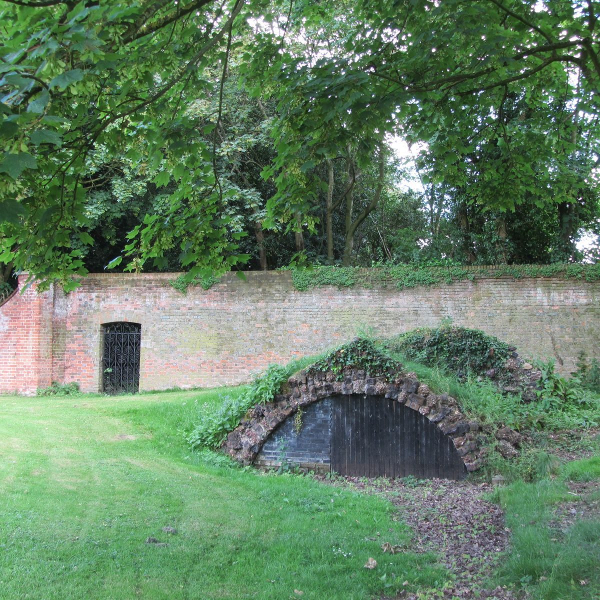
South of the lawn, the 350m-long lake is surrounded by a wooded walk; the path enjoys views over the water, pleasure grounds, and pasture, partially obscured by C20 tree growth. The path has been diverted, in places, from its original route. Various features punctuate the walk, beginning at the north tip, now dry, where there is a sunken boathouse (late C19) with a rustic masonry façade framing an arched opening. On the north-east side of the lake, 100m south-east of the house, is a mound planted with mature yew which was the position of the former rotunda (also shown in Gendall's 1820s view, and then on late C19 OS maps). There is a mound at the south-east corner of the pleasure ground, at the corner of the paddock, which late C19 OS maps show was the site of a substantial structure, the rubble remains of which are present. At the south tip of the lake are the ruinous remains of a larger, masonry boat house (1820s) within an artificial mound, its tunnel entrance leading to a partly sunken chamber. It is set back from the water, enclosed by mature yew, and the path passes in front of it alongside the water. The waterside footings of a second boathouse, first present on the 1925 OS, lie nearby to the north-west. On the west side of the lake the path leads along the flattened top of the dam, passing a C19 iron gateway and fencing with the lake outlet to the north. Here Patrick's 1820s rockwork channel with springs and planters leads to a pool, now dry.
PARK:
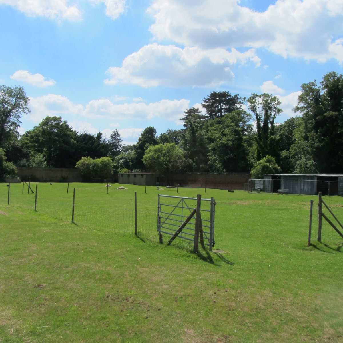
The park extends south and east of the pleasure ground and was added as the family acquired additional land to the south and east of the pleasure grounds. It remains largely pasture broken up by fences and hedges, planted with scattered mature trees and enclosed by a narrow belt around the roadside boundaries to west, north, and east. The north-east paddock remains a cricket pitch as it was by the early C20 (OS 1932) with associated later C20 buildings and car park in the north-west corner. Stoke Place Farm stands at the south-west corner of the park and formed a feature at the entrance to the two C19 park drives.
KITCHEN GARDEN:
The 1 ha kitchen gardens, built by Patrick in the 1820s, follow the curved boundary walls to the north-west of the house. They have high walls enclosing them on the south-east with cross walls forming three compartments, with an early-C19 gardener's cottage built into that between the two southern sections. The areas remain open and laid largely to grass. Ornamental wrought iron gates bear Howard-Vyse's initials.
To the east of the main drive lie the remains of a glasshouse and frame yard, also understood to date from the 1820s. It is enclosed to the north by the boundary wall along Stoke Green with a large fig growing against it and evidence of lean-to glasshouses, and a mushroom house surviving adjacent to the cottages. To the south it is bounded by the curved pleasure ground wall with a pedestrian gateway flanked by brick piers giving access to the east lawn and the site of the former orangery.Reasons for Designation
Stoke Place, a mid-C18 pleasure ground by Lancelot ‘Capability' Brown, developed and extended in the early C19 by head gardener Mr Patrick, is registered at Grade II, for the following principal reasons:
* Historic interest: as a mid-C18 pleasure ground, developed further in the early C19 with the addition of various landscape features, including a park and extensive kitchen gardens;
* Survival: retaining the general layout of the two main phases, both of which pre-date 1840;
* Designer: ‘Capability' Brown is one of the most important and influential figures in the history of English landscape design, and Stoke Place is an unusual example of a design by him for a pleasure ground in a villa setting;
* Historic association: General Sir George Howard and his grandson, Richard William Howard-Vyse, responsible for the two major phases of work at Stoke Place, are notable figures in C18 and C19 military and political history;
* Documentary evidence: early-C19 accounts provide an insight into gardening practices of the period, for which evidence on the ground survives;
* Group value: with Stoke Place house, two sets of gates and walls, and Stoke Place Farm, which once formed an entrance to the park, all of which are listed at Grade II.
Selected Sources
Books and journals
The Victoria History of the County of Buckingham, (1925), 302-313
Lipscomb, G, History and Antiquities of the County of Buckingham, (1847), 561
Penn, J, An Historical and Descriptive Account of Stoke Park in Buckinghamshire, (1813), 66
Pike (ed.), WT, Berkshire Buckinghamshire and Bedfordshire in the C20, Contemporary Biographies, (1907), 79
Rigby, L, Stoke Poges a Buckinghamshire Village, (2000), 60-64
Sheahan, J, History and Topography of Buckinghamshire, (1862), 871
Websites
Buckinghamshire Gardens Trust, ‘Stoke Place: Bucks Gardens Trust Research and Recording Project Site Dossier', 03 Nov. 2015, accessed 24/06/2016 from http://www.bucksgardenstrust.org.uk/wp-content/uploads/2016/02/Stoke_Place.pdf
John Phibbs, ‘Brown, Lancelot [Capability Brown] (bap. 1716, d. 1783)', Oxford Dictionary of National Biography, online edn, April 2016, accessed 19/07/2016 from http://www.oxforddnb.com/view/article/3635
Jonathan Spain, ‘Howard, Sir George (bap. 1718, d. 1796)', Oxford Dictionary of National Biography, online edn, May 2009, accessed 21/06/2016 from http://www.oxforddnb.com/view/article/13900
Other
1760s, Jefferys, Map of Buckinghamshire (CBS)
1813, Road Diversion Plan (CBS Q/H/38)
1814, Plans of grounds to north and west of Stoke Place house by ‘WA' [?William Atkinson] (CBS D121/11)
1817, Road Diversion Plan (CBS Q/H/46)
1818, Plan of Stoke Place, R Binfield (CBS D121/11/3)
1822, Inclosure Map, Stoke Poges and Wexham (CBS IR138 Q)
1822, Stoke Place, parcel of land acquired for new kitchen garden (CBS D121/10)
1824, Bryant, Map of Buckinghamshire
1824, Stoke Poges (CBS Ma/198/I.R.)
1825, Stoke Place, parcel of land acquired for new kitchen garden (in deed margin) (CBS D-HV/A/94)
1846, Stoke Poges Parish (CBS PR 198/28/2/R)
Ackerman, Repository of Arts (1826) [view by John Gendall]
Buckinghamshire County Council: Photograph 1933, garden by south front of house phStokePoges52
c.1814, Plans of proposed alterations to Stoke Place house by ‘WA' [?William Atkinson] (CBS D121/12)
D-HV 1642-1812 Howard-Vyse Collection Deeds relating to properties in Stoke Poges, Bucks and papers relating to the Howard and Vyse families. Centre for Bucks Studies, Aylesbury
D-HV/A Deeds, Centre for Bucks Studies, Aylesbury:Mid-late C17 sales of land, main sale Boon Jordans from Richard Windsor to Wm Astley, then Astley to Patrick Lambe who built core of Stoke Place house, D-HV/A 1, 2, 3, 5, 6, 7, 9, 10, 15, 16. Early- mid-C18 sales of land, Patrick Lambe's son to Dame Frances Stapleton, then to her son Sir Thos, then to Hannah Sedgly, D-HV/A 17, 18, 22, 23, 24, 28, 35, 36, 40, 41, 42, 43. 1764 Sale of estate, Hannah Sedgly to George Howard, D-HV/A/44, 47. Late C18 land acquisitions by Howard, D-HV/A/48, 50, 52, 87 (abstract of title, George Howard). Relevant early-mid-C19 deeds, etc, D-HV/A/87, 94, 95, 106, 109.
D-HV/C Deeds for properties beyond Bucks, and other material, Centre for Bucks Studies, Aylesbury: D-HV/C/3 Marriage apportionment to George Howard 1749. D/121 includes further early deeds for various parcels of land: D 121/77, 79, 81, 82, 88 (1657-1723). D/121/10/1 Correspondence: Sir George Howard got Mr Penn Lord of the Manor to rail off that part of Stoke Green in front of the house, i.e. Stoke Place (1764-96).
Gardener's Magazine, vol 9 (1833), 525-28; (January 1835), and 12-13; (1834)
Knight's Tourist's Companion Through the Land We Live In (1853), 22-23
Lincoln, Rutland & Stamford Mercury (31 Oct 1788), 3. [visit by the royal family]
Ordnance Survey 6" & 25" to 1 mile, 1st edition surveyed 1875; 2nd edition surveyed 1897; 3rd edition surveyed 1923/24;
1938 revision.
1: 2,500 scale, published 1971.
Ordnance Surveyor's Drawing (OSD), sh. 153, 1811-12 (British Library)
The Times: 01 November 1793, 2. [visit by their majesties during the course of an airing]; 07 September 1793, 2. [visit by their majesties and the princesses]; 11 October 1793, 2. [visit by their majesties and the princesses]; 11 October 1793, 2. [visit by their majesties and the princesses]; 17 March 1789, 2. [visit by George III on horseback].
Wright's Leeds Intelligencer (26 November 1810), 3. [marriage of RW Howard-Vyse in Chester]
- Visitor Access, Directions & Contacts
Telephone
01753 534790Website
https://www.stokeplace.co.ukAccess contact details
The site is now a hotel.
Directions
http://www.stokeplace.co.uk/location
Owners
South Bucks District Council
Capswood, Oxford Road, Denham, UB9 4LH
- History
The following is from the Register of Parks and Gardens of Special Historic Interest. For the most up-to-date Register entry, please visit the The National Heritage List for England (NHLE):
www.historicengland.org.uk/listing/the-list
History
Records of the sale of a property at Stoke Place begin in 1668, and the central portion of the existing villa is likely to have originated in the 1690s, as part of a phase of development by Patrick Lambe. Gardens are known to have existed at this time, and geometric parch marks on the south lawn of the house indicate a formal arrangement.
Stoke Place was sold in 1764 to career soldier George Howard. Howard was renowned: a veteran of the Seven Years' War and other campaigns with the Royal East Kent Regiment, and had also fought at Fountenoy, Falkirk and Culloden. He was equerry to Queen Charlotte and was well-liked by the King, who visited Stoke Place a number of times whilst staying at Windsor. He was made Lieutenant-General in 1760, General in 1777, and Field Marshal in 1793; he was knighted in 1774.
The deeds of sale record the ‘capital messuage built by Patrick Lambe', courtyards and gardens, various parcels of land, a farmhouse, barn, other buildings to the west of the house, and a ha-ha and water source. Howard began improving the house and garden from the outset. He employed the foremost landscape designer of the time, Lancelot ‘Capability' Brown to lay out an informal lake and pleasure grounds near the house, and is believed to have employed the architect Stiff Ledbetter to extend the house (Colvin, 604).
Brown (1716-83) was England's leading and most influential landscape designer of the mid to late C18. His first employment as gardener was at his birthplace of Kirkharle (Northumberland), where his duties extended to laying out the grounds. In the late 1730s he began to work on improving parks elsewhere, and by 1741 his reputation was such that he was taken on as head gardener, clerk of works and paymaster for Lord Cobham at Stowe (Bucks). Here he was exposed to the work of William Kent and James Gibbs. From 1745 he worked on successive major commissions, at first mainly in the midlands, then further afield, designing houses as well as transforming landscapes. In 1764 he was appointed Master Gardener at Hampton Court, and in 1765 as his practice expanded still further he took on various assistants, several of whom became well-known designers in their own right. At the peak of his success, in the 1760s and 1770s, he had an annual turnover of £15,000 (around £1m today), and overall worked on well over 200 estates. He died, suddenly, in 1783.
Developing on a much grander scale the idea of the naturalistic landscape promoted by William Kent (c.1685-1748), Brown's signature features - ‘Capability' referring to his ability to realize the capabilities, that is the inherent possibilities, of landscapes - included gently rolling parkland (separated from the house by a ha-ha), clumps of trees, a sinuous lake in the middle distance (typically contrived by damming a river or stream) and shelter belts around the park edge screening the world beyond. His ideas were generally conveyed through site visits, a large site plan and by staking out, and unlike Humphry Repton, his successor, he left no writings, theoretical or practical, which set out his vision or working methods. But it is clear that by large-scale yet subtle earth moving, drainage and water management and by planting, Brown was able to create landscapes that were pleasing to the eye, with often subtle yet very successfully controlled views both within the park, and outward from it. There is still much to learn, however, about his achievements, both in terms of individual sites and about his working methods.
Brown's account books record payments by Howard of £200, £400 and £200, in June 1765, March 1766 and May 1767, a typical pattern over a number of seasons.
Howard died in 1796 and the estate passed to his grandson, Richard William Howard-Vyse, an army officer, MP, and Egyptologist, who lived at Stoke Place for almost 60 years, and in the 1810s-1820s made developments to the landscape. Inclosure in 1822 unlocked the surrounding land, parcels of which were acquired and turned to parkland. Grays Road was moved westward, in two phases, and the kitchen gardens and forecourt also date from this period.
Head gardener Andrew Patrick's works in the grounds during the 1820s were reported upon favourably in JC Loudon's popular Gardener's Magazine. In 1833 it was reported that Patrick enlarged Brown's water and used the spoil to undulate the ground, including earthing-up trees to create mounds. Pudding stone was used to create a rockwork feature at the lake edge, with planters and springs. The kitchen gardens and gardener's cottage, enclosed by c4m high walls, were built in 1825. There were many garden ornaments, now lost, images of some of which he published in 1835. Lipscomb noted in 1847 how the pleasure grounds on the south front were ‘enlivened by a sheet of water' and that on the lawn stood some ‘very remarkable cedars', a species which grew well in the area.
There were two key ornamental structures, the orangery and rotunda, possibly the work of Brown, which were present in Gendall's view of 1826. The orangery suffered bomb damage in the Second World War and its remains have been cleared. The rotunda has also been lost, though there are rubble remains on its mound on the north-east side of the lake. The paths on this mound are shown on the late C19 Ordnance Survey but have since been lost. The remains of a third structure, possibly a summerhouse, can be found on the mound to the south-east of the lake. The drives leading from Stoke Place Farm have been abandoned though are still discernible at points.
Richard William died in 1853 and Stoke Place was inherited by a succession of fathers and sons, all of whom continued the military tradition. The Ordnance Survey of 1875 shows the landscape design at its most extensive. The northern boathouse and the pinetum are likely to date from around this time. By the 1930s the areas near the house contained various horticultural features in Victorian style, including intricate circular ‘basket beds' scattered on the lawn below the terrace (photograph, 1933). In 1962 the last family owner, Major General Sir Richard Howard-Vyse, died. The property was purchased by South Bucks District Council and it became a nursing home and then, in the 1990s, a hotel, in which use it remains.
Period
18th Century (1701 to 1800)
- Associated People
- Features & Designations
Designations
Conservation Area
- Reference: Stoke Green Conservation Area
The National Heritage List for England: Register of Parks and Gardens
- Reference: 1436431
- Grade: II
Features
- Country House (featured building)
- Earliest Date:
- Latest Date:
- Boundary Wall
- Description: C18 red brick with C19 buttressed top section. 10/11 ft high. Semicircular entrance with stuccoed walls and brick piers.
- Icehouse
- Lake
- Key Information
Type
Park
Purpose
Ornamental
Principal Building
Commercial
Period
18th Century (1701 to 1800)
Survival
Extant
Open to the public
Yes
Civil Parish
Stoke Poges
- References
References
- Phibbs, J. {A list of landscapes that have been attributed to Lancelot ‘ Capability’ Brown} (Garden History 41: 2, 2013) 244-77) A list of landscapes that have been attributed to Lancelot ‘Capability’ Brown
- http://www.bucksgardenstrust.org.uk/wp-content/uploads/2016/02/Stoke_Place.pdf Understanding Historic Parks and Gardens in Buckinghamshire
Contributors
Jenifer White