Introduction
Laid out originally around 1760 and further developed through the 19th century, the formal gardens and woodland lie within a park and larger agricultural estate. At its most extensive the estate covered around 320 hectares. The surviving gardens, lakes and woodland are now within a public park of about 23 hectares, and the house is an Arts Centre.
Terrain
The land slopes down from a low hillside at the north tip to level out across much of the rest of the park, with a further low rise along the southern half of the east boundary.The following is from the Register of Parks and Gardens of Special Historic Interest. For the most up-to-date Register entry, please visit the The National Heritage List for England (NHLE):
www.historicengland.org.uk/listing/the-list
A country house and formal mid to late C19 terraced gardens surrounded by wooded pleasure grounds and severely truncated remains of C18 parkland, now a public park.
Location, Area, Boundaries, Landform and Setting
South Hill Park lies 2km south of Bracknell, engulfed within the southern suburb of Birch Hill. The 23ha site is bounded by mid to late C20 housing and associated development, with elements of the former parkland planting, particularly mature specimen Lebanon cedars, absorbed within the associated landscaping. The land slopes down from a low hillside at the north tip to level out across much of the rest of the park, with a further low rise along the southern half of the east boundary, on which part of the pleasure grounds are situated. The immediate setting is suburban, with the remains of impressive former parkland trees visible, scattered through the closest development. Beyond the C20 development to the south lies Bracknell Forest, visible in views from the raised ground at the northern tip of the park as it rises on a low hillside.
Entrances and Approaches
The main approach is via Ringmead, a C20 estate road which bisects the park west to east 40m north of the house. A drive off Ringmead 50m north-west of the house leads east through a car park to the forecourt adjacent to the north, entrance front of the house. A brick and stone balustraded wall runs parallel with the car park along its south side, connected to the north-west corner of the forecourt walls.
The entrance to the forecourt, on the north side, is marked by tall stone gate piers flanked by stone balustrading standing on brick walls. A further pair of piers flank a pedestrian gateway at the east end of the north wall, with a third pair of stone piers set into the west wall of the forecourt giving access to the former course of the west drive, passing north of the service court at the west end of the house. The east side of the forecourt is bounded by a theatre in modern idiom (1984). A flight of steps with brick and stone balustrade rises south from the entrance to the theatre towards the house, to the level of a brick wall forming the north boundary of the knot garden lying east of the house, from where a raised walkway runs east along the north side of the wall, overlooking the gardens and pleasure grounds.
Formerly (OS 1876; 1912), main drives approached from the north-west and east, their entrances marked by lodges. That from the north-west crossed the northern parkland to approach the house from the west, flanked by an avenue of conifers which led to the west gateway into the forecourt. The east drive passed through woodland, turning north along the east side of the pleasure grounds to enter the forecourt from the east side.
Principal Building
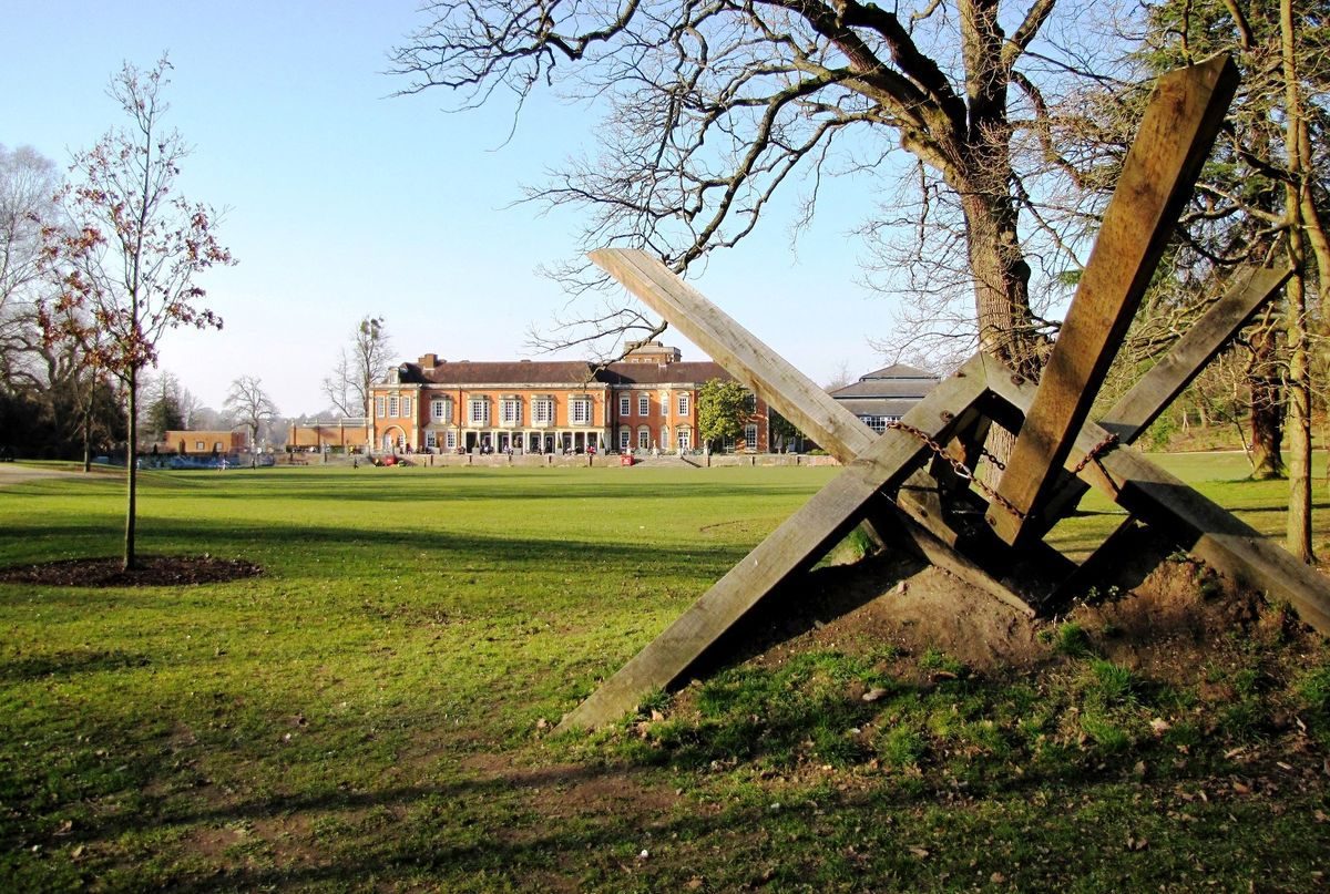
South Hill Park (1760, Temple Moore 1890s, listed grade II) stands towards the centre of the park and pleasure grounds, surrounded by terraced gardens to the south and east. The two-storey, formerly stuccoed C18 house was extended and remodelled by Temple Moore (1891-8) who refaced it in brick with Bath stone dressings. A service court attached to the west front is surrounded by tall brick walls embellished with stone urns placed on the stone coping, the north wall screening the court from the west approach to the house and the south wall forming part of the garden structure adjacent to the south terrace. The court is approached from a short drive to the west which was formerly reached via a spur off the main west drive. Within the court low, lean-to brick service buildings stand adjacent to the north and south walls.
Gardens and Pleasure Grounds
Formal terraced gardens surround the house to the south and east, these being flanked by wooded pleasure grounds which run south, meeting at a long, narrow lake.
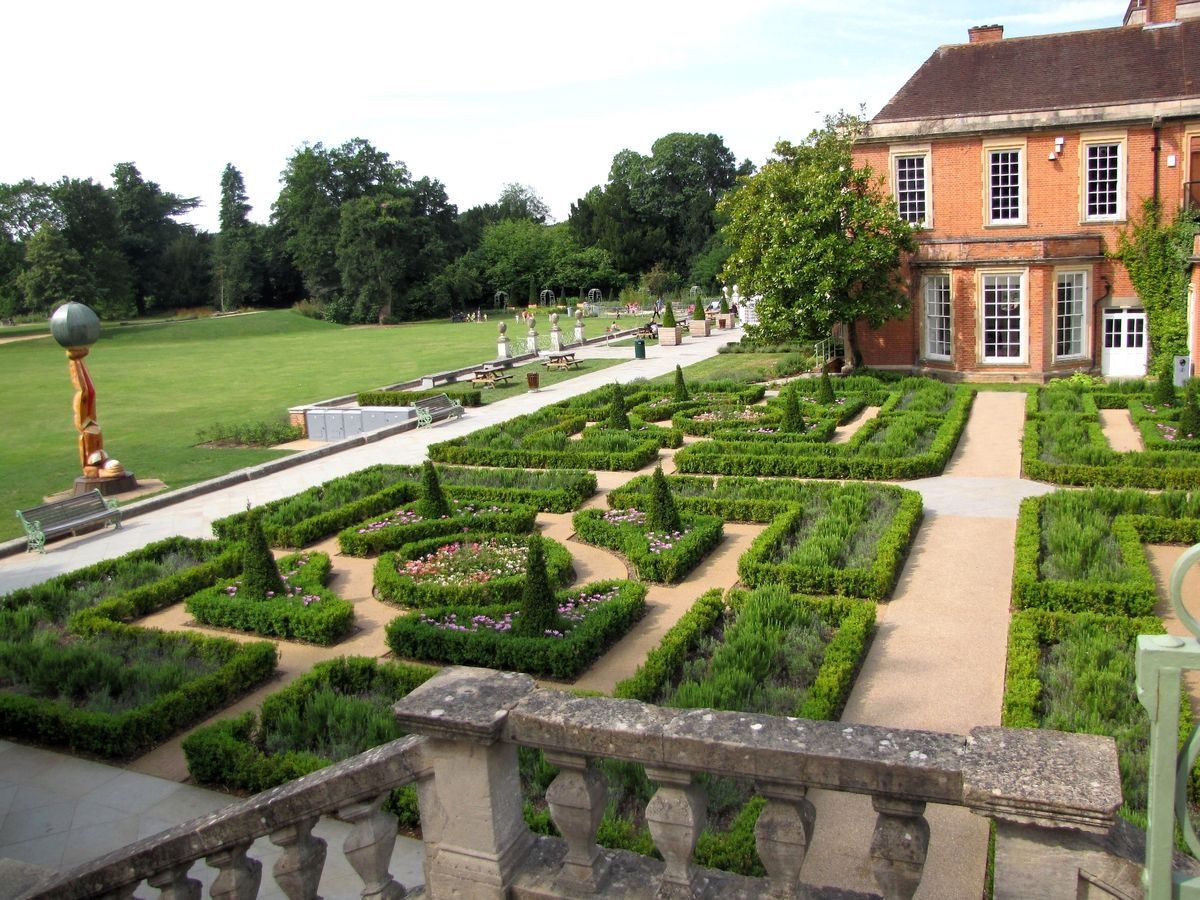
The formal terrace gardens are reached from the south front of the house, along which runs a long raised terrace, laid to paving adjacent to the house. Beyond the paving lies a lawn extending to the south boundary of the terrace, which is broken in two places in front of the house by flights of broad stone steps leading down to an informal lawn beyond. The top of each flight of steps is flanked by two pairs of stone piers linked in places by the remains of iron screen panels. At the west end of the terrace a further flight of stone steps leads down to the square Rose Garden, enclosed by clipped yew hedges to north, west and south and divided by gravel paths in cruciform pattern into quarters which are laid to lawn panels with central circular rose beds. An iron gateway marks the entrance from the pleasure grounds to the west, with the north path leading to the west, entrance side of the service court. The south entrance leads to Yew Tree Walk, a gravel path flanked by specimen Irish yews (Taxus baccata `Fastigiata¿) set in lawn, running south towards the north end of the lake.
The south terrace continues east beyond the east end of the house, the terrace wall from this point being stepped north, so that it runs along the south side of the paved path. To the north of the path, extending from the east front which contains a projecting garden room at its north end, the terrace opens out into a square parterre containing a box-hedged knot garden crossed centrally by two paths set in cruciform pattern. The parterre is bounded on the north side by a high brick wall with stone coping on which stand several stone urns, and is overlooked by the 1980s theatre. T
he east end of the south terrace is terminated by a raised, brick terrace wall enclosing an arched brick recess, with stone dressing around the arch, containing a stone seat. The east side of the parterre is bounded by the brick terrace wall extending north from the brick recess. Towards the centre of this wall, aligned on the central parterre path to the west, stands a stone-balustraded double staircase. This encloses a further arched recess containing a rectangular stone trough behind a semicircular pond at ground level which projects into the adjacent gravel path. The staircase rises to an open lawn, enclosed by 1m high clipped yew hedges, set in part of the east arm of the wooded pleasure grounds. A marble basin, formerly a pond with a fountain (OS 1912) and now a flower bed, stands at the centre of the main area of lawn, in line with the staircase and central parterre path to the west. The lawn narrows to the east, with an iron gateway on the south boundary giving access to the pleasure grounds.
The two arms of the pleasure grounds extend south, enclosing a level, open lawn which connects the south terrace and house with the lake to the south. The pleasure grounds, containing informal paths and many exotic trees, extend south either side of the lake, the eastern arm giving access to the former walled garden to the south. The southern end of the lake is surrounded by a raised bank in which is set the remains of a small cascade, via which the lake was formerly fed by a small stream running south to north.
The main structure of the terraces and pleasure grounds was in place by the late C19 (OS 1876). At this time the south and east terraces were supported by informal earth banks, with a tree planted in the centre of what became the parterre. A further, shorter lake extended north from the present southern lake, the two separated by a bank, passing close to the west end of the house. By 1912 (OS) this had disappeared, replaced by the Yew Walk and the formal rose garden to the north, with the formal terraces constructed as seen now (1998), including a small water feature lying at the east end of the south terrace on the lower lawn, where the terrace wall steps back to the north.
Park
The park encloses the house and pleasure grounds to the north and west and is laid to lawn, being dominated by the long, narrow lake lying north of the house, and bisected west to east by an estate road, Ringmead. The park slopes down from a wooded hillside at the north tip, opening out into lawn surrounding the lake, with the remains of a further lake, now a boggy depression, extending west from the north end of the lake. Views extend south from the hillside at the north end to distant low, wooded hills. Specimen cedars of Lebanon are scattered between low-level housing rising up the hillside to the east. The largely level southern section of the park, south of Ringmead road and west of the house and pleasure grounds, contains a substantial car park at the northern end, with a large, C20, grassed earth bank extending south from this. The area contains several notable specimen trees, including cedars of Lebanon.
In the mid C18 (Rocque, 1761) the estate, extending further west and east than at present (1998), was known as South Hill. The lake north of the house was present, shorter in form at that time, bounded to the west by an avenue leading north from the house to the low hillside at the northern tip of the park. By the late C18 (Pride, 1790) the estate was known as Southill Lodge, by which time a string of lakes had been created, progressing through the pleasure grounds and park, which contained many parkland trees. This formed the basis of the C19 and early to mid C20 landscape, until in the 1970s-80s the suburb of Birch Hill enclosed the park, taking in substantial areas of parkland to west and east.
Kitchen Garden
The brick-walled former kitchen garden lies outside the registered area at the southern end of the site. It now (1998) contains a late C20, intensive housing development.
REFERENCES
Victoria History of the County of Berkshire 3, (1923), pp 77-9
N Pevsner, The Buildings of England: Berkshire (1966), p 96
South Hill Park, a Brief History and Introduction to the Tree Trail, guidebook, (Bracknell Forest Countryside Service 1997)
G Brandwood, Temple Moore (1997), pp 162-3
Maps
J Rocque, Map of Berkshire, 1761
T Pride, A topographical map of the Town of Reading and the County adjacent to an extent of 10 miles, 1790
OS 6" to 1 mile:
1st edition published 1876
2nd edition published 1913
OS 25" to 1 mile: 2nd edition published 1912
Description written: September 1998
Register Inspector: SR
Edited: April 2000
- Visitor Access, Directions & Contacts
Telephone
44 (0)1344 484 123Website
https://www.southhillpark.org.ukAccess contact details
The site is now an Arts Centre.
Directions
Just outside Bracknell off the A322 Bagshot Road.
- History
The following is from the Register of Parks and Gardens of Special Historic Interest. For the most up-to-date Register entry, please visit the The National Heritage List for England (NHLE):
www.historicengland.org.uk/listing/the-list
HISTORIC DEVELOPMENT
South Hill Park was built in 1760 for William Watts, for his retirement from his post as a senior officer in the Bengal government. At this time the estate appears to have consisted of hedged parkland containing three buildings grouped close to the centre of the park, probably on or close to the site of the present house, and an elongated pond to the north, marked as Fisher¿s Lodge (Rocque, 1761). A stream bisected the centre of the park south to north. Upon Watts' death in 1764 the estate was sold to Henry Bouverie, and in 1787 to Sir Stephen Lushington. By the late C18 (Pride, 1790) the enclosed park was known as Southill Lodge, and contained many park trees, a walled garden on the south boundary and two long, narrow lakes which bisected the park south to north, with the house close by to the east.
The former Prime Minister and Chancellor of the Exchequer George Canning bought the estate in 1807, it being sold to the earls of Limerick in 1827 and then in 1847 to Sir James Matheson who sold it to Sir William Hayter in 1853. In the late C19 Sir William's son, Sir Arthur Divett Hayter, created Lord Haversham in 1906, replaced the Italianate house with the present one by Temple Moore. Sir Arthur remodelled parts of the landscape and planted many exotic trees. W E Gladstone stayed at South Hill in 1893 and planted a holm oak on the east side of the main lawn. The estate was sold out of the Hayter family in the 1930s, subsequently being used as a hospital and offices. Much of the park was developed as part of the expansion of Bracknell during the 1960s-70s, leaving a core around the house and garden, and a new theatre was built in the early 1980s close to the house which is now (1998) used as an arts facility.
Period
- Post Medieval (1540 to 1901)
- Victorian (1837-1901)
- Associated People
- Features & Designations
Designations
The National Heritage List for England: Register of Parks and Gardens
- Reference: GD1581
- Grade: II
Features
- Lawn
- Lake
- Specimen Tree
- Description: Mature specimen Lebanon cedars.
- Mansion House (featured building)
- Description: The previous house was replaced in the late-19th century. It is now an arts centre.
- Earliest Date:
- Latest Date:
- Formal garden
- Woodland
- Gardens
- Parkland
- House
- Key Information
Type
Park
Purpose
Recreational/sport
Principal Building
Education
Period
Post Medieval (1540 to 1901)
Survival
Part: ground/below ground level remains
Hectares
23
Open to the public
Yes
Civil Parish
Bracknell
- References
References
- {English Heritage Register of Parks and Gardens of Special Historic Interest} (Swindon: English Heritage 2008) [on CD-ROM] Historic England Register of Parks and Gardens of Special Historic Interest
- Pevsner, N. {The Buildings of England: Berkshire} (Harmondsworth: Penguin, 1966) p 96 The Buildings of England: Berkshire
- Page, W and Ditchfield, P.H. {Victoria County History: Berkshire, Volume 3} (Victoria County History, 1923) 77-9 Victoria County History: Berkshire, Volume 3
- Land Management Services with Sarah Couch Historic Landscapes and the Tourism Company {South Hill Park Conservation Management Plan} (2005) South Hill Park Conservation Management Plan
Contributors
Rose Wicks