Introduction
Sherborne House has the remains of a 16th- and 17th-century deer park. The present gardens around the house are 6 hectares in extent. There are also pleasure grounds and a landscape park.
www.historicengland.org.uk/listing/the-list
Gardens, pleasure ground and landscape park of later 16th-century and later date associated with a country house.
DESCRIPTION
LOCATION, AREA, BOUNDARIES, LANDFORM, SETTING
Sherborne village stands along the north bank of the Sherborne Brook on Sherborne Lane, which where it passes alongside the house's gardens is set in a shallow, stone-walled cutting. The village stands 1.5km north of the A40 from Oxford to Cheltenham, which is c 25km to the north-west. The eastern part of the village was rebuilt around allotments in the mid C19; the western end of the village contains some older houses. Sherborne Park stands alongside St Mary's church 400m south-east of the village, with its park extending north and principally south of it. The parkland is largely bounded to the south by the A40 (section adjoining Cheltenham Lodges realigned and moved slightly south in the C20), to the west by an unclassified road off it to Sherborne village, and to the east by an estate road serving Home Farm. Old Park is bounded to the east by an unclassified road to Clapton-on-the-Hill, but otherwise its boundary follows field edges. The area here registered is c 260ha.
ENTRANCES AND APPROACHES
At the east end of Sherborne village, on the south side of Sherborne Lane, is Bourton Lodge, a single-storey ashlar building of c 1840 with early C19 cast-iron gates on ashlar piers (Lodge and gates listed grade II). From here a drive runs on a sinuous line for 300m south-east through a shrubbery and woodland to a car park 100m north-west of Sherborne Park and to a turning circle in front of the house. This drive is joined c 100m east of the Lodge by one from the present main entrance to the House, made in the late C20.
Also on Sherborne Lane east of Sherborne village, 50m east of the stables, is East Lodge (listed grade II), a small, two-storey ashlar building of c 1840 with a hipped slate roof.
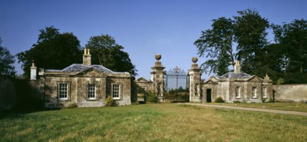
What in the C19 was the principal formal approach across the park from the south departs from the A40 1.2km south-west of the house, from Cheltenham Lodges, a pair of widely set, single-storey ashlar lodges of 1840 by Charles Bailey of Cheltenham. Between them are wrought-iron gates with armorial overthrows supported on stone piers (whole lodge complex listed grade II*). Gates and piers represent the 'New Gate' (date unknown) marked on Taylor's map of 1777, then on the southern extremity of the South Park, 300m to the north of their modern location, to which they were moved in 1840. From here the drive runs 300m north to the east/west estate road across the park, where it stops. In the C19 the drive continued on a slightly sinuous course across the park to the west side of the house.
The east/west estate road runs along the outside (south) of the wall which marks the southern boundary of the later C18 park. At its west end is West Lodges, a fairly substantial two-storey, stone, Arts and Crafts-influenced lodge of 1909, and at its east end, on the east edge of the park, is Home Farm (outside the registered area).
PRINCIPAL BUILDING
Sherborne Park (listed grade II*) was probably executed by Valentine Strong of Taynton (d 1662) for John Dutton in 1651-3, building around a mid C16 structure. The main ranges were arranged in a U-plan around a forecourt open to the west. This structure was rebuilt by Lewis Wyatt (d 1853), who reproduced the style of the C17 house, in 1829-34. Wyatt's house is a three-storey, square ashlar building set around a central courtyard. The house was converted into flats in 1981.
Standing against the north-east corner of the house is the church of St Mary Magdalene (listed grade II*), a late C13 and early C14 building rebuilt in the 1850s, possibly by Anthony Salvin (d 1881) who in the early 1840s was brought in to remodel the house's interior. Its spire is a striking feature of the landscape.
Some 30m north-east of the house is a quadrangular stable block (listed grade II) of the 1770s and possibly by John Donn, of ashlar with a slate roof and with a round-headed entrance in the centre of the north side. It was converted to residential use in the early 1980s, and a garden laid out in the courtyard. An earlier, rectilinear, stable block (listed grade II), now the estate office, lies c 50m to the east. A late C16 building rebuilt in the C17 and early C18, it is of coursed squared and dressed limestone with a stone slate roof.
Among the service buildings east of the house is a Meat House (listed grade II; now electricity sub-station), a mid C19 ashlar building in the style of the mid C18 stable block which it stands 50m south of.
GARDENS AND PLEASURE GROUNDS
Against the west side of the house is a turning circle and formal garden of c 1971 bounded to the south by c 5m high, older, yew hedges. A low flight of steps (?mid C19) gives access from the centre of the west side of the garden to a lawn which extends for c 120m from the garden. A flight of balustraded steps leads from the south-east corner of the west garden, against the house, to the lawn which runs along the south side of the house and the garden wall to its east. On the lawn are specimen trees and shrubs, including mature examples. Running eastward from the house for c 170m is an early to mid C19 ashlar garden wall, which at its east end returns south for 35m. Midway along the main section of the wall is a mid C19 Orangery (listed with wall grade II), its main, south facade of five bays. In front (south) of the Orangery is a rectangular pool (?later C20) with a balustraded parapet at its west end.
The house stands at the head of a rectangular Pleasure Ground, 450m long from north to south by 200m wide, defined in part by iron railings. The Pleasure Ground runs south, uphill, away from the house. Its southern half is secondary mixed woodland within which there are mature specimen trees. Mown paths lead through the wood and to a circular iron seat, probably early C19, which stands around a yew tree. The northern part of the Pleasure Ground, formerly lawn, was planted up in 1977 as woodland, Jubilee Covert. A 60m wide arm of the Pleasure Ground extends eastwards along the south side of the kitchen gardens as far as the east border of the park, where it is bounded to the south by a ha-ha. This connects to a shelter belt carrying a track to the Home Farm 500m to the south. In the eastern extension of the Pleasure Ground, c 110m south-east of the Orangery, is a mid C19, single-storey, flat-roofed ashlar seat (listed grade II). This looks south across the eastern part of South Park.
The Old Icehouse (listed grade II), a mid to late C18 icehouse with segmental-headed doorway, is situated c 50m south of the south boundary of the Pleasure Ground.
A document of 1622 (see Fretwell 1990) mentions a bowling alley. Kip's view (Atkyns 1712) shows a series of garden and orchard compartments west of the house, extending as far as a public road south from Sherborne village (later closed). His view also hints at informal gardens or grassland south of the house. Rudder, however, writing c 1779, claimed that the gardens and outbuildings shown by Kip never existed. In 1711-12 accounts record the levelling of banks in the old garden around the House. New gardens were laid out in 1723-5 with terraces, stone walls, and clipped yews. In 1821-2 William Sawrey Gilpin (d 1843) was employed for fifty-five days at Sherborne; it is unclear what improvements were carried out, although they may have included planting trees both in the Sherborne parks and at Lodge Park. The Pleasure Ground was present by c 1820. At that date its northern two-thirds were open and encompassed by an oval carriage ride from the house, while the remainder was wooded. In 1840 the ground around the house was levelled. The present garden planting scheme is of c 1971.
PARK
The parkland lies both north and south of Sherborne Lane. The former, Old Park, represents an enlargement of the deer park enclosed in the later C16. South Park was enclosed later and has a more complex history.
Old Park comprises c 60ha of permanent pasture, subdivided into several large fields by hedges and wire fences. To the east, west, and north it is enclosed by a stone wall, c 1.5m high and with triangular stone coping. Running east/west through its southern part is the Sherborne Brook, here held back by weirs to form a 20-30m wide lake. To either side is lush meadowland with some mature parkland trees. At the east end of the lake, adjoining Mareslaid Copse, are a boathouse and turbine house, both of 1898-9. An arched stone causeway crosses the weir 200m north of Sherborne Park, carrying a track to Sheafhouse (listed grade II), a quadrangular group of limestone agricultural buildings of 1831. In the high ground of the north-east of the park are earthworks including hollow-ways and, possibly, vestigial ridge and furrow. Generally, in the northern, upper part of the park there are relatively few mature parkland trees, and there are views south to the house and its kitchen gardens. Close to the south-east corner of the park, 100m east of the walled kitchen garden, is Dairy Farm (listed grade II), a quadrangular range of farm buildings with a stone farmhouse (dated 1907) attached to its north-west corner.
South Park, c 200ha, lies south of the house, and is bounded to the south by the A40. Wide shelter belts run behind the park wall either side of the Cheltenham Lodges, continuing as narrower belts up the east and west boundaries of the park. The northern two-thirds of South Park, running uphill from Sherborne Park and village, is permanent pasture with large numbers of parkland and specimen trees. In the centre-south of this part of the park, south of and adjoining the Pleasure Ground, is Quarry Wood, within which is a disused stone quarry from which stone was got for several Oxford Colleges and St Paul's Cathedral, London. The southern third of South Park is divided into large, straight-edged fields in arable cultivation. Some 200m east of West Lodge are the mid C19 Ewepen farm buildings (listed grade II), including a barn of 1860 and open-fronted shelter sheds, all of stone.
Old Park was laid out as a deer park in the late C16, probably over Sherborne's north field (see Fretwell 1990). Kip's early C18 view (Atkyns 1712) shows a deer park (reckoned at 50ha in 1622) north-east of the house, the position of its west boundary ambiguous but south of Sherborne Brook extending up to Sherborne Lane. At this date the Sherborne Brook was still narrow. The date when it was broadened into a lake is not known; Isaac Taylor's county map of 1777 appears to show the lake. By the early 1820s, and perhaps long before, the deer had been removed, there was a building on the site of Sheafhouse, and the park had been split into fields. The South Park was in existence by 1777 (Taylor), although at that date it extended only 750m south of the house. Taylor's map of 1777 marks 'New Gate' in the centre of the south side, probably at the south-west corner of the modern Quarry Wood. By 1833 the park had been extended south to the A40; then, as now (late C20), this southern third of the park was divided into fields. Collectively the two Sherborne parks were called 'cow park' c 1820, to distinguish then from the 'deer park' (Lodge Park).
KITCHEN GARDEN
The C18 and early C19 walled kitchen gardens (walls listed grade II) lie 200m east of the house. The main compartment is rectangular, 90m east/west by 65m, and the walls, variously of ashlar and brick, stand up to 5m high. It was largely uncultivated in 1999. No internal structures survived. Against the outside of the north wall is The Bothy (listed grade II as The Bungalow), a mid C19 single-storey stone building with slate roof. Against the outside of the north end of the east wall is an open-fronted, seven-bay store (listed grade II) of the late C18 or early C19. Against the outside of the south wall is Rose Cottage, a late C18 or early C19 two-storey gardener's house with a polite, parapetted ashlar facade. Running eastward from Rose Cottage along the outside of the garden's south wall is a 45m long lean-to glasshouse of the mid to late C19 with a central projecting entrance. Some 10m south-west of Rose Cottage is Sherborne Gardens (listed grade II), a long and narrow C17 and later stone house and offices rebuilt in the C19.
Abutting the west side of the main garden is a second compartment c 60m square, parts of which were under cultivation in 1999. Abuting the east side of the main garden is a third walled area, roughly triangular and extending as far as the public road. In 1999 this was an adjunct of a commercial nursery with polytunnels which occupied a fourth garden compartment, south of Sherborne Gardens.
In 1729 (Fretwell 1990) over 80,000 bricks were made for a new kitchen garden wall, and soon after there were other works and the construction of a melon ground. Until 1821 Sherborne Lane ran around the west and south sides of the walled gardens; in that year it was diverted to its modern line, along the north side of the gardens.
REFERENCES
R Atkyns, The Ancient and Present State of Gloucestershire (1712), plate facing p 644
S Rudder, A New History of Gloucestershire (1779)
H Colvin, Biographical Dictionary of British Architects 1600-1840 (1978 edition), p 791
D Verey, The Buildings of England: Gloucestershire The Cotswolds (2nd edition 1979), pp 394-8
Country Life, 179 (20 March 1986), pp 720-3
K A Fretwell, Sherborne and Lodge Parks: Park and Garden Survey, (report for National Trust 1990)
Maps
Isaac Taylor, Map of Gloucestershire, 1777
OS 6" to 1 mile: 1st edition surveyed 1881-3, published 1884-6
Description written: June 1999
Edited: April 2003
- Visitor Access, Directions & Contacts
- History
The following is from the Register of Parks and Gardens of Special Historic Interest. For the most up-to-date Register entry, please visit the The National Heritage List for England (NHLE):
www.historicengland.org.uk/listing/the-list
HISTORIC DEVELOPMENT
Sir Thomas Dutton (died 1581) acquired the manor of Sherborne, before the Dissolution a possession of Winchcombe Abbey, in 1552. Before the end of the century his son William (died 1618) had inclosed a deer park north-east of the House. William's son Sir John Dutton (died 1657), known as 'Crump' Dutton from his hunchback, created a new deer park (Lodge Park - see separate description of this site in the Register) 4 kilometres to the south-west in about 1630. He was succeeded by his nephew, William (died 1675), and he by his son Ralph (died 1721), who dissipated the family fortune by gambling and sporting. In 1709 the estate was transferred to his son, the cultured John Dutton (died 1743), whose two marriages to heiresses allowed improvements to the estate, including the construction of new gardens in the 1720s. His heir was his nephew John Lenox Naper (died 1776), who took the name Dutton. His son and heir, James Dutton (died 1820), was created Lord Sherborne in 1784. Further estate works, including the rebuilding of Sherborne village, took place in the middle of the 19th century. The family stayed at Sherborne until the Second World War. Sherborne Park was sold in 1971 and converted to flats in 1981, and its stables also in the early 1980s. The estate was bequeathed to the National Trust, in whose ownership it remains (1999), by the seventh Lord Sherborne on his death in 1982.
Period
- Post Medieval (1540 to 1901)
- Tudor (1485-1603)
- Associated People
- Features & Designations
Designations
The National Heritage List for England: Register of Parks and Gardens
- Reference: GD1773
- Grade: II
Features
- Mansion House (featured building)
- Description: The house was converted into flats in 1981.
- Earliest Date:
- Latest Date:
- Key Information
Type
Park
Purpose
Ornamental
Principal Building
Domestic / Residential
Period
Post Medieval (1540 to 1901)
Survival
Extant
Hectares
260
Open to the public
Yes
Civil Parish
Sherborne
- References
References
- Atkyns, R and others {The Ancient and Present State of Gloucestershire} (London: W. Bowyer for Robert Gosling, 1712) 644 The Ancient and Present State of Gloucestershire
- Verey, D., {The Buildings of England: Gloucestershire 1, The Cotswolds} (London: Penguin, 2nd edition 1979), pp. 394-8 The Buildings of England: Gloucestershire 1: The Cotswolds
- {English Heritage Register of Parks and Gardens of Special Historic Interest}, (Swindon: English Heritage, 2008) [on CD-ROM] Historic England Register of Parks and Gardens of Special Historic Interest
- Nicholas Pearson Associates {Sherborne House Historic Landscape Survey} (1997) Sherborne House Historic Landscape Survey
- Fretwell, Katie {Sherborne and Lodge Park Survey} (1990) Sherborne and Lodge Park Survey