Introduction
Sale and Brooklands cemetery is a mid-19th-century cemetery that was later extended twice, although only the original cemetery is registered by English Heritage. It has an informal layout of winding intersecting paths and surviving chapels, which are no longer in use. Other features include a Gothic Revival-style lodge and an underpass.
Terrain
Level.
The following is from the Register of Parks and Gardens of Special Historic Interest. For the most up-to-date Register entry, please visit the The National Heritage List for England (NHLE):
www.historicengland.org.uk/listing/the-list
A public cemetery opened in 1862 with designs for buildings and laying out by William Wilson.
DESCRIPTION
LOCATION, AREA, BOUNDARIES, LANDFORM, SETTING
The c 2.7ha cemetery is situated c 200m to the south of Sale town centre. To the south the cemetery adjoins Marsland Road, which rises to the east to cross Marsland Bridge over the adjoining canal and railway line. This boundary is generally marked by a C20 dwarf brick wall topped with late-C20 railings set between low, square brick piers at the head of a steep embankment within the cemetery planted with mature deciduous trees and evergreen shrubs. For c 40m from the south corner of the site the boundary wall tops a stone retaining wall forming part of the structure of Marsland Bridge and for c 30m from the western corner of the cemetery the wall is in stone with stone piers and C19 railings. To the east the site adjoins a footpath on the west bank of the canal and to the north and west adjoins the gardens of early and late-C20 housing respectively. These three boundaries are marked by high brick walls partially lined with trees. There are dramatic views down into the level cemetery ground from the higher levels of Marsden Road and Marsden Bridge.
Immediately to the south of Marsland Road, with an entrance mirroring that to the northern cemetery, is the late-C19 and C20 extension ground (outside the area here registered). The surrounding area is otherwise predominantly residential.
ENTRANCES AND APPROACHES
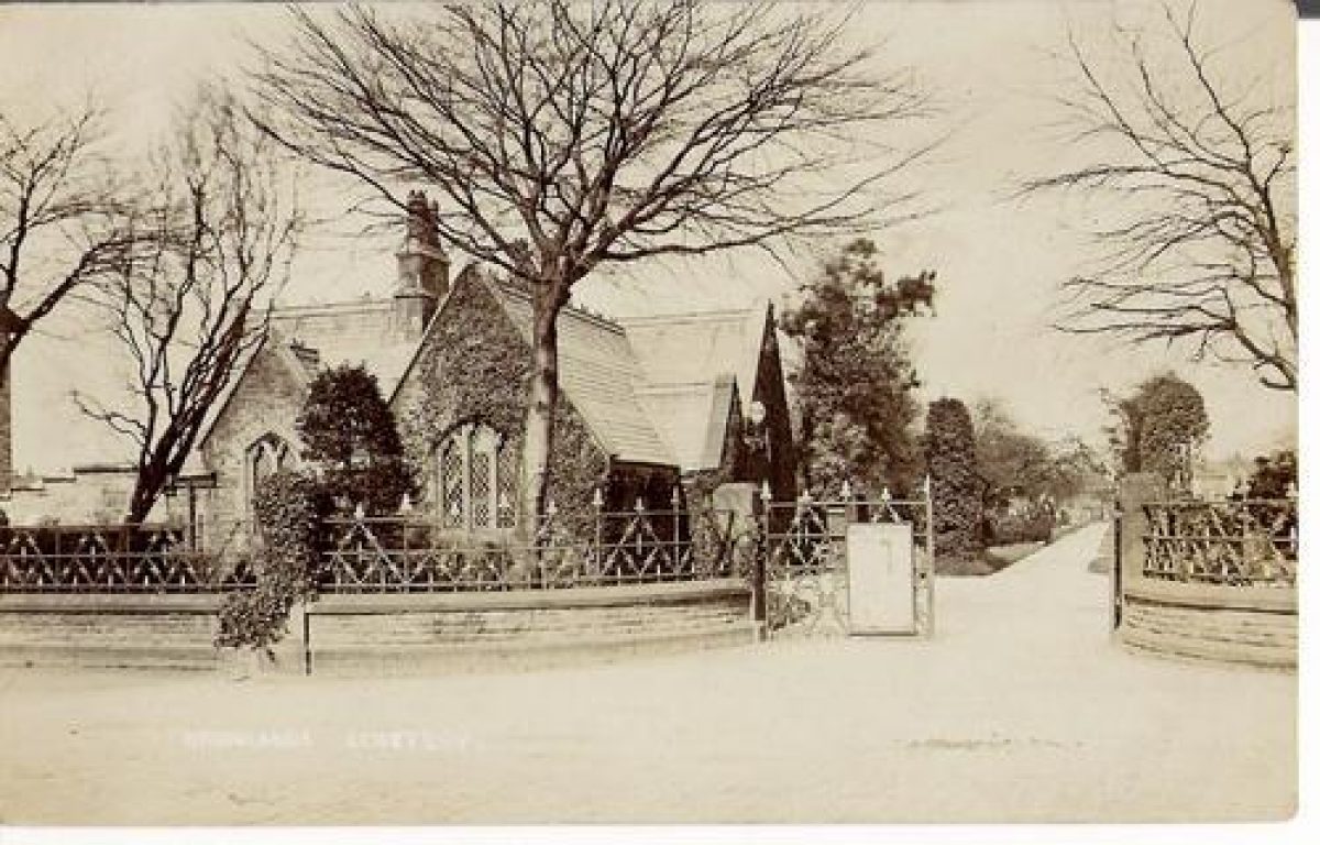
The principal entrance is at the western corner of the site off Marsland Road from which it is slightly set back. It is marked by a carriage entrance with C19 low cast-iron gates with a diagonal motif set between low stone piers. The entrance is flanked by quadrant low stone walls topped with C19 railings, of similar design to the gates. Finials to both gates and railings are C20 replacements. Immediately north of the entrance is a small, single-storey, Gothic Revival-style lodge in pitch-faced sandstone with ashlar dressings below a gabled roof in slate with decorative band courses. The lodge dates from 1861 with the design by William Wilson and is similar in style to the chapels.
In the southern corner of the cemetery an underpass gives access below Marsland Bridge to the extension ground to the south of Marsland Road. The underpass is generally in pitch-faced coursed stone with an ashlar band course on the line of the springing point of the shallow two-centre arched construction and with hood mould detail at the entrances. The underpass is first indicated on the OS map of 1898. Also in the south of the site, a short path from a C20 pedestrian gate gives access from the canal footpath to a small electrical sub-station within the cemetery.
PRINCIPAL BUILDINGS
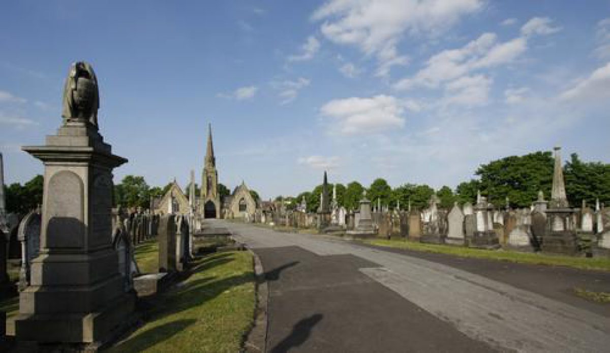
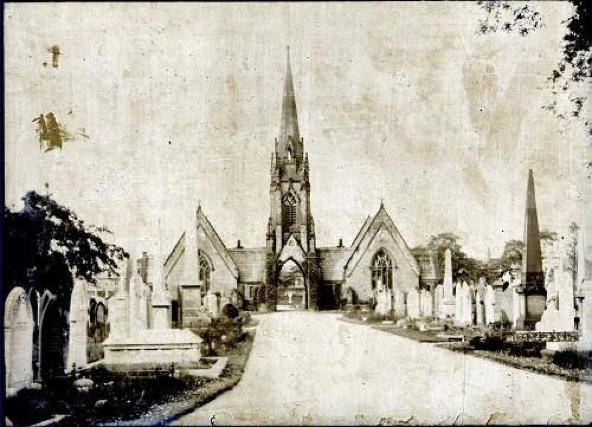
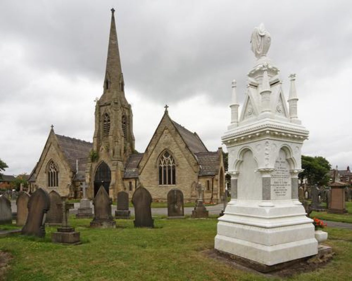
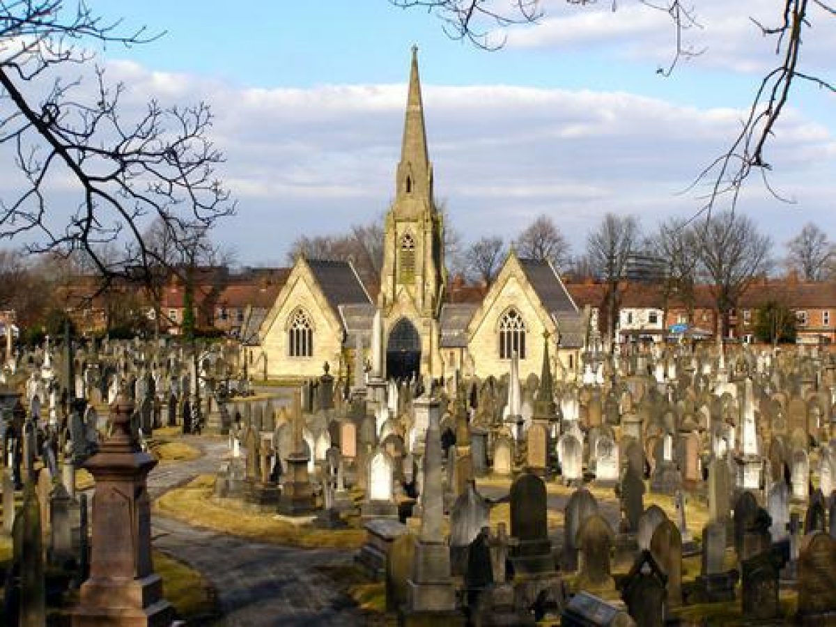
Two linked mortuary chapels (listed grade II) are sited at the head of an axial approach drive c 120m north-east of the principal entrance, with the Nonconformist chapel to the north-west and the Church of England chapel to the south-east. The symmetrical Decorated Gothic Revival-style chapels are in pitch-faced sandstone with ashlar dressings below a slate roof with decorative band courses. They are linked by a porte-cochère, now (2003) blocked, below a two-stage square tower topped by a slender octagonal spire. The chapel design dates from 1861 and is by William Wilson with the spire added in 1902 by Spence, a local stonemason (Brooks 1989).
OTHER LAND
The principal entrance leads into a small forecourt immediately to the south-west of the lodge. From here the main entrance drive curves eastwards for c 50m before straightening to form an axial approach to the chapels, dividing the south-west area of the cemetery. The axial drive divides around the chapels, forming a carriage turn, to continue as an axial path dividing the north-east area of the cemetery; the path terminates at a circular feature adjacent to the north-east boundary.
Some 25m east-south-east of the principal entrance a perimeter path leads off the main drive, curving eastwards before running parallel with the eastern boundary and from the forecourt a second, straight, perimeter path leads off northwards. In the northern part of the cemetery these two perimeter axial paths curve to meet the central axial path, in a symmetrical arrangement, c 40m north of the chapels. The perimeter paths form part of a flowing design of eight ovoid and tear-drop-shaped burial areas laid out in a generally symmetrical pattern around the axial drive and path, with six of these areas radiating outwards from the carriage turn around the chapels. Some 50m to the east and north-west of the chapels two junctions with the perimeter path are marked by small triangular burial areas, forming part of the symmetrical layout. In the south-west area of the site two of the tear-drop-shaped burial areas are divided in part by a large triangular burial area at the south-west end of the axial drive. The whole of this layout is as shown on Wilson's plan of 1861 apart from subdividing curving paths within the two tear-drop-shaped areas to the south-west, which are first indicated on the OS map of 1910. Some 90m east-south-east of the principal entrance a gently winding path leads south off the perimeter path to the underpass below Marsland Bridge. This path is first indicated on the 1898 OS map.
The cemetery contains a great density of notable C19 and early-C20 monuments, in a wide variety of sizes, styles, and materials, and the graves of many notable local people. In the south-west of the cemetery are an elaborate Gothic-style headstone framing a stained glass representation of Christ, a large Classical-style white marble tablet to Max Essayan (d 1923), the base adorned with a seated female figure, and the imposing Gothic-style gabled red marble canopy of the Benton memorial, now (2003) without the portrait bust of George Benton (d 1887). To the south of the Anglican chapel is the c 1889 Lord family monument in white marble with elaborate, eclectic detailing with pinnacles and gablets surmounted by a draped urn. To the north of the chapels is the quite modest monument to the world-famous scientist, James Prescott Joule (d 1889). Other persons of renown buried in the cemetery include John Benjamin Dancer, the founder of microphotography, and Richard Marsden Pankhurst, the husband of Emmeline Pankhurst who founded the Women's Social and Political Union while living in Manchester.
REFERENCES
Brooks C, Mortal Remains (1989), pp 173-4
Maps
Wilson W, General Plan of Sale Cemetery, 1861 (TSAS 614.61cem), (Trafford Local Studies Centre)
OS 6" to 1 mile: 1st edition published 1882; 1938 edition
OS 25" to 1 mile: 1st edition published 1876-80; 2nd edition published 1898; 1910 edition; 1934 edition
Archival items
The following documents are held at Trafford Local Studies Centre:
Sentence of Consecration from the Bishop of Chester, 1862 (TSAS 614.61cem); Contract between the Burial Board for the Township of Sale and Luke Winstanley, 1861 (TSAS 614.61cem, 1309); Contract between Messrs Watson & Dickinson and Mr Luke Winstanley for Masons Work at Sale Burial Ground, 1861 (TSAS 614.61cem, 1308).
Historical photographs and notes (Ashton and Sale History Society)
REASONS FOR DESIGNATION
Sale and Brooklands Cemetery is designated at Grade II for the following principa lreasons:
* Sale and Brooklands Cemetery is a High Victorian cemetery (1862) laid out for a Burial Board.
* The cemetery and its associated structures were designed by the Manchester architect William Wilson.
* The cemetery has a complex 'butterfly' plan comprising curvilinear walks which define the burial areas.
* The layout of the cemetery, including its associated structures, survives intact.
* The cemetery contains a good collection of C19 and C20 funerary monuments, some commemorating persons of national note.
Description written: January 2003
Edited: December 2009
- Visitor Access, Directions & Contacts
Access contact details
The site is open daily from 8am. Closing times vary seasonally.
Owners
Trafford Metropolian Borough Council
Talbot Road, Stretfield, Manchester, M32 0THOther Websites
- https://historicengland.org.uk/listing/the-list/list-entry/1001563
- https://www.trafford.gov.uk/residents/births-deaths-and-marriages/Deaths/burials-and-cremations/cemeteries-and-crematoria-in-Trafford/sale-cemetery.aspx
- https://britishlistedbuildings.co.uk/101389135-sale-and-brooklands-cemetery-chapel-priory-ward
- https://www.findagrave.com/cemetery/2220347/sale-brooklands-cemetery
- History
The following is from the Register of Parks and Gardens of Special Historic Interest. For the most up-to-date Register entry, please visit the The National Heritage List for England (NHLE):
www.historicengland.org.uk/listing/the-list
HISTORIC DEVELOPMENT
The Burial Board for the township of Sale was formed in c 1858 (Sale History Society pers comm, 2003). A plan for the layout of the proposed cemetery, together with designs for a linked pair of chapels and a lodge, were prepared in 1861 by architect William Wilson of Manchester (Plan, 1861). In the same year the Burial Board entered into a contract for work to the chapels and lodge with Luke Winstanley of Sale who subcontracted the masons' work to Messrs Watson and Dickinson (Contracts, 1861). The main contract stated that all work was to be in accordance with the plan and drawings prepared by William Wilson with contract administration by the Board's surveyor. Home Office approval of the cemetery plan was given on 8 August 1862 and the cemetery was formally opened on 29 August 1862.
The site chosen, fronting onto Marsland Road, was adjacent to a section of the Bridgewater Canal which was opened in 1765 and also to the Manchester to Altrincham railway line, opened in 1849. These two run parallel from north to south, immediately to the east of the site. Brooklands railway station (listed grade II), immediately south-east of the cemetery, was opened in 1859 and this may possibly have influenced the choice of site.
In c 1895 the burial area was extended by c 2ha on land to the south of Marsland Road, immediately opposite the 1862 cemetery (outside the area here registered). The two sections were linked by an underpass below Marsland Bridge (OS 1898). Whereas Wilson's cemetery design comprised a series of sinuous intersecting paths, the late-C19 layout is a formal symmetrical design with the central path at a slight angle to the main axial drive in the 1862 cemetery. The southern ground was again extended in the C20 by a further c 2.3ha (outside the area here registered).
The cemetery chapels remain, but are now (2003) no longer in use. The cemetery lodge is now in use as a groundsmen's office. Sale and Brooklands Cemetery remains in use and in the ownership of Trafford Metropolitan Borough Council.
Period
- Post Medieval (1540 to 1901)
- Victorian (1837-1901)
- Features & Designations
Designations
The National Heritage List for England: Register of Parks and Gardens
- Reference: GD4986
- Grade: II
Features
- Boundary Wall
- Description: A 20th-century dwarf brick wall topped with late-C20 railings set between low, square brick piers at the head of a steep embankment.
- Boundary Wall
- Description: Part of the cemetery wall is in stone with stone piers and 19th-century railings.
- Entrance
- Description: The principal entrance is marked by a carriage entrance with 19th-century low cast-iron gates with a diagonal motif set between low stone piers. The entrance is flanked by quadrant low stone walls topped with 19th-century railings, of similar design to the gates.
- Gate Lodge
- Description: Immediately north of the entrance is a small, single-storey, Gothic Revival-style lodge in pitch-faced sandstone with ashlar dressings below a gabled roof in slate with decorative band courses.
- Earliest Date:
- Latest Date:
- Chapel (featured building)
- Description: The symmetrical Decorated Gothic Revival-style chapels are in pitch-faced sandstone with ashlar dressings below a slate roof with decorative band courses. They are linked by a porte-cochere, now (2003) blocked, below a two-stage square tower topped by a slender octagonal spire.
- Earliest Date:
- Latest Date:
- Tunnel
- Description: The underpass is generally in pitch-faced coursed stone with an ashlar band course on the line of the springing point of the shallow two-centre arched construction and with hood mould detail at the entrances.
- Latest Date:
- Drive
- Description: From the principal entrance the main entrance drive curves eastwards for 50m before straightening to form an axial approach to the chapels.
- Path
- Description: The perimeter paths form part of a flowing design of eight ovoid and tear-drop-shaped burial areas laid out in a generally symmetrical pattern.
- Key Information
Type
Funerary Site
Purpose
Sacred / Ritual / Funerary
Principal Building
Religious Ritual And Funerary
Period
Post Medieval (1540 to 1901)
Survival
Extant
Hectares
2.7
Open to the public
Yes
Electoral Ward
Brooklands
- References
References
- {English Heritage Register of Parks and Gardens of Special Historic Interest}, (Swindon: English Heritage, 2008) [on CD-ROM] Historic England Register of Parks and Gardens of Special Historic Interest
- Brooks, C. {Mortal Remains} (Exeter: Wheaton, 1989), pp. 173-4 Mortal Remains: the history and present state of the Victorian and Edwardian cemetery