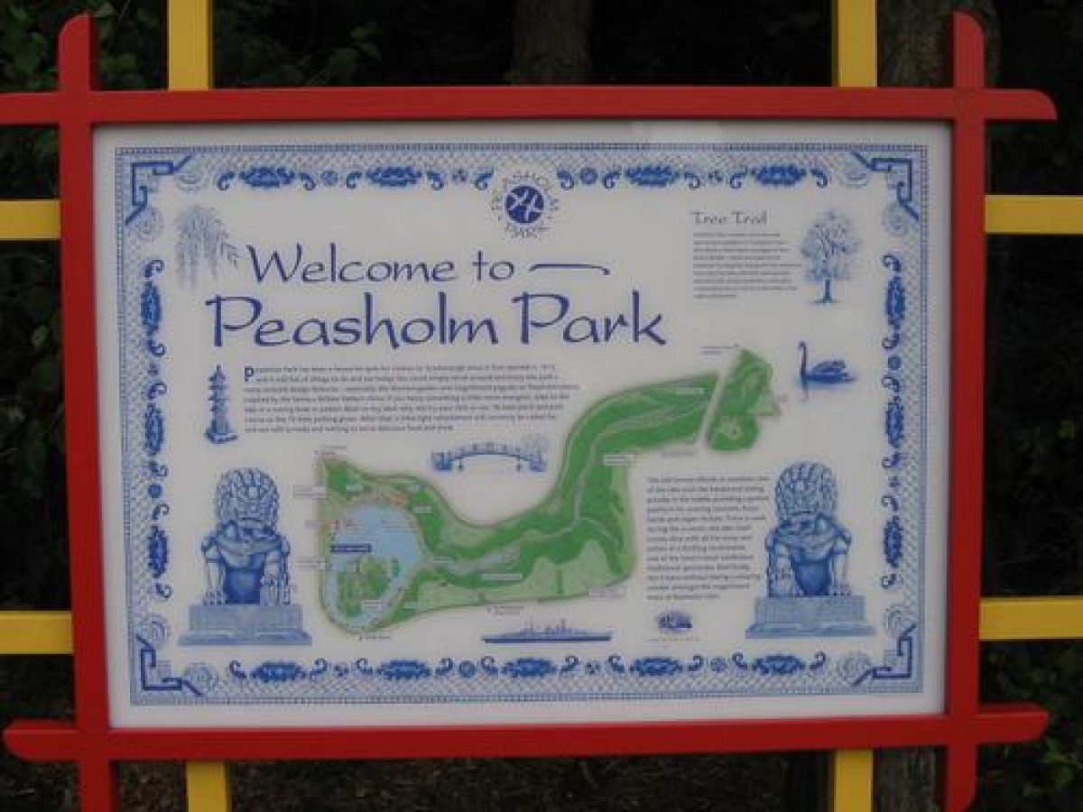
Introduction
A public park laid out in 1912 with a Japanese theme. The park was extended to include Peasholm Glen, a natural ravine, in 1924. This is a public park designed in Japanese style. There is a boating lake, with a bandstand in the middle. An island in the lake has several paths and is surmounted by a Japanese-style pagoda, with an ornamental cascade running down from the pagoda into the lake. There is also a refreshment pavilion. To the south-west of the lake is Peasholm Glen, a landscaped valley with ornamental pools and cascades and a number of specimen trees.
Terrain
The site encompasses a narrow steep-sided valley.The following is from the Register of Parks and Gardens of Special Historic Interest. For the most up-to-date Register entry, please visit The National Heritage List for England (NHLE):
Location, Area, Boundaries, Landform and Setting
Peasholm Park lies on the north side of Scarborough in a largely residential area. The c 14 ha site encompasses a narrow steep-sided valley running north-east towards North Bay. The valley gradually widens until it opens on to low-lying ground as the sea is approached. The south-west tip of the site adjoins a cemetery established in the late C19, and the north-east end of the site is separated from Alexandra Gardens and Northstead Gardens on the seafront by the A165, Columbus Ravine, which forms the boundary on this side. The boundary on the south and south-east side is Peasholm Drive and the walls of the cemetery. On the north side the boundary is Northstead Manor Drive, while the west boundary is formed by residential roads called Ryndleside and Glenside. There is iron fencing in some places but most of the park perimeter is defined simply by pavements or verges alongside the roads.
Entrances and Approaches
The principal entrances are from Columbus Ravine. An entrance at the junction of Columbus Ravine and Peasholm Drive on the east side of the site has two Japanese-style booths probably of mid to late C20 date and a Japanese-style arch of late C20 date. An entrance near the junction of Northstead Manor Drive and Columbus Ravine on the north side of the park has a set of simple Japanese-style arches all of late C20 date. The park can be entered informally from most points around its perimeter, and an entrance from the cemetery is via a set of simple iron gates.
Gardens and Pleasure Grounds
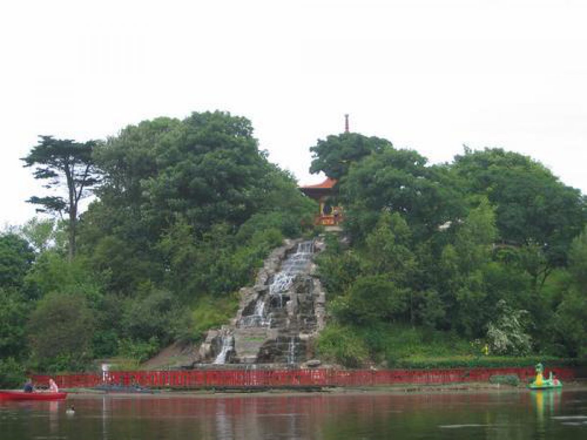
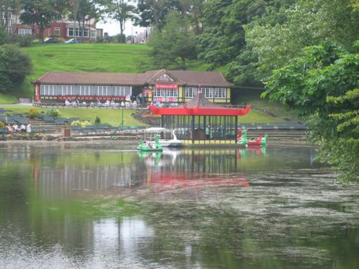
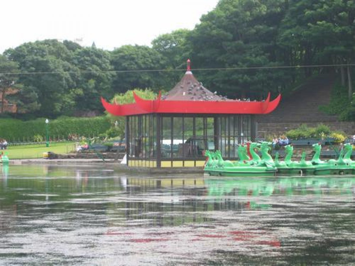
The focus of the north side of the site is a large lake with a central island created in 1912 by damming the Peasholm Beck and excavating a moat-like lake around a natural prominence. Land on the south side of the lake slopes down to the waterside, and most of the amenities are concentrated on this side which offers the best views across the water to the island. A Japanese-style café (restored late C20) lies on a platform cut into the slope, and c 20 m to the south, further up the slope, there is a Japanese-style pavilion of c 1912. Beneath the café stone terraces with seating were laid out by Parks Superintendent John Clark in 1923 to accommodate ever-increasing crowds attracted by the band and other entertainments. Some 80m east of the café a flight of stone steps, probably added at the same time as the terracing, runs down a steep slope and provides additional seating. A bandstand stands c 60m north of the café, on a platform within the lake such that it appears to float on the water. It is in the position of a bandstand shown on the 1930 OS map but the structure was replaced and a new Japanese-style canopy introduced in the late C20. A boathouse, also in Japanese style (c 1912, restored late C20) sits on a platform in the lake c 100m north-east of the café.
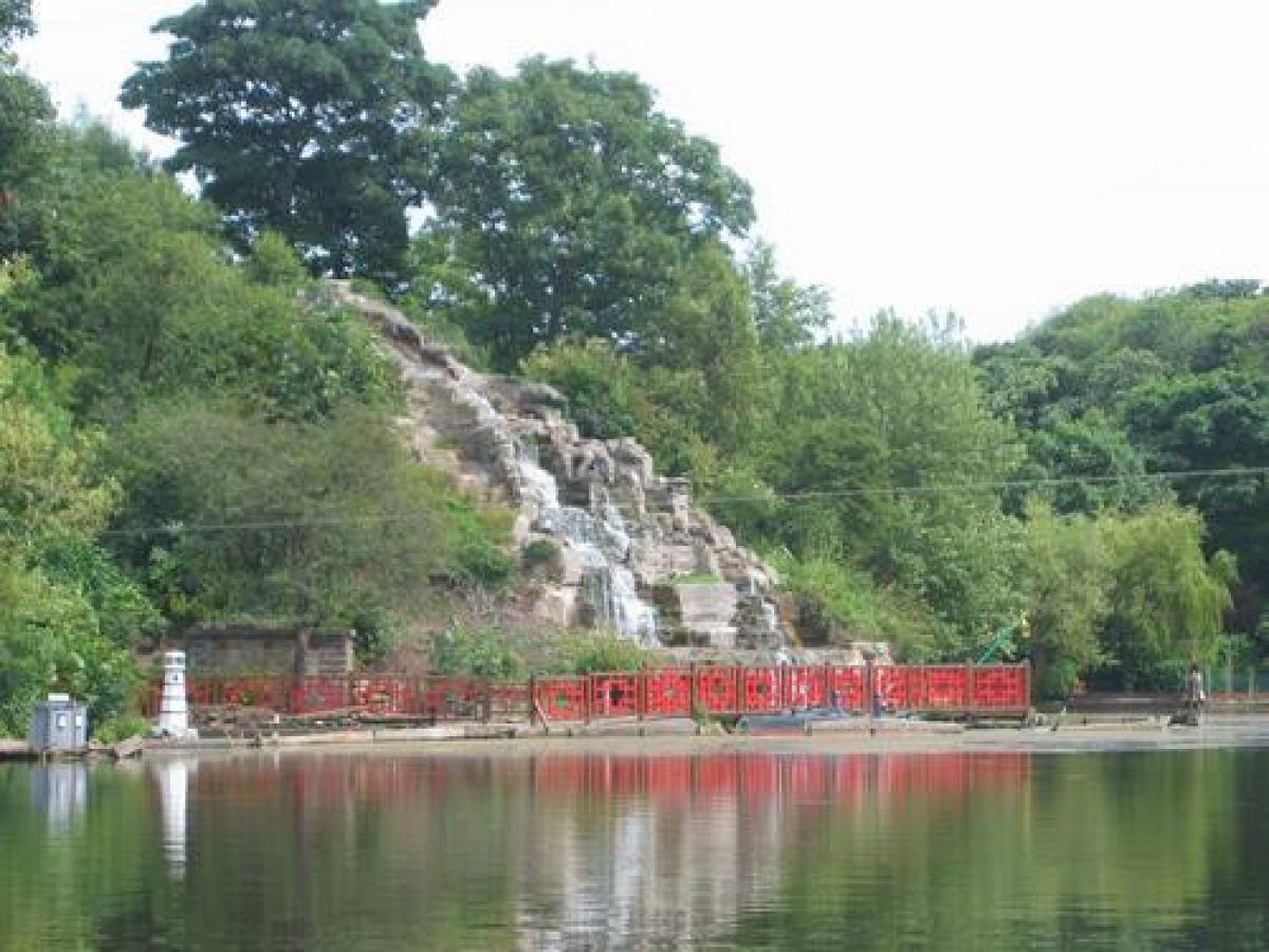
Prominent in views from the south side of the lake is a large rocky cascade (dry and under repair, 2000) which runs down the steep south side of the island. A Japanese-style pagoda stood at the top of the cascade until it was burnt down during the 1990s. Pagoda and cascade were designed by G W Alderson and erected in 1929. Angled cast-iron posts carrying Japanese-style lamps are ranged around the lake margin and linked by ropes of fairy lights. These are shown, with the fairy lights, in a postcard of mid C20 date (reproduced in Lord 1984, pl 62).
The island is reached by a bridge (c 1912, restored late C20) on its east side executed in Japanese 'willow pattern' style and guarded by a pair of stone lions given by Alderman J R Twentyman in 1928. Paths lead around the island perimeter and up to the top where there is a Japanese-style garden (under construction 2000). A Japanese-style pavilion (c 1912, restored late C20) stands beside the water on the south-west side of the island.
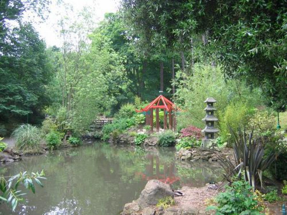
Paths lead around the lake giving changing views of the island. On the west side of the lake the valley begins to narrow and there is a set of linked shallow pools with rockwork margins which were constructed as model yacht ponds in the late 1920s after this part of the park, and Peasholm Glen to the south-west, was acquired in 1924. Stone Japanese lanterns around the lake are the survivors of a number of Oriental statues and ornaments which were bought by the Corporation from the collection of Alderman Twentyman in 1931 and placed in the Glen. There are views northwards to the lake and south-westwards to the wooded valley.
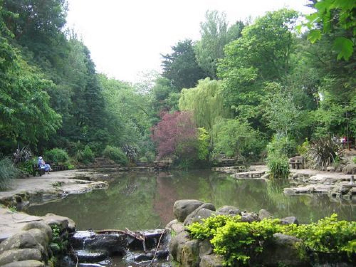
Paths lead south-west alongside the stream, and the Glen becomes narrower and steeper as the route progresses. The stream is lined with stonework and falls as a series of small artificial cascades. It is crossed and re-crossed at various points by simple rustic bridges. The valley sides are clothed with a mixture of native and exotic trees, including varieties of weeping trees and pines which were planted during the late 1920s. Clumps of bamboo and exotic shrubs alongside the stream may also originate from the planting undertaken at this time.
Two paths join the main valley-bottom route at a point c 300 m south-west of the café, close to the point where a bridge crosses the stream. On the north side a smaller stream flows down over rockwork pools and cascades, and a path alongside it continues up the slope to the grassy edges of the valley and Northstead Manor Drive. On the south side a set of stone steps ascends the steep slope and a path from the top of the flight leads out to a grassy area with a small mid to late C20 pavilion (shown on the 1950 OS map) beside Peasholm Drive. The valley-bottom path continues to a point c 500m south-west of the café where the stream emerges from a tunnel. Just to the south the valley is crossed by Peasholm Glen Bridge, a road bridge which was constructed in 1932 (Mouchel and Partners, cladding by G W Alderson; A J Wilson, Scarborough Borough Council pers comm, April 2000). The bridge is balustraded and has refuges to allow pedestrians to look into the Glen. The path continues beneath the bridge and is joined by a path from an entrance on Glenside, then it reaches a sunken garden with an apsidal lily pond with a central plinth supporting a painted statue of Hermes. This feature is shown on the 1950 OS map but not that of 1930. A path leads into the cemetery to the west and another runs south up the valley side to an entrance beside the bridge.
Peasholm Park is an example of an early C20 themed public park in the then popular Japanese style. The extension of the core area to include Peasholm Glen in the 1920s produced a layout allowing visitors to retreat from the bustle of the lake area to a quieter, more enclosed and darker part with naturalistic planting. For those coming from the other direction the approach through Manor Road Cemetery (outside the registered area), part of which is within the Glen, creates the opposite effect, with the enclosed more naturalistic area gradually opening out until the lake is reached.
Maps
- OS 6" to 1 mile: 2nd edition surveyed 1890-1, published 1894; 3rd edition published 1914; 1930 edition; 1950 edition
- OS 25" to 1 mile: 1928 edition
Description written: March 2000
Amended: April 2000; May 2000
Edited: July 2000
- Visitor Access, Directions & Contacts
Website
https://peasholmpark.com/Access contact details
The site is open daily throughout the year.
Owners
Scarborough Borough Council
Town Hall, St Nicholas Street, Scarborough, North Yorkshire, YO11 2HG
- History
The following is from the Register of Parks and Gardens of Special Historic Interest. For the most up-to-date Register entry, please visit The National Heritage List for England (NHLE):
The park is on the site of the medieval manor house of Northstead.
14th Century
The manor had been part of the Crown Estate from the 14th century.
20th - 21st Century
By the beginning of the 20th century the area was open land used for farming and as allotments.
In 1911, Scarborough Corporation bought the land from the Duchy of Lancaster in order to create a public park. In 1924 the park was extended south-westwards along Peasholm Glen following the purchase of land from the Duchy of Lancaster and the Burial Board in 1921. Parts of the east side of the Glen were in private ownership and these were given to the Corporation. The park was used for aquatic displays, musical performances and evening firework and light displays, becoming immensely popular in the immediate pre- and post-Second World War period.
After a period of decay a programme of restoration was initiated and is currently underway (2000). The park remains open and in public ownership.
Period
- 20th Century (1901 to 2000)
- Early 20th Century (1901 to 1932)
- Features & Designations
Designations
The National Heritage List for England: Register of Parks and Gardens
- Reference: GD4312
- Grade: II
Style
Japanese-Style Garden
Features
- Pagoda
- Description: Japanese-style Pagoda at the summit of the island. Burnt down 1999, rebuilt 2007.
- Earliest Date:
- Latest Date:
- Cascade
- Description: Ornamental pools and cascades in Peasholm Glen.
- Earliest Date:
- Latest Date:
- Waterfall
- Description: Ornamental cascade falling from the Pagoda on top of the island into the lake.
- Earliest Date:
- Latest Date:
- Ornamental Bridge
- Description: A willow pattern bridge leading to the island.
- Bandstand
- Description: A bandstand in the middle of the lake, only accessible by boat.
- Lake
- Description: Boating lake
- Statue
- Description: Several oriental statues are placed around the park.
- Key Information
Type
Park
Purpose
Ornamental
Principal Building
Parks, Gardens And Urban Spaces
Period
20th Century (1901 to 2000)
Survival
Extant
Hectares
14
Open to the public
Yes
Electoral Ward
North Bay
- References
References
- {English Heritage Register of Parks and Gardens of Special Historic Interest}, (Swindon: English Heritage, 2008) [on CD-ROM] Historic England Register of Parks and Gardens of Special Historic Interest
- {Peasholm Park Historic Landscape Survey} (2000) Peasholm Park Historic Landscape Survey
- The Gardeners'' Chronicle, Vol. 16: A Weekly Illustrated Journal of Horticulture and Allied Subjects; July to December, 1894 Gardener's Chronicle, no 16
- Pamphlet style book: plates 59-68 Scarborough's Floral Heritage
- Naumachia: "naval Warfare", in Peasholm Park, Scarborough ; Flourishing Survivor of the British Parkland Tradition of Naumachia, Or Mock Naval Battle 'Naumachia', New Arcadian Journal 39/40