Introduction
The grounds comprise the remains of a 16th-century deer park with 18th-century landscaping. The park surrounds a house mainly dating from the 16th century.
Terrain
Elevated position, on the brink of the Cotswold escarpment.www.historicengland.org.uk/listing/the-list
Remains of C16 deer park, with landscaping of 1790s, around a small country house begun c 1550 as a hunting lodge.
DESCRIPTION
LOCATION, AREA, BOUNDARIES, LANDFORM, SETTING
Newark Park stands on the brink of the Cotswold escarpment, with extensive views to the south-east over the Ozleworth Bottom valley which runs from south-west to north-east below the house. To the north the crescent-shaped registered area (c 50ha) abuts Park Lane, an unclassified road leading to Wotton-under-Edge, 2.5km to the west. To the south the registered area extends to Hillmill Lane, the minor road which runs along Ozleworth Bottom. Combe-like side valleys (including Muscovy Bottom) cut north-west up the main valley side.
ENTRANCES AND APPROACHES
Lion Lodge, at the main entrance, stands 500m north-east of the house. There was already a lodge here in 1798 (Estate map). It is approached from the north-east along the 600m long drive through the hillside Fernley Plantation, midway along the north side of which is Fernley Lodge on whose site there was already a building in 1798. The present Lion Lodge, a rendered one-and-a-half-storey structure with decorative details including fretted bargeboards, is perhaps (at least externally) of the 1830s. From its gates, whose piers are surmounted with statues of lions, perhaps added in the 1830s, a gently curving drive runs across the level parkland to the north side of the house which is first seen about halfway along its length. A back drive runs parallel to this, 100m south-east and downslope of it, to the stables courtyard east of the house.
Reform Lodge, a gothick building of 1798 (but perhaps renamed c 1832) with ogee windows, battlemented parapet, and segmental pediments, stands 350m north-north-west of the house at the corner of the park. A path with C20 beech, sycamore, and horse chestnut leads between them.
A spectacular approach, part - like, presumably, the Fernley approach - of the landscaping of the 1790s, is along the drive which climbs through woodland, via a series of turns, from Lower Lodge, 1km south of the house. In the late C20 this is an unmetalled track, which provides occasional glimpses of the scarp-edge house through the undergrowth and woodland. Lower Lodge (listed grade II), probably also of the 1830s, is a small, square, two-storey building with gothick detailing with contemporary gates.
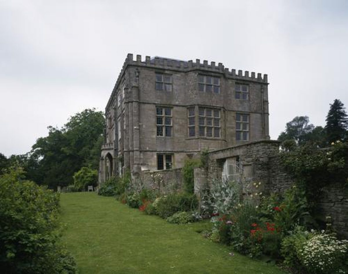
PRINCIPAL BUILDING
Newark Park (listed grade I), the earliest and main phase of which is of 1544-56, is an ashlar building with a main, east facade of three storeys above a basement and three bays, that to the centre projecting as an oriel with a pedimented door to the ground floor. The materials came from Kingswood Abbey. The battlements which surmount the facade were added by James Wyatt as part of the alterations which he made to the house in the 1790s. As constructed, the building was not intended for permanent occupation. It had a basement kitchen, two ground-floor rooms, and above that two floors each with a single large chamber to be used for banquets or for viewing the hunt. Access between floors was via a staircase turret. The architect is not known, although it is suspected that Poyntz, a personal friend of Henry VIII, may have received assistance from the Royal Works. In the early or mid C17 the lodge was turned into a permanent residence by the addition of a parallel block, linked to the old house by the staircase turret. Wyatt turned this H-plan house into what is essentially the present structure by filling in the area between the wings and by providing the south front which has spectacular prospects over Ozleworth Bottom. The only significant later alteration was the addition of a servants' wing on the north side in 1897. The house has been sensitively repaired since the 1970s.
Some 100m east of the house, below and largely hidden from it, is a late C19 stables and coach-house block with attached agricultural buildings of the late C18 or early C19 (all listed grade II). These are part of the Home Farm complex.
GARDENS AND PLEASURE GROUNDS
Against the east side of the house is a forecourt bounded by 2.5m high rubble-stone walls. This was built in the 1970s by Robert Parsons, the house's tenant. The walls are pierced by gates to north and south and by an axial gateway with tall, wrought-iron gates in the east wall. This gateway is purely decorative, as beyond is a mature shrubbery. The interior of the court is a lawn with box-hedged formal gardens, again 1970s. Other gardens of this date lie north-east of the house. These are bounded by a ha-ha, presumably of the 1790s. This extends to the angular junction between the north and south sections of the park. West of the house there is a large area of lawn, with mature ornamental woodland, the Glade, beyond. The south-east corner of the lawn leads to a 10m wide grass terrace (?1790s) along the south front of the house, at the east end of which is the Peacock House, a pergola alcove flanked with columnar yew, part of the 1970s work. The south edge of the terrace, from which there are expansive views over the pleasure ground below, the park, and across the Ozleworth Valley, is bounded by a low iron fence (?1830s), below which the ground falls 10m down a cliff face.
Steps off the west end of the terrace down a gothick bastion turret (c 1975), and a path from the stables court, give access to a winding network of paths through rockeries (decayed, late C20) which occupy the sloping wooded ground below the cliff face. The cliff face itself is partly revetted and supported by stone walling in which, east of the house, there is a cave or alcove. The paths and rockeries, and a pool or dripping well, represent part of the wilderness garden planted in the earlier C20 by Miss King but little tended after c 1940. From this area there is access to the lakeside pleasure grounds c 100m to the south-west. The main route from the house down to the pleasure ground is via a sloping terraced path, through the Glade south-west of the house. This path leads via a small, stone, gothick folly in the form of a ruined castle, perhaps of the 1830s (restored 1984) on the site of an earlier privvy. From the folly's roof there are extensive views over the park and Muscovy Bottom. The woodland includes C19 horse chestnut and beech and has an understorey with holly and box, some of the latter, along the path edge, clipped.
The pleasure ground lies along a 150m long lake, slightly serpentine, and aligned east/west along a slight terrace. Towards the east end of the lake's north shore is the Monkey House, a small orangery or summerhouse (listed grade II) of the 1790s, of brick with stone detailing, and with three ogee arches to the west front and one to either side. The building is abutted by a 2m high brick wall (listed grade II), the earliest sections of which are probably of the 1790s but with alterations as recently as the 1970s, which runs west from it c 50m north of the north side of the lake. The wall curves irregularly, with sections, especially near the Monkey House, being crinkle-crankle (part of the 1970s reworking). The sloping ground between the wall and the lake, presumably once laid out as a decorative pleasure ground, is lush grassland. Lake, summerhouse, and wall are all of the 1790s.
PARK
The park divides into two parts, north and south of the house. Both parts are contained within a stone wall, built or reconstructed in 1792 following exchanges with adjoining landowners to rationalize the boundary. To the north, crossed by the main drive from the Lion Lodge, is level grassland with occasional parkland trees including cedars. Along the north edge of the park is a thin shelter belt; deer sheds which formerly stood against the park wall have been demolished. The park has not had deer since the 1930s.
South of the house the park embraces the wooded western side of the Muscovy Bottom valley, through which passes the drive from Lower Lodge.
KITCHEN GARDEN
Before the late C19 there was a kitchen garden with melon ground at the Home Farm. In 1897 the pleasure ground along the north side of the lake was converted to a kitchen garden and a section of the curving wall along the north side of the pleasure ground raised as the back wall for two glasshouses. The raised wall is all that remains of this kitchen garden.
REFERENCES
D Verey, The Buildings of England: Gloucestershire The Cotswolds (2nd edn 1979), p 356
Country Life, 178 (3 October 1985), pp 943-7
N Kingsley, The Country Houses of Gloucestershire, Volume One, 1500-1660 (1989), pp 138-40
N Kingsley, The Country Houses of Gloucestershire, Volume Two, 1660-1830 (1992), pp 183-4
Maps
Estate map, 1798 (copy at Newark Park)
OS 6" to 1 mile: 1st edition surveyed 1881, published 1886
Description written: March 1999
Amended: May 2001
Register Inspector: PAS
Edited: April 2003
- Visitor Access, Directions & Contacts
Telephone
441453842644Access contact details
The house and gardens are open on Wednesdays and Thursdays from April to October. Also open at the weekends from June to October. Please see: http://www.nationaltrust.org.uk/place-pages/239/pages/opening-times-calendar
Directions
The house is sign-posted from the main road 1.5 miles east of Wotton-under-Edge.
Owners
The National Trust
Heelis, Kemble Drive, Swindon, SN2 2NA
- History
The following is from the Register of Parks and Gardens of Special Historic Interest. For the most up-to-date Register entry, please visit the The National Heritage List for England (NHLE):
www.historicengland.org.uk/listing/the-list
HISTORIC DEVELOPMENT
The manor of Ozleworth, a possession of Kingswood Abbey, was granted at the Dissolution to its tenant, Sir Nicholas Poyntz, whose main seat was Acton Court (Gloucestershire). Between 1544 and 1556 he constructed a hunting lodge in Ozleworth, marked on C17 county maps as the 'new work', today Newark Park. During the late C16 Newark passed to the descendants of Sir Gabriel Low, a London merchant, who enlarged the lodge and turned it into a permanent house. The house was sold to the Harding family in 1722, they in turn selling it to James Clutterbuck in 1769. He passed it to his cousin, the Rev Lewis Clutterbuck, who became rector of Ozleworth. The Clutterbucks retained Newark until 1949, although from 1897 the estate was let to a Mrs King whose daughter, Miss King, a keen plantswoman and a friend of Gertrude Jekyll, remained here until the Second World War. In 1949 the Clutterbucks gave the 325ha park to the National Trust, in whose ownership it remains (1999).
Period
- Post Medieval (1540 to 1901)
- Tudor (1485-1603)
- Associated People
- Features & Designations
Designations
The National Heritage List for England: Register of Parks and Gardens
- Reference: GD1767
- Grade: II
Features
- House (featured building)
- Description: The house was built as a hunting lodge from 1544-56. It was enlarged in the late-16th century.
- Earliest Date:
- Latest Date:
- Key Information
Type
Park
Purpose
Ornamental
Principal Building
Domestic / Residential
Period
Post Medieval (1540 to 1901)
Survival
Extant
Hectares
50
Open to the public
Yes
Civil Parish
Ozleworth
- References
References
- Kingsley. N., {The Country Houses of Gloucestershire, Volume 1, 1500-1660} (Cheltenham: Phillimore, 1989), pp. 138-40 The Country Houses of Gloucestershire, Vol. I 1500-1660
- Kingsley. N., {The Country Houses of Gloucestershire, Volume 2, 1660-1830} (Cirencester: Phillimore, 1992), pp. 183-4 The Country Houses of Gloucestershire, Vol. II 1660-1830
- Verey, D., {The Buildings of England: Gloucestershire 1, The Cotswolds} (London: Penguin, 2nd edition 1979), p. 356 The Buildings of England: Gloucestershire 1: The Cotswolds
- {English Heritage Register of Parks and Gardens of Special Historic Interest}, (Swindon: English Heritage, 2008) [on CD-ROM] Historic England Register of Parks and Gardens of Special Historic Interest
- Teasdale Environmental Design {Newark Park, Gloucestershire. Conservation Management Plan for the Historic Landscape and Estate Buildings} (2012) Newark Park, Gloucestershire. Conservation Management Plan for the Historic Landscape and Estate Buildings
- Related Documents
-
CLS 1/226/2
1990
-
CLS 1/226/2