Introduction
Moor Park has the remains of an 18th-century landscape park which at its most extensive covered about 240 hectares. It now includes two golf courses, with the remains of 19th/early-20th century formal gardens of 3 hectares. There has also been building development along the boundaries and in the south-east quarter of the estate.
Terrain
The house is built on high ground which rises further to the south and west, falling away to the park boundaries.www.historicengland.org.uk/listing/the-list
An C18 country house with formal gardens of c 1830, surrounded by an C18 landscape park and pleasure grounds laid out by Lancelot Brown c 1753. Charles Bridgeman produced a plan for the pleasure grounds (c 1720s); it is not known how much of this was executed.
DESCRIPTION
LOCATION, AREA, BOUNDARIES, LANDFORM, SETTING
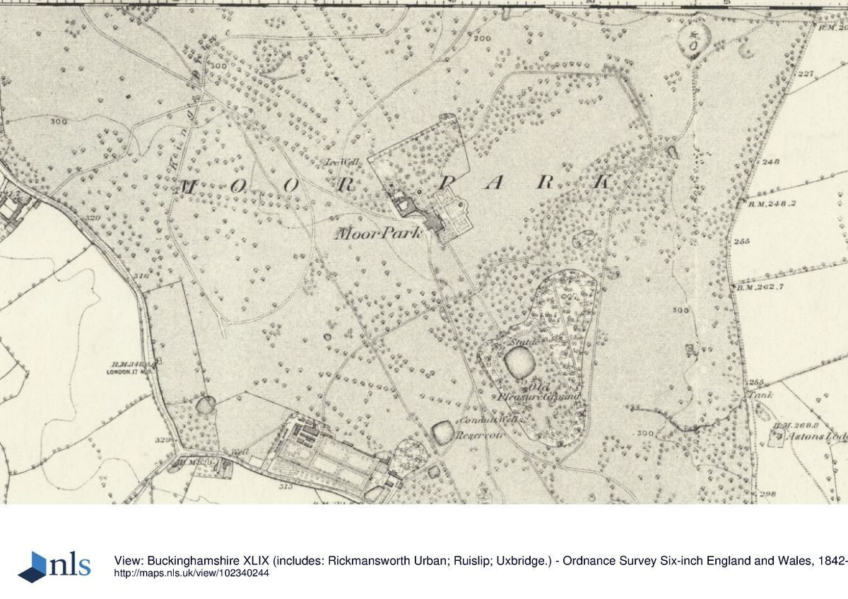
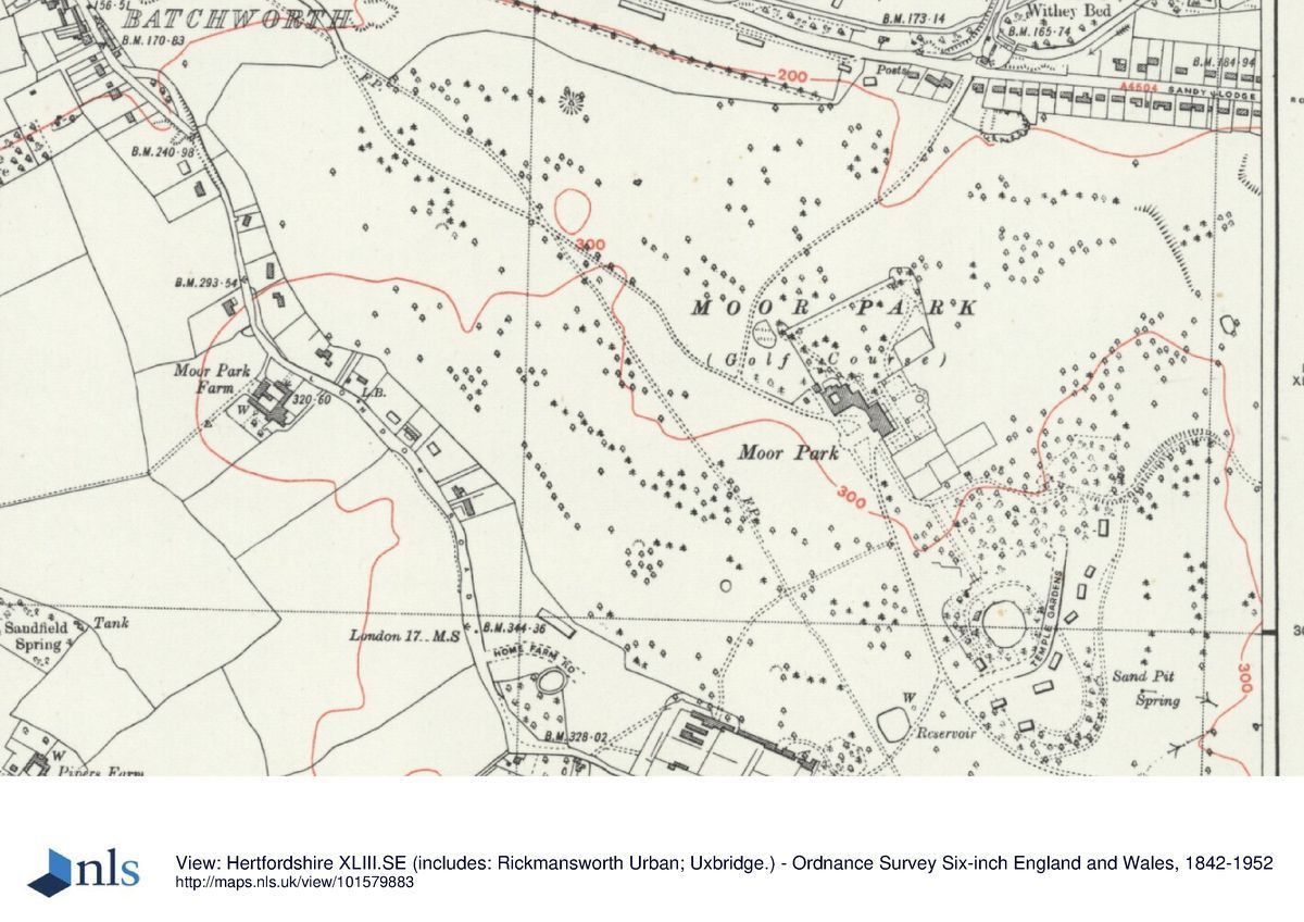
Moor Park lies between Rickmansworth to the north-west, from which it is separated by the River Colne and the Grand Union Canal, and to the south-east the London suburb of Northwood. The centre of Watford lies c 4km north-east of the estate. The roughly triangular, c 115ha estate is bounded largely by a belt of early C20 houses, built along the C19 park boundary which was marked by Moor Lane to the north, Batchworth Heath Hill to the south-west and Pembroke and Astons Roads to the east. The house is built on high ground which rises further to the south and west, falling away to the park boundaries. The setting is rural to the south-west and immediately to the north, and suburban beyond the river to the north and north-west, and to the south-east and east. Long views extend north towards Cassiobury Park (qv) and north-east towards Watford from the high ground running from the north-west to the south-east corners of the park.
ENTRANCES AND APPROACHES
The main approach from London enters the park off Batchworth Heath, 850m south-east of the house, via a stone and rendered entrance arch and flanking pedestrian doorways attached to flanking lodges (c 1763-5, probably R Adam, listed grade II). The drive curves around and up a hill on which stands the circular earthwork Bathend Clump, with views north-east towards Bushey and Watford. It continues north-westwards across undulating ground before descending a hillside overlooking the house, stables and orangery, with long views extending to the countryside beyond. The drive approaches the south-west front via an adjacent open gravel forecourt, now (1999) used as a car park. Stone steps give access to the front door set within a portico the full height of the house. On the north-west side of the forecourt stands the stable block, its south-east range an orangery, now (1999) used as a golf shop, connected to the house by a quadrant link. From here the drive continues north-west through the park, along a ridge, with long views north and east, leaving the park 1.2km north-west of the house and emerging onto Moor Lane, giving access to Rickmansworth and Watford. Opposite this entrance on the north side of Moor Lane, outside the area here registered, stands a former lodge/tea pavilion (R Adam 1763-5, listed grade II), built as a thatched octagonal block with a link to a square block. North-east of this lies an area of brick-walled gardens, adjacent to the canal. In the early C20 the garden adjacent to the tea pavilion was described as 'a charming garden of an informal type with a thatched cottage and summerhouse said to be the work of the Adam brothers' (VCH).
Further drives give access from the north off Moor Lane, past the brick Keeper's Lodge standing 550m north of the house; from the south via Home Farm (this entrance now (1999) partly built over) standing 600m south of the house adjacent to the east side of the walled gardens; and from the north-east off Astons Road, 550m east of the house. This latter drive ascends a hillside as it enters the park, then enjoying long views north-east towards Watford, before passing through a cutting reducing the gradient. The drive curves around the north side of the hill on which Brown's pleasure grounds lie, turning north to arrive at the south-west front.
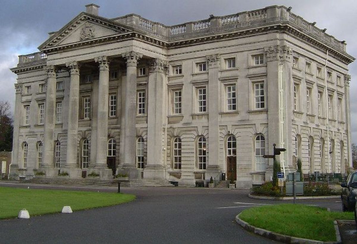
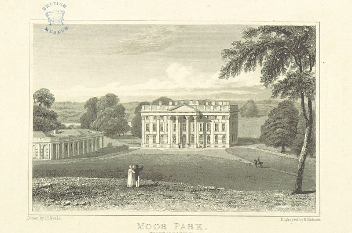
PRINCIPAL BUILDING
Moor Park mansion (C17, rebuilt 1720-8 by Sir J Thornhill, remodelled later C18 including by R Adam, reworked again C19, listed grade I) stands at the centre of the park. The three-storey, rectangular stone building is linked by a stone quadrant link to the enclosed stable yard and orangery (listed grade I with the house) to the north-west. The 1720s rebuilding of the house added two flanking pavilions which were demolished in 1785. The curved quadrant wall may be a remnant of these features, but the stables and orangery seem to be a later rebuilding.
GARDENS AND PLEASURE GROUNDS
The gardens lie to the north, east and south-east of the house, the garden door lying at the centre of the giant order portico on the north-east front. The door leads out onto a flight of broad stone steps flanked by balustrading overlooking the formal Italian Garden, laid out in the 1830s for Robert, second Earl of Grosvenor, cr Marquess of Westminster (d 1845). A sunken basement is surrounded by further balustrading. The steps lead down to the Garden: a terrace laid to lawn crossed by a broad gravel path running parallel to the garden front, bounded to the north-east by a bank overlooking a lower lawn. Four evenly spaced flights of stone steps give access to paths crossing this lawn, leading north-east to the stone garden wall (c 1830, listed grade II) which forms the boundary with the park. A circular stone pool (c 1830, listed grade II) is set on the lawn, aligned with and 50m from the main entrance to the house. At its centre stands a stone dolphin fountain (early C18, listed grade II with the pool). In the early C20 (CL 1912), what is now the lower lawn was laid to gravel, embellished with narrow ribbons of lawn, and set with a formal geometric pattern of beds. Adjacent to the south of the Italian Garden lies a block of tennis courts.
The south end of the terrace walk gives access to a formal area on the south-east front, reached from the house via french windows leading out onto a raised stone balcony with iron railings. At either end of the balcony, steps lead down to a gravel path aligned on the centre of the south-east front, flanked by panels of lawn. A low stone wall (c 1830, listed grade II) bounds the south-west side, in which low stone gate piers flank a path out to the forecourt. The wall extends c 25m from the south corner of the house, turning north-east and continuing on to enclose the rest of the formal garden.
The north end of the terrace walk on the north-east front gives access to an informal pleasure ground lying north of the house. A stone former pond basin lies c 30m north of the house, now (1999) used as a flower bed and shaded by a very large cedar of Lebanon. From here an informal lawn, now (1999) laid out as a golf practice area, extends down a gentle gradient to the north, formerly flanked to west and east by paths (OS 1898) and planted with specimen trees. The lawn, as formerly did the paths, leads north to the north terrace, a broad grass terrace with the remains of a gravel path overlooking the north park and beyond, the views extending north and north-east towards Cassiobury Park (qv) and Watford. The terrace is bounded and retained by a brick wall on which stands a solid stone wall (c 1830-40, listed grade II). The ends of the terrace are marked by two elaborately carved stone seats (in parlous condition, 1999). A flight of stone steps (derelict, 1999) leads south down from the north-east end of the terrace, formerly giving access to the path (its northern end now lost) which leads back to the north front and the Italian Garden.
The Old Pleasure Ground lies 250m south-east of the mansion, formerly (OS C19) reached from the south-east front via an axial path but now (1999) partly lost beneath C20 tennis courts. The path reappears c 120m from the house, continuing through the park up a hillside to the remains of a formal entrance (late C19, listed grade II) to the pleasure grounds, lying 250m from the house. Here a flight of stone steps leads up to a stone retaining wall topped by balustrading which supports a rough grass platform with a further short central flight of steps up to a higher level. To the north-east and south-west two flanking flights of stone steps lie within shrub planting (steps derelict and planting overgrown, 1999). From the higher level a grass ramp leads up to a statue (listed grade II) standing at the edge of an oval pond. The ramp is flanked by woodland with an understorey of rhododendrons and laurels. The south-east bank of the pond is bounded by lawn, beyond which stand a number of early to mid C20 houses, part of the C20 development called Temple Gardens. Formerly (OS C19; CL 1912) the entrance to the Old Pleasure Ground was laid out with clipped lawns and gravel paths giving access to a path through the open woodland which encircled an open lawn dotted with specimen trees. A classical stone temple with an open pedimented portico stood c 50m south-east of the pond at the head of the open lawn (its site now occupied by one of the C20 houses), overlooking the pond and the south-east front of the house.
The area of the Old Pleasure Ground was shown as part of a formal axis within Bridgeman's c 1720s plan, although it is uncertain if this scheme was actually carried out. He seems to show a formal cruciform pond in a similar position to the oval pool present now, surrounded by terraced earthworks (Willis 1977). Lancelot Brown, as part of his extensive work for Lord Anson in the 1750s, is said to have laid out the area in its present naturalistic form, at the same time erecting the Ionic temple which was dedicated to The Winds (Stroud 1975). Brown's pond was given a symmetrical outline in the 1830s, during work for the first Marquess of Westminster.
PARK
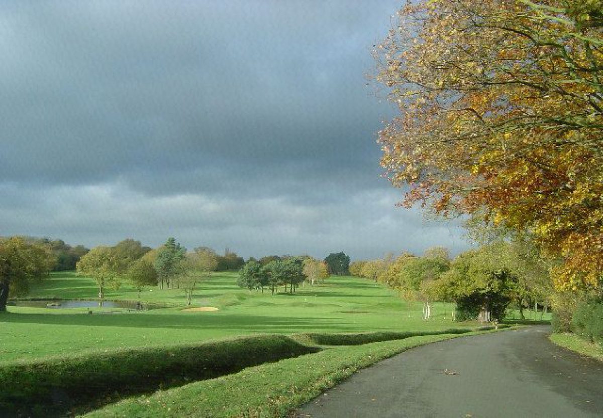
The park encloses the mansion, gardens and pleasure grounds. It is laid out across hilly ground and is now (1999) largely taken up with three golf courses. It retains many mature parkland trees and copses, as well as containing late C20 planting to define fairways. The remains of two avenues to the north-west of the house are aligned on the northern pleasure ground terrace. An informal, largely level, open grass sward extends north-east from the Italian Garden, aligned on the garden front of the house, with views of Watford beyond below the hillside. This may have been an area levelled in the 1720s by Styles in order to open up the view down to Watford, and occupies much of the main axis in Bridgeman's design.
Warburton (surveyed 1720-3, published 1749) shows two avenues aligned on the house, one on the north-east front, and one on the north-west front. Benjamin Styles is said in 1725 to have removed a sizeable hill which obscured the south view from the house at a cost of £5000 (Stroud 1975). Brown's work involved considerable earth moving, as he considered that the surroundings of the house were not sufficiently varied. He endeavoured to remedy this by scooping out more earth in front of the house, and building up some hillocks on either side (ibid). In the late C19 (OS 1878) the remains of three avenues, arranged in the form of a goose foot, extended west and north-west from the house and northern pleasure ground to the park boundary. Traces of further formal lines of trees throughout the park were also evident. A drive called King's Drive (now gone) encircled the hillside west of the mansion, extending north and east to meet the north approach drive close to the park boundary.
KITCHEN GARDEN
The brick-walled kitchen garden lies on the southern boundary of the park, 500m south of the house, adjacent to the west side of Home Farm. The area is divided into three main compartments, now (1999) largely laid to pasture.
REFERENCES
Victoria History of the County of Hertfordshire 2, (1908), pp 375-8
Country Life, 31 (6 January 1912), pp 18(26; (13 January 1912), pp 56-62
C Holme, Gardens of the Southern and Eastern Counties (1907), pls 92, 93
B Cherry and N Pevsner, The Buildings of England: Hertfordshire (1977), pp 251-3
P Hunt and J Willis (eds), The Genius of the Place (1975), pp 97-8
D Stroud, Capability Brown (1975), pp 69-70
G Beard, Thomas H Mawson (1976), p 39
P Willis, Charles Bridgeman (1977), pp 62, 181
J Harris, The Artist and the Country House (1979), p 273
R Strong, The Renaissance Garden in England (1979), pp 141-7
Maps
Dury and Andrews, A topographical Map of Hartford-shire, 1766
A Plan of Moor Park, ... the property of Robert Williams, esqr, 1814, (Hertfordshire Record Office)
OS 6" to 1 mile:
1st edition surveyed 1878
2nd edition published 1899
3rd edition published 1934
OS 25" to 1 mile: 2nd edition published 1899
Description written: March 1999
Register Inspector: SR
Edited: October 2000
- Visitor Access, Directions & Contacts
Telephone
01923 773 146Website
https://www.moorparkgc.co.ukAccess contact details
Please see http://www.moorparkgc.co.uk or telephone 01923 773146
Directions
Two miles from the M25 J18. 1.5 miles south east, off the A4145
Owners
Moor Park Golf Club
- History
The following is from the Register of Parks and Gardens of Special Historic Interest. For the most up-to-date Register entry, please visit the The National Heritage List for England (NHLE):
www.historicengland.org.uk/listing/the-list
HISTORIC DEVELOPMENT
In the 1480s King Edward IV seized The Moor estate from George Nevill, Archbishop of York, who had enclosed c 270ha as a deer park. The estate was one of Cardinal Wolsey's chief residences, it being seized upon his disgrace by Henry VIII and occupied by his queen Catherine of Aragon during their divorce proceedings. Sir John Russell was keeper of the park by 1533, and in 1576 the estate was granted to Francis, Earl of Bedford. From 1617 to 1627 Lucy Harington, Countess of Bedford seems to have 'created [at Moor Park] what was to be a celebrated garden with "very great care, excellent contrivance and ... much cost"' (Strong 1979). The Earl and Countess of Pembroke occupied Moor Park from 1627 to 1630, with further additions to the garden, it being described in detail by Sir William Temple in 1685, some thirty years after he visited on his honeymoon. He referred to it as the 'perfectest figure of a garden' he had ever seen (Hunt and Willis 1975). A new house was built some distance south-west of the earlier mansion in the late C17 by the Duke of Monmouth. In 1720 Benjamin Styles, a merchant who made a fortune from the South Sea Bubble, bought the estate, rebuilding the house and employing Charles Bridgeman (d 1738) to provide a plan for the gardens (Willis 1977).
Admiral Lord Anson (d 1762) bought the park c 1754 (VCH), employing Lancelot Brown (1716-83) from 1753 to carry out extensive works to it during the 1750s, including remodelling the pleasure grounds. The estate passed through several further hands, including Sir Lawrence Dundas, who employed Robert Adam in the house and to design park buildings, and the first Marquess of Westminster who employed Robert Cundy II, and laid out the Italian Garden. Lord Leverhulme employed Thomas Mawson c 1910. In the mid C20 the park was laid out with golf courses and the mansion became the clubhouse, in which use it remains (1999).
- Associated People
- Features & Designations
Designations
The National Heritage List for England: Register of Parks and Gardens
- Reference: GD1164
- Grade: II*
Features
- House (featured building)
- Description: There had been a house on the site in the 16th century, which was replaced by a house on a new site in the late-17th century. The house was re-built after 1720, and the interiors were later re-modelled by Robert Adam.
- Earliest Date:
- Parkland
- Golf Course
- Key Information
Type
Park
Purpose
Recreational/sport
Principal Building
Commercial
Survival
Part: ground/below ground level remains
Hectares
115
Open to the public
Yes
Electoral Ward
Rickmansworth
- References
References
- {English Heritage Register of Parks and Gardens of Special Historic Interest}, (Swindon: English Heritage, 2008) [on CD-ROM] Historic England Register of Parks and Gardens of Special Historic Interest
- Stroud, D., {Capability Brown} (London: Faber, 1975), pp. 69-70 Capability Brown
- Willis, P., {Charles Bridgeman and the English Landscape Garden} (London: Zwemmer, 1977), pp. 62, 181 Charles Bridgeman and the English Landscape Garden
- Harris, J., {The Artist and the Country House} {London: Russell Chambers, 1979), p. 273 The Artist and the Country House
- Holme, C. (ed), {The Gardens of England in the southern and western counties} (London: The Studio, 1907), plates 92 and 93 The Gardens of England in the southern and western counties
- Strong, R. C., {The Renaissance Garden in England} (London: Thames and Hudson, 1979), pp. 141-7 The Renaissance Garden in England
- Pevsner, N. and B. Cherry, {The Buildings of England: Hertfordshire} (Harmondsworth: Penguin, 1977), p. 251 The Buildings of England: Hertfordshire
- Page, W. {Victoria County History: Hertford, Volume 2} ([n.p.]: [n.pub.], 1908), pp. 375-8 Victoria County History: Hertford, Volume 2
- Related Documents
-
CLS 1/797
An Assessment of the impact of the proposed Golf Academy on the setting of Rickmansworth Public Golf Course - Hard Copy.
Debois Landscape Survey Group - 1998
-
CLS 1/798
An Assessment of the impact of the proposed Golf Academy on the setting of Rickmansworth Public Golf Course: Photocopies of Historic Documents - Hard Copy.
Debois Landscape Survey Group - 1998
-
CLS 1/797