Introduction
Latimer Park is a landscape park of 213 hectares, on which Lancelot Brown may have advised. The park originally formed the setting of a country house, but is now in divided ownership. The public park has an educational focus.
Terrain
The site straddles the two sides of the Chess valley.www.historicengland.org.uk/listing/the-list
An C18 park, on which Lancelot Brown may have advised, forming the setting of a country house.
DESCRIPTION
LOCATION, AREA, BOUNDARIES, LANDFORM, SETTING
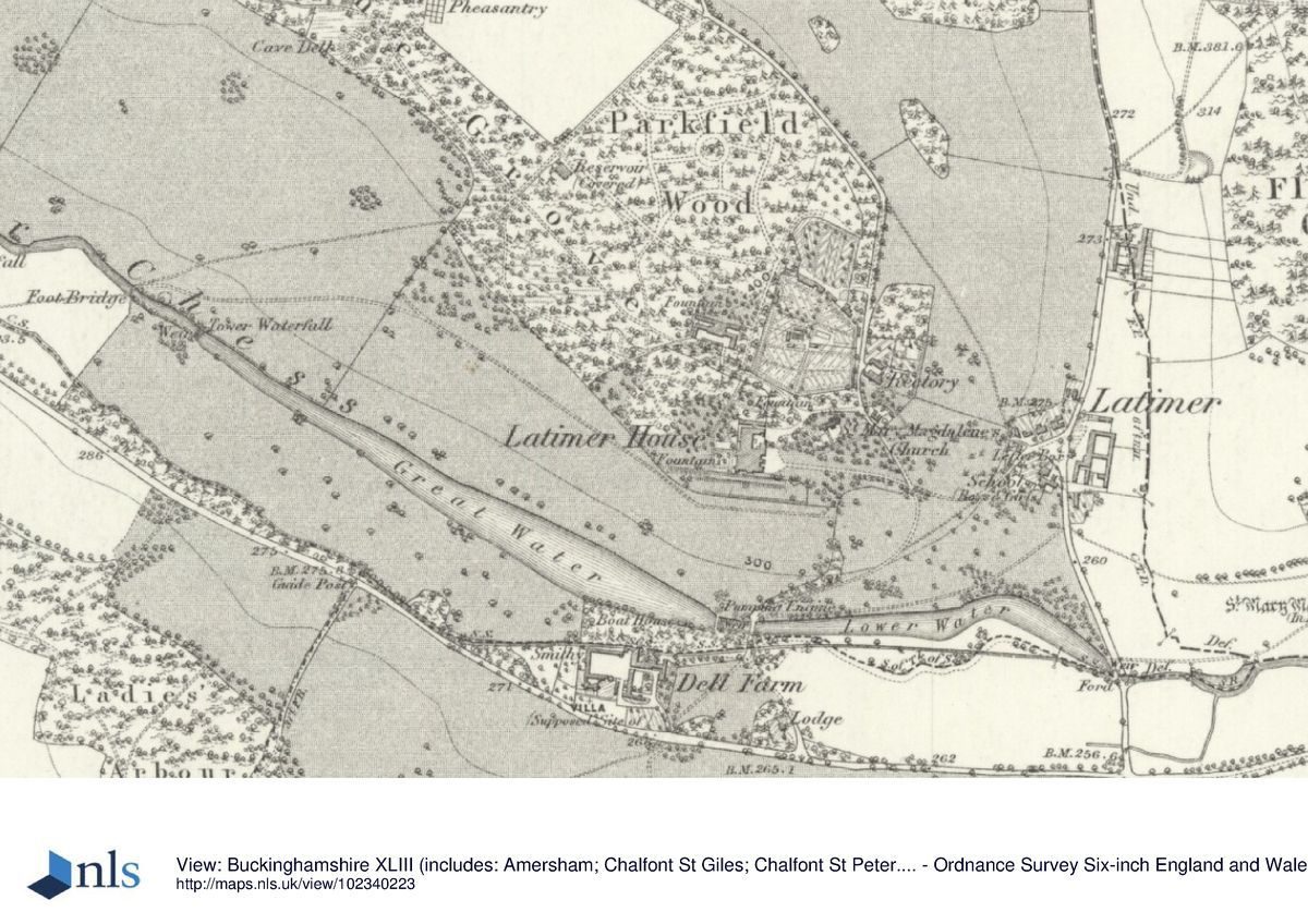
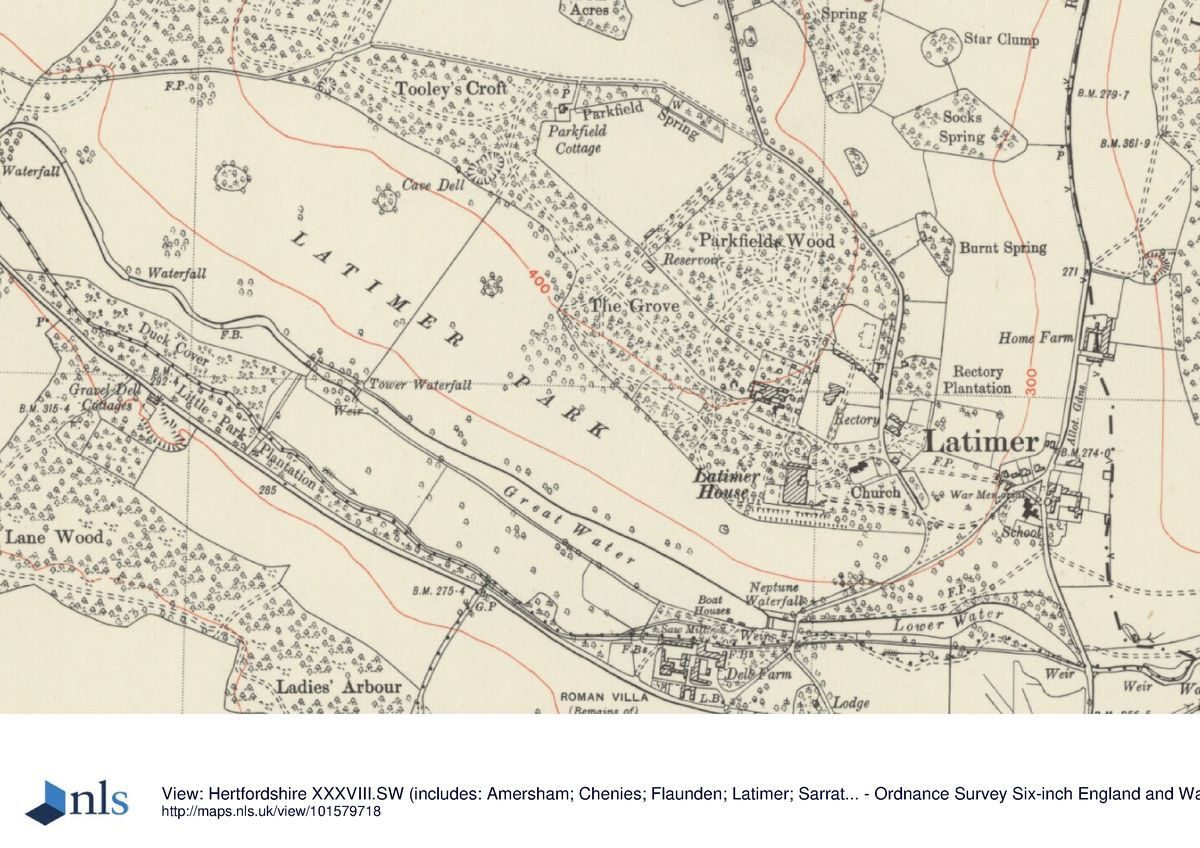
Latimer Park lies 4km north-east of Old Amersham, within the Chiltern Hills on the north side of the River Chess valley. The c 213ha site is bounded largely by agricultural land and woodland, the eastern boundary being marked by Flaunden Bottom lane which runs through the village of Latimer. The site is bisected south-east to north-west by Latimer Road, running roughly parallel with the River Chess which occupies the bottom of the valley, and linking Chenies with Chesham. The site straddles the two sides of the Chess valley, the north-east section extending up the west side of the valley running north from the village. The setting is largely rural, with the adjacent picturesque little village of Latimer surrounding its village green and pump, and, 1.5km to the east along the Chess, Chenies Place (qv) with its Lutyens/Jekyll garden. The land to the east of the Flaunden Bottom road, leading towards Chenies, whilst outside the park, forms an important part of its setting. The C20 development of Little Chalfont lies beyond the south boundary of the site, screened by woodland.
ENTRANCES AND APPROACHES
The main approach to the house is from the east. A drive leads from The Lodge on the Latimer Road to the south, north over a bridge across the Lower Water, and loops up the slope of the park to join with the road from the village of Latimer. From here it continues north along the east side of the pleasure grounds while a short drive branches off and leads west flanked by lawns, past the church screened by evergreens, to the partly enclosed forecourt on the east front. The western part of the village was cleared in the mid C19 so that the grounds could be enlarged in this direction, and to improve the approach.
PRINCIPAL BUILDING
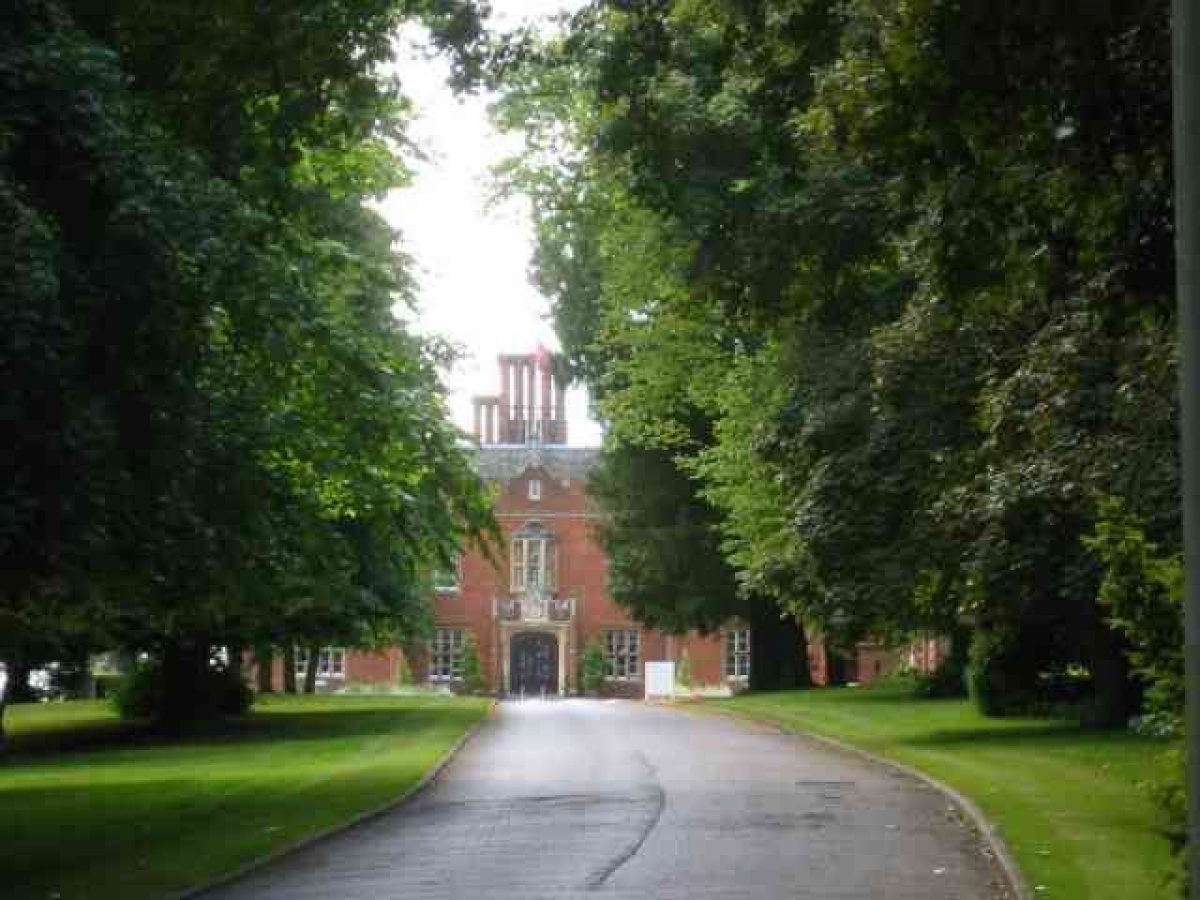
Latimer House (E Blore 1832-8, listed grade II) stands offset eastwards from the centre of the site. Blore's Tudor-style, red-brick mansion replaced an earlier Cavendish mansion. The main rooms overlook the valley to the south, across the park and Great Water, to woods leading up to the top of the hillside opposite. Adjacent to the north lies a large service block surrounding a courtyard (converted to a restaurant, 1990). The red-brick stable block (E Blore 1834(8) lies to the north, outside the registered area.
GARDENS AND PLEASURE GROUNDS
An iron gate leads from the forecourt on the east front to the terrace which runs along the south front. The terrace, constructed in 1863, is supported by a stone and flint checkered wall topped by a set of stone urns (listed grade II). Beyond is a grass terrace from which stone steps lead down a steep grass bank to a gravel walk, a further grass terrace separating the gardens from the park.
Nothing remains of the flower garden which lay to the west of the house and, although there are traces of the earlier gardens, including a tiered fountain, there have been major alterations to the garden area to the north of the house, including the construction of modern buildings. The remains of the pleasure grounds, The Grove and Parkfield Wood, lie to the north of the house. Most of the early plantings have gone from The Grove, and the buildings of the National Defence College, plus a ring of new housing, now encircle Parkfield Wood. The Wood was planted on a previously open paddock in the mid C19 and some of the specimen trees remain. This land is outside the area considered to remain of special historic interest.
PARK
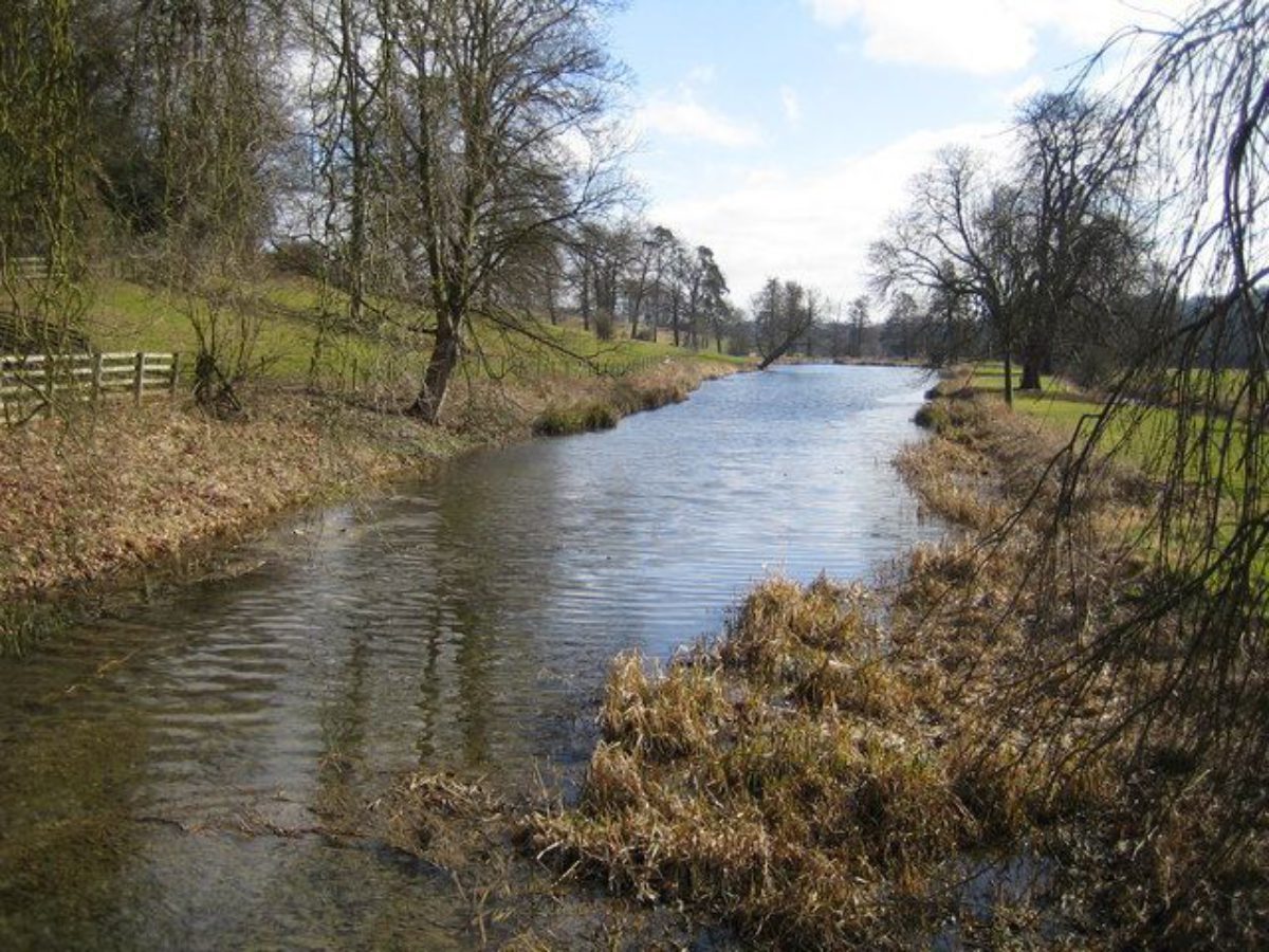
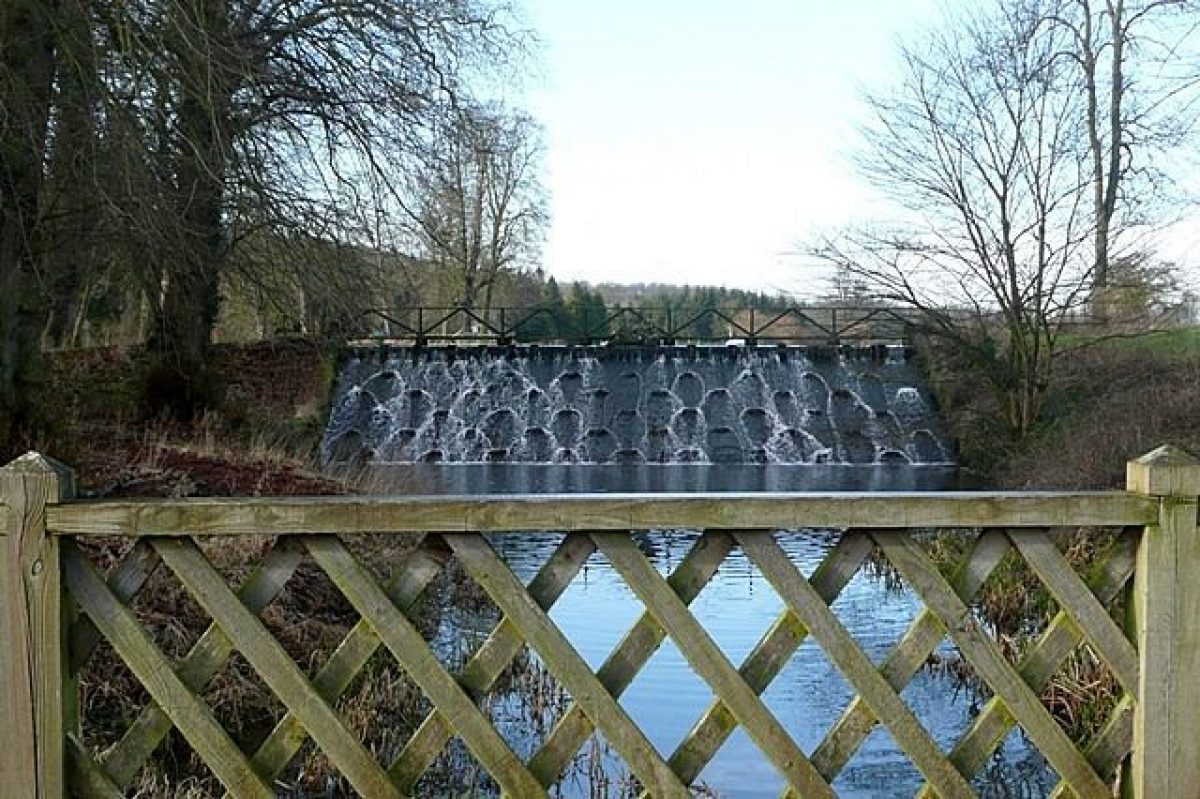
The ground falls steeply south from the house down to the Great Water and Lower Water. Although not shown on Benjamin Capel's map of 1785, these lakes were formed in the 1750s by the damming of the River Chess. The water is held by a great dam, the Neptune Waterfall, which occupies the site of an earlier mill, the level of the Lower Water being significantly below that of the Great Water. A series of five smaller weirs span the river as it runs through the park, of which the Tower Waterfall, marking the western end of the Great Water, is the most significant. The Tower, a folly which accompanied the waterfall, and the Cave, another folly which stood at the west end of The Grove, no longer exist. Hardly surprisingly, nor does the 'Dutch Yacht' which John Lewis, shipwright, was employed to look after. Following the creation of the Water, the mill was beautified on the park side, given a flag-staff, and named 'Latimer Castle', but on the creation of the cascade the building was found to be in the way and in 1763 it was demolished.
The park was enlarged when the lakes were formed, the fields and meadow land above the mill being imparked at this date. George Johnson in his History of English Gardening (1829) praised the design as the work of Lancelot Brown (1716-83) but there is no other evidence to support this. Much of the land is now arable and most of the specimen trees which stood along the banks of the lakes have gone. The park stretches along both sides of the river valley, with woodland closing the skyline on the south side. The Latimer Road runs through the park, parallel to the river. It originally ran to the north of Dell Farm but was diverted round its south side in 1834.
The farm complex on the south side of the east end of the Great Water is prominent in the view across the valley from the south terrace. It belonged to the Chenies estate until 1843 when it was purchased by the Cavendishes who later changed its name from Dell Farm to Home Farm. The name has been recently (1954) changed again to Latimer Park Farm.
The park extends up the west side of the valley which runs north from Latimer village.
KITCHEN GARDEN
The kitchen garden stands to the north of the house and is used as a car park. A substantial new building has been erected within its walls.
REFERENCES
J C Loudon, Encyclopedia of Gardening (1821), p 1233
J Horticulture and Cottage Gardener, 32 (1864), pp 333-6, 347-8; 52 (1874), pp 567-8
D Stroud, Capability Brown (1975), p 231
Latimer Park: Inspector's Report, (English Heritage 1988)
Maps
Estate map, Benjamin Capel, 1785 (Buckinghamshire Record Office)
Plan of the Latimer estate, c 1840 (Buckinghamshire Record Office)
Map of the Latimer estate, 1850 (Buckinghamshire Record Office)
OS 6" to 1 mile:
1st edition surveyed 1876
2nd edition published 1900
Archival items
Diary of Larkin c 1750/60 (transcript copy on EH file)
Description written: February 1999 Amended: April 1999
Register Inspector: SR
Edited: October 1999
- Visitor Access, Directions & Contacts
Access contact details
School parties must pre-book. Telephone 01 494 764342 for details of opening.
Directions
North-east of Amersham, north of Little Chalfont
- History
The following is from the Register of Parks and Gardens of Special Historic Interest. For the most up-to-date Register entry, please visit the The National Heritage List for England (NHLE):
www.historicengland.org.uk/listing/the-list
HISTORIC DEVELOPMENT
The estate was purchased by the Cavendish family in 1615. In the early 1750s it passed to Elizabeth Cavendish and her husband, Richard Chandler, who changed his name by Act of Parliament to Cavendish. They were responsible for re-fronting the house, which for a while became known as Latimer Abbey, and for improvements to the park, during which works much of the old village was demolished. In 1834-8, following a fire, the mansion was rebuilt by Burton and subsequently E Blore, for Charles Compton Cavendish (d 1858), first Lord Chesham.
Having been requisitioned for military use in the Second World War, in 1951 the house was purchased from the Cavendish family by the Government. It served as the National Defence College until 1983 when it was sold and converted into a conference centre.
Period
18th Century (1701 to 1800)
- Associated People
- Features & Designations
Designations
Conservation Area
The National Heritage List for England: Register of Parks and Gardens
- Reference: GD1321
- Grade: II
Features
- House (featured building)
- Earliest Date:
- Latest Date:
- River
- Description: River Chess
- Key Information
Type
Park
Purpose
Educational
Principal Building
Recreational
Period
18th Century (1701 to 1800)
Survival
Part: ground/below ground level remains
Hectares
213
Open to the public
Yes
Civil Parish
Latimer
- References
References
- {English Heritage Register of Parks and Gardens of Special Historic Interest} (Swindon: English Heritage 2008) [on CD-ROM] Historic England Register of Parks and Gardens of Special Historic Interest
- Stroud, D {Capability Brown} (1975) p 231 Capability Brown