Introduction
Kyre Park is a deer park of medieval origin. There is a separate landscape park around the house, including several lakes.
www.historicengland.org.uk/listing/the-list
Later 18th-century pleasure grounds, notably a chain of pools with winding walks and shrubbery, associated with a country house. Adjoining the pleasure grounds around the house is a former deer park with medieval origins.
DESCRIPTION
LOCATION, AREA, BOUNDARIES, LANDFORM, SETTING
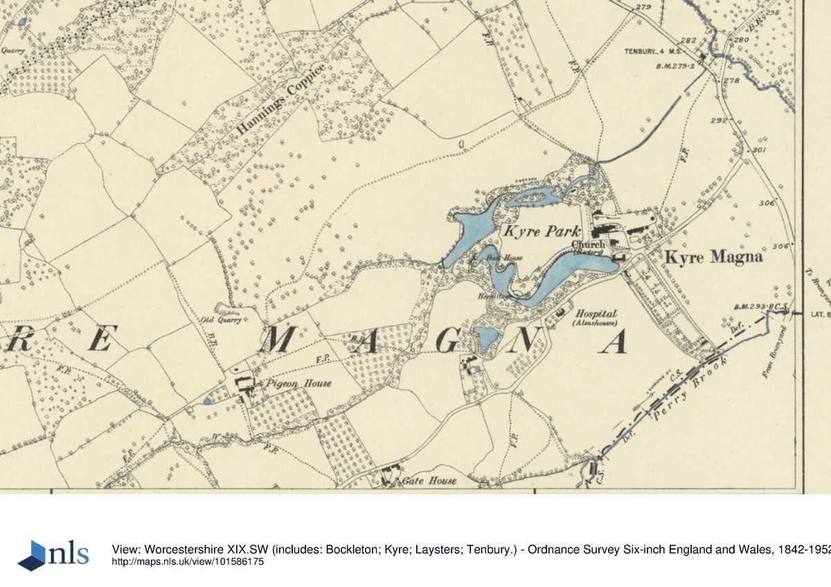
Kyre Park lies on the west side of the B4214 Tenbury Wells to Bromyard road, c 5km south-east of the former and 9km north of the latter. The house, and its home farm complex, adjoin the parish church of St Mary, with views west across the pleasure grounds and north, across the valley of the Kyre Brook, to Kyre's ancient deer park. The registered area is c 169ha, of which c 115ha comprises the former deer park.
ENTRANCES AND APPROACHES
Kyre Park house is approached from the south via a short drive off a minor road, that drive also serving St Mary's church.
In the C18 and for most of the C19 the above approach was the only one to Kyre Park house. Between 1880 and 1890, however, a new drive was contrived, which approached from the north-east, from opposite the C18 lodge on the edge of the deer park. The drive was subsequently lined with silver birches. These survived in the later 1990s although by then the drive was disused.
PRINCIPAL BUILDING
What survives of the historic house (listed grade II) is a medieval west wing with an C18 front to the south of seven bays and two-and-a-half storeys. The staircase is of c 1754, when the medieval and early C17 house was remodelled for Sir Edmund Pytts by the leading Warwick builders William and David Hiorne. It is this portion of the house that overlooks the pleasure grounds. Further restorations and extensions took place 1880-93. In 1934-8 the eastern, Elizabethan, portion of Kyre Park was demolished and replaced by a new structure, in brick and in the Georgian style. In the mid and later C20 the interior was largely stripped of historic features.
Immediately to the south of the house, and linked to it by a pentice, is the medieval parish church of Kyre Magna, St Mary's (listed grade II*). South of the church is the stables range of the 1750s, converted to flats in the C20, while to the east of the house is large brick barn (listed grade II) of c 1618 (again considerably altered in C20) and a circular stone dovecote (listed grade II*) of c 1600 or earlier. Until the early 1750s a pigeon house stood on an island in a pond south of the house; tradition states that in 1756 it was moved to this location.
GARDENS AND PLEASURE GROUNDS
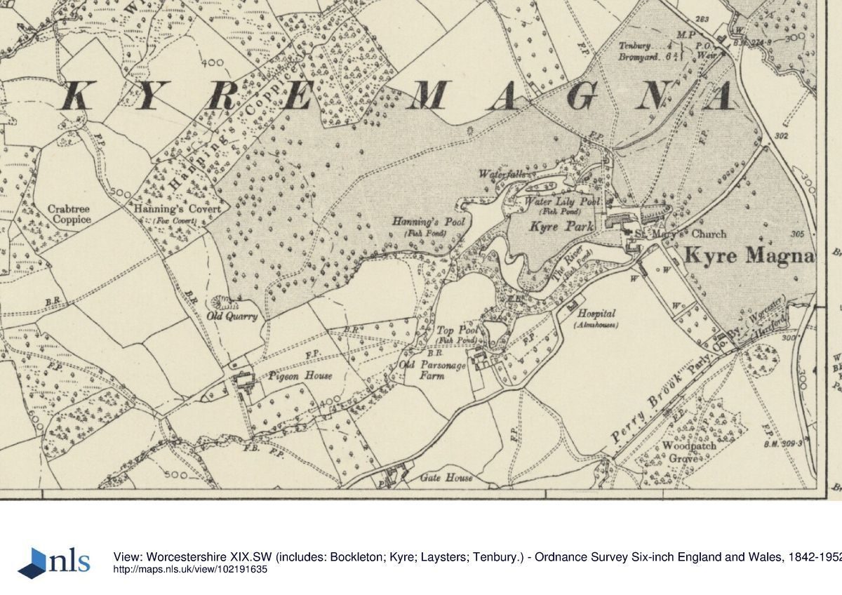
The pleasure grounds, or The Shrubbery , comprise walks and plantings around a circuit of five pools looping west from the house. These envelop a 200m long lawn or meadow which slopes gently away from the house.
An anticlockwise circuit of The Shrubbery moves west, from the tarmac forecourt on the north side of the house, through a wrought-iron gate of the 1880s in an archway through a probably C17 brick court wall, before turning due north. Here the circuit passes down the west side of the brick court wall on a broad, straight, gravelled promenade, on the west side of which is a heather garden on the site of the Victorian parterre. Slightly further into The Shrubbery are the brick footings of an C18 bathhouse. The promenade leads downhill for c 75m, entering The Shrubbery (here planted with many ferns) above the first of the pools, the narrow Fish Pond. This is crossed by a cast-iron C18 bridge set on the foundations of an older brick and stone bridge, perhaps constructed in the later C18. Once across the bridge the path leads north for c 30m before turning south-west to a partially collapsed tunnel. Cut into the naturally occurring bands of sands and gravels, the tunnel led west for c 30m before turning sharply south, to give a view from its portal across the eastern part of the second pond, the Water Lily Pool. The path leads along the north side of this pool, which is c 120m long and with an island, passing towards its west end a series of three waterfalls or cascades which brings water into it from the next pool, Hanning's Pool, which is several metres higher. This manipulation of water from one level to another, with waterfalls, cascades, channels and footbridges all built with knobbly, rustic stonework, is one of the main linking themes of the structure of The Shrubbery. The path crosses the dam at the east end of Hanning's Pool before carrying on along its south side, past dark plantings of predominantly mature yews, through which runs a narrow artificial waterfall or cascade bringing water down some 10m from the north end of The River, the fourth and largest of the pools. The River itself is fed via a cascade of grotto-like form which carries water down from the fifth pool, the triangular Top Pool. That itself is supplied by water piped from the valley of the Perry Brook c 1km away. The western part of The River, overall some 500m long, has an irregular, lobed plan, while its eastern half, which bounds the lawn west and south of the house and is overlooked from its west and south fronts, is straighter and broader (up to 50m). Several structures lay along The River. On the north bank of its west end is the site of a boathouse, opposite a small island. Midway along the south side is a ruinous stone structure, circular in plan and with a diameter of c 3m. North-west of this a wooden bridge of the 1990s, a replacement of an impressive stone and iron structure shown on late C19 photographs (its rails perhaps those now part of the bridge north of the Promenade), crosses a narrowing of The River to its north bank, and the semi-ruinous Hermitage, the exterior walls of which are rustic stonework. C19 photographs show it to have had a gothick facade and a thatched roof.
Dense planting, 30m wide, runs along the whole of the south bank of The River, forming a backdrop to the view of it from the house. The path through it follows a sinuous line; at one point a view is obtained of Pytts Almshouses (listed grade II), an attractive U-plan group of brick buildings of 1716 which lies immediately outside the registered area. Just beyond that, and on the north side of the path, is a mound, perhaps the site of another collapsed building.
The one other garden of note at Kyre is a sunken lawn running along the north side of the barn of c 1618 and with the dovecote at its east end. This is presumably the Archery Lawn referred to in 1893 (Hereford Times).
The pleasure grounds at Kyre were embellished in the second half of the C18. In 1917 (CL) it was said that during the time of Edmund Pytts (succeeded 1752, d 1781), formal gardens and outbuildings occupying two courts to the south of the house were swept away as a part of the improvements to the house and its surrounds. Surviving accounts (WRO) specifically mention under 1754 a bridge with Chinese-style rails, and an octagon summerhouse with cellar, although the latter was at 'Kyre Common', and not within the pleasure grounds. A description of Kyre published in 1868 (Noake) claims that Lancelot 'Capability' Brown was involved in the improvements to the grounds, but no evidence to substantiate that claim is known. A plan of c 1774 shows the grounds to have then comprised the lawn or meadow ('Brick Kiln Meadow') west of the house with a sinuous, S-shaped pool, the later River (in 1774 called 'Water'), bounding it to the south. Perhaps in the 1780s or 1790s this landscape was expanded and planted up to create, essentially, what is to be seen in the late C20. John Davenport, the Shropshire nurseryman and designer, was involved as contractor and/or designer; a letter of June 1784 (in Hereford Record Office: reference supplied by D Whitehead) noting 'I am now Imployed at Mr. Pytts at Kyre and have been for many years and we never had any disputes in settling acts. Or in any other business'. Not all the features survive; documentary sources mention a bridge across the River, perhaps the Chinese bridge mentioned elsewhere.
PARK
Kyre's former deer park lies on the high ground about 1km north-east of Kyre Park house. A brick lodge (listed grade II) of mid C18 date lies on the south-western boundary of the park. It is of two storeys and three bays, the central bay projecting and with pedimented gable above.
The main feature of the park, Kyre Pool, a 500m long piece of water in its northern part, was created or enlarged c 1583. A smaller pool lies 400m to its west. In the late C20 the interior of the park was a mixture of farmland and commercial (largely coniferous) woodland. Only a very few older trees were to be seen, and the landscape's parkland character had been lost.
A deer park was created at Kyre by grant of 1275. In the C16 and later it was famous for its oaks and may have been as extensive as 500 acres (208ha) before reduction by the later C18 to 180 acres (75ha). It remained that size in the late C19 when there was still a herd of fallow deer.
KITCHEN GARDEN
As part of the improvements after 1753 Edmund Pytts walled in a kitchen garden south of the road which bounds the pleasure grounds and home farm to the south. It measures c 140m north/south by 55m east/west and runs downhill from north to south. The brick walls (listed grade II) are up to 3m high (although generally lower) with buttresses every c 12m and are capped with clay copings and stone flags. Built in to the north-west corner of the garden walls is a two-storey brick gardener's house (listed grade II) of the same date, and along the northern part of the west walls some single-storey brick sheds of probably C19 date. The interior of the garden was used for miscellaneous horticultural and craft purposes in the later 1990s.
Before 1753 the kitchen garden apparently lay south of the house; in 1905 a note at Kyre in Jonathan Pytts's handwriting detailing his alterations to the house allowed it and other features of the pre 1753 layout to be located with some accuracy.
REFERENCES
J Noake, Guide to Worcestershire (1868)
Hereford Times, 2 and 9 September 1893
J Amphlett (ed), The Kyre Park Charters (1905)
Worcester Diocesan Architectural and Archaeological Society 28, (1905), pp 792-7
Country Life, 41 (17 March 1917), pp 252-8; (24 March 1917), pp 276-83
The Victoria History of the County of Worcester 4, (1924), pp 279-83
P Reid, Burke’s and Savills Guide to Country Houses: Volume II, Herefordshire etc. (1980), pp 214-15
Maps
OS 6" to 1 mile: Worcestershire sheet 19 SW, 1st edition published 1884
Worcestershire sheet 19 SE, 1st edition published 1885
OS 25" to 1 mile: Worcestershire sheet 19.14, 1st edition published 1885
Archival items
Sale particulars, nd (AA3/8), (Herefordshire Record Office)
Survey with plans of Kyre by Nath Kent, 1772-4; Accounts 1752-61, 1776-84 (Worcestershire Record Office; copies at Kyre Park)
- Visitor Access, Directions & Contacts
Directions
Four miles south-east of Tenbury Wells via the B4214.
- History
The following is from the Register of Parks and Gardens of Special Historic Interest. For the most up-to-date Register entry, please visit the The National Heritage List for England (NHLE):
www.historicengland.org.uk/listing/the-list
The manor of Kyre Wyard was sold in 1575 by Lord Compton to Edward Pytts, an officer of the Court of Common Pleas. It then descended in the Pytts family for over 250 years, especially significant being the periods when it was owned by Edmund Pytts, Member of Parliament for Worcester 1753-61 and sheriff 1771, who inherited in 1752, and his brother Jonathan (died 1807), to whom he made over the property some time before he died in 1781. In 1832 it reverted on the death of Jonathan's widow to his second cousin William Lacon Childe of Kinlet (Shropshire), Member of Parliament. On his death in 1880 Kyre passed to his fifth son, the Reverend Edward Baldwyn-Childe (died 1898). In the 1930s, following the death of Mrs Baldwyn-Childe, Kyre was purchased by the Earl of Clarendon, subsequently passing to Birmingham Council and later to the Spastics Society (1965), before returning in 1993 to private ownership.
Period
- 18th Century (1701 to 1800)
- Late 18th Century (1767 to 1800)
- Associated People
- Features & Designations
Designations
The National Heritage List for England: Register of Parks and Gardens
- Reference: GD1886
- Grade: II
Features
- Dovecote
- Lake
- Kitchen Garden
- Walk
- Description: Winding walks.
- Shrubbery
- Key Information
Type
Park
Purpose
Ornamental
Principal Building
Domestic / Residential
Period
18th Century (1701 to 1800)
Survival
Extant
Hectares
169
Open to the public
Yes
Civil Parish
Tenbury
- References
References
- {English Heritage Register of Parks and Gardens of Special Historic Interest}, (Swindon: English Heritage, 2008) [on CD-ROM] Historic England Register of Parks and Gardens of Special Historic Interest
- A Survey of Historic Parks and Gardens in Worcestershire
- Reid, P., {Burke's and Savills Guide to Country Houses, Vol. 2: Herefordshire, Shropshire, Warwickshire, Worcestershire} (London: Burke's Peerage, 1980), pp. 214-5 Burke's and Savills Guide to Country Houses, Vol 2: Herefordshire, Shropshire, Warwickshire, Worcestershire
- Noake, J., {Guide to Worcestershire} (London: [n.pub.], 1868) Guide to Worcestershire
- Willis-Bund, J. W. {Victoria County History: Worcester, Volume 4} (London: Constable, 1924) pp. 279-83 Victoria County History: Worcester, Volume 4