Introduction
Hoghton Tower is a site of medieval origins, the present house being a 16th-century fortified house with enclosed courtyard and terraced gardens. The gardens occupy about 1 hectare within woodland and parkland of about 15 hectares.
Terrain
On an eminence which rises to 175 metres above sea level.www.historicengland.org.uk/listing/the-list
A series of walled gardens probably of 17th-century origin, a restored 17th- or early 18th-century avenue and Victorian pleasure grounds. The antiquarian interests of the de Hoghton family are reflected in the sympathetic Victorian restoration of the earlier work.
DESCRIPTION
LOCATION, AREA, BOUNDARIES, LANDFORM, SETTING
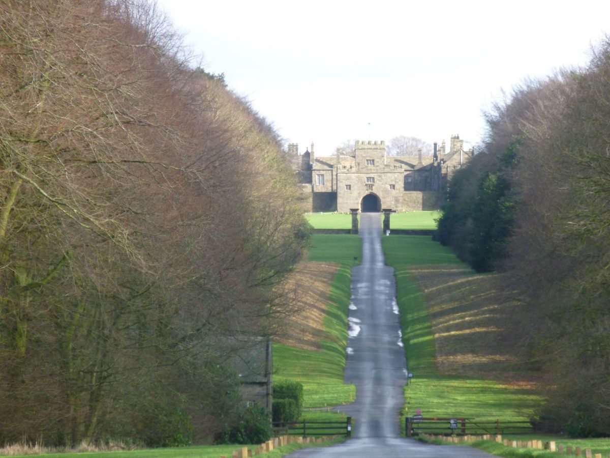
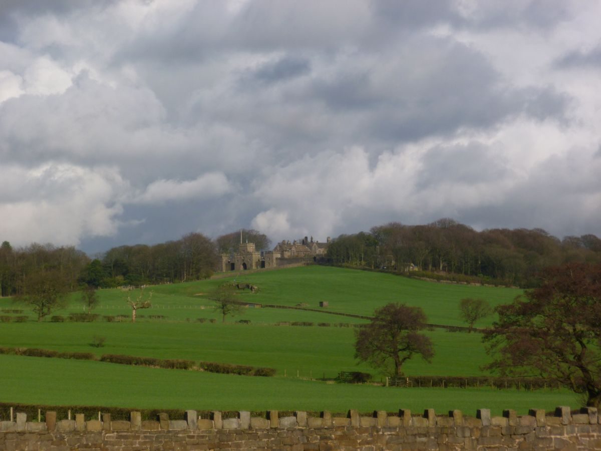
Hoghton Tower is situated between Preston and Blackburn c 1km east of the village of Hoghton. The Tower is on an eminence which rises to 175m above sea level. It is the highest point in the immediate area enjoying long views in all directions and forming a prominent local landmark. The Blackburn & Preston Railway, built in the years following 1844, runs along the north side of the site. The River Darwen is on the east side of the site, passing through a steep gorge called The Horr c 600m east of the Tower. The setting is rural and agricultural. The boundaries of the site are formed by a roughly crenellated stone wall to the north-west which continues along part of the northern boundary to Tower Quarry (disused). The edge of the quarry forms the remainder of the northern boundary. There is fencing along the edge of woodland on the south-eastern boundary, and the south-western boundary is walled along both the edge of the terraced gardens and the Tilting Ground, to the west of the Tower. The boundary extends south-west of the Tower to include a broad avenue which runs from the Tilting Ground to Hoghton Lane.
ENTRANCES AND APPROACHES
The present principal entrance is via a drive running east from Hoghton Lane. There are gates with stone gate piers at the entrance and an avenue leads up a steep hill, framing views of the Tower. This drive was reinstated in the 1860s by Sir Henry Hoghton on the line of a double avenue shown in a painting of 1736 by Arthur Devis (Harris 1979). An avenue is also shown on Yates' county map of 1786. The line of the avenue conforms broadly with the pattern of field boundaries shown on the Tithe map of 1841, suggesting that sufficient physical remains survived for an accurate reconstruction to be made. The main entrance in 1841 was from a drive called Green Lane, which ran north from what is now the junction of Riley Green Switch Road and Bolton Road, and approached the Tower from the south-west corner of the forecourt on the west side. This drive exists as a track which now joins the main drive immediately west of the forecourt. Back Drive, which was the coach drive, branches north-east from the main drive c 300m east of Hoghton Lane; it then runs parallel to the main drive and leads to the stables. There is a C19 stone lodge at the junction of the drives. An area known as Park Gates c 300m north of the main entrance may have been the original coach drive entrance.
There are two other entrances to the site, both situated on the north side. A path runs across fields south from Chapel Lane to an entrance in the boundary wall c 250m north-west of the Tower. A gateway leads to Tower Quarry c 100m north of the Tower and a path branches from the approach to the quarry and runs south into the grounds.
PRINCIPAL BUILDING
Hoghton Tower (listed grade I) was constructed for Thomas de Hoghton c 1560-5, replacing an earlier building on or near the site. It is shown, on top of the hill, on Saxton's county map of 1577. The Tower was damaged in 1643 by Parliamentarian forces and Sir Charles Hoghton Bt undertook a campaign of building during the period 1692-1702. Following the death of Sir Henry Hoghton Bt in 1768, the estate passed to his nephew, who rented out parts of the Tower to farmers. In 1862 Sir Henry Hoghton Bt began a campaign of restoration, using the Lancaster firm of architects Paley & Austin. The work was continued under Sir Henry?s brother, Charles, and was finally completed in 1901 by R D Oliver. The Hall is in use (1997) as a private residence.
The Tower is built on a double courtyard plan. The gatehouse on the west side is linked to flanking towers by a screen wall. A central entrance leads to the outer (service) courtyard which has a formal approach to the inner courtyard formed by steps up to an elaborate wrought-iron gate between gate piers which is aligned with the gatehouse entrance. A path, which runs between stone piers with ball finials and is flanked by lawns, leads through a walled quadrangle and thence to an arched entrance leading to the inner courtyard, which is flagged. Some 40m north-west of the Tower is a coach house and stable (C17, listed grade II). Some 30m west of this is the Great Barn (listed grade I), dated 1692.
GARDENS AND PLEASURE GROUNDS
On the west side of the Tower there is a forecourt called the Tilting Ground. The main drive leads into this area through tall gate piers (?C18, listed grade II) flanked by walls with secondary gate piers, and continues to the gatehouse. The latter, with its screen wall, forms the east side of the area. The south side is walled and the Great Barn gives closure on the north side. The Tilting Ground is grassed, and appears much as it is shown in the 1736 painting (Harris 1979).
To the east of the Tower there is a rectangular walled garden called the Wilderness. The walls, apart from the south wall, which is stepped down and has a flat parapet, are crenellated. There are entrances at the mid-points of the north, east and south walls. That in the north wall is a doorway with an arched head, and opposite on the south side there are gates between stone gate piers. The entrance on the east side is a doorway with a flat head. At the north-east corner there is a crenellated tower with steps up to a rooftop viewing platform, giving views in all directions. Rough stone footings at the base of the tower and masonry exhibiting variation in wear and finish suggest the tower retains pre-Victorian fabric. The east side of the Tower forms part of the west side of the garden and a door is situated in a short wing, known as the East Wing, projecting to the south from the main building with a stairway leading down to the garden. This feature gives access from a suite of upper-floor rooms. A wall continues from this wing and forms the remainder of the west side of the garden; it has a doorway leading through to another, smaller, walled garden on the south side of the Tower, called the Rose Garden.
The Rose Garden is situated in the angle of the south side of the Tower and the projecting East Wing. The south wall is crenellated and the entrance from the Wilderness, in the eastern wall, is aligned with a doorway in the crenellated west wall. There is an avenue of clipped yews linking the two. A balustraded walk of C19 date runs parallel to the Tower along part of the north side of the garden. To the west of the Rose Garden is the Rampart Garden. This is rectangular, with the Tower forming the north side and crenellated walls on the other sides. This garden extends southwards from the line of the Wilderness and the Rose Garden. There are two entrances in the east wall, one at the south-east corner of the garden with gate piers leading from a terraced walk, called the Long Walk, the other being the doorway leading from the Rose Garden.The latter opens onto a terraced walk along the east side of the garden which is reached from steps up to an arcaded stone pavilion in the north-east corner and from steps up from the Long Walk entrance. Another terraced walk runs along the western edge of the garden. Steps lead up to a viewing platform on the roof of a crenellated tower at the south-west corner of the garden, which links with the walk which runs north to a platform at the north-west corner, also with steps leading up to it. Extensive long-distance views are obtained westwards from the walk and viewing platforms.
The west wall of the Rampart Garden connects with the southern of two embattled towers which flank the gatehouse at the west front of the Tower, and it forms part of the screen along the west front as shown in the 1736 painting. Stonework visible along the base of the wall and the viewing tower is more worn and roughly finished than the stonework above.
Most of the crenellated tops and part of the fabric of the walls around this series of enclosed gardens appear to date from the mid-Victorian restoration, but they all exhibit masonry which varies in wear and finish. The gardens conform closely in plan to what is shown on the 1841 Tithe map and the 1st edition OS map surveyed 1845, before restoration had taken place. The exception is the boundary between the Wilderness and the Rose Garden which is shown on a line east of the southern projecting wing so that the whole of the wing was within the area of the Rose Garden. The 1736 painting shows the west wall of the Rampart Garden, as does a water colour of 1816-17 by J C Butler (guidebook 1992).
The Long Walk leads from a gateway on the north side of the outer courtyard and runs along the north side of the Tower where a wall surmounted by railings divides it from a precipitous drop. The walk continues and runs around the outside of the Wilderness, turning south and then west to continue along the outside of the Rose Garden. A gateway leads into the Rampart Garden and the walk skirts the edge of this garden and emerges through an archway to connect with a drive running along the west front of the Tower. There are views across wooded slopes to the countryside beyond from this walk. This walk is broadly as it is shown on the 1845 OS map.
On the south side of the Tower a series of terraces runs down the slope. The western edge of this area is defined by a stone wall on the east side of a track leading south from the Tilting Ground, which is suggested on the 1736 painting. The main access to the terraces is from the Long Walk, at the point at which a gateway in the south wall of the Wilderness leads to steps running southwards down the slope to a platform with low stone walls on the terrace below. On each side of the platform ramps lead southwards down the slope to a terrace beneath this. A path leads along the terrace and down to a further wide terrace with the remains of tennis courts. Beneath this is one more terrace, which is formed by a stone retaining wall which is connected with a wall on the west side and returns as a retaining wall along the east side. The upper terraces have traces of paths along them. The line of the second terrace conforms with a boundary shown on the Tithe map of 1841, suggesting that C18 landscaping may be incorporated into the terracing; there is some suggestion of a terrace planted with trees in this position in the 1736 painting.
The slopes of the hill on which the Tower is situated are wooded on all but the south-west side. Most of the planting appears to post-date the Devis painting which shows that the hillside was bare when viewed from the west; however it conforms well with the extent of tree-cover shown on the 1841 Tithe map.
KITCHEN GARDEN
A walled kitchen garden is situated c 80m west of the Great Barn. It is of sub-rectangular shape with recesses at the mid-points of the west and south walls. There is a pavilion with a gabled roof and columns in the south-west corner of the garden, and gate piers of C19/early C20 date are situated at the south-east corner. The garden does not appear on the large-scale OS map of 1893, but it is shown on the 1929 map. The area is now used as a car park.
REFERENCES
N Assheton, Assheton's Journal (1617),
Chethams Society 14, (1848), pp 38-41
Country Life, 17 (11 February 1905), pp 198-206; (18 February 1905), pp 234-40; no 30 (23 July 1992), pp 82-5; no 31 (30 July 1992), pp 50-3
The Victoria History of the County of Lancashire 6, (1911), pp 36-46
Hoghton Tower, guidebook, (G C Miller 1948)
N Pevsner, The Buildings of England: North Lancashire (1969), pp 144-5
J Harris, The Artist and the Country House (1979), p 247, pl 284
Hoghton Tower, guidebook, (F Singleton 1992)
Maps
C Saxton, Lancastria Comitatus Palatin Vera et Absoluta Descriptio, 1577
W Yates, The County Palatine of Lancaster, 1786
Tithe map for Hoghton, 1841 (Lancashire Record Office)
OS 6" to 1 mile:
1st edition surveyed 1845, published 1848
provisional edition, revised 1929 with additions 1938
OS 25" to 1mile: 2nd edition surveyed 1892, published 1893
Description written: February 1997 Amended: June 1998
Register Inspector: CEH
Edited: March 1999
- Visitor Access, Directions & Contacts
Telephone
44 1254 852986Website
https://www.hoghtontower.co.ukAccess contact details
The site is open July, August and September. Sunday - 1pm to 5pm. Mon/Thurs 11am to 4pm. Check for events and bank holiday opening. Please see: http://www.hoghtontower.co.uk/day-visitor.html or telephone 01 254 852986
Directions
6 miles east of Preston on the A675. Please see: http://www.hoghtontower.co.uk/contact.html
- History
The following is from the Register of Parks and Gardens of Special Historic Interest. For the most up-to-date Register entry, please visit the The National Heritage List for England (NHLE):
www.historicengland.org.uk/listing/the-list
HISTORIC DEVELOPMENT
The de Hoghton family has owned land in the area since the 12th century or earlier. The family descends directly from Harvey de Walter, a companion of William the Conqueror, and the de Hoghton name was first assumed in 1150. The enclosure of 500 acres of land for a park at Hoghton is recorded in a charter of 1337 and a licence for the enlargement of the park was granted to Richard de Hoghton in 1386. King James I stayed at Hoghton Tower for three days in 1617 during which time he hunted in the park. The exact boundaries of the historic deer park are unclear but they probably included Hunter's Hill, about 1 kilometre to the north of the Tower, and the nearby sites of Lower Park Farm and Higher Park Farm. King's Hill, which is about 600 metres east of the Tower, was probably named to commemorate James I's visit. Possible boundaries of the deer park are suggested by the following features: a stone wall, called King Stephen's Wall, which stretches northwards from Pleasington Golf Course to Alum House Wood, about 2 kilometres north-east of the Tower; a dyke running along the edge of a stretch of ancient woodland called Wild Bottoms Wood, west of this; a lane running north from Chapel Farm to Bolton Hall, and the line of a track continuing north of Bolton Hall to Wild Bottoms Wood. The estate has remained in the continuous ownership of the de Hoghton family.
- Associated People
- Features & Designations
Designations
The National Heritage List for England: Register of Parks and Gardens
- Reference: GD1945
- Grade: II
Style
Tudor-Style Garden
Features
- Lawn
- Topiary
- Fountain
- Mixed Border
- Sculpture
- Drive
- Fortified Manor House (featured building)
- Earliest Date:
- Latest Date:
- River
- Description: The River Darwen is on the east side of the site.
- Boundary Wall
- Description: The boundaries of the site are formed by a roughly crenellated stone wall to the north-west.
- Avenue
- Key Information
Type
Garden
Purpose
Ornamental
Principal Building
Domestic / Residential
Survival
Extant
Hectares
15
Open to the public
Yes
Civil Parish
Hoghton
- References
References
- {English Heritage Register of Parks and Gardens of Special Historic Interest}, (Swindon: English Heritage, 2008) [on CD-ROM] Historic England Register of Parks and Gardens of Special Historic Interest
- Harris, J., {The Artist and the Country House} (London: Russell Chambers, 1979), p. 247, plate 284 The Artist and the Country House
- Hartwell, Clare and Pevsner, Nikolaus {The Buildings of England: Lancashire : North} (London: Yale University Press, 2009) The Buildings of England: Lancashire : North
- Farrer, William {Victoria County History: Lancaster, Volume 6} ([n.p.]: [n.pub.], 1911), pp. 36-46 Victoria County History: Lancaster, Volume 6