Introduction
The site contains 17th-century walled kitchen gardens covering about 2 hectares. These survive from a 17th-century manor house which was destroyed by fire in the 18th century and never rebuilt. The site appears originally to have been associated with an adjacent deer park, which was ornamented with avenues in the 17th or early-18th century. There are also the 19th-century gardens around the 18th-century hunting lodge. The whole covers an area of about 220 hectares.
Terrain
The site straddles a valley containing fishponds linked by a stream, running south-west to north-east, with the east and west extremities of the park occupying high, largely level ground.The following is from the Register of Parks and Gardens of Special Historic Interest. For the most up-to-date Register entry, please visit the The National Heritage List for England (NHLE):
www.historicengland.org.uk/listing/the-list
The site comprises three elements: the site and garden remains of a 17th century country house burnt down in 1718; an adjacent medieval deer park ornamented with avenues in the 17th or early 18th century which appear to have connected the park with the 17th century gardens and house; and the gardens of Hamstead Lodge, an early 18th century hunting lodge standing at the centre of the park, altered and enlarged in the 19th century, and surrounded by 19th century gardens.
Location, Area, Boundaries, Landform and Setting
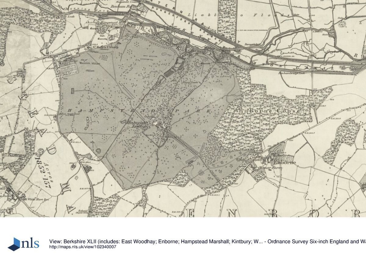
Hamstead Park lies c 5km west of Newbury and 1km north-east of the village of Hamstead Marshall. Formerly the village stood at the north-west corner of the park, east of the church, but at some stage it was moved down the hill to its present site. The 220ha site is bounded to the north largely by the River Kennet and the Kennet and Avon Canal, opened in 1811, to the south-east by the old Newbury to Hungerford road, to the west by Park Lane and on the other sides largely by agricultural land. The site straddles a valley containing fishponds linked by a stream, running south-west to north-east, with the east and west extremities of the park occupying high, largely level ground.
The setting is principally agricultural, with long views south-west and north-west towards the Downs, and views north over the river and Canal towards Marsh Benham and Benham Park (qv), formerly part of the Craven estate lands.
Entrances and Approaches
The main approach enters the park from Enborne, adjacent to the south side of Enborne Copse, curving west through the park to meet, 550m south-east of the house, a horse chestnut avenue aligned on the house. The drive continues north-west along the avenue, entering the pleasure grounds c 80m from the house via a pair of short, stone gate piers (C19) with iron gates, continuing up to the main entrance on the south-east front. Before the construction of the serpentine east arm of this drive (present by 1841), the drive entered further west along the Enborne lane, continuing the axial line of the main section of the drive, this section now being a public footpath.
A further drive enters off the Marsh Benham lane at the north-west corner of the park, 900m north-west of the house, running east through the park and crossing the dam across the north end of the northernmost fishpond before rising up the eastern hillside in serpentine fashion towards the pleasure grounds. The drive skirts the east side of these, passing the former mews, arriving at the main, south-east front of the house. The north-west entrance has been moved from an earlier, now disused entrance adjacent to Hamstead Mill (1811, on the site of earlier structures) aligned on a sycamore avenue which runs straight up the hillside to the south.
The C17 mansion which stood in the north-west corner of the site appears to have been approached from either end of a long, narrow enclosure which ran the whole length of the north side of the house and ornamental gardens (now gone). This had a gateway at each end, and seems to have been divided by an extant pair of piers set into a wall close to the north wing of the house. The main formal approach (Knyff and Kip 1714) seems to have been via the park to the east, between two elaborate brick gate piers (late C17/early C18, listed grade I) with stone dressings and vase finials, standing north-east of the mansion and 30m south of the church. Formerly flanked by walls, these now stand isolated in a field. A further pair of gate piers in similar style (late C17/early C18, listed grade I) stands 100m west of, and aligned with, the eastern pair, these not being shown by Knyff and Kip as the house masked them in the view taken.
The mansion was probably approached by entering the walled forecourt on the west front, only the west wall of which forecourt remains (C17-¿C18, listed grade I). Built of brick panels, the central section curves westwards, with round-arched niches inserted into the wall at intervals. At the centre of the curved section of the wall stand two massive, elaborately carved stone gate piers with vase finials, these, presumably the main west entrance, being aligned with the centre of the former mansion. They seem formerly to have given onto a plain lawn, probably a bowling green.
The west end of the enclosure which ran along the north side of the house still exists, although in modified form, with the former Home Farm buildings (now converted to domestic use, 1998) forming part of the north side and one of the garden walls forming the south side. The west end, formerly entered off Park Lane via a further pair of stone gate piers (probably by William Winde 1660s¿80s, listed grade I) crowned by military trophies, has lost these piers, moved in the C19 to the north-west entrance of nearby Benham Park (qv), off the A4.
Principal Building
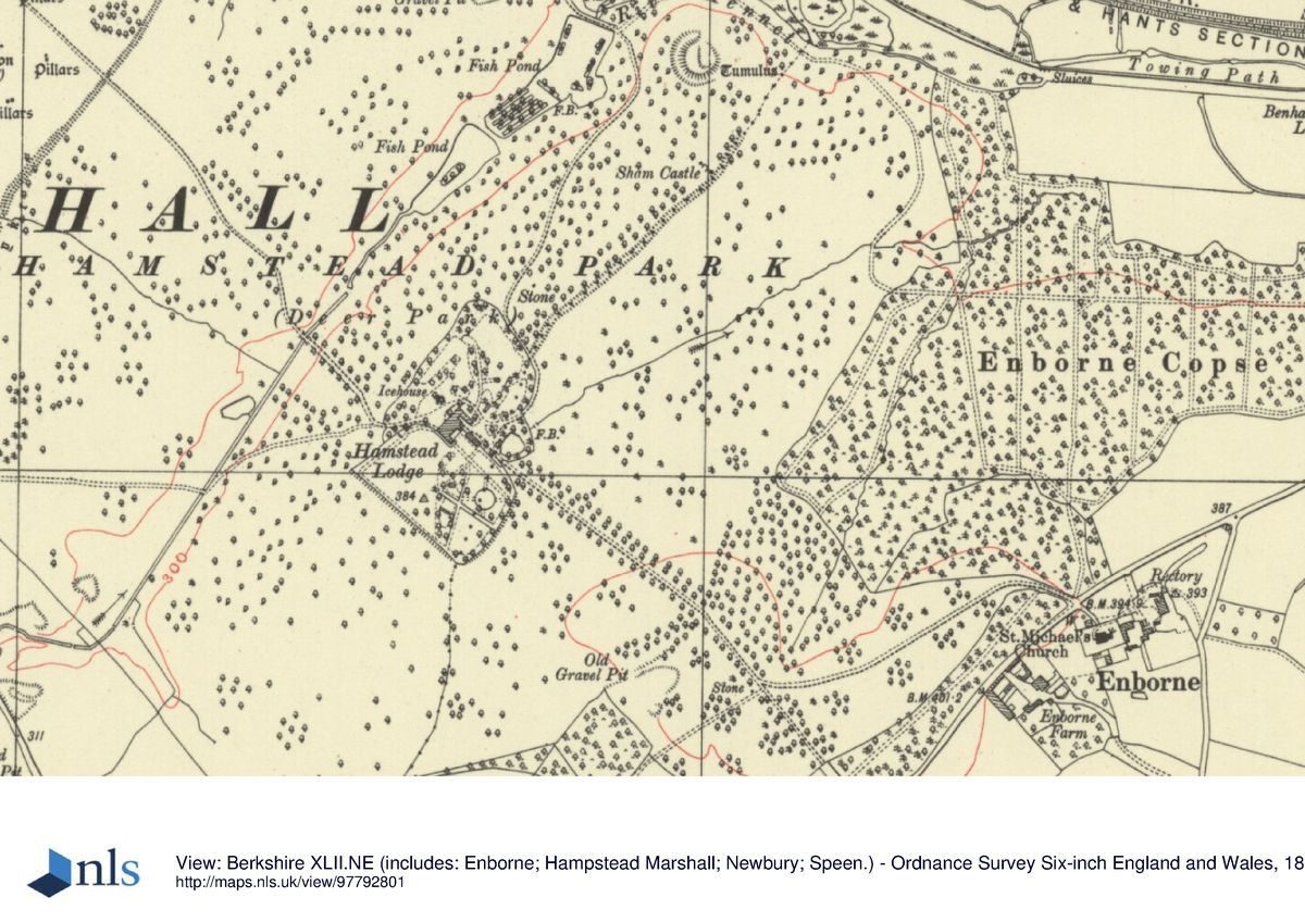
Hamstead Lodge (c 1720, enlarged C19, listed grade II) lies towards the centre of Hamstead Park. Built of two storeys, on a rectangular plan and stuccoed, it has an L-shaped extension to the north. It incorporates a hunting lodge of c 1720, which itself possibly occupied the site of an earlier building.
The former mansion, the only visible traces of which are a depression in an arable field, lay c 900m north-west of the Lodge, sited on a plateau at the north-west corner of the park, towards the east end of a complex of formal garden compartments. It was built for the first Earl Craven, 1663-88, probably incorporating an earlier structure rebuilt by Sir Thomas Parry c 1590. Initially the Earl's improvements were to an early 1660s design by Sir Balthasar Gerbier, the work being completed after his death at Hamstead Marshall in 1663 by William Winde. This house was burnt down in 1718 and the remains gradually removed, although it seems that a new house was begun in 1739 by James Gibbs, but abandoned on Lord Craven's death in the same year.
Gardens and Pleasure Grounds
The gardens of Hamstead Lodge encircle the house, those to the south largely enclosed from the surrounding parkland by a ha-ha, and are mainly of the C19. A series of terraces descends to the north-west, overlooking the valley and with views across to the church on the northern plateau. A central flight of steps descends the terraces to an iron gate into the park, and to either side of the steps the terraces are thickly planted with yew hedging and other shrubs. South-west of the house a lawn contains a large Lebanon cedar, reached via a geometrical, hedged garden containing smaller, formally laid out areas connected by paved paths, and a pedimented doorcase let into one of the hedges. South of the house lies a C19 shrubbery. Adjacent to the south-east front lies a box-hedged parterre sheltered to the east by an elaborate C19 garden wall (listed grade II), incorporating an arched niche over a stone basin, with rooms to the rear, and, beyond to the south-east, a lawn extending as far as an iron railing clairvoie set into the garden boundary, flanked by stone piers. East of this, close to the east drive, lies a small pond, informally planted, and north of this, 50m north-east of the house, stands an octagonal wooden summerhouse (C19, listed grade II) in rustic style, with a verandah.
The former mansion was connected to a series of walled ornamental and productive gardens (Knyff and Kip 1714). On the east front lay a square forecourt laid to lawn with paths and a central star-shaped feature, dominated on the east side by a massive gateway which appears to have flanked a clairvoie (now gone), allowing views into the deer park. Adjacent to the south lay a large, rectangular parterre, the South Court, laid to lawn cut into patterns by paths, and with a large, central circular space. Ribbon borders appear to have been used around the edges of the central lawns. Traces of the outline of this parterre and its beds can be seen from aerial photographs (private collection). The South Court was surrounded by a high wall, with gateways or clairvoies inserted at the centres of the west, south and east sides, the massive piers of which survive (late C17/early C18, listed grade I), elaborately built of brick with stone dressings and finials. Those to the south (possibly by Edward Pierce) and east overlooked the park beyond, that to the east being formerly aligned on an avenue extending east into the park. The west gateway, still set into a brick wall, gives access to the once regularly laid out walled grove to the south-west of the mansion.
The grove, possibly planted with ranks of fruit trees in the early C18 (Architectural Review 1906), retains its boundary walls (C17/C18, listed grade I), although now largely laid to lawn, with a late C20 house inserted at the west end, and a tennis court at the east end. The west boundary of the 150m x 100m rectangular area is formed by the massive, raised, brick-walled terrace (C17/C18, listed grade I), projecting 16m west towards Park Lane at its north and south ends. The 3m high terrace was formerly ascended on the east side via an elaborate double staircase (Knyff and Kip 1714). The top of the terrace, laid to lawn, overlooks the walled former grove to the east, and to the west Park Lane, and beyond this a field which formerly was laid to lawn and surrounded by ranks of trees in formal patterns. The field, latterly used for mineral extraction (C20), retains a bank at the west end. To the north of this stands the brick former dovecote and granary, Ivy House (C16/C17 with later extensions, listed grade II), shown as an isolated building in the early C18 (ibid).
To the north of the former grove lie two brick-walled garden compartments which lay adjacent to the forecourt which stood on the west front of the mansion. The eastern compartment is bounded to the east by the west wall of the former entrance forecourt, with curved central walls, flanking stone piers, projecting westwards into this compartment which appears formerly to have been a bowling green. The western compartment seems to occupy part of the site of a small, formal wilderness, and retains a further central gateway with tall, elaborately carved stone piers (C17/C18, listed grade I) in the west wall, now the entrance to Craven House sited in the former grove compartment.
These compartments were used in the C19 (OS) as kitchen gardens for Hamstead Lodge.
Park
The park, dating from at least the early C13 (VCH 1924), surrounds Hamstead Lodge and its garden, and is laid to pasture, with many mature park trees of a wide range of ages, including many ancient pollards. It is bisected by the valley running south-west to north-east, through which runs a stream, at the north end broadened into a chain of three fishponds, which are probably also C13 in origin. Further C13 features include three mottes situated along the north boundary overlooking the river to the north. The easternmost motte, standing 600m north-east of the Lodge, has a good view of the site of the former mansion, which view may have been focused by a former C17/C18 avenue between the two features (Rocque, 1761; OS 1882). The earthwork remains of a medieval park pale, possibly incorporating earlier earthworks, mark parts of the west and south deer park boundary.
The park was formerly planted with a series of avenues, possibly originating from the C17, and in place by the mid C18 (Rocque, 1761; estate map, 1775), largely aligned on the fronts of the Lodge. Lancelot Brown (1716-83) was employed by Lord Craven in the 1770s to lay out the park at his principal local residence, the adjacent Benham Park. It is possible that Brown advised on the layout of Hamstead Marshall park, and that an unrealised scheme was floated to create a large lake in the river valley to unite Hamstead visually with Benham (Lambert 1996).
A press report of the Great Western Railway Fete of 1858, held at Hamstead Lodge, refers to 'magnificent avenues of chestnut and beech trees leading in various directions', and Betjeman and Piper (1949) refer to an 'immense avenue across grass and bracken slopes' leading to the Lodge from the site of the former mansion; these avenues are also shown in the late C19 (OS 1882) but little or nothing of them now remains.
Kitchen Garden
The walled gardens of the former mansion were reused as the kitchen garden for the Lodge by the C19 (OS 1882), and are now in domestic use. The area lying north of the long, narrow, former entrance enclosure seems to have contained the productive garden during the late C17 and early C18 (Knyff and Kip 1714), bounded to the south largely by brick and timber-framed former farm buildings (C17-C19, listed grade II), now in domestic use, and to the other sides by brick walls. Towards the centre of the north wall stands a further gateway, flanked by two large brick pillars with stone plinth bases and tops (C17/C18, listed grade II*), of less elaborate design than those elsewhere on the site, and having lost their stone finials.
REFERENCES
L Knyff and J Kip, Britannia Illustrata 1, (1714) [reproduced in Country Life and VCH]
Architectural Review 19, pt 1 (1906), p 155
Country Life, 33 (29 March 1913), pp 454-62
Victoria History of the County of Berkshire 4, (1924), pp 178-83
J Betjeman and J Piper (eds), Murray's Berkshire Architectural Guide (1949), p 127
N Pevsner, The Buildings of England: Berkshire (1966), p 152
P Stokes, Craven Country, The Story of Hamstead Marshall (1996)
D Lambert, Hamstead Marshall Landscape Report, (unpublished study for English Heritage (1996)
Maps
Rocque, Map of Berkshire, 1761
Hamstead Marshall Estate Survey, 1775 (D/EC/E11/1), (Berkshire Record Office)
Hamstead Marshall Estate Survey, 1785 (D/EC/E13), (Berkshire Record Office)
OS 6" to 1 mile: 1st edition published 1882
2nd edition published 1913
OS 25" to 1 mile: 2nd edition published 1911
Description written: June 1998
Edited: March 2000
- Visitor Access, Directions & Contacts
Directions
South-east of Newbury
- History
The following is from the Register of Parks and Gardens of Special Historic Interest. For the most up-to-date Register entry, please visit the The National Heritage List for England (NHLE):
www.historicengland.org.uk/listing/the-list
HISTORIC DEVELOPMENT
From the early 13th century the manor was held by the Marshals of England, and at various times members of the Royal Family visited or lived there. The deer park and fishponds date from at least the early 13th century when there was also a substantial dwelling. In 1620 the estate was purchased by Elizabeth Craven, the widow of William Craven, Lord Mayor of London, descending in 1627 to her son William (1608-97), created Lord Craven of Hamstead Marshall. Lord Craven, left enormously wealthy by his mother, rebuilt the old manor house at Hamstead Marshall from the 1660s to the 1680s, probably using William Winde as his architect. Around it he created a grand, formal, compartmented garden, (seemingly accurately depicted in detail by Knyff and Kip in Britannia Illustrata about 1714), possibly linked to the adjacent park by a series of formal avenues (Rocque, 1761), although these may be an early 18th century feature. The house burnt down in 1718 and the site was abandoned, a hunting lodge being built at the centre of the park about 1720 which was developed into the Craven residence in the early to mid 19th century. The new house was surrounded by gardens, and remained the property of the Cravens until the late 20th century. The estate remains (1998) in private hands, with the walled gardens in divided ownership.
- Associated People
- Features & Designations
Designations
The National Heritage List for England: Register of Parks and Gardens
- Reference: GD1504
- Grade: II
Features
- Hunting Lodge (featured building)
- Earliest Date:
- Latest Date:
- Kitchen Garden
- River
- Description: The site is bounded to the north largely by the River Kennet and the Kennet and Avon Canal.
- Canal
- Description: The site is bounded to the north largely by the River Kennet and the Kennet and Avon Canal.
- Fishpond
- Avenue
- Manor House
- Deer Park
- Key Information
Type
Park
Purpose
Ornamental
Survival
Extant
Hectares
220
Open to the public
Yes
Civil Parish
Hampstead
- References
References
- {English Heritage Register of Parks and Gardens of Special Historic Interest} (Swindon: English Heritage 2008) [on CD-ROM] Historic England Register of Parks and Gardens of Special Historic Interest
- Pevsner, N. {The Buildings of England: Berkshire} (Harmondsworth: Penguin, 1966) p152 The Buildings of England: Berkshire