Introduction
Benham Park is a late-18th-century landscape park, designed in 1775 by Lancelot 'Capability' Brown. It covers approximately 150 hectares. The northern half of the park slopes down from the north boundary, with the house sited part way down the slope, overlooking the valley of the River Kennet to the south at the bottom of the slope.
Terrain
The northern half of the park slopes down from the north boundary, with the house sited part way down the slope, overlooking the valley of the River Kennet to the south at the bottom of the slope.The following is from the Register of Parks and Gardens of Special Historic Interest. For the most up-to-date Register entry, please visit The National Heritage List for England (NHLE):
An C18 country house with pleasure grounds and formal C19 garden terraces (possibly by William Andrews Nesfield), surrounded by a landscape park laid out by Lancelot Brown in the 1770s.
Location, Area, Boundaries, Landform and Setting
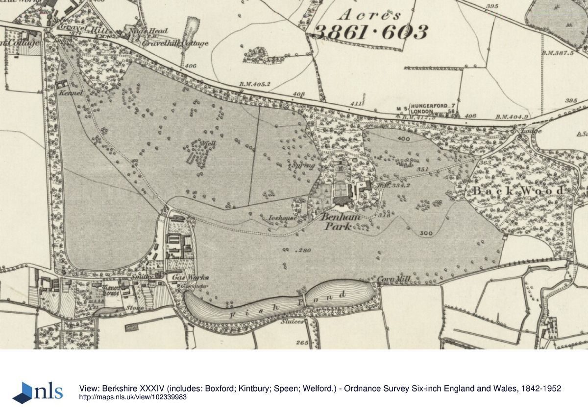
Benham Park lies 3km west of the centre of Newbury. The c 150ha site is bounded to the north by the A4 London to Bath road, marked by a brick wall, to the west by the lane south from the A4 to Marsh Benham, and on the other sides by agricultural land and woodland. The northern half of the park slopes down from the north boundary, with the house sited part way down the slope, overlooking the valley of the River Kennet to the south at the bottom of the slope. Beyond Brown's diversion and enlargement of the river into the lake, the land is level. Formerly water meadows, this area is crossed by several waterways and the main course of the river itself. The setting is rural, with the small village of Marsh Benham close by to the west, and to the south of this the extensive area of Hamstead Park (qv), with the A34 Newbury by-pass in the course of construction (1998) lying close to the east boundary.
Entrances and Approaches
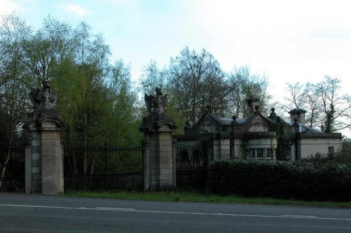
The main approach, from Newbury, enters the park 500m north-east of the house, forming a fork off the A4, the drive passing between two stone gate piers (late C18, listed grade II), each consisting of an arched opening flanked by rusticated columns which support a pediment. The piers support iron carriage gates, with further pedestrian gates set in the arched openings, and are flanked by stone screen walls, that to the west masking a small, single-storey, stone gate lodge (late C19, listed grade II), and that to the east masking a larger lodge (late C19, listed grade II) in similar style. The drive curves south-west down the hillside through woodland, opening out into pasture c 200m east of the house to reveal views south across the parkland and lake to the distant hillsides and countryside beyond. The drive curves south-west and north around a shrubbery to arrive at a turning circle enclosing a grass panel in front of the south, entrance front of the house. To the south of this a gently sloping lawn runs 50m down to a ha-ha separating the south side of the pleasure grounds from the park.
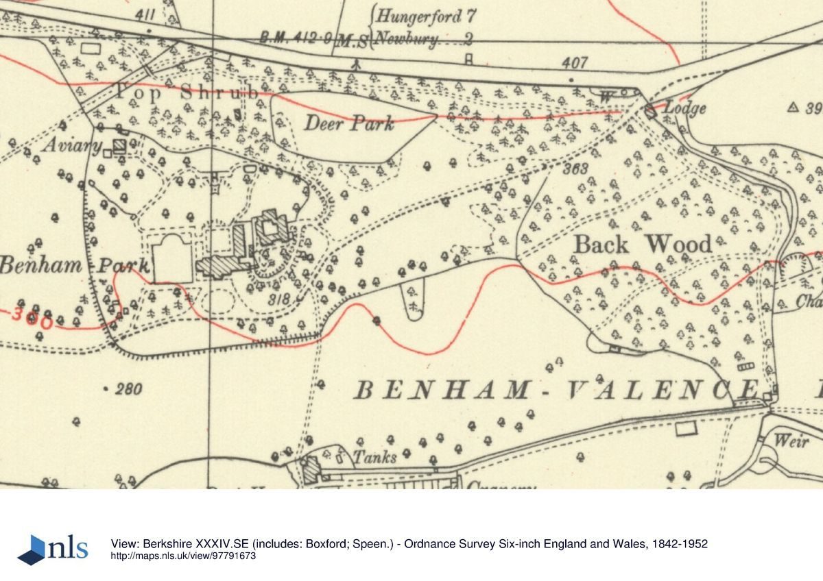
A former carriage drive entered the park 1km north-west of the house, off the A4, passing between elaborate stone gate piers (probably W Winde or Wynne, c 1662-78, listed grade I) brought from the Cravens nearby property at Hamstead Marshall in the C19. The piers support late C19 wrought-iron gates, with, adjacent to the west, the stone-built West Lodge (late C19, listed grade II). The drive, traces of which still exist as a farm track, ran south-east, crossing the park and passing the north end of the walled gardens before turning east and then north-east towards the house, entering the pleasure grounds between stone piers standing 150m south-west of the house before arriving at the turning circle by the south front.
A further former drive, now providing access to houses to the west and east of the lake, enters the park 800m south-west of the house, off the Marsh Benham lane at its south end, between two brick piers supporting iron gates, with a brick lodge set back to the east of the entrance on the north side of the drive. The drive runs east, turning north to skirt the walled gardens, joining the former west drive 500m west of the house, at the north end of the walled gardens. A spur off this drive, 200m east of the entrance to the park, continues east, past the south end of the walled gardens and between two large gate piers, running along the southern edge of the lake, past the boathouse and former mill house at the east end, continuing east to Back Lodge (late C19) standing at the east end of the park.
The former south drive, which provided access from Enborne, entered the south park 1.1km south of the house, adjacent to the railway. Now a farm track, the drive, which is raised above the level of the south park, runs past the site of the former South Lodge (gone, 1998), then runs north flanked by the remains of a mature lime and horse chestnut avenue, crossing the river via a small, ornamental, iron bridge. The south drive joins the west/east drive along the south side of the lake at a point where formerly it was carried north across the lake by a late C18/early C19 bridge (still present 1878, OS) which has largely disappeared apart from some of the revetments. The three-arched bridge, in Chinese style with a balustraded parapet, is shown in several late C18/early C19 engravings, lying at the south end of a former drive (gone, 1998) which ran north through the park, probably joining the former west drive some distance from the house.
Principal Building
Benham Park house (Henry Holland, assisted by Lancelot Brown, 1772-5, listed grade II*) stands towards the centre of the north park, sited at the bottom of a steep slope down from the north boundary, above an apron of informal lawn separated by the ha-ha from the parkland to the south, which slopes gently south to Brown's lake. The two-storey, rectangular house (which had an extra storey added in the late C19) is entered on the south front via a central tetrastyle portico, with a door at the centre of the north front giving access to the formal garden terraces climbing the steep hillside to the rear.
A former C19 wing (late 1870s, demolished late C20), attached to the east side of the main block, extended north covering an area now re-landscaped into a grass bank, at the top of which stand late C20 office buildings. The former stables lay to the east of this wing, this area also now (1998) covered by office accommodation.
Gardens and Pleasure Grounds
The gardens and pleasure grounds lie to the west, south and north of the house. The formal gardens, including elements possibly designed by W A Nesfield in the 1870s (Brown 1983), extend north from the house, and are enclosed within the largely wooded pleasure grounds. These extend north from the formal gardens as ornamental woodland towards the north boundary, branching to west and east along the woodland belt which skirts this boundary, and contain the remains of a former path system. A public footpath which briefly runs south-west to north-east for a short distance through the centre of the pleasure grounds is channelled beneath a brick and iron pedestrian bridge connecting the north belt with the south block leading down the gardens.
The formal gardens are entered from the north front, which opens onto a stone perimeter path surrounding a sunken lawn, formerly containing a cruciform pattern of paths (OS 1878) and currently (1998) laid to lawn with formal, clipped box hedging. Four sets of stone steps, one at the centre of each side and aligned on the former path system, give access down to the sunken parterre. The perimeter path leads 40m north from the house to a massive, stone, double staircase ascending the hillside to the north, supported by stone retaining walls topped by balustrading, with a terrace running along the top of the walls, overlooking the sunken garden below. From here a central flight of stone steps continues up the hillside to a former pond and fountain on a level plateau. Formerly a temple stood above this to the north, backed by the woodland.
The remains survive of an amphitheatre cut into the hillside below the temple, said to have been an outdoor theatre for Lady Craven in the late C18. Remains also still exist of a fence which formed the C18 north boundary of the garden area, and the topiary archway flanking the former temple. From here long views extend south over the house, lake and park to the distant countryside beyond. The site of the temple may have been chosen by Brown, and the building itself seems to have survived until the early C20 when the gardens began to be neglected. North of the site of the temple, 100m north of the house, steps lead up to a gateway set into a fence, set on an axis with the formal garden and house below, forming a boundary between the garden and pleasure grounds (Brown 1983).
From the west front of the house, a path leads west into a yew-hedged rectangular car park, formerly part of a formal garden feature (OS 1878) which survived into the C20. From here an informal path leads up the hillside into the western pleasure grounds, passing on its way the remains of a former aviary, situated 150m north-west of the house (only the foundations and floors now remain), together with a small summerhouse. Remains of a water garden planted around a stream survive on the hillside to the south of this (Brown 1983). This area was taken into the garden from parkland in the late C19.
Park
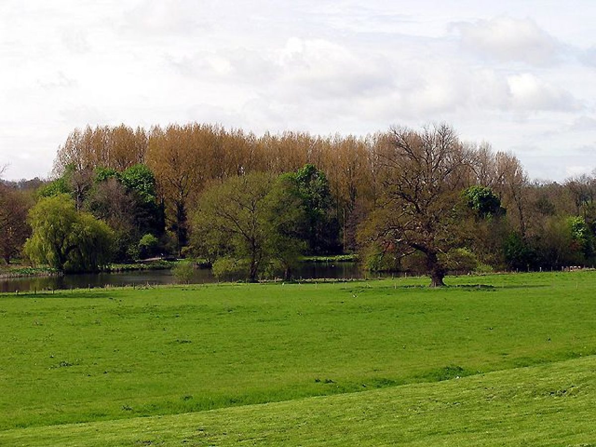
The park, in existence by the mid C18 (Rocque, 1761; estate map, 1775), and extended and developed by Lancelot Brown (1716-83) in the 1770s, encloses the pleasure grounds to the west, south and east, and is dominated by, and divided into north and south halves by Brown's lake, created by partially diverting the river. The lake, with its island lying towards the west end, is prominent in views south from the house and north park, formerly having been ornamented by the bridge giving access from the south drive. The view into the south park is however partially obscured (1998) by a line of mature poplar trees planted close to the south bank. The northern half of the park, believed (Stroud 1975) to have been laid out by Brown, is largely laid to pasture, with clumps and single mature trees including oaks and sweet chestnuts. The remains of a mature lime avenue runs east from the former mill house standing at the east end of the lake, close to the small, rustic wooden boathouse.
The largely level southern half of the park seems to have been laid out in the C19, and is principally laid to pasture with clumps and single trees and small woodland blocks, traversed by several drains and the main course of the river itself. Several of the drains are crossed by ornamental iron bridges, in similar style to that carrying the south drive across the river within the south park.
Kitchen Garden
The walled kitchen gardens lie 500m south-west of the house, enclosed and divided into several sections by 3m high brick walls. The associated service buildings and bothies have been converted into domestic accommodation, and two new houses built (late C20) within the walls, with the consequent use of the ground for associated ornamental gardens. One house has incorporated the restored glasshouse range standing at the north end of the northernmost compartment; the other house stands in the 0.5 ha southern walled compartment, and the associated spaces are used for domestic gardens.
Maps
- An Accurate Survey of Speen Mannour ... Belonging to ... the Duke of Chandos, (1730s-40s), (Newbury Museum)
- J Rocque, Map of Berkshire, 1761
- Map of Benham Manor, 1775 (Berkshire Record Office)
- OS 6" to 1 mile:
- 1st edition published 1877-8
- 2nd edition published 1913
- 3rd edition published 1938
- OS 25" to 1 mile:
- 2nd edition published 1911
Description written: May 1998
Register Inspector: SR
Edited: March 2000, November 2022
- Visitor Access, Directions & Contacts
Directions
Near Stockcross, west of Newbury, west of the A34 and south of the A4.
- History
The following is from the Register of Parks and Gardens of Special Historic Interest. For the most up-to-date Register entry, please visit The National Heritage List for England (NHLE):
17th Century
The manor of Benham Valence was obtained c 1630 by the trustees of Sir William Craven (1608-97), in whose family it remained until the mid C20.
18th Century
The sixth Lord Craven built Benham Place in the 1770s, employing Henry Holland as his architect, newly entered into partnership in 1772 with Lancelot Brown who laid out the grounds. Between September 1771 and May 1774 Brown was paid £7150, although this may have included payment for minor works in the house (Stroud 1975).
19th Century
In the late C19 a formal, terraced layout was created within the gardens, possibly by William Andrews Nesfield (Brown 1983).
20th Century
The house, having stood empty since 1946 following its requisition for military use during the Second World War, was sold in 1982, becoming the headquarters of an international company. The company partly renovated the grounds, building several new office blocks close to the house and demolishing the stable block. The grounds are in divided ownership.
Period
- 18th Century (1701 to 1800)
- Late 18th Century (1767 to 1800)
- Associated People
- Features & Designations
Designations
The National Heritage List for England: Register of Parks and Gardens
- Reference: GD1072
- Grade: II
Features
- Lawn
- Lake
- Description: Brown's lake
- House (featured building)
- Earliest Date:
- Latest Date:
- Ha-ha
- Gate Lodge
- Description: Stone gate lodge
- Kitchen Garden
- Description: Walled kitchen gardens
- Bothy
- Description: Multiple bothies have been converted into domestic accommodation
- Glasshouse
- Description: Restored
- Parterre
- Description: Sunken parterre
- Pond
- Description: No longer in existence
- Fountain
- Description: No longer in existence
- Temple
- Description: Ruins remained until early 20th Century
- Amphitheatre
- Description: Remains survive cut into the hillside near the temple
- Aviary
- Description: Former aviary - no longer exists.
- Water Garden
- Description: Remains of a water garden exist.
- Boat House
- Description: Remains of a rustic wooden boat house remain.
- River, Riverside Walk
- Ornamental Bridge, Bridge
- Description: three-arched bridge and an iron bridge.
- Key Information
Type
Park
Purpose
Ornamental
Principal Building
Commercial
Period
18th Century (1701 to 1800)
Survival
Extant
Hectares
150
Open to the public
Yes
Civil Parish
Speen
- References
References
- {English Heritage Register of Parks and Gardens of Special Historic Interest} (Swindon: English Heritage 2008) [on CD-ROM] Historic England Register of Parks and Gardens of Special Historic Interest
- Pevsner, N., (1966), p 225 The Buildings of England: Berkshire
- Hinde, T., (1986), pp 181-2 Capability Brown (Country Life article)
- Stroud, D., (1975), pp 169-71 Capability Brown (Country Life article)
- Brown, M., (1983), [unpublished report, copy held in EH file] Benham Park Landscape Report
- (1924), pp 103-6 Victoria History of the County of Berkshire 4