Introduction
The house, former deer park and current Country Park are set within the wider Haddo Estate. Features include walks, lakes and a terraced garden.
http://portal.historic-scotland.gov.uk/hes/web/f?p=PORTAL:DESIGNATIONS:0
Type of Site
A well-preserved country estate with an impressive, large-scale park and woodland structure centred on an 18th-century William Adam house. Distinctive design features include the terrace garden, currently undergoing restoration (2010), the long SE avenue, and the wide range of estate buildings and ornaments in the grounds. Most of the grounds are open to the public.
Location and Setting
Set in the agricultural heartlands of north-east Aberdeenshire, Haddo is one of the largest Inventory sites in the region. It is located nearly 20 miles north of Aberdeen, and five miles (8 km) west of Ellon in a landscape characterised by gently rolling landform, long open views and the shallow valley of the River Ythan, which flows just north of the designed landscape boundary. Haddo House itself occupies a central position within the designed landscape, and views from here tend to be contained within the surrounding extensive park and woodland policies. The axial, tree-lined avenues that extend from the house channel sightlines further, with the most impressive vista stretching south-east towards a large, terminating urn monument. From elsewhere in the policies, however, especially from higher ground, views extend further afield across the wider Banff and Buchan plain, and to the south towards the distinctive landmark monument of the Hill of Ythsie. Other distinctive features of the designed landscape include two sizable lakes formed in the 19th century and plentiful woodland and forestry cover, distributed as thick, curving belts, clumps and larger plantations. The thick swathes of trees are prominent in the local landscape and serve to enhance the scenic character of the area. Encompassing a total of 1282ha. (3168ac.), the designed landscape is defined in part by boundary walls and is bordered by minor roads.
Landscape Components
Architectural Features
Haddo House is a granite ashlar, Palladian mansion comprising a 3-storey main block with slightly advanced, pedimented west centre, and single-storey quadrants linking two-storey wings. Designed by William Adam c.1724-8, and executed 1731-6 by John Baxter, the original house was subject to major additions and alterations during the 19th century, including the addition of massive external granite steps (Archibald Simpson 1822), a kitchen court (J & W Smith 1843), a sizable chapel (G. E. Street, 1876-81) and in 1879-81, the construction of a ground floor entrance colonnade, together with further new windows, staircases, and internal planning by James Maitland Wardrop.
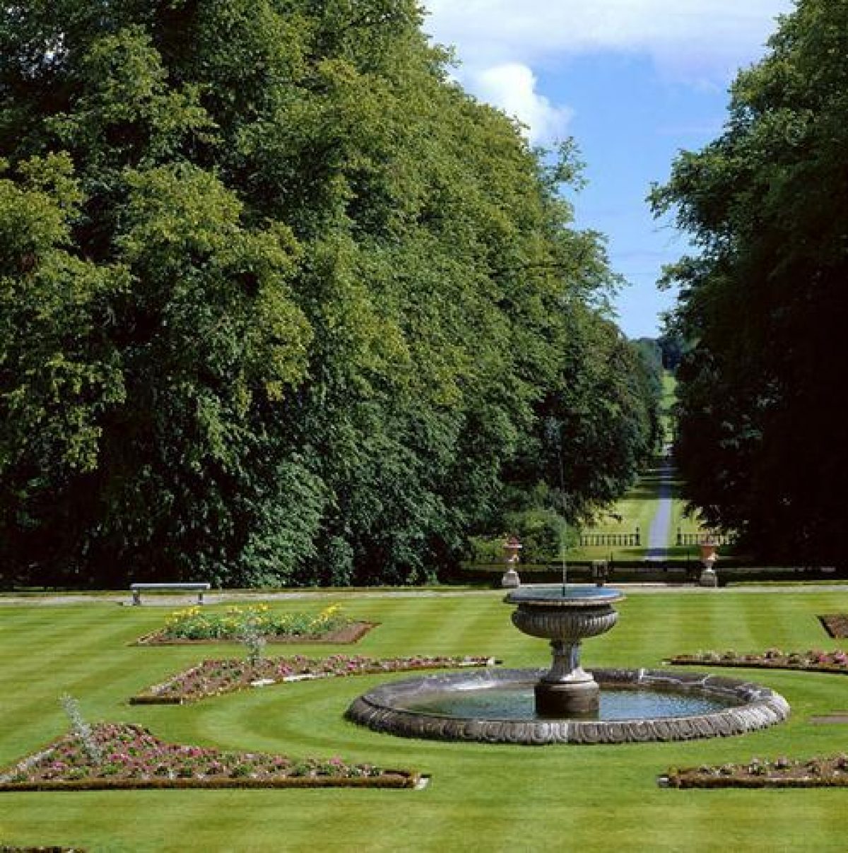
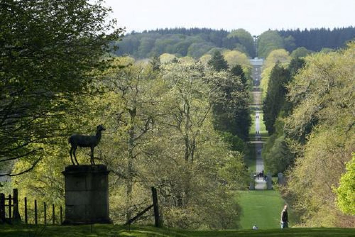
The formal gardens around the house are ornamented by a central, mid 19th-century fountain and a 17th or early 18th-century, cube-type sundial, located to the south-east. The smaller south lawn features a further, late 19th-century sundial distinguished by its open spherical copper dial and gnomon, and circular marble mount with lions in relief at the base. Below the garden terrace, the long, tree-lined south-east avenue is punctuated by mid 19th-century park furnishings, executed mostly by J and W Smith c.1844-7. They comprise flanking granite-pier balustrades, the 'golden gates' with their delicate cast-iron work and oversailing coat of arms, a pair of stags on tall granite plinths, and at the terminal of the avenue, an enormous monument designed as a memorial to the wife of the 4th Earl of Aberdeen. Completed in 1847, this comprises an inscribed, twenty foot-high granite urn on a pedestal, which serves to close the vista as seen from the house. The other major commemorative landmark at Haddo is the monument to Col. Sir Alexander Gordon; a distinctive, tall ashlar granite obelisk erected following the death of the 4th Earl's brother at Waterloo in 1815. Located 400m south of the house, it is mounted on a large plinth with long inscription and badge. In the woods some 500m ENE of Haddo House, meanwhile, is a gothic-style burial enclosure with granite archway, designed by Alfred Waterhouse in 1884.
Of the plentiful estate buildings in the designed landscape, those in the vicinity of Haddo house include the stable and coachhouse block, an elongated U-plan range attributed to A. Simpson in 1822 and possibly developed from two earlier cottages (Grant 2009: 12), and the adjacent, tall, single-storey Haddo House hall, constructed in 1891 by D. Macandrew and Company, and a fine example of a timber-built community hall. Located further to the south-west is an early 19th-century, granite-built ice-house. Elsewhere in the designed landscape, other 19th-century structures of interest include the Mains of Haddo farmhouse and office, the adjacent steading, with its segmental pend arch, the rectangular, rubble-built walled garden, the nearby Gardens Cottage and Butler's House, and the Laundry, located at the northern edge of the designed landscape, close to the Tudor style North Lodge. The long, single-storey, polychrome brick Pheasantry, built in 1884, is a particularly distinctive building, now used as a classroom facility by Aberdeenshire Council. The high, rubble wall, which encloses the deer park, is an early and striking component of the eastern part of the designed landscape. Other lodge buildings, meanwhile, include the South Lodge, or Raxton Lodge, c.1845 by J & W Smith, and the slightly later Keithfield Lodge with dwarf gatepiers and spear-headed railings (1878).
Drives and Approaches
The grand scale of the designed landscape demanded a good network of approaches, drives and service roads. Those present today were mainly established during the 19th century, and catered for both functional needs and aesthetic concerns. Useful sources of evidence for earlier routes are the two estate plans dated 1802 and 1806, which depict the straight, tree-lined avenue leading up to the house from the south-west (NAS RHP9926; NAS RHP9962), and an earlier improvement plan of 1776, depicting part of the route from Keithfield (NAS RHP9920). The main entrance in use today is via the mid 19th-century South Lodge, or Raxton Lodge, in the south-east corner of the designed landscape. From here the long drive sweeps first through woodland and then open parks before reaching the centre of the policies and Haddo House. The track leading from the mid 19th-century North Lodge represents a much more direct route, leading uphill from the Ythan valley, while from the south-west, a further entrance drive from Keithfield skirts the Keithfield Lake before curving towards the core grounds at Haddo.
Efforts to improve communication and access are perhaps most associated with the 4th Earl of Aberdeen. Writing in September 1826, he records 'discussing roads and plantations' for several hours, noting, 'In particular there is my new approach to the house, avoiding the avenue, which I scarcely know how to manage' (quoted in Grant 2009: 14). Work continued in the 1830s and 40s, with particular attention paid to devising attractive rides and circuits around the pleasure grounds. Of these, the most ambitious was almost certainly the long Green Drive, which snaked its way not only through the deer park, but also through most other areas of the policies. Traditionally attributed to the artist James Giles (LUC 1987), the drive was in place by 1849 (Grant 2009: 20), and is clearly labelled on the early Ordnance Survey editions (OS 1871-3; OS 1899-1901). Another achievement was the sweeping ride through Raxton Wood. A diary entry of 1844 records, 'The new road through Raxton wood is really a capital job, and affords some very good points of view' (Stanmore diary quoted in Grant 2009: 18).
Paths and Walks
During the 19th century, paths through the pleasure grounds were established for recreational pursuits. In 1844, a burn-side path was improved for otter-hunting, while in 1846, the new lakes, stables and kitchen garden were incorporated within a four mile circuit walked by the Aberdeen family every Sunday after church (Grant 2009: 18). Today, the tradition of leisurely strolls continues in Haddo Country Park. The ranger service offers occasional guided walks, and plans are in motion to supplement the existing network of historic footpaths around the grounds with further new and upgraded trails (Wall 2009).
Parkland
Described as a 'triumph of landscape gardening' in the 19th century (Morris 1879: 49), the attractive Haddo parklands retain their distinctive historic character. The oldest element is the deer park. Occupying rising ground to the east of the designed landscape, it pre-dates the present Haddo House, with the stone dyke probably built c.1690 (LUC 1987). Although Roy's 18th-century Military Survey depicts the enclosure as containing a swathe of open woodland and glades (Roy 1747-55), later accounts suggest a relatively treeless aspect by the start of the 19th century, perhaps as a result of a major storm in 1798 (Grant 2009: 8).
The present parkland landscape was developed in the first half of the 19th century by the 4th Earl of Aberdeen in conjunction with the artist James Giles. The scope of the project was ambitious, incorporating works to drain the boggy grounds of the 'Doolies' east of the house, straighten portions of the Kelly Burn (NAS RHP 9926), landscape the policies, create the two lakes, plant vast numbers of parkland and woodland trees, and stock the parks with deer. Although some woodland clumps were subsequently lost or amalgamated into plantations, the present designed landscape still retains its essential 19th-century structure, as so clearly depicted on the first and second Ordnance Survey editions (OS 1864-7; OS 1899-1901).
Today, the low-lying Doolies form a secluded park close to the house, enclosed by sinuous-edged woodlands, and dotted with specimen broadleaf and coniferous trees, including some veterans. The higher deer park to the east, and the surrounding, outlying parks are characterised by longer, open views, punctuated by carefully-placed parkland clumps and other landscape design features, including the avenue and the obelisk monument.
Avenues and Vistas
One of the most impressive landscape features at Haddo is the long S.E. avenue stretching over a distance of 1.3 km from below the formal garden terrace to the twenty foot-high urn monument on the opposite hillside. The origin of the design was the reorganisation of the landscape by William Adam c.1738, and the planting of a double avenue of limes leading from the raised parterre (much of which still exists). A century on, the limes provided the axis of the present avenue, established and adorned with gates and monuments in the 1840s as part of the 4th Earl's wider landscaping projects (Grant 2009: 6). By tradition, it is thought to represent a Scot's Mile in length. Today it remains not only a highly effective visual statement in the landscape, but also a tree-lined walk for visitors to the Country Park. A further, shorter avenue, known as the Victoria Avenue, leads north-east of the house. Likewise, it traces an older design feature dating from the earlier 18th century, and which is clearly depicted on Roy's Military Survey (1747-55).
Woodland
The country park and wider Haddo estate contain substantial tracts of mixed policy and commercially managed woodland. Occupying higher slopes and summits of the rolling hills, the plantations contribute texture, variety and interest to long landscape views in the surrounding area, and provide important habitats for wildlife. Like many other components of the Haddo designed landscape, the present structure of long sinuous plantations, belts and islands of trees derives mainly from the 4th Earl of Aberdeen's lifetime and his major programme of works in the 19th century. This work completely altered the previous landscape design, associated with William Adam and depicted by Roy in his Military Survey (1747-55). It also satisfied the contemporary view that tree-planting for pleasure and profit fulfilled the 'moral obligation' of a country gentleman (Grant 2009: 8). The 4th Earl invested large sums of money in the plantations, employed large teams, and took a close personal interest in the labour itself, writing in 1821, 'I am a good deal tired to-night'I staked out with Johnston two or three considerable plantations, and I took a couple of hours' hard work thinning the plantation at the bottom of the garden. I can tell you that if I live ten years more, I shall make this a really fine place' (quoted in Grant 2009: 12). By his own estimate, the 4th Earl planted somewhere in the region of 14 million trees (Chamberlain 2004). Although the species mix of the plantations is now different, the physical structure of the park and woodland landscape is virtually identical to that depicted in the earlier Ordnance Survey editions (OS 1864-7; OS 1899-1901).
Water Features
Kelly Lake and Upper Lake were formed in 1835-6 for the 4th Earl of Aberdeen. They were designed not only to augment the picturesque aesthetic of the pleasure grounds, but also to serve as outlets for various parkland drainage schemes (Grant 2009: 16). Today, the more central Upper Lake is the most prominent of the two and, since 1984, also connects with a smaller pond formed just south of the line of the S.E Avenue. Encircled by a path, the lake features two bird-hides, one of which occupies the site of the former boathouse. The lake and abundant waterside vegetation form a good habitat for birds, and visitors may observe both the resident ducks, and swans, together with seasonal visitors, such as overwintering geese.
A third lake, called Keithfield Lake is located near the south-west boundary of the designed landscape by the west drive. Although a scheme for a lake in this area had been drawn up as early as 1776, map-based evidence shows that it was not actually formed until the later 19th century (NAS RHP9920; NAS RHP9921; OS 1864-71; 1899-1901).
The Gardens
Occupying a level platform just below the south-east elevation of the house, the formal terrace garden is an exercise in symmetry and colour, and the subject of a phased programme of restoration by the National Trust for Scotland, set to continue until 2015. The history of the garden and its former design are now well documented (Grant 2009, Murray 2008). Shortly after the completion of the house itself, it is thought that in 1738, William Adam advised upon the creation of the raised, level parterres. Given the topography of the site, their execution constituted an astonishing feat of earth-moving (Grant 2009: 5). Meanwhile, the subsequent ornamentation of the terrace took place a century later, during the years 1834-48, when a series of sketches and paintings by James Giles depict the evolution of the terrace from a simple lawn with central fountain, to a colourful, symmetrical garden of parterres, seats and flowers. The accuracy of Giles' artistic record is borne out by later cartographic, photographic and archaeological evidence, and it is to this era of design that the NTS are working towards at the time of writing (Grant, pers. comm. 2009). The restoration project aims to re-establish lost terrace beds and planting styles, re-align the perimeter fence, refurbish the herbaceous borders, and restore gardenesque-style beds to the north of the terrace.
Haddo is also known for its numerous specimen trees, many of which were planted during the 19th and earlier 20th century to commemorate the visit of distinguished guests. Standing tall in the grounds beyond the garden terrace, they include two Wellintonia planted by Queen Victoria and Prince Albert in 1857. Forty specimens were measured in 1980, and at the time of writing, (2011) another tree-survey is planned in order to better document the range and condition of the specimens.
Walled Garden
Located 500m due west of Haddo House, the large rectangular, rubble-built walled garden was constructed in the early 19th century. It incorporates fine mid-18th century wrought-iron gates and gatepiers, (probably by John Baxter), and thought to have been relocated from the former west avenue. Historical records show that by 1828, the garden contained glasshouses for flowers, vines and fruit (including melons, figs and pomegranates), and box-edged compartments for a wide range of vegetables, fruit, and flowers (Grant 2009: 14). Surviving photographs from the 1890s, meanwhile, reveal a typical, immaculate Victorian walled garden and a 14-strong team of gardeners. The first Ordnance Survey edition depicts the regular compartments divided by a long, central path extending along the long axis of the garden; an element that survives to the present day (OS 1864-7). The walled garden now contains a private residence on the north wall, while the rest is divided into large, symmetrical compartments of lawns and some cultivated beds.
- Visitor Access, Directions & Contacts
Telephone
01651 851440Access contact details
The gardens are open daily throughout the year. The house is open between April and October.
Directions
Haddo House is off the B999 near Tarves, at Raxton crossroads, 4 miles north of Pitmeddon. It is 1 mile from the National Cycle Network. The bus stops at Tarves, about 4 miles away.
Owners
The National Trust for Scotland
Aberdeenshire Council
- History
The following is from the Historic Environment Scotland Gardens and Designed Landscapes Inventory. For the most up-to-date Inventory entry, please visit the Historic Environment Scotland website:
http://portal.historic-scotland.gov.uk/hes/web/f?p=PORTAL:DESIGNATIONS:0
Reason for Inclusion
Haddo is an outstanding example of 18th and 19th-century landscape design, associated with William Adam, the artist James Giles, and George Hamilton-Gordon, 4th Earl of Aberdeen. Valued as a 'triumph of landscape gardening' in the Victorian era (Morris 1879: 49), the extensive policies continue to make a major contribution to the scenic quality of the local area.
Main Phases of Landscape Development
Earlier 18th century, 1804-50s
Site History
The present designed landscape of Haddo House dates to the 18th and 19th centuries and is most associated with the prominent figures William Adam (bap.1689-1748), George Hamilton-Gordon, the 4th Earl of Aberdeen, (1784-1860) and the artist James Giles (1801-1870). The documented history of the land, however, can be traced further back. Formerly known as Kelly, the estate was named in a 13th-century charter and described as a barony in the 15th century (Grant 2009: 3). The old house was placed under siege by the Earl of Argyll's Covenanting forces in 1644, and was finally dismantled in the earlier 18th century. Little is known about the building except that during works to erect the Haddo House hall in 1890, workmen discovered foundations, 'about 10 feet thick, which might have been the ancient House of Kelly' (Bremner 1892, RCAHMS NJ83SE 21).
The Gordon family first acquired landholdings at Kelly in the late 15th century, and continued to obtain neighbouring estates during the 16th and 17th centuries. The name Haddo appeared during this time and is thought to derive from the word 'davoch', meaning a unit of agricultural land* (Grant 2009: 3; Adams 1976: 5). Early efforts to embellish the core landscape of the estate took place in the later 17th century during the lifetime of Sir George Gordon, 1st Earl of Aberdeen. The deer park walls were built, and an avenue of ash trees planted, of which one still remained in 2005 (Grant 2009: 4).
The earlier 18th century proved to be the first period of major change. Inheriting the property as the 2nd Earl of Aberdeen in 1720, William Gordon invested heavily in the improvement of Haddo and the acquisition of further Aberdeenshire properties, including Fyvie Castle (q.v.Inventory). He commissioned designs for a new, classical house from architect William Adam in the 1720s, and it seems likely that Adam also advised on a new landscape scheme that incorporated raised and level parterres and a double lime avenue leading from the south-east elevation of the house (LUC 1987; Grant 2009: 6). Roy's Military Survey depicts other key features of a fairly ambitious landscape design, including another tree-lined avenue to the north, planting in the deer-park, and the Saltire Wood: A rectangular plantation on the site of the present Knockorthie Wood split with radial rides and converging on a central rond-point, or opening (Roy 1747-55).
In the later 18th century, the new grounds declined. The 3rd Earl (1722-1801) attained a rather infamous reputation, while a storm in c.1798 is thought to have caused extensive damage. By popular account, when the young 4th Earl of Aberdeen arrived at Haddo in 1804 following his Grand Tour, he was met with a 'cold and cheerless' scene, in which the short lime avenue 'terminated in a dreary and extensive peat moss, which lay stretched between it and the grim high walls of a distant deer park' (newspaper cutting quoted in Grant 2009: 8).
Clearly undaunted, George Hamilton-Gordon, the 4th Earl, effectively opened a new chapter for the estate. In addition to pursuing public office, and serving as Prime Minister from 1853-55, he is also known at Haddo as the 'Premier Earl'. In contrast to his grandfather, the 3rd Earl, he was a scholarly and energetic laird who took a strong, personal interest in the reorganisation, development and improvement of the policies. He counted landscape theoretician Uvedale Price among his friends, and is credited with establishing model leases for all the tenants (Chamberlain 2004). The Haddo estate by this period was vast, and the plans for the designed landscape were of a similarly grand scale. During the first half of the 19th century, woodland trees were planted on an epic scale, and with the help of labourers and gardeners, virtually all of the main components of the present designed landscape were staked out, built, planted, or excavated, including the parks, drives, paths, terrace garden, the long SE avenue, the walled garden and lakes. In 1822, Gordon reflected 'I think we may enjoy a residence here for sometime', and indeed he lived until 1860. In addition to the personal vision of the 4th Earl, current research also stresses the influence of the artist, James Giles, who was instrumental in advising on and recording certain aspects of the pleasure grounds, most notably the colourful terrace garden.
In the later Victorian era, various planting and building projects continued. Notably, and unusually, the pleasure grounds also became the setting for occasional parties and gatherings organised by the 7th Earl and his wife, Countess Ishbel, in their pursuit of a more inclusive and 'improving' environment for their tenants and employees ' an attitude that provoked suspicion and rumour within aristocratic circles (The Times 1991). It was in this spirit that Haddo House hall was built in 1890, devised as a community hall for leisure and learning, while the grounds were also opened up to visitors. During this period, however, the fortunes of Haddo declined. Thousands of acres of the estate were sold, and debts gradually mounted as the 20th century progressed. From 1939, the mansion was used as a wartime maternity hospital, and the long-term future of Haddo looked uncertain.
The later 20th century, however, signalled another new chapter for the house and landscape. Under the influence of June Gordon, Marchioness of Aberdeen and Temair (1913-2009), the local cultural role of Haddo was revived with the founding of the Haddo House Choral and Operatic Society in 1945, an organisation that remains strong today. Since 1978, the house, contents and immediate policies have been under the ownership and management of the National Trust for Scotland. The Country Park is owned and managed by Aberdeenshire Council, while the wider Haddo estate remains in the ownership of the Gordon family. Working in partnership, the three organisations place a strong emphasis on retaining the historic structure of the designed landscape, while improving the habitat and amenity value of the grounds. Most recently, the Heritage Lottery Fund announced a grant of nearly a million pounds to execute a phased regeneration project in the Country Park (www.hlf.org.uk 2009 ).
* During the 18th century, a davoch in the north east of Scotland equalled 4 ploughlands having 8 bovates in each. A bovate was as much land as one ox could plough in a year (Adams 1976: 5).
- Associated People
- Features & Designations
Designations
Historic Environment Scotland An Inventory of Gardens and Designed Landscapes in Scotland
Historic Environment Scotland Listed Building
- Reference: Keithfield Lodge, Gates and Gatepiers
- Grade: B
Historic Environment Scotland Listed Building
- Reference: Stables and coach house
- Grade: B
Features
- Lake
- Description: Two lakes created in the mid-19th century.
- Earliest Date:
- Latest Date:
- Ornamental Fountain
- Description: A mid-19th century fountain on the east parterre.
- Earliest Date:
- Latest Date:
- Avenue
- Description: An early-18th century lime avenue is the most distinctive feature of the formal landscape. It is a 'Scots mile' long (1.25 miles) and terminates in an urn and pedestal.
- Earliest Date:
- Latest Date:
- Sundial
- Description: A 17th- or early-18th-century cube-type sundial
- Balustrade
- Description: Mid-19th-century balustrades
- Earliest Date:
- Latest Date:
- Obelisk
- Description: A monument dedicated to Sir Alexander Gordon who died in 1815 at Waterloo.
- Earliest Date:
- Urn
- Description: An urn and pedestal situated at the end of the vista eastwards from the house.
- Earliest Date:
- Latest Date:
- Tower
- Description: The Monument Tower commemorating the Prime Minister, 4th Earl.
- Parterre
- Description: Formal parterres.
- Earliest Date:
- Latest Date:
- House (featured building)
- Earliest Date:
- Latest Date:
- Garden Terrace
- Herbaceous Border
- Key Information
Type
Estate
Purpose
Recreational/sport
Principal Building
Domestic / Residential
Survival
Extant
Hectares
1282
Open to the public
Yes
- References
References
-
Historic Scotland, 'Haddo House', {Gardens and Designed Landscapes},
Contributors
Historic Scotland
-
Historic Scotland, 'Haddo House', {Gardens and Designed Landscapes},