Introduction
The present park and policies are a good example of a late-18th-century design that was modified in the early-19th century and little changed since. The layout includes an artificial loch and a walled garden in three sections. There was some woodland planting in the late-19th and early-20th centuries.
http://portal.historic-scotland.gov.uk/hes/web/f?p=PORTAL:DESIGNATIONS:0
Type of Site
An intact designed landscape of parks, woods and a long artificial loch, developed in the later 18th century to provide new pleasure grounds for the much older Fyvie Castle. The core of the designed landscape is managed by the National Trust for Scotland and there is a strong amenity focus in the development of new garden areas and visitor events. The policies also contain an interesting range of 18th - early 20th-century buildings.
Location and Setting
The designed landscape is located just north of the village of Fyvie, and approximately 8 miles (13 km) to the south of Turriff. It is situated within the valley of the upper Ythan river, which meanders through the Banff and Buchan plain, bounded by broad and rolling hill ridges. Like much of the region, this is a well-settled, intensively farmed area and the substantial woodland policies of Fyvie make a major contribution to the scenic diversity of the area. Fyvie Castle itself is situated on a small bluff or plateau just above the Ythan. Before the drainage, planting and landscaping projects of the late 18th century, this was a defensible site fitting for the original medieval castle, encircled by the river to the north and north-west and tracts of boggy ground to the south and east. Today, views from the castle encompass undulating parkland, the long artificial loch of Fyvie and extensive mixed woodlands, which surround the parks and ascend the steeper valley slopes along the east and west edges of the designed landscape. Encompassing a total area of 287ha. (709ac.), the designed landscape is bordered to the west by the modern transport corridor of the A947. Elsewhere, the boundaries are formed by minor roads and the outer edge of the woodland policies.
Landscape Components
Architectural Features
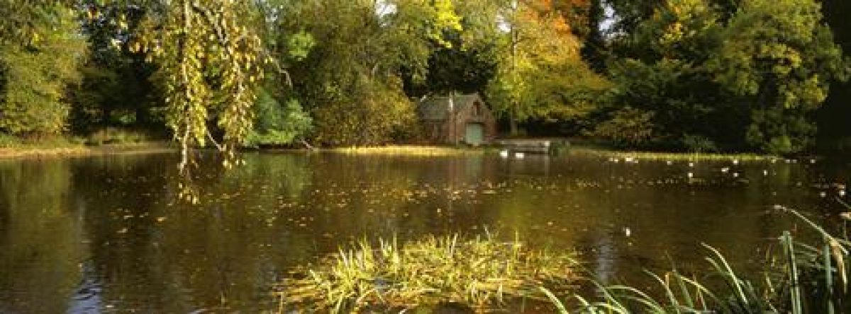
Fyvie is an outstanding, multi-period castle, notable for its five towers and 'fantasy façade' of corbelled turrets, parapet, carved dormer windows, finials, string-courses, and armorial panels (McKean 1990: 74). Its complex history began with the erection of a simple quadrangular structure in the mid-13th century (Slade 1985: 157). Ambitious late medieval-Renaissance projects of extension and alteration achieved much of the sheer mass of the structure visible today in the principal south range. These projects culminated in 1596-99 with remodelling works for Alexander Seton that included the execution of the central Seton tower, the raised roof-line of the flanking, earlier Meldrum and Preston towers, and the unique exterior adornment of the façade. The north and east ranges of the quadrangular castle were lost by the mid 18th century, leaving the present L-shaped plan. Subsequent major additions include the Gordon Tower on the west range (1777) and the Leith Tower, by John Bryce in 1890. The clock-tower by A. Marshall Mackenzie was added to the north side of the Seton Tower in 1899, and bears the coats-of-arms of the five families most associated with the Castle. Notable architectural features in the vicinity include the crenellated Raquets Court (1903), the small rubble, 18th-century privy with pyramid roof, and the single-arched Ivy Bridge over the River Ythan, erected shortly after 1816 with ashlar vouissoirs. On the north-east bank of the loch, the boathouse is a square gabled structure built c.1816-20 with red sandstone dressings, heavy square buttresses with pinnacles, and a semi-elliptical arch open to the water.
Two hundred metres to the east of the castle, the partially-ruinous Old Home Farm dates mainly to 1777, with 19th-century eastward extensions. The complex incorporates two courtyards, the larger with cobbled paths around the side and a central, rectangular dung-pit. The ranges include a threshing barn, diesel bay, byre, pig sty, wintering shed, stabling for ponies and traps, a doocot tower, clock-tower and bellcote (Murdoch 1995: 30). A row of terraced cottages stands to the north along with a two-storey, harled, late 18th-century laundry. The large walled garden complex sits immediately to the south of the Old Home Farm. Also constructed in 1777, it comprises three rubble-walled compartments, with the largest, southern-most compartment bounded by a curved low south wall.
The western edge of the designed landscape is defined by a sandstone rubble boundary wall. The north lodge (1816), with angle towers and crenellated screen wall, comprises an upper lodge flat above a tall arched pend. At the east gate (c.1816) the screen wall across the drive also boasts crenellations, while the adjoining lodge is a more simple single-storey cottage. Further along the east drive towards Fyvie is Oldwood Cottage, a heavily crenellated, Tudor-style house of c.1824 believed to have been commissioned by General William Gordon for his wife, Belle Black, later Lady Gordon. On the road leading north from Fyvie, the entrance to the core policies is distinguished by John Bryce's south gates, (c.1890), comprising rusticated red ashlar piers, with flank walls, and intricate wrought iron gates.
Drives and Approaches
There are three principal drives to the castle, all established by the early 19th century (Innes 1822). Leading from Fyvie village, the south drive forms the most important approach and the main visitor access today. It enters the policies via John Bryce's late 19th-century gates before skirting the west bank of the loch under a canopy of mature deciduous trees. In spring, masses of daffodils bloom here. After passing a small grove of young white stem birches (planted 2008), the drive curves towards the castle forecourt, affording an impressive first glimpse of Fyvie Castle. The shorter north drive enters the policies underneath the tall, arched pend of the north lodge and curves through woodland before leading over Ivy bridge and over the Ythan, immediately to the north-west of the castle. The east drive, meanwhile, appears to be an older route as it closely matches the trajectory of a road depicted on the estate plan of 1768. It passes to the south of the walled garden, and links up with other paths and service tracks before joining the main south drive.
Historically, the main approach to the late medieval castle was almost certainly from the south, via 'le Stanyford', as mentioned in 1325 (Simpson 1938: 36). This probably correlates with the old fording point and track at Bridgend, to the south-east of Lewes at the Howe of Fyvie (ibid.).
Paths and Walks
One of the most popular walking routes in the policies today is the circuit around the loch of Fyvie, a path established by the time of the first Ordnance Survey edition (1864-71 OS 6'). Another path in the east of the designed landscape passes close to Montrose's Camp, the scheduled earthworks associated with the Marquis of Montrose's 17th-century stand against the Covenanter forces. Meanwhile a sandstone archway bearing a date-panel of 1906 next to the west lodge on the A497 bears witness to a former pedestrian route into the policies that led from the old railway station at Fyvie to join the north drive at Ivy Bridge.
Parkland
Castle Dale forms the principal area of parkland within the designed landscape. Located between Fyvie Castle and the loch, it was developed and planted as part of the late 18th century improvement work instigated by General William Gordon, and remains an important scenic component of the designed landscape. Fine specimens of oak, sycamore, lime and copper beech stand individually or in loose clumps on the undulating ground. Used as a private golf course prior to World War II (LUC 1987), Castle Dale is now grazed. The other parks at Fyvie are also mainly used for grazing and are mostly without trees. The estate plan of 1822 suggests the area to the north of Fyvie Castle was once also liberally planted with individual specimens and a large roundel (Innes 1822). In recent years, some new individual saplings have been planted in the open areas by Home Farm, in the north east of the designed landscape (Information courtesy of owners 2009).
Woodland
Victorian commentators noted the 'fine extent', and 'beautiful and thriving' woods at Fyvie (Ross 1884: 49; New Stat. Acc.: 330), and today, the mixed policy woodlands remain an excellent resource in terms of both scenic and nature conservation value. In addition to covering the steeper valley sides, the woods encircle the parks, loch, and the complex of garden and steading buildings at Old Home Farm. They contain differently-aged timber, ranging from a few hardwood survivors of the late 18th century (oak, beech and ash), to younger stands of spruces, firs and some pines, many of which were established to replace 400 acres of woodland destroyed by the gale of January 1953.
In terms of dating, the evidence suggests that while there was some tree-cover at Fyvie during the 1760s, (the long tract to the east of the designed landscape, and some smaller plots along the Ythan) (NAS RHP711; NAS RHP11), the main period of woodland planting took place during the last decades of the 18th century alongside General Gordon's other improvement projects. Ross cites the specific date of 1785 for planting work, and the Statistical Account of 1793 mentions plantations of oak, ash, plane, beech, larch, pine and common firs (Ross 1884: 49; Stat. Acc.: 460). Certainly the estate plan drafted in 1822 indicates that the present-day structure of woodland and parks had been achieved by this time (Innes 1822). Immediately to the south-east of the designed landscape, the forestry plantation of Den Wood was also originally planted during this period as policy woodlands (Ross 1884: 48-9).
Woodland Garden
Numerous exotic trees and shrubs were planted at Fyvie from the mid-later 19th century and again during Alexander Forbes-Leith's time at the turn of the 20th century (Photo JV-1689; LUC 1987). Today, mature specimen trees can be found dotted along the drive and around the loch and walled garden (LUC 1987). Most prominent, however, are those in the immediate vicinity of the castle, standing both as dispersed individual specimens among the deciduous trees, and within a denser group to the east of castle. The trees include several fine specimens of Noble fir and cypress varieties (LUC 1987), and two Columbian silver firs, planted to commemorate the royal visits of Prince Arthur of Connaught (1902), and Alfonso XIII of Spain (1906). A couple of Korean firs to the south-east of the castle are two more recent additions. The tradition of planting exotic trees also continues elsewhere in the Fyvie estate, with two Wollemi pines planted in 2004 close to Home Farm, to the north of the designed landscape.
Water Features
The artificial Loch of Fyvie is a crucial element of the late 18th-century design. The main drive curves around its west bank and clumps of trees frame views across the water. A path around the loch is mapped on the first edition Ordnance Survey (1864-71 OS 6'), and the circuit remains popular with walkers today. From the path and drive, there are frequent glimpses of the boathouse, and the densely wooded banks form an attractive back-drop to the views. A bird-hide on the west bank affords the chance to observe a wide range of bird-life.
The loch was created when General Gordon instigated a range of improvements to the policies during the late 18th century. Pools and tracts of marshy ground were drained, and the Ythan and its tributaries partially canalised in order to reclaim land and achieve the desired and fashionable pleasure grounds of lake, parkland and woods. External influences on the loch design may possibly have come from landscape designers Robert Robinson (1734-after 1782) and later, James Giles, (1801-70), who was a personal friend of General Gordon's son, William Gordon (LUC 1987; Hartley 1996: 29). In the National Monuments Record of Scotland, a copy of a plan and section for an ornamental weir on the River Ythan at Fyvie, drafted in 1901, reveals continued interest in the manipulation and adornment of the natural water sources of the landscape at the start of the 20th century (RCAHMS NMRS).
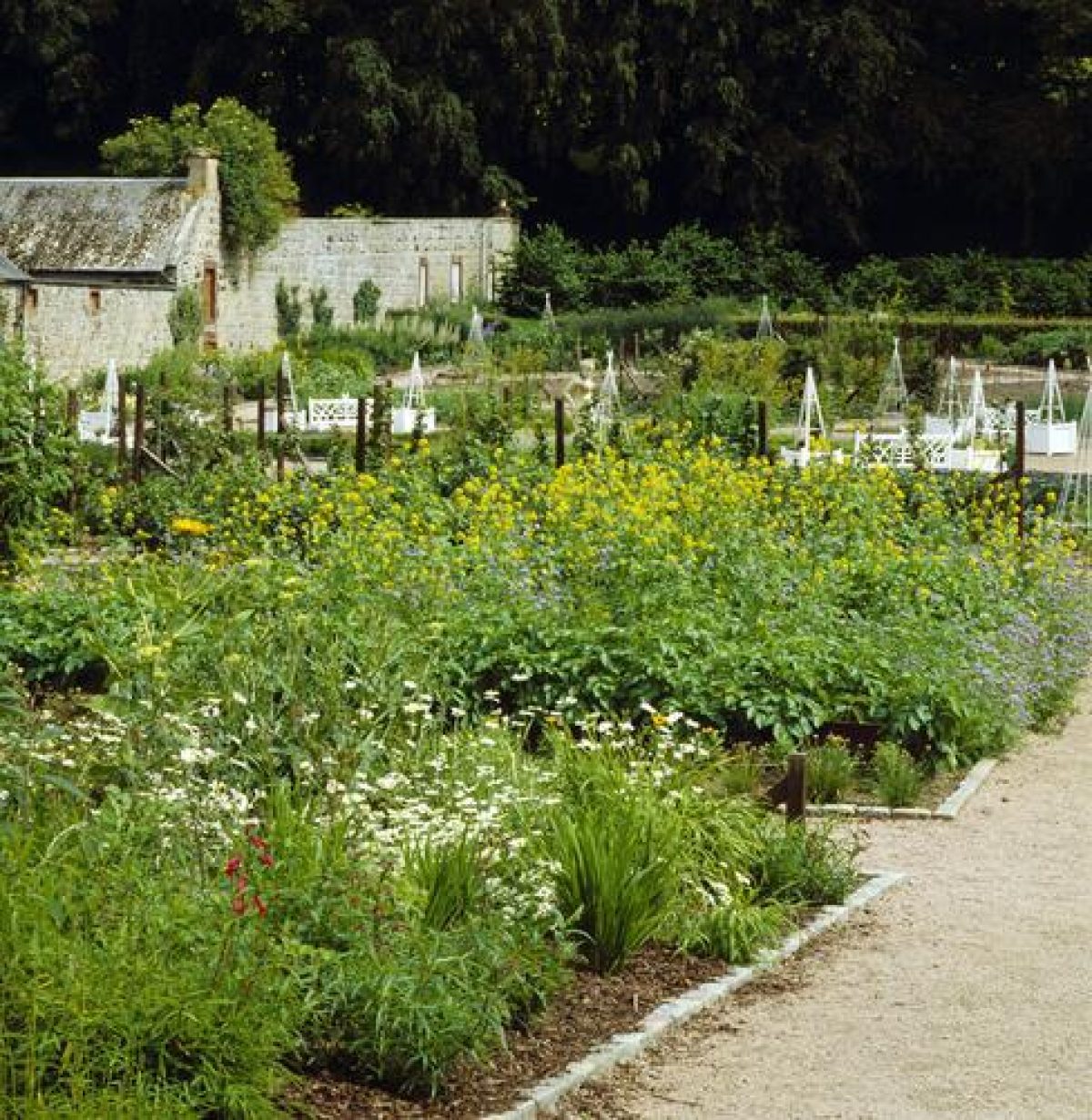
Walled Garden
The walled garden is now one of the highlights of Fyvie, with a new, redesigned garden of Scottish fruits and vegetables located in the northern third of the enclosure, and a restored ornamental shrubbery tended in the southern section. Dating as a whole from c.1777, the walled garden was constructed at the same time as the adjacent Home Farm complex, and replaced an earlier, square, enclosed garden located immediately to the south-west of Fyvie castle, (NAS RHP711; NAS RHP11; Innes 1822). Covering a total area of 3 ha. (275 ac.), the present walled garden retains its original structure of three distinct compartments, (Innes 1822, 1864-71 OS). In the 19th century, each section possessed a different character. The Ball Green in the northern third contained what was reputed to be the oldest fig house in Scotland (LUC 1987). The central section, known as Rhymers How or Haugh, was for the cultivation of fruit, including mulberries, peaches, nectarines and grapes (LUC 1987), while the southern third, with its outwardly curving low south wall, contained exotic trees, shrubs, paths and seating, and was clearly intended more for leisure than horticultural production. In the latter half of the 19th century, the gardens were developed further with the addition of frames and Dutch-lights in the northern section (Grant 2009: 2), and the conversion of the principal glasshouse range into an impressive suite of conservatory and hothouse structures (Hartley 1996: 29). Admired by visitors from the Banffshire Field Club in 1903, the cultivated garden provided work for a team of eight in the earlier 20th century, and remained in use until the outbreak of World War II (Banffshire Field Club Trans. 1903: 58; LUC 1987).
When the National Trust for Scotland acquired the property in 1984, the glasshouses were derelict and much of the garden space was laid to grass. The central portion of the garden was converted for use as car-parking, while the other compartments became the focus of a programme of restoration, launched by the National Trust in 1995. In the northern section, the garden of Scottish fruits and vegetables was designed by Robert Grant, with the geometric layout inspired by motifs found on the plaster ceilings of certain rooms in the castle (Grant 2009: 3). Highly commended in two categories in the Aberdeenshire Design Awards 2006, the garden is a well-stocked, colourful and productive area that boasts new statuary and gates, and a very impressive range of carefully documented fruit stocks, including many rare and historic cultivars. Although the important Scottish apple collection was largely destroyed in 2006-07 when a 'squad of bunnies' invaded (Grant 2009: 5), work is ongoing to rebuild the diverse range of fruits. In the meantime, the name Rhymers Haugh has been reassigned to the southern-most section of the garden, where the character of the original shrubbery persists. In this more leafy compartment, older elements of the garden, including tall conifer specimens and shrubs, and the old garden gates and gatepiers, have been complemented by younger saplings and ornamental plants.
Immediately to the west of the walled garden is a triangular area of lawns, paths, shrubs and trees, known as the American Garden. Formerly maintained as a rose garden, this garden space was developed following the arrival of the National Trust for Scotland in order to commemorate the historic link between the Forbes-Leith family and the United States of America.
- Visitor Access, Directions & Contacts
Telephone
01651 891266Access contact details
The gardens and grounds are open daily all year.
Directions
http://www.nts.org.uk/Property/Fyvie-Castle/Getting-there/
Owners
The National Trust for Scotland
- History
The following is from the Historic Environment Scotland Gardens and Designed Landscapes Inventory. For the most up-to-date Inventory entry, please visit the Historic Environment Scotland website:
http://portal.historic-scotland.gov.uk/hes/web/f?p=PORTAL:DESIGNATIONS:0
Reason for Inclusion
An exceptional designed landscape that scores highly in all categories. Fyvie is also becoming increasingly well-known for its new garden of Scottish fruits, which contains an outstanding collection of rare and historic cultivars.
Main Phases of Landscape Development
Late 18th-early 19th century, late 19th century, 1995-2006
Site History
Fyvie Castle was a royal stronghold of the 13th to later 14th centuries, erected on a plateau defended by the River Ythan and tracts of wet, marshy ground. As a defensible site, administrative centre, and probable hunting lodge, it served the needs of a largely peripatetic medieval Scottish monarchy. Documentary evidence places William I (the Lion) there in either 1211 or 1214 and Alexander II in 1222. Edward I of England also spent a night at 'Fyvim Chastel' during his rapid northern incursion of the summer of 1296 (Tyson 2001: 140).
The estate was assigned out of Crown ownership during the late 14th century, and Fyvie Castle subsequently passed through the Preston and Meldrum families before its acquisition in 1596 by Alexander Seton, Earl of Dunfermline (1555-1622). Seton was a prominent political figure of the day, and his influence and wealth is manifest not only in his remodelling and lavish embellishment of Fyvie Castle, but also his later projects at Pinkie House, East Lothian (q.v. Inventory).
While modern architectural and historical investigations chart the complex history of the castle itself during this period (Simpson 1938; Slade 1985), there is much less readily available information on the nature of the associated late medieval or Renaissance garden grounds. Park Burn to the east of the loch may derive from the name 'King's Park', applied to the land adjoining the castle in 1395 (Simpson 1938: 38). In 1578, even before Seton's work, Fyvie was described as a 'noble palace' (Glendinning et al. 1996: 43), and Charles I spent part of his childhood at Fyvie in the early 17th century. It is likely that by this period ,some form of enclosed garden would have adorned the elevated grounds around the castle, and recent archaeological research by the NTS has revealed some evidence of past garden areas on the main castle lawn (Grant pers. comm. 2011)
Fyvie, however, became the arena for conflict and uncertainty during the mid to late 17th century, most notably in October 1644 when the depleted forces of James Graham, Marquis of Montrose held their ground against the Earl of Argyll's Covenanters by digging a network of defensive ditches. The remains of their entrenched camp are located on the high ground to the east of the castle. Fifty years later, and a century after Alexander Seton first bought Fyvie, his grandson, the 4th Earl of Dunfermline, died penniless in Paris in 1694, an exile of the Jacobite cause. The estate was forfeit in 1690, and reverted to Crown ownership once again.
Like many large estates across Scotland, the 18th century proved to be a period of significant change. The Gordon family purchased Fyvie in 1733, and were subsequently at the helm of a series of landscaping projects that transformed the grounds around the castle. The cartographic record forms a useful source of evidence. Near the beginning of this era, Roy's Military Survey depicts the castle, labelled 'Fyvie House' as surrounded by three, simple 'tree-girt' fields (1747-55; Hartley 1996: 28). A more detailed estate plan of 1768 shows a square, enclosed garden immediately to the south-west of the castle, divided into four quadrants. Also depicted are the older routes through the estate, the areas of marshy ground, and a cluster of farm buildings located to the south of the castle (NAS RHP711; NAS RHP11). Half a century on, and another estate plan, completed in 1822, attests to a substantially different landscape, and one that remains recognisable as the designed landscape of today (Innes 1822).
Work to drain the peat-bogs, create the lake, plant the parks and woodlands, remove older structures, establish new entrance-ways, and build the new Home Farm complex and walled garden commenced at the instigation of General, the Hon. William Gordon of Fyvie (1736-1816) in the decades following his Grand Tour to Italy in 1766. Although Gordon's son, also William, later claimed the credit (Hartley 1996: 29), the improvements were mostly accomplished during his father's lifetime, with perhaps just some further planting and drainage projects continued by William junior (New Stat. Acc. 319; 331). With such radical changes in place, Fyvie began to attract praise during the mid to later 19th century, including this from Billings, ''the grounds, so park-like and carefully laid out ' the meadows and broad trees, and the swans sailing in wide, lake-like ponds, reminds one of English park scenery' (2008 [1845-52] v.1: 379).
Towards the later 19th century, the fortunes of the Gordon family began to dwindle. Judging from a surviving letter to his mother, the visiting artist, James Cadenhead was mildly scandalised by the household; 'The life here is vastly entertaining, but decidedly fast' he wrote in 1884 (NAS RH4/204). A year later and Fyvie was put on the market, to be purchased four years on in 1889 by the wealthy steel magnate, Alexander Forbes-Leith (1847-1925). Born locally, but with a fortune made in Illinois in the United States, Forbes-Leith invested a considerable sum in Fyvie. He transformed it into a lavish home and venue for visiting parties of distinguished guests that included in 1906, King Alfonso XIII of Spain (Coburn 2009). Money was spent on arts and antiques, and a range of renovation, building and landscape projects, such as the new Gordon tower on the castle, new south gates, and the Racquet's Court. The turn of the 20th century, however, proved to be the final era of abundance.
During both World Wars, Fyvie had been used as hospital accommodation, and in 1966, while retaining ownership of the wider estate, the Forbes-Leith family moved out. Fyvie Castle, its contents, and the core policies were sold to the National Trust for Scotland in 1984 and the property now receives somewhere in the region of 35-45,000 visitors per year (information courtesy of NTS 2009). The emphasis for management is placed firmly on retaining the historic structure of the grounds, while also developing their amenity value.
The most dramatic change of recent years has been in the walled garden with the creation of a new, award-winning garden of Scottish fruits and vegetables. Meanwhile, in 2010, the NTS launched an archaeological project to investigate the scope of physical remains associated with the early 18th century garden. At the time of writing, excavations centred on the front castle lawn have proved successful in tracing some surviving features, together with the impressive cobbled floor of the former chapel which once stood adjacent to the castle (www.NTS.org 2010 ; Grant pers.comm. 2011).
Period
- 18th Century (1701 to 1800)
- Late 18th Century (1767 to 1800)
- Associated People
- Features & Designations
Designations
Historic Environment Scotland An Inventory of Gardens and Designed Landscapes in Scotland
Historic Environment Scotland Listed Building
- Reference: Laundry House
- Grade: B
Historic Environment Scotland Listed Building
- Reference: North Lodge
- Grade: B
Historic Environment Scotland Listed Building
- Reference: Old Home Farm
- Grade: B
Historic Environment Scotland Listed Building
- Reference: Oldwood Cottage
- Grade: B
Historic Environment Scotland Listed Building
- Reference: Privy
- Grade: B
Historic Environment Scotland Listed Building
- Reference: South Gates
- Grade: C(S)
Features
- Lake
- Description: Fyvie Loch
- Earliest Date:
- Latest Date:
- Ornamental Bridge
- Earliest Date:
- Latest Date:
- Garden Wall
- Description: The walled gardens are in three sections, one of which is now a car park. They used to contain the oldest fig house in Scotland.
- Earliest Date:
- Latest Date:
- Castle (featured building)
- Earliest Date:
- Latest Date:
- Key Information
Type
Estate
Purpose
Ornamental
Principal Building
Domestic / Residential
Period
18th Century (1701 to 1800)
Survival
Extant
Hectares
354
Open to the public
Yes
- References
References
-
Historic Scotland, 'Fyvie Castle', {Gardens and Designed Landscapes},
Contributors
Historic Scotland
-
Historic Scotland, 'Fyvie Castle', {Gardens and Designed Landscapes},