Introduction
Hackwood Park has an early formal woodland garden and landscape park. The registered site covers around 400 hectares, of which the woodland garden is around 30 hectares. The site dates from around 1720, and was probably created by James Gibbs in the style of Le Notre. Further work was undertaken in the later 18th century to early-19th century.
The following is from the Register of Parks and Gardens of Special Historic Interest. For the most up-to-date Register entry, please visit The National Heritage List for England (NHLE):
Location, Area, Boundaries, Landform and Setting
An early C18 ornamental woodland with surviving walks, terraces, and garden compartments attributed to Charles Bridgeman and with garden buildings by James Gibbs, set within a park of medieval origin which was laid out as a formal landscape in the late C17 and early C18 and partially altered in an informal style in the early to mid C19.
Hackwood is situated on the east side of the A339, Alton to Basingstoke road, immediately to the south of Basingstoke. The 400ha registered site, which comprises c 30ha of ornamental woodland gardens and c 370ha of parkland, farmland, and woodland, lies on the lower slopes of the chalk downland where it drops northwards towards the valley of the River Loddon.
To the west, where the site abuts the A339, it is enclosed along the northern half of the boundary by an estate wall which, with a short break in the north-west corner, continues along Tunworth Road as far as the Home Farm. Tunworth Road also separates Hackwood from its northern New Park which, enclosed by agricultural fencing, abuts the A30, London Road and the edge of Old Basing to the north and is cut by the east to west route of the M3. The remaining lengths of site boundary are enclosed with agricultural fencing and internal tree belts, the whole park being set in a surrounding landscape of rolling wooded farmland and, in the north-west corner, the built-up edge of Basingstoke.
Entrances and Approaches
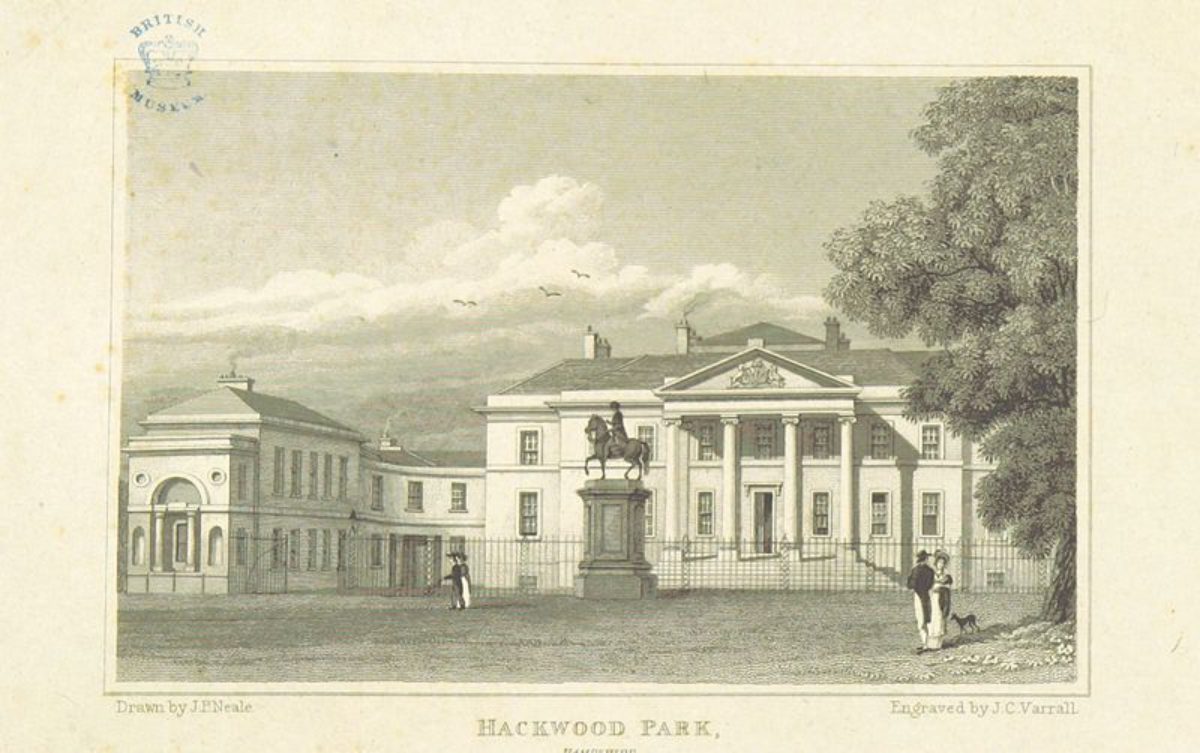
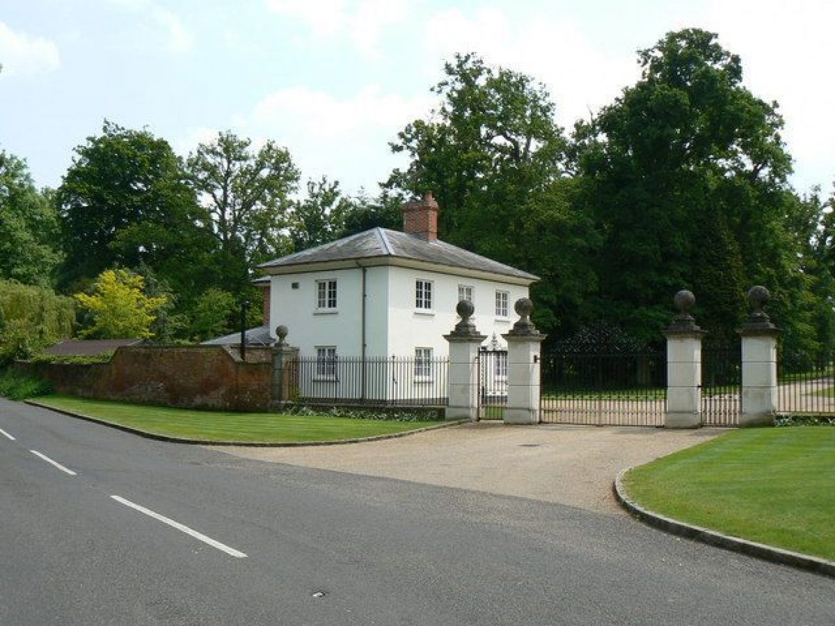
The main entrance to Hackwood Park is at the north-west corner, at Basingstoke Lodge, from which a drive enters through wrought-iron gates and runs south through the park to arrive at the western gateway in the curved ironwork screen (listed grade II) which encloses the forecourt on the north, entrance front of the house. The railed screen was erected between 1807 (Brown, Estate survey) and 1872 (OS) but was realigned and extended to its present northwards projection between 1872 and 1910 to encompass the previously free-standing equestrian statue of George I. The statue (1722, listed grade II) formerly stood south of the house. Some 200m north of the house, a fork off the drive follows a southerly course, passing the house on its west side and running alongside a walled ha-ha (first shown on Brown's plan of 1807) to serve the site of the former Shore Lodge (demolished 1970) on the southern site boundary.
Two further drives survive: that entering at Alton Lodge, on the A339 to the west of the house, is of C20 origin and was closed as a route to the house in 2000. The other drive, only a part of which is now in use, enters from the north boundary of the New Park on London Road (London Lodges and arch listed grade II). The M3 now cuts off the old drive just to the south of the London Lodges but the route formerly continued south through the New Park (now largely lost), and can be seen again crossing the Tunworth Road to Bridge Lodge on a brick bridge. It then swings south-westwards over a three-arched stone bridge (listed grade II) situated 600m from the house which spans a shallow grassy valley which was excavated for an ornamental lake in 1820-3; this had largely silted up by 1912 (OS).
In the late C17 and early C18, the house was approached by avenues from the north-west and north-east which formed part of the park's contemporary, formal landscape (Plan, 1683; Estate plan, c 1725-30). The Basingstoke Lodge drive was transformed to its present curve in the C19 (Brown, 1807; OS 1872) while Bridge Lodge drive (south of Tunworth Road), which first appeared as sketched proposal on an undated plan of the late C18 (c 1762-1807) (Hocking 1998), replaced an avenue (now gone) known as the Chestnut Walk which linked the house with Old Basing.
Principal Building
Hackwood House (listed grade II*) stands on a slight crest, west of centre within its park. The north elevation comprises two storeys with a central Ionic portico and, on each side, a lower, two-storey quadrant linking a forward-projecting five-bay wing. The south front features a giant portico without pediment while the east side is given an elaborate temple front with unfluted Ionic columns and a pediment, this being designed as a focus from the axis of the Broad Walk in Spring Wood. The whole house is encased in stucco and has a hipped, tiled roof.
The first building at Hackwood was probably a hunting lodge built in the C16 which, following the destruction of the Powletts' house at Old Basing, appears to have been enlarged and refitted. The present house was erected by the first Duke between 1683 and 1687 (Pevsner and Lloyd 1967). It was substantially altered for the first and second Lords Bolton from 1800 to 1813 by the architect Lewis Wyatt (c 1751-1853), nephew of Samuel Wyatt (1737-1807) who had begun the work for the first Lord Bolton.
Gardens and Pleasure Grounds
The principal pleasure ground lies to the east of the house within Spring Wood although the south side of the house has a formal garden setting. The south front opens onto a broad terrace comprising a gravelled walk and lawns, formerly enclosed from the South Park by post and rail fencing (removed 2001). A central sundial flanked by two basins with fountains was moved here in the 1960s from the walled garden.
At the west end of the lawns are a swimming pool, designed in 1936 by Jellicoe, Page and Wilson and constructed by William Wood and Son Ltd, and a tennis court beyond. The lawns were levelled to their present form between 1807 and 1817 (Hocking 1998), the south front in the early C18 overlooking two formal terraces of an enclosed grass parterre ending in an amphitheatre and, southwards below it, a further enclosure containing a rectangular reservoir flanked by tree-lined walks, the whole layout following closely that shown on the plan of the early 1720s (Bodleian Library) attributed to Charles Bridgeman. William Brown's estate plan of 1807 shows only the reservoir and the statue of George I surviving into the early C19.
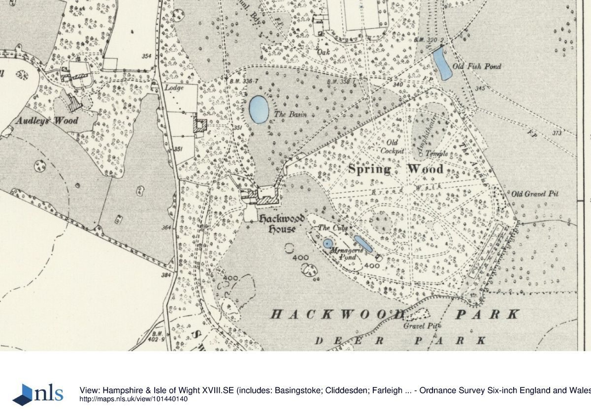
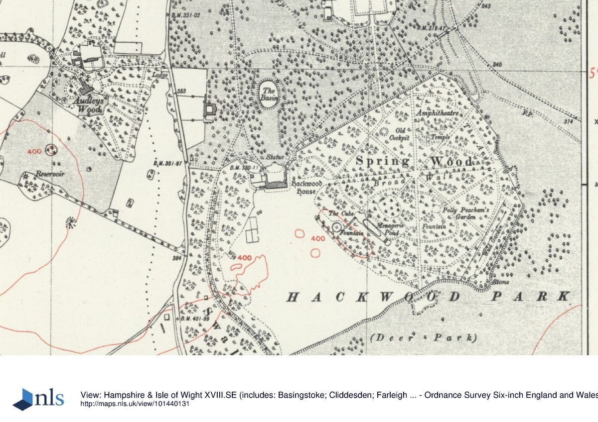
On the axis of the east front, a mown grass path leads 130m to a gateway, moved here in the late C20 from the London Lodges, which marks the western entrance to Spring Wood. This roughly crown-shaped wood of c 32ha is enclosed from the park by a combination of raised terraces, ha-ha walls, and fencing, its ground sloping steeply down from the house eastwards towards the park. Within the formal structure of a star-shaped pattern of hedge-lined radial walks focused on a central rondpoint with a statue of Flora (listed grade II), the woodland, which comprises informally planted trees of mixed ages and species with an understorey of flowering shrubs and bulbs in grass, is laid out with a series of terrace walks, cabinets de verdure (hedge-enclosed garden rooms), garden buildings, and water features.
The origin of Spring Wood was probably as an early medieval woodland, enclosed by a park pale for the control of deer. By the late C17 it had been cut through by an east to west ride, on the line of the present Broad Walk, and featured a ride around the perimeter (Smith plan, 1683). These rides, developed in the late C17 or early C18 to the present radial star, are shown on the annotated plan of the early 1720s attributed to Bridgeman (Willis 1977) which may represent a survey of an existing layout used by Bridgeman to indicate his proposals for the construction of military-style fortifications, canals, a 'tarrace, stoccade and fossee', and 'parapett yew hedges'.
A further, larger-scale plan of the same date, also attributed to Bridgeman, shows these features with the addition of several garden rooms including an amphitheatre, menagerie, and French garden. These, with the complete enclosure of the Wood by raised terraces and bastions, are shown as constructed (although with the gardens in different positions) on the estate plan of c 1725-30. Although Spring Wood has been altered since the early C18 by the introduction of exotic conifers in the C19 and in the C20 by the rearrangement of features and replanting after significant storm damage in 1987 and 1990, it survives essentially as an C18 designed ornamental woodland.
The following summary description of Spring Wood follows an anticlockwise route around a perimeter walk which runs through each of eight sectors defined by eight radial walks, beginning at the wrought-iron gates at the western (9 o'clock) entrance. The proper names given to the walks and a number of the features refer to a 1985 plan of Spring Wood prepared by Lord Camrose (copy in Hocking 1998). Some 130m south of the gates is the Fountain Pool, built 1807-17 (ibid) and containing a fountain of four dolphins (listed grade II). A C19 ashlar garden bench (listed grade II) stands adjacent.
Some 50m to its north-east are two small pavilions known as The Cubs (listed grade II), first recorded on William Brown's plan of 1807. These frame the north-east end of the Menagerie Garden which is shown on the estate plan of c 1725-30 constructed to the design on the plan attributed to Bridgeman of the early 1720s. It contains a rectangular pool with an urn at each corner (listed II) which is set in grass and enclosed by hedges and, at the south-east end, is overlooked by a pavilion (1727, listed grade II*) designed by James Gibbs (1682-1754). Some 50m north-east of the Menagerie is the Tea Garden, a circular grassy glade established by 1807 (Brown) which contains a circular pool excavated c 1994 and, on its north-west edge, a pavilion (listed grade II) of C19 and C20 origin erected on the site of a former Victorian garden building (Hocking 1998).
Running for 550m along the south-east perimeter of this sector to end at the surviving early C18 Mount is Beechy Walk, a grassed avenue planted in the 1820s following the removal of Bridgeman's South Terrace and largely replanted after the storm of 1987. An urn on a pedestal (listed grade II) marks its intersection with the north-to-south 12 o'clock avenue. From the Mount, Cathedral Avenue runs c 240m north-eastwards along the surviving early C18 East Terrace. This former beech avenue was replanted with London planes in 1988 following storm damage. Parallel, below the terrace on its north-west side and on the site of Bridgeman's formal canal, a watercourse with several pools and ornamental shrubbery forms a Chinese garden (also known as the Wild Garden). In the base of the canal stand three late C19 or early C20 stone lanterns carved in the Japanese manner (listed grade II) and, at the north-east end of the garden, an octagonal pavilion erected in 1982.
From the Chinese garden, a radial path known as Polly Peachum's Walk, its entrance framed by a pair of pineapples on pedestals (listed grade II), leads c 100m north-westwards to Polly Peachum's Garden which occupies the site of Bridgeman's French parterre garden. The present timber pavilion by the firm of Machin was erected in 1987 on the site of a C19 building, James Gibbs' previous Greek cross-shaped pavilion having gone by 1877 (ibid). At the south-east end of the garden is a fountain (listed grade II) which survives from the Bridgeman layout, its present central urn replacing a statue of Bacchus (now housed outside Spring Wood, near the house, listed grade II).
Some 120m north-north-west of the Chinese garden pavilion, the eastern end of the Broad Walk, the principal east-to-west walk, terminates in Temple Pool, an oval pool with a central rotunda constructed in the late 1970s in the style of a Vardy drawing that hung in the house (Lord Camrose's staff pers comm, 1998). The pool stands just to the west of the site of an C18 cross canal. Bridgeman's grass amphitheatre, laid out on a north-east to south-west axis, lies some 250m north-west of Temple Pool and is enclosed from the park by a perimeter horse chestnut avenue with an urn on a pedestal (listed grade II) at either end.
The open grassed floor of the amphitheatre lies at its north-east end and features a statue of a draped female on a plinth (moved from its former site on The Mount at the north end of Cathedral Avenue in 1987, listed grade II). From the floor, a series of grassed terraces, flanked by mature conifers, rises south-westwards up a slope to the site of James Gibbs' early C18 Rotunda (listed grade II as The Temple), now (1998) comprising only eight free-standing columns. The north-west sectors of the star, enclosed from the park by the surviving early C18 North Terrace, contain a sunken, level-floored circle within a surrounding bank of mature yews known as the Cockpit; a vase on a plinth (listed grade II) stands in the centre. A further vase (listed grade II) stands some 50m to the south-east, at the junction of the radial Cockpit Walk and perimeter Ashton's Walk. The vases formerly stood, along with those that remain in situ, along the top of the walls of the kitchen garden.
Park
Northwards from the house and Spring Wood, to the kitchen garden and Home Farm, much of the North Park is planted and managed as wood pasture, its clumps and scattered trees of mixed ages and species enclosed within chain-link fencing and grazed by deer. This area formed the late C17 `Wood with Walks in It' (Hocking 1998), the formal avenues replaced by the early C19 by the present criss-cross of drives. Some 200m north of the house, on its main axis, lies the oval Basin, now (1998) dry and ringed by mature limes, the early C18 axial vista of which it formed a focal feature having gone by the early C19. West of the Basingstoke Lodge drive, some 60m north-west of the house, stands the early C19 courtyard Stable Block and Riding School (listed grade II*), probably built by Lewis Wyatt; these are now (1998) in both residential and stabling use. Adjoining their west side is a series of early C19 walled paddocks with brick field shelters.
The north-west corner of the park, eastwards as far as the early C19 Keeper's Cottage (listed grade II), is down to pasture with a few scattered trees while to the north-east of the walled kitchen garden is Hackwood Home Farm, its massive brick barn, aisled cartshed, and red-brick farmhouse dating from the C18 and early C19 (all listed grade II). Two C18 or early C19 domed icehouses (listed grade II) stand c 10m and 25m north-east of the north end of the kitchen garden. Associated with the farm to the east is a pair of late C18 brick cottages (Daisy and Rose Cottage) and the Mill House (all listed grade II). North of the farm, the New Park, which is cut by the east to west route of the M3, extends from the Tunworth Road north to London Road. Its layout of woodland plantations enclosing grassland, in use now (1998) as a point to point course, was established in the early to mid C19 when it became part of Hackwood Park.
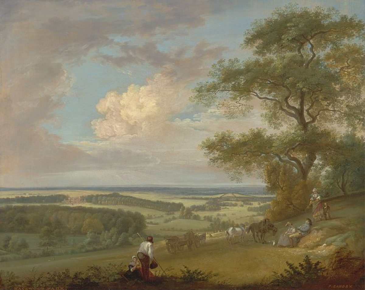
East of Home Farm, across the area known as The Pelican to the site boundary, the park is open in character and under arable cultivation, with a number of small woods, largely of C20 origin, planted as game coverts. Known as Hunting Park Hill by 1807 (Brown), this area had become part of the deer park by the late C18 and its covering of scattered trees, densest over The Pelican, survived until cleared and ploughed up during the Second World War. Similar arable use with game coverts extends southwards to the site boundary.
South of the house, open parkland slopes, which replaced the formal C18 terraces in the early C19, are enclosed to the south and west by an early C19 brick ha-ha. West beyond Paradise Wood Drive, the early C19 Paradise Wood is now laid to grass following storm damage in 1987. Further south, Swallick Wood, probably taken into Hackwood's ownership in the early C18 (Hocking 1998), was largely replanted following storm damage. The Wood extended further east in the C18 and is shown on the estate plan of c 1725-30 as cut by the continuation south of the main axial vista on the house. This, with two additional vistas forming a goose-foot, survived in 1807 (Brown) but had gone by 1872 (OS).
Kitchen Garden
The kitchen garden lies 500m north-east of the house. It consists of a rectangle 200m x 100m, which is enclosed by high red-brick walls (listed grade II) with piers surmounted by stone vases, several of which are now in Spring Wood. The southern wall is pierced by a section of railings with gates. The garden, which is shown on the OS surveyor's drawing of 1792, is divided internally by a central east-to-west wall, the northern half being further, similarly, subdivided (all internal walls listed grade II).
A gardener's house, known as The Bothy (listed grade II), is built onto the outside of the northern perimeter wall with access via French windows into an Orangery (listed II) on the south, internal side of the wall. The northern internal east-to-west wall has lean-to sheds on its north side and glass against its western end, with a further range of detached glasshouses in the north-west corner of this part of the garden (all sheds and glass listed grade II). The southern sections of the garden are laid to grass and an axial avenue leads from the extreme southern end to Spring Wood (Hocking 1998).
Maps
- T Smith, Topographical Description of the Lands .. of Hackwood Park .., 1683, (392/2, copy), (Hampshire Record Office)
- C Bridgeman (attrib), Hackwood (two plans), early 1720s (Gough Collection MSGD a3 fo.4, a4 fo.34), (Bodleian Library)
- Hackwood Estate Plan, c 1725-30 (private collection)
- W Brown, A Plan and Survey of Hackwood Park ..., 1807, (392/3, copy), (Hampshire Record Office)
- Lord Camrose, Plan of Spring Wood for Open Days, 1985 (private collection)
- OS Surveyor's drawing, 2" to 1 mile, 1792 (British Library Maps)
- OS 6" to 1 mile:
- 1st edition surveyed 1871-2
- 2nd edition published 1897
- 3rd edition published 1912-13
- OS 25" to 1 mile:
- 1st edition surveyed c 1872
- 2nd edition published 1896
- 3rd edition published 1910
- 1932 edition
Description written: June 1998 Amended: September 2000; January 2002
Register Inspector: VCH
Edited: January 2004, January 2022
- Visitor Access, Directions & Contacts
Access contact details
A public footpath passes through the grounds of Hackwood Park, so although it is a private property it is still there for walkers to enjoy.
- History
The following is from the Register of Parks and Gardens of Special Historic Interest. For the most up-to-date Register entry, please visit The National Heritage List for England (NHLE):
13th Century
Hackwood formed a wooded part of the manor of Eastrop until its enclosure as a deer park in 1223.
16th Century
By the C16 it was in the possession of William Powlett, first Marquess of Winchester and owner of nearby Basing House (qv), who built a hunting lodge in the park. Following the destruction of Basing House during the Civil War, the lodge was enlarged and a formal landscape laid out in the park.
17th - 18th Century
The sixth Marquess, created first Duke of Bolton in 1689, built a new house between 1683 and 1687 and possibly began the formal treatment of Spring Wood. He was succeeded by his son in 1699 and it was during his period of ownership and that of the third Duke, from 1722, that the landscape of Hackwood, and of Spring Wood in particular, was further developed with walks, canals, radiating avenues and ramparts to a plan of c 1725-30 attributed to Charles Bridgeman (d 1738) (Willis 1977) and with garden buildings by James Gibbs. The Bolton title was extinguished with the death of the sixth Duke in 1794 and Hackwood passed to the illegitimate daughter of the fifth Duke, Jean Mary Brown Powlett. On her marriage to Thomas Orde in 1795, he assumed the name Powlett and was created Baron Bolton in 1797.
19th Century
He and his son William altered and enlarged the house in the early C19 and made changes to informalise the landscape although the formal structure of Spring Wood and the avenues in Swallick Wood were retained. The park was also extended northwards to include the New Park (north of Tunworth Road). From the mid C19, Hackwood was tenanted.
20th Century
Hackwod was occupied by Lord Curzon from 1906 to 1925 before finally being sold, in 1936, to Lord Camrose. The house was in use as a military and then a civilian hospital during and after the Second World War.
In 1965, the second Lord Camrose inherited the house and the major portion of the park, the New Park passing to his brother, the Hon Julian Berry. The estate remains in private hands apart from Crabtree Plantation, which became detached with the building of the M3 and is now owned by Basingstoke and Deane Borough Council. Lord Camrose rearranged and added to the features in Spring Wood and carried out extensive replanting following the storms of 1987 and 1990. Following his death in 1995 and that of his wife in 1997, Hackwood was put up for sale.
21st Century
As of 2021, Hackwood Park is in limbo with no residents currently present, though the house and grounds are being maintained.
- Associated People
- Features & Designations
Designations
The National Heritage List for England: Register of Parks and Gardens
- Reference: GD1276
- Grade: I
Features
- House (featured building)
- Description: The house replaced an earlier hunting lodge. It was enlarged in the early-19th century.
- Earliest Date:
- Latest Date:
- Walk
- Terrace
- Key Information
Type
Park
Purpose
Ornamental
Principal Building
Domestic / Residential
Survival
Extant
Hectares
400
Open to the public
Yes
Civil Parish
Winslade
- References
References
- {English Heritage Register of Parks and Gardens of Special Historic Interest}, (Swindon: English Heritage, 2008) [on CD-ROM] Historic England Register of Parks and Gardens of Special Historic Interest
- Willis, P., {Charles Bridgeman and the English Landscape Garden} (London: Zwemmer, 1977), pp. 184-7 Charles Bridgeman and the English Landscape Garden
- Pevsner, N. and D. Lloyd, {The Buildings of England: Hampshire and the Isle of Wight} (Harmondsworth: Penguin, 1967), pp. 260-2 The Buildings of England: Hampshire and the Isle of Wight
- Page, W. {Victoria County History: Hampshire and the Isle of Wight, Volume 4 } (London: Constable, 1911), pp. 122-3 Victoria County History: Hampshire and the Isle of Wight, Volume 4
- Gibbs, J., (1728) Book of Architecture, containing designs of Buildings and Ornament
- Vol 13 (10 January 1903), pp 48-54; 33 (17 May 1913), pp 706-14; (24 May 1913), pp 742-50 Country Life
- R Watson Picarle et al, (Architectural Association 1991) Hackwood Park Hampshire, Its History and Future
- Hocking, S., (report for Hampshire County Council 1998) Hackwood Park, Historic Landscape Restoration and Management Plan
- Related Documents
-
CLS 1/379/2
Landscape Conservation Plan - Digital copy
Elizabeth Banks Associates - 2001
-
CLS 1/380
Landscape Conservation Plan: Figures, Plates and Appendices - Digital copy
Elizabeth Banks Associates - 2001
-
CLS 1/379/2