Introduction
Gayhurst Court is an 18th-century landscape park and woodland developed on a site which originated in Anglo-Saxon times. At their most extensive the grounds covered about 300 hectares, with mid-19th century formal gardens of 1 hectare. The park and residence are now in divided use.
Terrain
The site is in the low-lying, gently undulating valley of the River Great Ouse.www.historicengland.org.uk/listing/the-list
An C18 landscape park and mid C19 formal gardens surrounding a C16/early C17 country house; the park was probably laid out by Lancelot Brown c 1750-60, with modifications by Humphry Repton c 1793. The site was visited frequently by the C18 poet William Cowper.
DESCRIPTION
LOCATION, AREA, BOUNDARIES, LANDFORM, SETTING
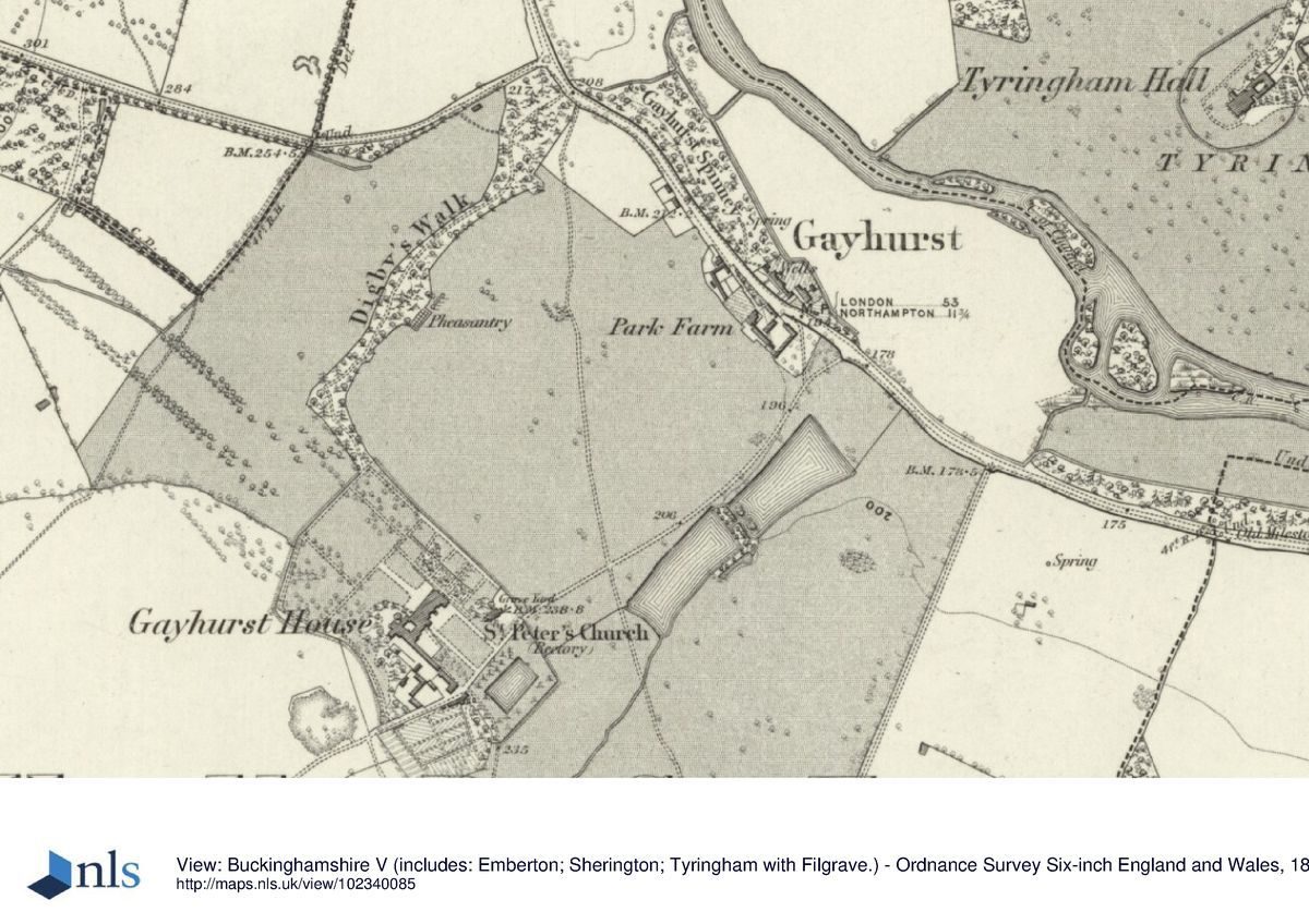
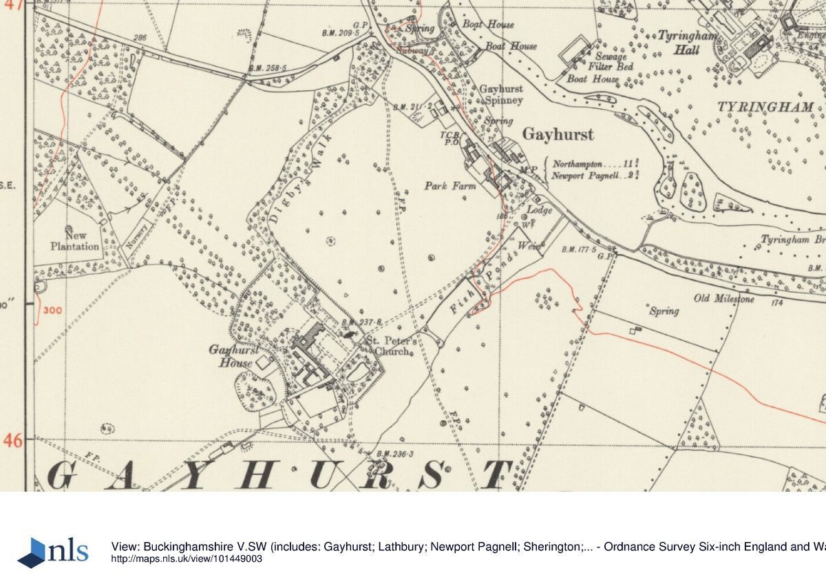
Gayhurst Court lies in rural north Buckinghamshire, 3km north-west of Newport Pagnell and 1km south-west of the adjacent estate of Tyringham, in the low-lying, gently undulating valley of the River Great Ouse. The 100ha site is bounded to the east by the Gayhurst to Haversham Lane, to the north-east by the River Great Ouse, to the north-west by the B526 from Newport Pagnell and other adjoining lanes, to the west by Gayhurst and Bunsty Woods, and to the south-west by agricultural land. The small village of Gayhurst which lies along the B526 was removed from the vicinity of the house in the early C18. The B526 bisects the northern half of the site and the M1 motorway runs parallel to the south-west boundary 0.5km to the south-west, crossing Gayhurst estate land. The setting is largely agricultural, with the ornamental parkland of the Tyringham estate to the north-east.
ENTRANCES AND APPROACHES
The main, north-east drive enters 600m north-east of the house, off the B526, past a mock Elizabethan lodge (listed grade II) converted in 1882 from a lodge of 1751 and given two turrets moved from the Brown/Repton bathhouse (see below). Until 1995 it also ran past the Sir Francis Drake public house. The drive initially runs through trees, before emerging into the open northern parkland with a clear view of the house rising over the undulating hillside; it passes close to the north-west side of the two park ponds. It continues more or less due south-west to the south side of the church and the entrance forecourt. The forecourt consists of a large rectangular panel of lawn, surrounded by the gravel drive which leads to a gravel sweep in front of the main, south-east entrance of the house. The forecourt is bounded to the south-west by the service wing, to the north-east by the church and churchyard and to the south-east by a pond and its surrounding garden. The area was formalised in the mid C19 when a drive curving around the north end of the lawn was altered to the current shape. At the south end of the forecourt the drive continues west giving access to the service yards to the north and kitchen garden to the south.
A second drive across the south park enters at the southern corner of the site, off the Haversham lane, with a clear view of the main front of the house and church tower amongst trees seen across gently falling parkland. This south drive runs north-west across the park towards the house. The northern section now curves west to Dairy Farm, previously called Gayhurst Farm, instead of to the east, where formerly the drive entered the garden through the site of the present sewage plant, giving access to the forecourt (this section now (1997) gone).
PRINCIPAL BUILDING
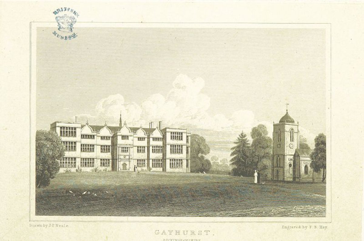
Gayhurst Court (House) (listed grade I), which lies at the centre of the site, was enlarged from an early C16 building by William Moulsoe from 1597. The work was completed by Sir Everard Digby some time before 1606, when he was executed for his part in the Gunpowder Plot, creating an E-shaped stone house with a three-storey porch on the south-east side. The house was altered in the early C18 for George Wrighte, who filled in the space to the north between the two projecting wings. Further alterations took place in the 1860s, for the second Lord Carrington, using William Burges who also added several service buildings close to the house including the circular, male servants' lavatory (listed grade II), based on the Abbot's Kitchen at Glastonbury. The house was converted to flats in the 1970s. The house has views south-east over the south park, north-west across the park to Gayhurst Wood and north-east across the park to the tree belt along the village boundary.
The C17 service wing and stables (listed grade II*), with additions by Burges c 1860, are attached to the south corner of the house and consist of a long, stone, two-storey south wing, known as The Mews, extending along and forming the south-west boundary of the main entrance forecourt, as well as the north-east boundary of the service court. The Mews has been converted to domestic accommodation, with associated modern garages and other outbuildings to the north-west and south-west. At the south end a detached, square, C17 stone dovecote (listed grade II*) of two storeys with a cupola, now a house, lies on the south side of the drive, at the south corner of the forecourt.
The parish church (listed grade I) lies 50m east of the house, surrounded by a small graveyard, on the site of a medieval church demolished in 1725 and rebuilt by George Wrighte c 1728 in stone in a baroque, Wren-style composition, with a prominent lead-covered cupola on the tower.
GARDENS AND PLEASURE GROUNDS
The gardens surround the house, with pleasure grounds known as Digby's Walk running north from the house through the park. North-west of the house a flat lawn, with two hard tennis courts, is bounded to the north close to the house by a clipped yew hedge with carved stone pedestals in niches (William Burges c 1860, listed grade II*), an extension of a similar feature in the forecourt running south-east from the north-east front of the house. North of the lawn and the clipped yew hedge, a small grove of mature yews separates the lawn from the northern park. The north-west lawn extends for 100m north-west and then for a further 100m of paddock to a ha-ha, with a view into the park along the course of a mid to late C19 elm avenue (now gone) across a symmetrically curved dip in the park landform (possibly a Brown feature), which extends the view towards Gayhurst Wood. North-east of the house lies an open geometric parterre consisting of two adjacent clipped box parterres close to the house, with a flat rectangular lawn (possibly having lost its detail) beyond and the remains of a ha-ha separating it from the park. This arrangement, dominated by the church tower to the south, is the remains of part of Burges' c 1860s garden layout. Leading north is an area of mature trees sited at the south end of Digby's Walk.
Digby's Walk is a narrow ribbon of pleasure grounds curving north from the north corner of the gardens, along the west edge of the northern section of the park, with a yew-lined path curving from side to side, taking advantage of views to west and east. This leads to a crossing under the B526 through a brick-vaulted tunnel fronted by an elaborate, stone, gothic-arched facade (H Repton c 1793, listed grade II*), with a pond several metres to the north feeding a cobbled stone channel (overgrown) which disappears under the tunnel. The tunnel emerges on the north side of the road through a rustic stone facade into ornamentally planted woodland known as Gayhurst Spinney, which has the remains of several paths running through it. One, situated at the north end of the woodland, reaches a stone pedestal (dated 1751) and reproduction urn surrounded by iron railings (C18, listed grade II), with a hole at the bottom where a chalybeate spring (water rich in iron, used historically to bathe the eyes) emerges.
A heart-shaped pond lies south-east of the forecourt, now largely silted up with reeds growing in it and shrubs surrounding it; this was formerly at the centre of a late C19 water garden, and may have been part of an C18 water garden, possibly with formal yew walks as several large yews survive here. The whole garden, except the kitchen garden, is surrounded by the remains of a stone ha-ha, the wall in good condition on the south-west boundary, but in poor condition along the remaining sections.
PARK
The park is split in to two discrete sections by the B526. The southern area, surrounding the house, is pasture with largely C20 trees. The site of a double avenue of elms runs north-west from the north-west garden, with associated earthworks including a level platform c 400m north-west of the house, a cutting through ground which rises away from the house to reveal Gayhurst Wood beyond, and a deep ditch along the fence line which bisects the site of the avenue about half way along it. Gayhurst Wood bounds this area to the west, with, to the east, Digby's Walk overlooking this part of the park. North-east of the house is a self-contained open area of park, bounded on the north-west by Digby's Walk and to the south-east by the two large rectangular fishponds which probably predate the Brown landscaping works. The northern pond is silted up at its south end, with trees growing in it. The park to the east of the site is open pasture with scattered trees while that to the south is arable land.
North of the B526 a path leads north from the chalybeate spring in Gayhurst Spinney into fine parkland, now lacking trees, north of the spinney and directly overlooking the river, with a stone bathhouse (C18, listed grade II, much extended 1990s) in the middle, dated 1751 and possibly by Brown, embellished by Repton. From here there are excellent views over the Tyringham estate and towards Tyringham House and bridge. South of the spinney a large open water meadow, bounded by the road and the river, visually connects the Gayhurst parkland with that of Tyringham, with views of Tyringham House, bridge and park across the river. It is probable that Repton, when working on both estates c 1793, intended to use the adjacent views across the Tyringham parkland as a borrowed landscape, connecting Gayhurst House with the river by using Digby's Walk to and through the spinney, and taking advantage of these views and walks to the open land to north and south with incidents such as the Spring and two boathouses (now gone). Brown worked here however c 1751 and it is difficult, because of a lack of contemporary plans or a Repton Red Book, to distinguish between the work of the two designers.
KITCHEN GARDEN
The stone-walled kitchen garden lies at the southern corner of the garden, 100m south of the house. Its C18 north wall (listed grade II) has a C16 stone Tudor arch inserted near the centre. Three houses have been built in the walled garden, retaining parts of the perimeter walls.
REFERENCES
Country Life, 13 (17 January 1903), pp 80-6
Records of Bucks 20, (1977), p 442
D Stroud, Humphry Repton (1962), p 81
G Carter et al, Humphry Repton (1988), p 148
Janet Jack, Gayhurst: a study of the park and gardens, and recommendations for conservation, (unpub dissertation, Architectural Association 1993)
N Pevsner and E Williamson, The Buildings of England: Buckinghamshire (1994), pp 335-8
Maps
Tithe map for Gayhurst parish, 1850 (Buckinghamshire Record Office)
OS 6" to 1 mile:
1st edition published 1885
2nd edition published 1900
3rd edition published 1926
OS 25" to 1 mile:
1st edition published 1880
2nd edition published 1900
Description written: 1997 Amended: April 1999
Register Inspector: SR
Edited: June 1999
- Visitor Access, Directions & Contacts
Directions
Between the M1 and B526, north-west of Newport Pagnell.
- History
The following is from the Register of Parks and Gardens of Special Historic Interest. For the most up-to-date Register entry, please visit the The National Heritage List for England (NHLE):
www.historicengland.org.uk/listing/the-list
HISTORIC DEVELOPMENT
A medieval deer park existed, probably sited south-west of the house, in the vicinity of Hoo Wood (Records of Bucks 20, 442), and is shown on John Speed's county map of 1610. The Nevill family owned the estate during the C15 and much of the C16, building the oldest part of the present house c 1500 on the site of an older manor house. The Digby family owned the property from 1596 to 1704, when it was bought by George Wrighte. His son George II built the church, removed the village to the Newport Pagnell to Northampton turnpike and brought in Lancelot Brown (1716-83) to landscape the park, probably c 1751, around the time Brown left Stowe (qv) to set up his own practice. George Wrighte III employed Humphry Repton (1752-1818) c 1793 on alterations to the pleasure grounds and park, probably at the same time as he was working on the landscape at Tyringham (qv). If one was indeed produced, the whereabouts of the Red Book for Gayhurst is unknown, but Repton mentioned his work here in his published volume Sketches and hints on landscape gardening (1794), quotes including:
The water in the park, though it consists of several pieces of different levels has the effect of being one single sheet when seen from the house: this was very ingeniously executed by Mr. Brown; but I have also connected the neighbouring river and the park, by means of a dressed walk which passes under the turnpike road; and the banks of this river are worthy of every effort to make them a part of the beautiful scenery of the place.
The property was let to the second Lord Carrington from 1842 to 1877, during whose tenancy elaborate additions and alterations were made to the house and garden. During the Second World War the house and grounds were used as an outstation for Bletchley Park's decoding activities and various buildings were erected in the park (now, 1997, gone). In the 1970s the house and service buildings were converted to houses and flats.
- Associated People
- Features & Designations
Designations
The National Heritage List for England: Register of Parks and Gardens
- Reference: GD1590
- Grade: II
Features
- Lake
- Dovecote
- Walk
- Vase
- House (featured building)
- Description: The house was much-altered in the mid-19th century.
- Earliest Date:
- Key Information
Type
Park
Purpose
Ornamental
Principal Building
Domestic / Residential
Survival
Extant
Hectares
100
Open to the public
Yes
Civil Parish
Gayhurst
- References
References
- Carter, G et al {Humphry Repton landscape gardener} (1988) p 148 Humphry Repton landscape gardener 1752-1818
- {English Heritage Register of Parks and Gardens of Special Historic Interest} (Swindon: English Heritage 2008) [on CD-ROM] Historic England Register of Parks and Gardens of Special Historic Interest
- Stroud, D {Humphry Repton} (1962) p 81 Humphry Repton
- Pevsner, N and Williamson, E {The Buildings of England: Buckinghamshire} (1994) pp 335-338 The Buildings of England: Buckinghamshire