Introduction
Gawthorpe Hall features a landscape park of about 35 hectares, with Elizabethan-style gardens of about one hectare. The formal gardens were designed by Sir Charles Barry for Sir James Kay-Shuttleworth during the period 1850-6 incorporating some elements of earlier 19th-century work.
Terrain
The Hall stands on a platform some 50 metres from the banks of the River Calder and the land rises gently to the south and south-east from the riverbank.www.historicengland.org.uk/listing/the-list
Formal gardens designed by Sir Charles Barry for Sir James Kay-Shuttleworth during the period 1850-6 incorporating some elements of earlier 19th-century work.
DESCRIPTION
LOCATION, AREA, BOUNDARIES, LANDFORM, SETTING
Gawthorpe Hall is situated on the north-eastern edge of Padiham. There is open agricultural land on the north-west, north and east sides of the site. The Hall stands on a platform c 50m from the banks of the River Calder and the land rises gently to the south and south-east from the riverbank. The boundary is formed by C20 fencing of various types along the edges of woodland.
ENTRANCES AND APPROACHES
There are two main entrances, both with Jacobean-style stone lodges (listed grade II) of c 1850, probably designed by Charles Barry (1795-1860). Stockbridge Lodge is situated on the north side of Burnley Road c 750m from the centre of Padiham. Stockbridge Drive leads north-eastwards to the Hall; it is shown on an estate map of 1816 and an avenue is shown along part of its length on the 1st edition OS map published 1848. A double avenue begins c 100m north-east of Stockbridge Lodge. It becomes a single avenue which is lost as the drive enters woodland. Habergham Lodge is situated on Padiham Road, c 800m east of Stockbridge Lodge. A drive leads north-westwards to the Hall. An opening in the north side of a wall surrounding All Saints church, c 80m west of Habergham Lodge, leads to paths through woodland which run northwards to connect with Habergham Drive. A secondary entrance, consisting of primary and secondary gate piers flanking Gothic Revival-style iron gates (listed grade II), is situated on the drive c 350m south-west of the Hall. Habergham and Stockbridge Drives meet at a point c 50m south-west of the Hall and continue, through C20 gates flanked by shaped slabs with the words ?Shuttleworth Gawthorpe? inscribed upon them, to the principal entrance on the south side of the Hall.
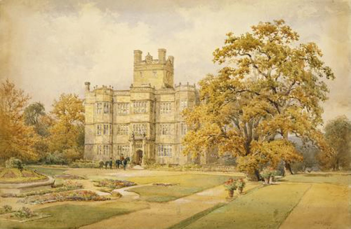
PRINCIPAL BUILDING
Gawthorpe Hall (listed grade I) was built 1600-5 for Rev Lawrence Shuttleworth. The chief mason was Anthony Whitehead and although there are no records in the accounts of payments for drawings or a plan it is thought that the house was designed, or based on designs, by Robert Smythson (Girouard 1983). In 1849-51 Sir Charles Barry made various internal and external alterations including the addition of a Jacobean-style stone balustrade around the house. This was part of Barry's scheme to rectify what he described as 'a fine picture without a frame' and is integral to the formality of the gardens which were created on the north, east and south sides of the Hall.
Some 80m west of the Hall there is a range of estate buildings around a yard. These consist of the Great Barn of 1605 (listed grade I), a former coach house of c 1870 (listed grade II) attached to the south side of the barn, and an L-shaped range opposite the coach house (listed grade II) which consists of estate buildings with C17 origins which have been altered at various times in the C18, C19 and C20. These have been converted for various office, conference and restaurant uses. The yard is enclosed on the north and west sides by a wall (listed grade II) with gate piers and a doorway at the south-west angle.
GARDENS AND PLEASURE GROUNDS
The north front of the Hall overlooks the River Calder, which was diverted away from the building in the C18 owing to its polluted condition. It was restored to the original course in the 1960s. A balustraded terrace (listed grade II) in front of the Hall bows outwards around a semicircular radial parterre. On each side of this there is a balustraded terraced walk which terminates to both east and west with an ornamental seat surmounted by Jacobean-style cresting. In the stonework above the eastern seat there is a carved inscription with the words 'Kynd Kynn Knawne Kepe', the Kay family motto. A corresponding inscription on the western seat reads 'Prudentia et Iustitia', which is the Shuttleworth motto. The balustrading is similar in style to the balustrade around the Hall and this part of the garden was designed by Charles Barry in c 1850. His son Edward designed the seats. A view of 1847 (guidebook) shows that this arrangement replaced a terraced walk with balustrading which overlooked the riverbed.
Stone steps lead up from the garden on each side of the Hall. These have stone urns decorated with encaustic tiles designed by A W N Pugin.
On the east side of the Hall is the Rose Garden which consists of a geometrical parterre which was restored in the late C20 to a simplified form of the original parterre, which was designed by Barry.
On the south side of the Hall a D-shaped gravelled area is aligned with the central main entrance. A formal garden designed by Barry c 1852-6 consists of a central rectangular lawn which was laid out as an elaborate geometrical parterre, shown in a photograph of c 1900 (private collection). Part of the design can be seen as parch-marks in the grass. Paths lead around the perimeter and terraces on the east and west sides of the lawn are reached by stone steps. More stone steps lead to secondary terraces on each side. Aligned with the front of the Hall, c 50m south of the entrance, there is a flight of stone steps with urns, again decorated with tiles by Pugin, which lead up to a terrace, and a walk slopes upwards to a further, narrower flight of steps aligned with the first. This arrangement gives the vista up the steps and terraces added depth by exaggerating the perspective. Both terraces have gravelled walkways which join with Habergham Drive c 80m to the west, and curve around on the east side of the garden to lead back to the Hall entrance.
On the west side of the Hall the earth is banked up to conceal an entrance to the basement and a mid C19 game larder (listed grade II) c 40m west of the Hall. A belt of trees partially screens the barn and estate buildings.
The garden is surrounded by woodland with ornamental underplanting which provides a backdrop and gives closure to the garden. A painting attributed to Leonard Knyff (guidebook) of early C18 date shows that the garden on the south side of the Hall at that time was walled and laid out with formal rectangular flower beds. A map of 1816 which was made for Robert Shuttleworth when he moved to Gawthorpe suggests that the garden shown by Knyff was one of several walled compartments ranged around the Hall. By the time the view of 1847 was made, the gardens had been removed and grassland with clumps of trees surrounded the Hall on the north and east sides. The 1816 map shows that an L-shaped plantation sheltered the Hall on the north and east sides; this planting was extended during the C19.
KITCHEN GARDEN
The kitchen garden is situated c 250m south-east of the Hall and it occupies an area marked 'gardens' on the 1816 map. It is reached via a path which leads through woodland from the Hall. The garden has a range of stone cottages and bothies along its north side which have been converted to two houses. Some 10m to the east of the garden is a tall circular brick chimney. The outer face of the east wall is of stone with stone buttresses. The other walls and all inner walls are of brick. Part of the wall in the south-west corner of the garden has been demolished. The main entrance to the garden is between the two houses on the north side where there is a rustic stonework tunnel. A map of 1921 (Cave) shows that this was enclosed with glass and that it led through to glasshouses along the north side of the garden.
REFERENCES
Maps
Estate Map, 1816
C Greenwood, The County Palatine of Lancaster, 1818
OS 6" to 1 mile: 1st edition surveyed 1844-7, published 1848; 2nd edition published 1909-10
OS 25" to 1 mile: 2nd edition surveyed 1890-1
Plan accompanying the lease of the kitchen garden to Thomas Cave, 1921
Description written: May 1997
Amended: June 1998
Edited: March 1999
- Visitor Access, Directions & Contacts
Telephone
44 1282 771004Access contact details
The gardens are open daily all year, 10am to 6pm. Please see: http://www.nationaltrust.org.uk/place-pages/138/pages/opening-times-calendar 01282 771004
Directions
On the east side of Padiham, north of the A671.
- History
The following is from the Register of Parks and Gardens of Special Historic Interest. For the most up-to-date Register entry, please visit the The National Heritage List for England (NHLE):
www.historicengland.org.uk/listing/the-list
HISTORIC DEVELOPMENT
Gawthorpe originated as a small agricultural settlement within the Royal Forest of Pendle. Land was held by Ughtred de Shuttleworth from 1388 and the first records of a house on the site date from the 15th century. The estate was passed down through the family but it was not used as the main residence from 1669 until 1816; Robert Shuttleworth then moved to Gawthorpe and instituted changes to the house and park. In 1842 Janet Shuttleworth married Dr James Kay and the family was known thereafter as Kay-Shuttleworth. The Hall and park remained in the family until it was passed to the National Trust in 1970. It is leased from the Trust by Lancashire County Council.
Period
- Post Medieval (1540 to 1901)
- Victorian (1837-1901)
- Associated People
- Features & Designations
Designations
The National Heritage List for England: Register of Parks and Gardens
- Reference: GD1944
- Grade: II
Style
Tudor-Style Garden
Features
- Lawn
- Parterre
- Border
- Riverside Walk
- Hall (featured building)
- Earliest Date:
- Latest Date:
- River
- Description: River Calder
- Key Information
Type
Garden
Purpose
Ornamental
Principal Building
Domestic / Residential
Period
Post Medieval (1540 to 1901)
Survival
Extant
Hectares
35
Open to the public
Yes
Civil Parish
Ightenhill
- References
References
- {English Heritage Register of Parks and Gardens of Special Historic Interest}, (Swindon: English Heritage, 2008) [on CD-ROM] Historic England Register of Parks and Gardens of Special Historic Interest