Introduction
Ford Park Cemetery was opened in 1848. There is a mixture of formal layout and more natural landscaped areas. There are two chapels, the original Church of England chapel and a more modern Nonconformist Chapel, built to replace the original which was destroyed by enemy bombing in 1940.
Terrain
The cemetery is situated on a south-west facing slope which affords views across Central Park and Plymouth.The following is from the English Heritage Register of Parks and Gardens of Special Historic Interest.
A mid C19 cemetery laid out to the design of J R Hamilton and J M Medland of Gloucester.
Location, Area, Boundaries, Landform and Setting
Ford Park Cemetery is situated c 0.5km north of North Cross, to the north-west of Ford Park Road, and to the east of Central Park. The c 4ha registered site comprises the cemetery as laid out in 1847, and is enclosed to the south-east and south-west by stone walls of varying heights, and to the north-east by a range of mid C19 catacombs extending from south-east to north-west c 10m north-east of the chapels. The south-eastern wall separates the cemetery from Ford Park Road, and was formerly surmounted by railings. Low retaining walls to the south-west separate the site from Central Park. The north-western boundary of the registered site is formed by a straight walk extending from south-west to north-east through the floor of a valley c 150m north-west of the Anglican chapel. This walk represents the north-western boundary of the property acquired by the Plymouth, Devonport and Stonehouse Cemetery Company in 1846, and follows the course of a C16 or C17 leat, now culverted, which runs through the valley. The cemetery is situated on a south-west facing slope which affords views across Central Park and Plymouth towards the Sound and Mount Edgcumbe (qv). The ground also drops away towards the north-western boundary of the registered site.
Entrances and Approaches
Ford Park Cemetery is approached from Ford Park Road to the south-west, at a point c 80m west of its junction with Ridge Park Avenue. The principal entrance comprises a pair of C20 wrought-iron carriage gates supported by a pair of stone piers surmounted by gabled caps, which are flanked by low stone quadrant walls supporting C19 cast-iron railings (all listed grade II with lodge).
Within the cemetery, and immediately east of the entrance, stands a picturesque, single-storey gothic lodge (listed grade II). Of irregular plan, the lodge is constructed in stone under slate roofs, and stands in a small garden separated from the drive by low stone walls. The lodge and associated entrance were designed by Hamilton & Medland as part of the original scheme for the cemetery. In the mid C19 an avenue of limes was planted by the cemetery company along Central Park Avenue (formerly known as Cemetery Road) which leads from Pennycomequick north-east and north to the principal entrance to the site; some trees survive from this scheme (outside the site here registered).
There is a further vehicular entrance to the cemetery from Ford Park Road at a point c80m west of the junction of Ford Park Road and Stangray Avenue. A pair of tall stone piers with gabled caps supports a pair of C20 wrought-iron carriage gates, which lead to a drive continuing the axis of the chapel terrace south-east to Ford Park Road. This entrance formed part of the original cemetery scheme, and is marked on the first edition OS (c 1860).
Principal Buildings
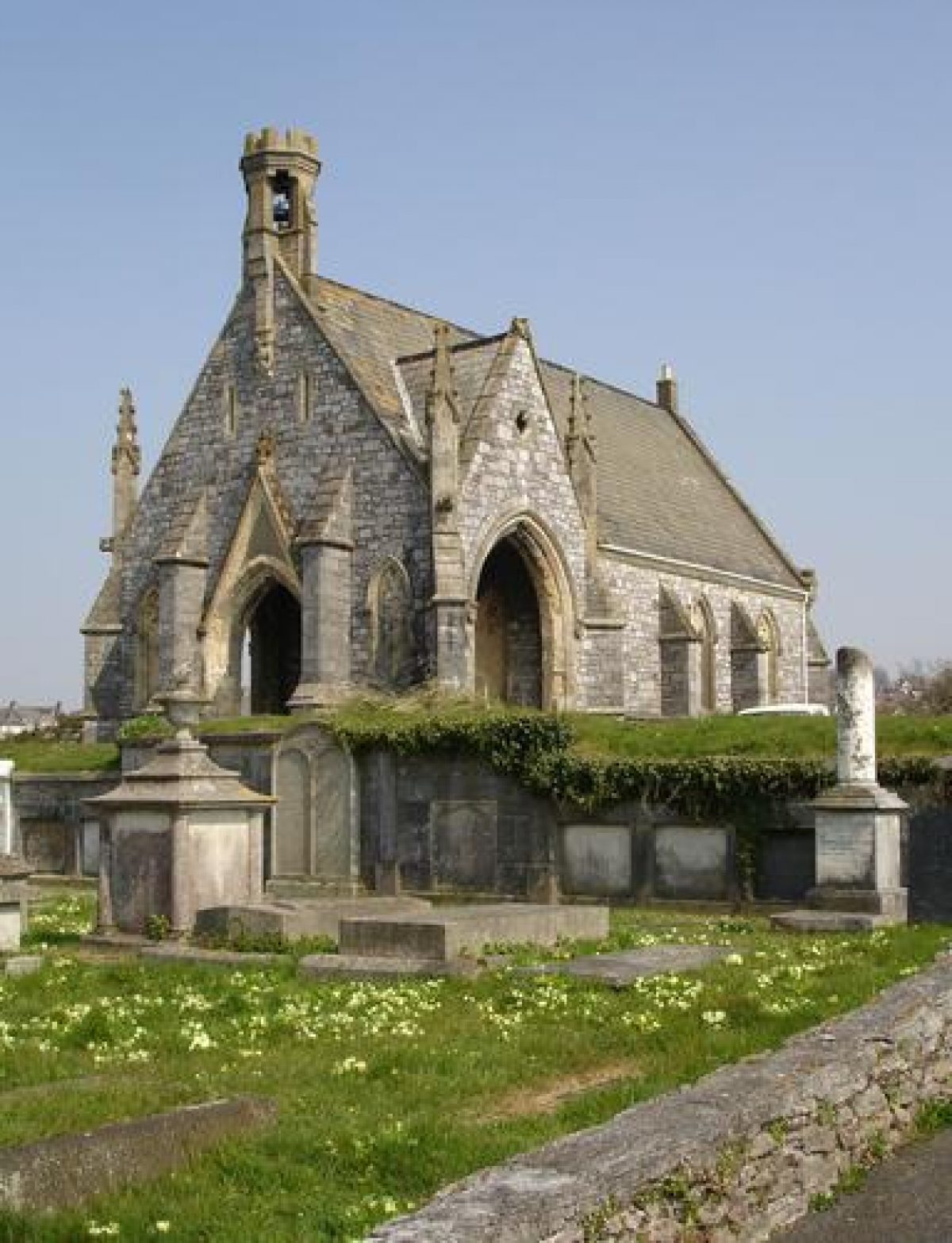
The former Anglican chapel and the mid C20 chapel which replaced the Nonconformist chapel destroyed by enemy action in 1940, stand on an artificially levelled terrace which extends c 150m from south-east to north-west, c 250m north-north-east of the principal entrance. The chapels stand c 50m north and east respectively of the point at which the principal drive joins the terrace, and are separated by burial areas. The former Anglican chapel (listed grade II) stands to the north and comprises a single, hall-like structure, with a gabled porte-cochere set within its western bay. The west gable is surmounted by a low crennellated bell turret, while the gables of the porte-cochere are ornamented with pinnacles and buttresses. The chapel is built in coursed rubble stone with ashlar dressings and gothic windows. Deconsecrated in the 1998, the chapel is today (early C21) used as a store. The mid C20 chapel c 80m south-east of the former Anglican chapel is constructed in a simple gothic style from coursed rubble stone, but lacks the western porte-cochere and associated ornamentation. The chapel, which remains in use in the early C21, is adjoined to the south-east by a single-storey office wing. The nonconformists' chapel replaced by the present structure was of identical design to the surviving former Anglican chapel (photograph, 1889).
Other Land
The principal drive sweeps north, north-east and east-north-east for c 350m, ascending from the principal entrance and lodge to reach the chapel terrace which forms the focal point of Hamilton & Medlands' cemetery scheme. The drive is adjoined to the east and south-east by grass verges and banks planted with a single row of mature beech. The grass verges appear formerly to have incorporated flower beds. To the west and north-west the drive is bordered by a low rubble-stone wall which in part serves to retain the higher ground to the north-west, and also formed the physical division between the consecrated ground to the north and west, and the unconsecrated ground to the south-east, as required by Bishop Phillpotts of Exeter (d 1869) in satisfaction of Canon Law. The first edition OS (c 1860) shows a double row of trees to the south and east of the drive, with a single row to the west. This scheme, which appears to have been part of Hamilton & Medlands' original layout for the cemetery, is also shown on a photograph of 1889; it was subsequently simplified during the C20.
Opposite the lodge, an area of lawns and evergreen shrubs forms the setting for a war memorial in the form of the Cross of Sacrifice. To the north-north-west of the war memorial are the foundations of late C19 glasshouses (OS, 1893) which abutted the stone wall enclosing the Anglican burial areas, a free-standing section of which survives (2003) c 20m north of the war memorial. Some 40m north of the entrance, a grass walk leads west and north from the drive to pass c 200m north-north-west through an avenue of mature Turkey oaks; this feature is shown on the first edition OS (c 1860), and appears to have formed part of Hamilton & Medlands' scheme for the site. The avenue walk allowed access to burial areas at the lower, western end of the consecrated ground, and linked to a walk parallel to the north-western boundary of the mid C19 cemetery, which approximately corresponds to the walk forming the boundary of the registered site.
As the drive ascends towards the chapel terrace, it turns north-east, passing to the south-east of a rectangular garden of remembrance for the interment of cremated remains. This C20 garden is enclosed by rubble-stone walls c 3m high, which are the remains of a picturesquely gabled mid C19 cottage which is shown on the first edition OS (c 1860), and a photograph of 1889.
The chapel terrace is partly enclosed to the south-west by ranges of mid C19 catacombs comprising raised, grass-topped mounds retained to the north-east and south-west by ashlar walls, in which loculi are closed by memorial slabs. Further, similar ranges of catacombs extend to the north-west of the Anglican chapel, and to the north-east of both chapels. These latter catacombs extended parallel to the north-eastern boundary of the mid C19 cemetery. There are further catacombs and vaults set into the south-west facing slope above a secondary drive leading north-west from the principal drive at a point immediately south-west of the former shelter.
From the chapel terrace, a walk extends south-west on axis with the west façade of the Anglican chapel, passing through a break in the range of catacombs, to reach a rond-point c 80m south-west of the chapel, the centre of which is occupied by a set of raised vaults. Circular on plan, with loculi marked by commemorative slabs on the circumference, the central area of the range is covered with lawn surrounding a single sarcophagus. A similar set of raised vaults is situated south-west of the chapel standing on the site of the nonconformist chapel, thus creating a symmetrical plan below the chapel terrace. The raised vaults and the associated walks formed part of Hamilton & Medlands' layout for the cemetery, and are shown on the first edition OS (c 1860), and a photograph of 1889, which also indicates that the raised grass areas were formerly planted with specimen Irish yews.
The burial areas to the north-west and south-east of the principal drive are laid out to a grid pattern divided by subsidiary walks and planted with scattered specimen trees and conifers including significant numbers of Irish yews which may relate to the mid C19 planting scheme (pers comm Dr Will). The path pattern shown on the first edition OS (c1860) with curvilinear walks to the south-west of the circular raised vaults appears to have been simplified in the late C19 (OS, 1893). The area to the south-west of the chapel terrace contains a representative collection of predominantly mid and late C19 monuments.
The area to the north-east of the chapel terrace is similarly laid out to a grid pattern, with scattered specimen trees and conifers, including deodar cedars and a monkey puzzle, being planted in the burial areas. This ground, which formed part of the Company's original acquisition in 1846, was progressively appropriated for burials from c 1870, having been used as grazing land in the interim. It is not included in the site here registered.
REFERENCES
The Builder, 5 (24 April 1874), p 198
B Cherry and N Pevsner, The Buildings of England: Devon (2nd ed 1989), pp 637-8, 648
Ford Park Cemetery Trust, Ford Park Cemetery, introductory booklet (c 2000)
Maps
OS 6" to 1 mile: second edition, published 1894
OS 25" to 1 mile: first edition, c 1860 (no survey or publication date); second edition, revised 1892-3, published 1893
Illustrations
F Frith, photograph of Plymouth Cemetery from the south-west, 1889
Archival items
Minutes and records of the Plymouth, Devonport and Stonehouse Cemetery Company, 1846-50 (private collection)
H A Will, A brief historical note on the landscape at Ford Park Cemetery, 2003
Information from Dr Will and the Ford Park Cemetery Trust
REASONS FOR DESIGNATION
Ford Park Cemetery is designated at Grade II* for the following principal reasons:
* A good example of a mid-19th century garden cemetery (1847-8).
* A substantial example of the work of the noted cemetery designers J R Hamilton and J M Medland.
* The cemetery layout survives intact.
* The cemetery includes burial vaults of an unusual above-ground design.
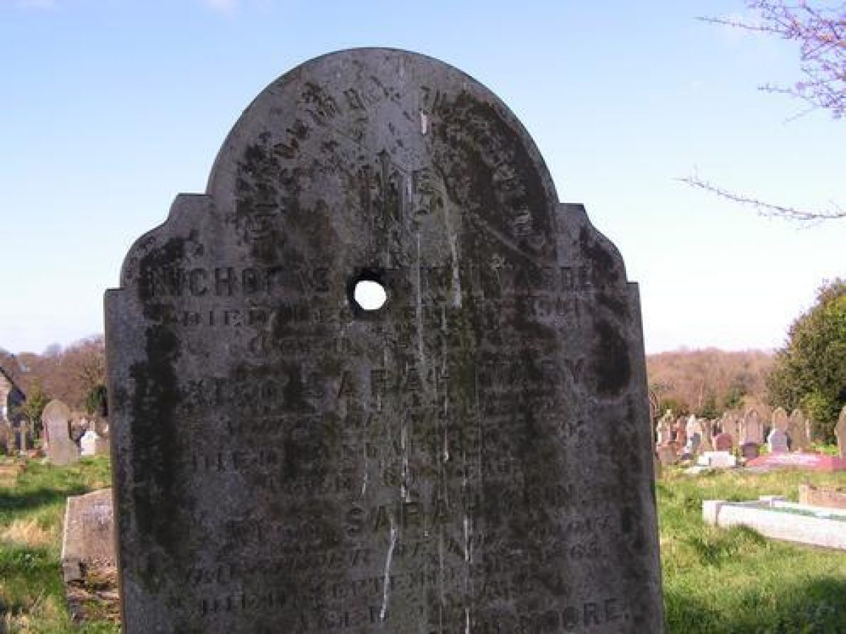
* The cemetery contains a good collection of funerary monuments which reflects the social and economic development of Plymouth and Devonport in the 19th century.
Description written: March 2003
Revised: July 2003
Edited: May 2004
Upgraded: November 2009
- Visitor Access, Directions & Contacts
Telephone
01752 665442Owners
Ford Park Cemetery Trust
- History
The following is from the English Heritage Register of Parks and Gardens of Special Historic Interest.
HISTORIC DEVELOPMENT
During the early C19 the three adjoining towns of Plymouth, Devonport and Stonehouse grew rapidly as the Naval dockyard at Devonport expanded (Pevsner, 1989). The resulting growth in population placed an increasing burden on the towns' existing churchyards, and in 1846 the Plymouth, Devonport and Stonehouse Cemetery Company was established by Act of Parliament and purchased 18 acres (c 7.25 ha) of previously undeveloped land at Ford, to the north of Plymouth, for the formation of a cemetery. Designs for laying out the proposed cemetery were invited, and in April 1847 the premium was awarded to J R Hamilton and J M Medland of Gloucester (Builder, 1847), who designed Warstone Lane Cemetery, Birmingham (1848, qv) and Welford Road Cemetery, Leicester (1848, qv). Hamilton & Medlands' scheme for Ford Park Cemetery was chosen in preference to one submitted by the local architect, George Wightwick (Builder, 1847).
Hamilton & Medlands' design included an entrance lodge, and formal drive ascending to a terrace which formed the setting for two chapels. The area to the south-west of the terrace and chapels, together with a narrow strip of ground to the north-east was laid out for burials in 1847-8, while the remainder of the site purchased in 1846, extending to some c 3.25ha to the north-east of the chapels, was let for grazing and at various times offered for sale in order to improve the company's finances. The cemetery was opened for burials on 1 December 1848. In 1848-9 £23-16-6 was spent on planting trees and shrubs in the cemetery (Minutes), while a further £30-0-0 was spent to plant an avenue extending from Pennycomequick to the principal entrance to the cemetery (Minutes). In its early years the cemetery company suffered from precarious finances, and it appears that Hamilton & Medlands' scheme was modified by members of the company board in order to secure economies (pers comm Dr Will). The cemetery is shown as originally laid out on the first edition OS (c 1860).
The area to the north-east of the chapels was appropriated for burials in the 1860s, while in 1874-5 the company purchased a further area of land to the north-west of their original property. This extension was laid out to a grid pattern and planted in a more simple style; it is not included in the registered site. By the late C19 a separate Jewish burial ground had been established to the north-east of the original cemetery; these areas are not included in the registered site.
During the Second World War, the cemetery suffered bomb damage during air raids on Plymouth and the dockyards. In particular, the nonconformist chapel was destroyed in a raid in 1940. It was re-built on the same site, but to a simpler design in the late 1950s. In the second half of the C20, the company began to face mounting financial difficulties as the number of burials declined (Ford Park Cemetery Trust). It finally went into voluntary liquidation in 1999, and the site was vested in the Ford Park Cemetery Trust, a charity which manages it as a working cemetery. Today (2003), the site remains in divided ownership, with the cemetery lodge in private ownership and the remainder of the registered site in the ownership of Ford Park Cemetery Trust.
Period
- Post Medieval (1540 to 1901)
- Victorian (1837-1901)
- Associated People
- Features & Designations
Designations
The National Heritage List for England: Register of Parks and Gardens
- Reference: 5279
- Grade: II*
The National Heritage List for England: Listed Building
- Reference: Church of England chapel.
- Grade: II
Features
- Chapel (featured building)
- Description: The former Anglican chapel stands to the north and comprises a single, hall-like structure, with a gabled porte-cochere set within its western bay. The west gable is surmounted by a low crennellated bell turret, while the gables of the porte-cochere are ornamented with pinnacles and buttresses. The chapel is built in coursed rubble stone with ashlar dressings and gothic windows.
- Earliest Date:
- Latest Date:
- Chapel
- Description: The original Nonconformist chapel was destroyed by enemy action in 1940. The mid-20th-century replacement some 80m south-east of the former Anglican chapel is constructed in a simple gothic style from coursed rubble stone, but lacks the western porte-cochere and associated ornamentation.
- Earliest Date:
- Boundary Wall
- Description: The site is enclosed to the south-east and south-west by stone walls of varying heights.
- Earliest Date:
- Religious, Ritual And Funerary Features
- Description: A range of mid-19th-century catacombs extending from south-east to north-west.
- Earliest Date:
- Latest Date:
- Walk
- Description: The north-western boundary of the registered site is formed by a straight walk extending from south-west to north-east through the floor of a valley.
- Water Course
- Description: The walk follows the course of a 16th or 17th-century leat, now culverted, which runs through the valley.
- Entrance
- Description: The principal entrance comprises a pair of 20th-centrury wrought-iron carriage gates supported by a pair of stone piers surmounted by gabled caps, which are flanked by low stone quadrant walls supporting 19th-century cast-iron railings.
- Gate Lodge
- Description: Within the cemetery, and immediately east of the entrance, stands a picturesque, single-storey gothic lodge.
- Avenue
- Description: In the mid-19th century an avenue of limes was planted by the cemetery company along Central Park Avenue.
- Earliest Date:
- Latest Date:
- Entrance
- Description: There is a further vehicular entrance to the cemetery. A pair of tall stone piers with gabled caps supports a pair of 20th-century wrought-iron carriage gates.
- Drive
- Description: The principal drive sweeps north, north-east and east-north-east for some 350m, ascending from the principal entrance and lodge to reach the chapel terrace.
- Lawn
- War Memorial
- Description: War memorial in the form of the Cross of Sacrifice.
- Glasshouse
- Description: Foundations of late-19th-century glasshouses.
- Avenue
- Description: An avenue of mature Turkey oaks.
- Earliest Date:
- Latest Date:
- Planting
- Description: Garden of remembrance for the interment of cremated remains.
- Earliest Date:
- Latest Date:
- Terrace
- Description: The chapel terrace.
- Specimen Tree
- Description: Scattered specimen trees and conifers.
- Cemetery
- Key Information
Type
Funerary Site
Purpose
Sacred / Ritual / Funerary
Principal Building
Religious Ritual And Funerary
Period
Post Medieval (1540 to 1901)
Survival
Extant
Hectares
14
Open to the public
Yes
- References
References
- {English Heritage Register of Parks and Gardens of Special Historic Interest} (Swindon: English Heritage 2008) [on CD-ROM] Historic England Register of Parks and Gardens of Special Historic Interest
- Pevsner, N {The Buildings of England: Devon} (Harmondsworth: Penguin, 1952) The Buildings of England: Devon