Introduction
Flaybrick Memorial Gardens was originally Flaybrick Cemetery, a municipal cemetery designed by Edward Kemp in 1864. The cemetery was laid out in the Victorian landscape style, with specimen trees, holly and yew lined paths. An extension added in the 1890s is not part of Kemp's design and is much more open. The site is now a memorial garden and being developed as an arboretum.
Terrain
Slopingwww.historicengland.org.uk/listing/the-list
A public cemetery opened in 1864 and extended in the late C19 and early C20. The layout was designed by Edward Kemp and the buildings by Lucy & Littler.
DESCRIPTION
LOCATION, AREA, BOUNDARIES, LANDFORM, SETTING
The cemetery is situated c 3.2km west-north-west of Birkenhead town centre and c 0.4km north-west of Birkenhead Park. The irregular c 10.5ha site occupies rising ground below Bidston Hill to the north-west and above the River Mersey to the east.
The southern area of the site is bounded by Tollemache Road to the east, Upper Flaybrick Road to the south, and Boundary Road to the west. These boundaries are marked by c 1m high stone walls with c 1.5m high piers with roll-top detail. The walls are stepped at pier positions to follow the ground contour. The lower sections of wall are generally topped with c 0.4m high C20 railings with infilled sockets indicating that these are replacements. Extended stone piers mark the boundary at the junctions of Upper Flaybrick Road with Tollemache Road and Boundary Road. The north boundary of the southern section of the gardens, within the former quarry area, is marked by a c 3m high stone wall with raking coping. Stone for the boundary walls came from adjoining Flaybrick Quarry (Wirral MBC guide leaflet).
The north-west, Roman Catholic, area is bounded by housing to the west and east and by Lower Flaybrick Road (formerly part of New Road) to the north. The east boundary is marked by c 4m high C20 timber fencing and other boundaries by C20 stone walls and railings.
The site slopes generally up to the south and west with views out from the higher ground to Liverpool, across the River Mersey to the east. To the west of the site lie allotments, an urban farm, and the rising slopes of Taylor's Wood and Bidston Hill. The surrounding areas to the north, west, and south are generally residential. Immediately to the north, the site of a C19 isolation hospital has been developed in the late C20 for housing with a small wooded area retained at the south-west corner adjoining the cemetery.
ENTRANCES AND APPROACHES
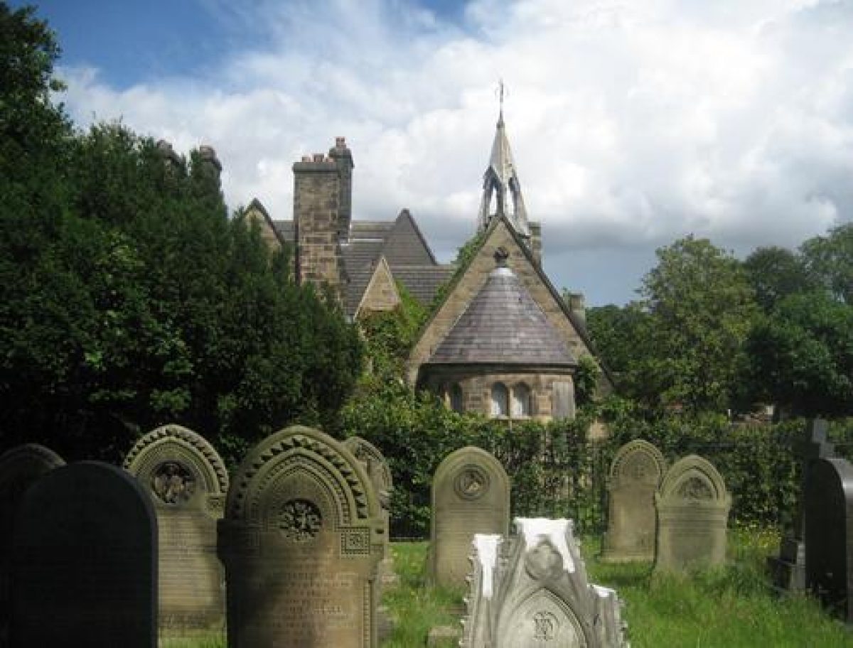
All main entrances and entrance buildings were designed by Liverpool architects Lucy & Littler and constructed in 1862-64. The principal entrance (listed grade II) lies on the east boundary and is aligned on the main east/west axis with Bidston Avenue. It comprises a carriage entrance flanked by two pedestrian entrances, all with C19 cast-iron gates set back from the road between polygonal stone gate piers and quadrant flanking stone walls. The south pier to the carriage entrance is inscribed 'B.I.C.' (Birkenhead Improvement Commissioners) and the north pier with the date 1864. A niche in the south flanking wall marks the position of a former drinking fountain. Immediately north-west of the entrance stands the stone Cemetery Office and Lodge (listed grade II), a one- and two-storey building in Gothic style with a 'fanciful bell-turret' (Pevsner and Hubbard 1971). A second entrance (listed grade II), which terminates the main east/west axis on the west boundary, is in similar style to the principal entrance but without a lodge.
The north-west, Roman Catholic, area is served by two further entrances. The first (listed grade II) is set on a short right-angled return in the boundary to Boundary Road, c 160m north-north-west of the chapels; it is in similar style to the principal entrance. Immediately to the north-west of this entrance to the Roman Catholic area is a small stone lodge (listed grade II), similar in style to the Office and Lodge at the principal entrance. The second entrance (listed grade II) to the Roman Catholic area is situated on the north boundary, c 410m north-north-west of the principal entrance. It is marked by a carriage entrance below a corbelled, stilted stone arch with stepped gable and a pedestrian gate to the east below a lower arch and gable, both now (2001) without gates and with the carriage entrance infilled with a c 2m high stone wall. Between the two gateways a niche with triangular hood mould over and granite basin below marks the position of a former drinking fountain.
Some 70m and 120m north-north-east of the principal entrance on Tollemache Road there are vehicle entrances into the yard adjoining the Rangers' Office and into the lower former quarry area respectively, both with pairs of C20 metal gates.
PRINCIPAL BUILDINGS
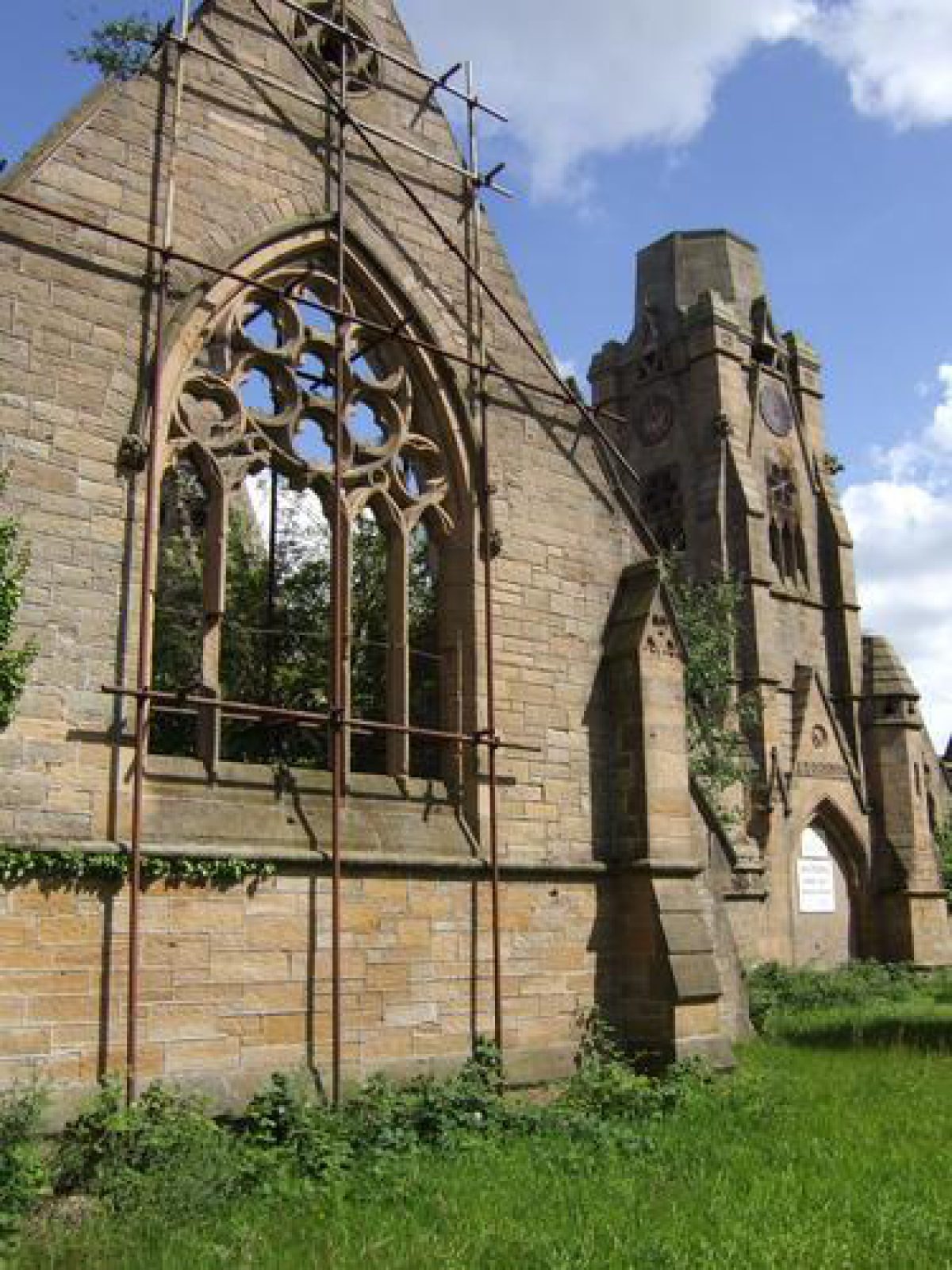
Some 150m west of the principal entrance the Anglican and Nonconformist mortuary chapels of 1862-64 by Lucy & Littler (listed grade II), to north and south respectively, are sited on a terrace with low stone retaining walls to the east, at the west end of the main axis path. From here there is a long view out along the axis to the east to Liverpool city centre on the opposite bank of the River Mersey. The stone chapels are symmetrical, flanking a central cloister range with a tower set on the main east/west axis with the principal entrance and Bidston Avenue beyond. The main part of the spire above the tower has been removed. The chapels are now (2001) derelict and enclosed within a security fence. A granite First World War memorial cross is situated adjacent to the east elevation of the tower.
OTHER LAND
In the southern area of the cemetery the Anglican and Nonconformist chapels are set axially with the principal entrance and main drive, on a terrace which is level with the Boundary Road entrance. The lower ground, to the east of the chapels, lies between low east/west embankments sited c 60m to the north and south of the main drive. The north-east area occupies the lower ground of the former quarry site. To the south of this area a 3-4m high vertical stone face runs east/west, above an irregular embanked terrace which returns north and diminishes to the west of the former quarry.
The irregularly shaped grounds comprise three contrasting areas. The main southern (Anglican and Nonconformist) area is laid out with a formal design, set symmetrically about an east/west axis. This is in contrast to the generally less formal layout of the smaller, Roman Catholic area to the north-west. Both of these areas were laid out in 1862-64 (1864 plan) to Kemp's design. In the third area, to the north-east, the formal layout is extended but is set against the irregular topography of the former quarry.
From the principal entrance the main axial drive rises gently, leading west for c 125m before dividing to encircle the Anglican and Nonconformist chapels, rejoining adjacent to the southernmost entrance from Boundary Road. To the north-east and south-east of the chapel terrace the drive is embanked and enclosed by low stone walls.
Some 70m to both north and south of the main drive, a low embankment runs parallel, each embankment separating a pair of axial paths, with the outer of each pair at a higher level. These outer paths are linked to the main drive by cross-axial paths with stone steps at the embankments. Elsewhere changes of level are achieved by paths being ramped within stone balustrades. Junctions of cross-paths with the outer east/west paths are generally marked by a widening of the path to form a circular feature, some with a central tree. The main drive and outer axial paths are lined with clipped hollies which reinforce the symmetrical design and contrast with informal groups and specimen trees which include cut-leaf beech, silver pendant lime, and araucaria. The overall layout and formal planting are as indicated on the 1864 plan of the cemetery.
The formal layout is continued with grassed paths into the southern area adjoining Upper Flaybrick Road. The ground level drops by c 3-4m c 110m north of the main drive, on the irregular east/west line of the vertical cliff-like stone face of the former quarry. Some 30m north of the stone face a c 2m embankment runs east/west forming a terrace above the lower former quarry area to the north. The central formal path layout is continued in this north-east area of the site with similar features of circular path junctions, stone steps, and stone balustrades to ramped sections of paths.
From the lodge adjacent to Boundary Road a path leads north, on a serpentine route, to the site of the former Roman Catholic mortuary chapel. This lay c 200m north-north-east of the Roman Catholic lodge and is marked by a grassed area and a Memorial Wall. From the former chapel site a path curves east and then north to the entrance on the north boundary. A second path leads east from the Roman Catholic lodge for c 50m to a junction before curving south to form the cross path leading to the Anglican chapel. Some 100m east-south-east of the Roman Catholic lodge, a ramped link leads off this path to the former quarry area. The area to the west of the Roman Catholic area is generally grassed with no apparent remains of the formal path layout to the west of the chapel shown on the 1864 plan. Both north and west boundaries of this section are planted with belts of mature trees with informal groups of trees within the site.
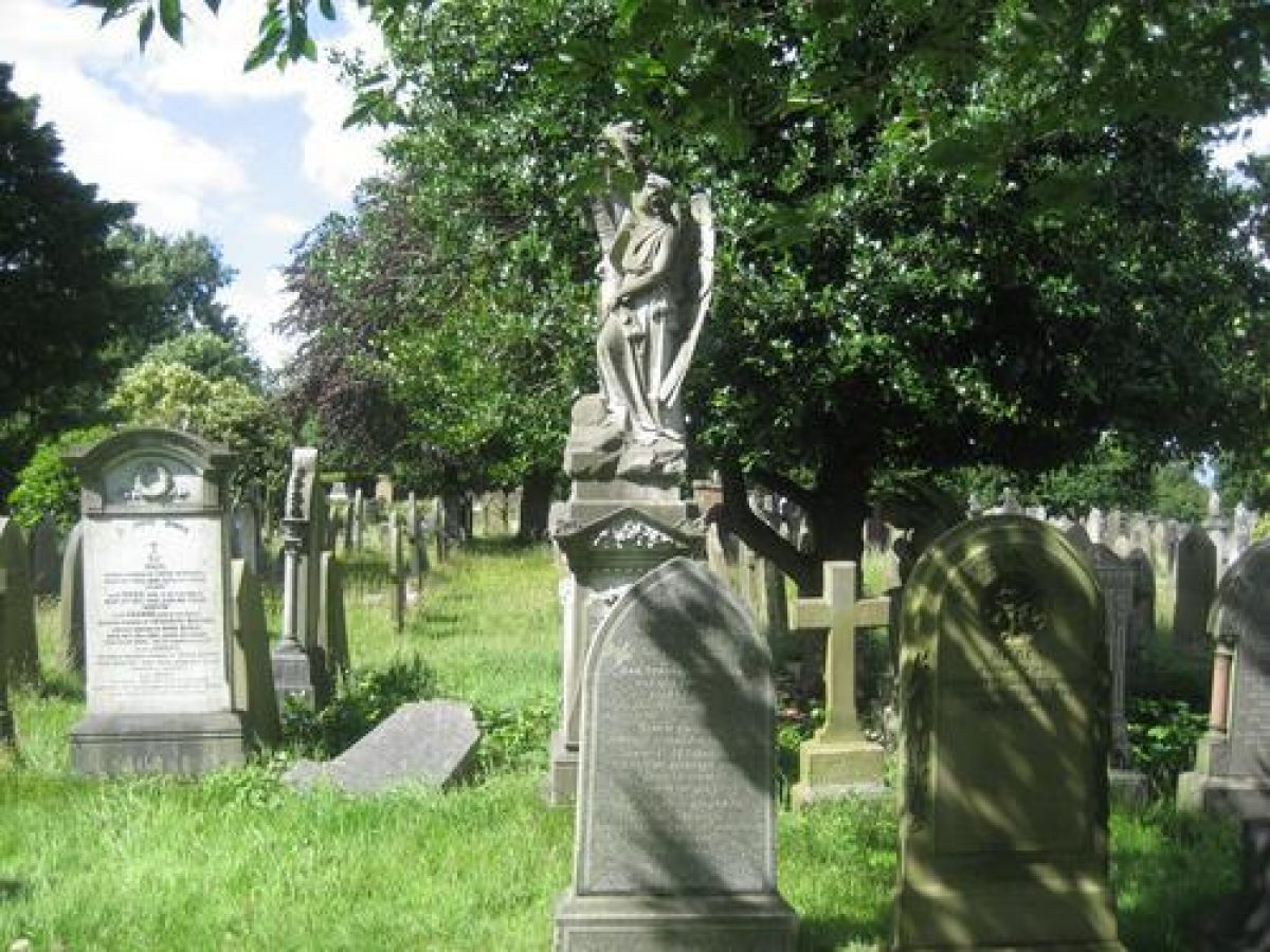
The cemetery contains a number of graves of architectural and historical interest. These include the family vault of the Laird family, of shipbuilding fame, and at a path junction, 120m north-west of the principal entrance, the imposing canopied stone tomb of Sir William Jackson who was instrumental in the creation of Birkenhead Park. The cemetery's designers, Edward Kemp, Charles Lucy, and Charles Littler are also all buried here.
REFERENCES
Sanderson, Sanderson's Hand-Book to the Birkenhead Cemetery, Flaybrick Hill (1871) [copy in Birkenhead Central Library]
N Pevsner and E Hubbard, The Buildings of England: Cheshire (1971), p 95
Flaybrick Memorial Gardens, leaflet, (Friends of Flaybrick and Wirral MBC c 1980)
Birkenhead (Flaybrick Hill) Cemetery, Draft Development Plan (Wirral MBC c 1990)
Flaybrick Memorial Gardens, Trail No 1 Monuments, Memorials & Incumbents, leaflet, (Friends of Flaybrick Memorial Gardens 1996)
English Heritage Register Review: Merseyside (1996)
Flaybrick Memorial Gardens, guide leaflet, (Wirral MBC c 2000)
Flaybrick Memorial Gardens (2001) at www.wirral.gov.uk
Maps
Birkenhead Cemetery, Flaybrick Hill, 28 June 1864 (Town Surveyor's Office)
OS 25" to 1 mile: 1st edition published c 1876; 2nd edition published 1899; 3rd edition published 1912; 1927 edition; 1937 edition
Archival items
C19 photographs of chapels held at Birkenhead Central Library
REASONS FOR DESIGNATION
Flaybrick Memorial Gardens are designated at Grade II* for the following principal reasons:
* A complex example of a High Victorian (1862-64) public cemetery for a provincial town.
* The layout was designed by a prolific and renowned designer, Edward Kemp.
* Kemp's extensive and creative layout makes dramatic use of the elevated hillside site overlooking Birkenhead, the Mersey and Liverpool.
* It contains a notable ensemble of buildings including two conjoined chapels, four gateways and lodges and boundary wall, all by eminent Liverpool cemetery architects Lucy & Littler.
* Its local and national social interest is expressed in an artistically rich variety of 19th / early 20th century monuments including many to Liverpool worthies.
* The cemetery layout and its structures survive intact despite the dereliction of the original chapels.
Description written: September 2001
Amended: October 2001
Edited: April 2002
Upgraded: November 2009
- Visitor Access, Directions & Contacts
Access contact details
The site is open daily until 6pm.
Directions
Close to the M53 junction 1
- History
Flaybrick Memorial Gardens was originally known as Flaybrick Cemetery. The cemetery was planned in the 1840s. Joseph Paxton was approached to do the design but the plans were put on hold. By the 1860s the cemetery once more became a priority. A competition was held and Edward Kemp won. Kemp was working at the local Birkenhead Park at the time.
The site chosen was Flaybrick Hill and consisted of 16.5 acres (6.6 hectares). The cemetery was opened on the 30th May 1864. During the 1890s the site was extended to 26 acres (10.4 hectares).
The following is from the Register of Parks and Gardens of Special Historic Interest. For the most up-to-date Register entry, please visit the The National Heritage List for England (NHLE):
www.historicengland.org.uk/listing/the-list
HISTORIC DEVELOPMENT
The Birkenhead Improvement Commissioners were granted powers to establish a cemetery by order of Parliament in 1843. Joseph Paxton (1803-65) was approached for a design (Wirral MBC leaflet) but a recession and subsequent decrease in the population of Birkenhead resulted in no action being taken. With the return of prosperity in the 1860s the proposal was revived and a competition held for the design of a cemetery on a c 6.7ha site adjacent to a sandstone quarry at Flaybrick Hill.
The competition was won by Edward Kemp (1817-91) who was assisted by the surveyor Edward Mills of Birkenhead (ibid). The buildings were designed by Liverpool architects Lucy & Littler and comprised three mortuary chapels, a Registrar's office, and a Sexton's lodge (Pevsner and Hubbard 1971). The cemetery at Flaybrick was the first municipal public cemetery on the Wirral.
Kemp was responsible for the laying out of Birkenhead Park (qv) to designs by Joseph Paxton, was appointed superintendent there in 1845 and, in 1847 also set up in private practice. In addition to designs for a number of public parks in the north-west of England, Kemp also designed the layout of the City of Liverpool Cemetery at Anfield (qv), opened in 1863.
Work on the Birkenhead cemetery commenced in 1862. The general contractor was William Rimmer of Bidston Hall, and John Middlehurst of St Helens was the contractor for the buildings. Kemp's formal layout for the southern area of the cemetery set the linked Anglican and Nonconformist chapels, together with their main approach and two entrances, on an east/west axis aligned with Bidston Avenue (formerly Bailey Street) leading up from Birkenhead town centre to the east (1864 plan). In the north-west area of the site, the Roman Catholic chapel was set within a formal path layout (1864 plan). Some 2ha was allocated for Anglican burials, c 2.4ha for Nonconformists, and c 2.2ha for Roman Catholics (Sanderson 1871). The cemetery, at first named Birkenhead Cemetery, and from c1956 known as Flaybrick Hill, was opened on 30 May 1864. In 1871 it was noted that a rugged and barren piece of land had been turned into 'a place of surpassing beauty and elegance' (ibid).
To the north-east of the 1864 cemetery, the Birkenhead Improvement Commissioners had acquired c 1.7ha of land together with the adjoining Flaybrick Quarry of c 5.3ha for future expansion (ibid). The cemetery was extended into these areas in the late C19 and early C20 (OS 1899, 1912, 1927) although only a part of the former quarry site was utilised.
The Roman Catholic chapel was demolished in 1971 and a Memorial Wall erected on the site. The Anglican and Nonconformist chapels were last used in 1975. The Registrar's office and Sexton's lodge are now (2001) in private ownership. In 1994 the cemetery was renamed Flaybrick Memorial Gardens, although occasional interments continue in existing grave plots.
Flaybrick Memorial Gardens remain (2001) in the ownership of Wirral Metropolitan Borough Council.
Period
- Post Medieval (1540 to 1901)
- Victorian (1837-1901)
- Associated People
- Features & Designations
Designations
The National Heritage List for England: Register of Parks and Gardens
- Reference: GD5005
- Grade: II*
Plant Environment
- Plant Type
- Arboretum
Features
- Specimen Tree
- Walk
- Sculpture
- Chapel (featured building)
- Description: The Anglican and Nonconformist chapels, created by by Lucy & Littler, are sited on a terrace with low stone retaining walls to the east, at the west end of the main axis path. The chapels are now (2001) derelict and enclosed within a security fence.
- Earliest Date:
- Latest Date:
- Boundary Wall
- Description: High stone walls of about 1 metre with roughly 1.5-metre-high piers with roll-top detail.
- Railings
- Description: The lower sections of wall are generally topped with approximately 0.4-metre-high 20th-century railings.
- Earliest Date:
- Latest Date:
- War Memorial
- Description: A granite First World War memorial cross is situated adjacent to the east elevation of the tower.
- Entrance
- Description: The principal entrance lies on the east boundary and is aligned on the main east/west axis with Bidston Avenue. It comprises a carriage entrance flanked by two pedestrian entrances, all with C19 cast-iron gates set back from the road between polygonal stone gate piers and quadrant flanking stone walls.
- Earliest Date:
- Latest Date:
- Gate Lodge
- Description: Immediately north-west of the entrance stands the stone Cemetery Office and Lodge, a one- and two-storey building in Gothic style with a 'fanciful bell-turret'.
- Earliest Date:
- Latest Date:
- Entrance
- Description: A second entrance, which terminates the main east/west axis on the west boundary, is in similar style to the principal entrance but without a lodge.
- Earliest Date:
- Latest Date:
- Entrance
- Description: One entrance to the Roman Catholic area is in similar style to the principal entrance.
- Earliest Date:
- Latest Date:
- Gate Lodge
- Description: Immediately to the north-west of the first entrance to the Roman Catholic area is a small stone lodge, similar in style to the Office and Lodge at the principal entrance.
- Entrance
- Description: The second entrance to the Roman Catholic area is situated on the north boundary, c 410m north-north-west of the principal entrance.
- Embankment
- Description: The lower ground, to the east of the chapels, lies between low east/west embankments sited c 60m to the north and south of the main drive.
- Drive
- Description: From the principal entrance the main axial drive rises gently, leading west for c 125m before dividing to encircle the Anglican and Nonconformist chapels.
- Balustrade
- Description: Changes of level are achieved by paths being ramped within stone balustrades.
- Chapel
- Description: The site of the former Roman Catholic mortuary chapel. This lay c 200m north-north-east of the Roman Catholic lodge and is marked by a grassed area and a Memorial Wall.
- Tree Belt
- Description: Belts of mature trees.
- Tomb
- Description: The family vault of the Laird family, of shipbuilding fame.
- Tomb
- Description: 120m north-west of the principal entrance is the imposing canopied stone tomb of Sir William Jackson who was instrumental in the creation of Birkenhead Park.
- Tomb
- Description: The cemetery's designers, Edward Kemp, Charles Lucy, and Charles Littler are also all buried here.
- Key Information
Type
Funerary Site
Purpose
Commemorative
Plant Environment
Plant Type
Principal Building
Religious Ritual And Funerary
Period
Post Medieval (1540 to 1901)
Survival
Extant
Hectares
10.5
Open to the public
Yes
Electoral Ward
Birkenhead and Tranmere
- References
References
- {English Heritage Register of Parks and Gardens of Special Historic Interest}, (Swindon: English Heritage, 2008) [on CD-ROM] Historic England Register of Parks and Gardens of Special Historic Interest
- Pevsner, N. and E. Hubbard, {The Buildings of England: Cheshire} (Harmondsworth: Penguin, 1971), p. 95 The Buildings of England: Cheshire
- Donald Insall Associates {Flaybrick Cemetery Conservation Area Appraisal and Management Plan} (2007) Flaybrick Cemetery Conservation Area Appraisal and Management Plan