Introduction
Ebberston Hall has the remains of geometrical pleasure grounds and water gardens. The site is open by appointment only. Contact 01723 859057 for further details.
Terrain
The site is on undulating land encompassing two narrow valleys.The following is from the Register of Parks and Gardens of Special Historic Interest. For the most up-to-date Register entry, please visit The National Heritage List for England (NHLE):
Gardens with water features of around 1718 which were integral to the design of Ebberston Hall and views of the wider landscape from it, and a park with origins of the same or earlier date which was enlarged probably in the early 19th century.
Location, Area, Boundaries, Landform and Setting
Ebberston Hall lies immediately north and west of the village of Ebberston in a rural and agricultural setting. The c 21 ha site is on undulating land encompassing two narrow valleys called Kirk Dale, also known as Cherry Garth Slack, and Beech Slack which run approximately parallel to one another from north to south across the site. The east side of the site is bounded by Scamridge Lane and the west side by Hagg Side Lane. The A170 forms the south-west boundary, and fences divide the north and south-east boundaries from agricultural land.
Entrances and Approaches
The principal entrance is from the south where a drive runs north-east from the A170 passing the west side of the church and continuing to the south side of the Hall. Another entrance, also from the A170, lay c 320 m to the east of this entrance and this survives as a grass track flanked by some horse chestnut and lime trees. An avenue shown running south-east from the Hall on a map of 1770 could be on the line of the northern part of this approach. Other entrances to the site are from tracks and footpaths. The 1770 map shows an entrance with gates and gate piers due south of the Hall on the main road, which ran on a line north of its present course at that time.
Principal Building
Ebberston Hall (listed grade I) was designed by Colen Campbell in 1718 for William Thompson. The Hall is illustrated in Vitruvius Britannicus (1725), and the building is in the scale and form of a summer retreat rather than a country house. It was probably conceived as a hunting lodge which made reference to Italian or even Roman countryside summer villas. The north elevation has a three-bay loggia with Tuscan columns on the first floor from which the gardens to the north can be viewed, though the openings were later glazed, possibly during the C19. The building was flanked by pavilions, linked to it by curving walls, of which that to the east has been demolished, though part of the linking wall survives. The western pavilion has been rebuilt. The Hall lies at the mouth of the narrow valley called Kirk Dale where it was sited to take advantage of the narrowing views up the valley to the north and contrasting wide views over the Wolds to the south. The building was probably modified in the early C19 and the ground floor was extended to the east c 1935. It is in use as a private residence (1998).
St Mary's church (listed grade II*) lies c 120 m south-west of the Hall within a churchyard. The building has Norman origins and was restored by Ewan Christian in 1876.
Gardens and Pleasure Grounds
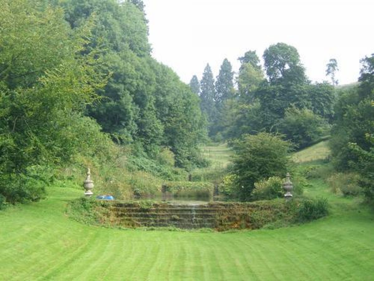
The Hall overlooks a lawn on the north side, and c 45 m to the north of this water from a canal flows over a stepped cascade (listed grade II*) which has stone urns on each side of it. The canal widens at its north end and a second stepped cascade (listed grade II*) carries water from an upper canal which is fed from springs which rise from the limestone and are channelled into a pool c 120 m north of the Hall. Water runs from the pool over a rubble wall into the top canal. There are views northwards from the Hall up the steep-sided valley, which is thickly planted with trees on the west side, and less densely planted on the east side. The planting includes a number of Wellingtonias (planted c 1900) and the trees frame the views of the cascades. A path leads along the east side of the canals and there are views from it southwards down the valley in which the Hall is framed against the sky and appears to rise directly from the canal. The water runs beneath the lawn to the west of the Hall before running south through the park.
A description written by Colen Campbell (published 1725) states that the canal was '1200 feet long and runs under the Loggia on the back Front' but since the present extent is c 80 m, and the total distance between the north front of the Hall and the top of the system only c 140 m, it is difficult to account for the 365 m which Campbell mentions, unless this included water features to the south of the Hall. The 1770 map shows the canals and a third stretch of water immediately north of the Hall where the north lawn is situated. This is shown on paintings of c 1745 attributed to John Settrington (Harris 1979). His views of the north side of the Hall also show an island with a pyramid surmounted by a statue of Mercury. The canal sides are shown flanked by clipped bushes and paths lined with flowers and flowering shrubs running alongside the thickly planted valley sides. A bridge shown to the north of the canals also appears on the 1770 map.
The paintings offer an exaggerated view of the size of the stretches of water and it is possible that other features are exaggerated, idealised or represent proposals rather than what was actually there. An account of 1798 (quoted in Hepworth 1995) states that the water was routed around the Hall by an aqueduct. It is possible that there were problems of drainage or water penetration into the Hall which necessitated modification of the system.
On the south side of the Hall steps lead down from a central entrance to a lawn from which long views over the Vale of Pickering can be obtained. A fence separates the lawn from the park. One of the paintings by Settrington shows the south side of the Hall with a system of canals and fountains in front of it. There is no sign of these on the 1770 map and it is not known whether they ever existed; a walled enclosure shown on the map however does appear to correspond with an orchard shown in the painting's right-hand foreground, while the walled enclosure on the left-hand side could be the churchyard walls.
The designer of the water features is not known but Stephen Switzer (1682-1745) is suggested by several sources (see for example Hussey 1967), while William Benson, successor to Wren as Surveyor-General during Thompson's tenure as Master of the Mint, is also a plausible candidate as he was in direct contact with Campbell, who was his deputy, and he had experience of designing fountains (see Hepworth 1995). That the designs of the garden and Hall were closely related is implicit in the careful positioning of the building, while the relationship of the Hall and gardens with the wider landscape is consistent with Switzer's ideas, published in 1715 (as the first volume of Ichonographia Rustica), concerning the importance of views of the countryside unobstructed by high walls or enclosing plantations.
Park
Open grassland with scattered trees lies on the south side of the Hall and around St Mary's church. The area east of the church was the site of several buildings shown on the mid C17 map when the road ran north of its present line along the south side of the churchyard. A row of buildings is also shown on the south side of the road. The 1770 map shows that the buildings east of the church had disappeared apart from one house to the east of the orchard shown in Settrington's painting, while there were still buildings along the south side of the road. The road is shown on its present line on the 1854 OS map by which time all the buildings apart from the church had been cleared.
Woodland called Hagg Side Plantation shelters the west side of the site, along the side of Kirk Dale. On the east side of the Hall there is woodland with a number of yew trees called The Rookery. The pattern of planting has similarities with what is shown on the 1770 map which shows The Rookery extending north of its present line and converging rows of planting on each side of the valley. Campbell's description of Ebberston states that 'This small rustick Edifice stands in a fine Park well planted...' suggesting that Thompson may have begun the park planting before the Hall was built.
The 1854 OS map shows that there were belts of trees along the northern and eastern park boundaries and woodland south of St Mary's church.
Maps [reproduced in Hepworth 1995]
- The Manor of Ebberston, no date (probably mid-17th century)
- Ebberston Enclosure Map, 1770
- OS Maps
- OS 6" to 1 mile: 1st edition published 1854
- OS 25" to1 mile: 2nd edition published 1911
Archival items
- Estate Sale Catalogue (extract), 27 June 1941 [reproduced in Hepworth 1995]
- Additional information from V J Hepworth
Description written: November 1998
Amended: March 1999
Edited: October 1999
- Visitor Access, Directions & Contacts
- History
The following is from the Register of Parks and Gardens of Special Historic Interest. For the most up-to-date Register entry, please visit The National Heritage List for England (NHLE):
16th and 17th Centuries
Ebberston was owned by the St Quintins prior to 1566 when it passed to the Etherington family. The earls of Danby had acquired it by the 17th century and it was sold to William Thompson in 1674.
18th to 20th Century
Thompson's grandson, also William, who served as Master of the Mint 1718-25, built the Hall and laid out the grounds. In 1744 the property passed to his cousin William, whose son Lilingstone Thompson died childless and intestate in 1771. The estate passed to Sir Charles Hotham, eighth baronet, and eventually to the third Lord Hotham, who sold it in about 1814 to George Osbaldeston. The property was sold again in 1845 to the Cayley family who disposed of it in 1941. It is in private ownership (1998).
- Associated People
- Features & Designations
Designations
The National Heritage List for England: Register of Parks and Gardens
- Reference: GD2064
- Grade: II*
Style
Geometric
Features
- Hall (featured building)
- Description: The hall was built in 1718 by William Thompson, MP for Scarborough and Master of the Mint. It is a small Palladian mansion.
- Earliest Date:
- Latest Date:
- Water Feature
- Description: Parts of the water garden remain.
- Earliest Date:
- Latest Date:
- Key Information
Type
Garden
Purpose
Ornamental
Survival
Part: standing remains
Hectares
51
Civil Parish
Ebberston and
- References
References
- {English Heritage Register of Parks and Gardens of Special Historic Interest}, (Swindon: English Heritage, 2008) [on CD-ROM] Historic England Register of Parks and Gardens of Special Historic Interest
- Harris, J., {The Artist and the Country House} (London: Russell Chambers, 1979), pp. 190-1 The Artist and the Country House
- Pevsner, N., {The Buildings of England: Yorkshire The North Riding} (Harmondsworth: Penguin, 1966), p. 154 The Buildings of England: Yorkshire The North Riding
- pp 4-5, 47 Vitruvius Britannicus. 3
- Country Life, 116 (7 October 1954), pp 1158-61; (14 October 1954), pp 1254-7 Country Life, 116
- pp 65-9 English gardens and landscapes 1700-1750
- Ebberston Hall, Scarborough, North Yorkshire
Contributors
Val Hepworth