Introduction
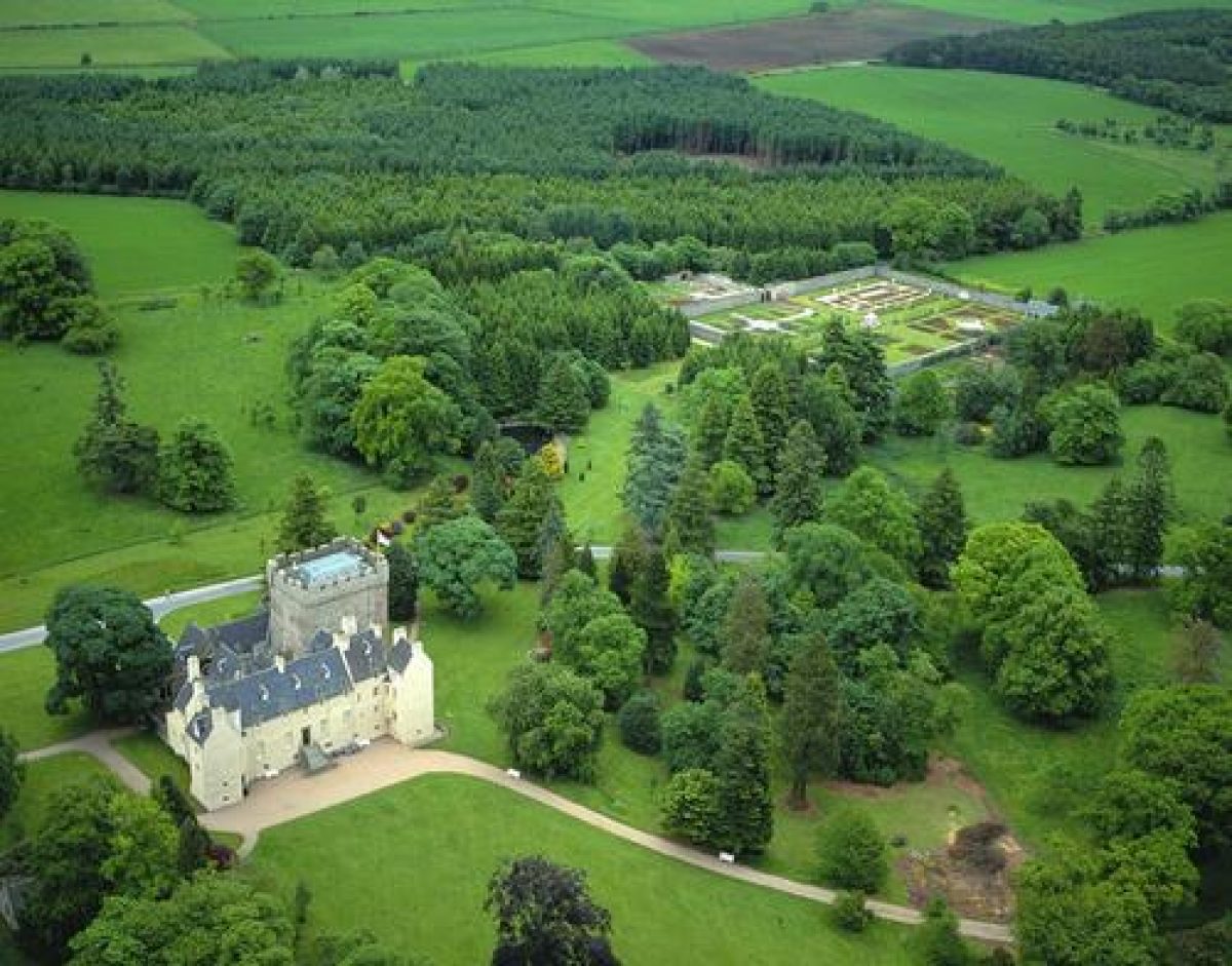
The original designed landscape of Drum Castle was established at the end of the 18th century and incorporated the church and the Old Forest of Drum. Most of the extant parkland layout and planting dates from the 19th century, although some original trees remain on the drive. There is a late-19th-century arboretum with interesting conifers, a small 20th-century water garden and a restored walled garden.
http://portal.historic-scotland.gov.uk/hes/web/f?p=PORTAL:DESIGNATIONS:0
Type of Site
No information available.
Location and Setting
Drum Castle is situated on a ridge to the north of the valley of the River Dee approximately 2 miles (3km) to the west of Peterculter and some 10 miles (16km) west of Aberdeen. The A93 lies to the south, beyond the farm, and minor roads enclose the policies to the north, west and east. The Hill of Fare 1,320' (433m) lies to the west, the foothills of which provide the setting for Drum Castle. The surrounding land is used largely for agriculture and forestry. There are glimpses of the hills to the north from the area around the Castle through the park trees whilst magnificent panoramic views are gained from the top of the Castle tower. The canopy of the enclosing woodland contributes to the surrounding scenery but there are few views into the policies from the surrounding roads.
Drum Castle is situated today amid some 393 acres (159ha) of policies. They extend north and west to the edge of the Old Forest of Drum, south to the access road to the Home Farm, and east to the lodge on the A93. Documentary evidence, provided by Roy's map of c.1750, the 1st edition OS of c.1860 and the 2nd edition OS of c.1900 indicates that the designed landscape was extended in the latter half of the 18th century. An avenue once ran through Robbie Rossie's Wood and Avenue Plantation from the Castle to the East Lodge, a distance of approximately 1 mile (2km). Robbie Rossie's Loch is incorporated within Robbie Rossie's Wood which lies to the north of this old east drive. The designed landscape to the east of the minor road between the A93 and Milton of Drum to the north is considered by the National Trust for Scotland to be outwith the policies today, since this area is beyond their ownership boundary. It is, nonetheless, still a significant part of the overall designed landscape.
Landscape Components
Architectural Features
Drum Castle, listed category A, was built around a tower dated 1280-1300. The Jacobean Wing was added in 1619 and alterations were made c.1800, 1840 and, finally, in 1875 to the designs of David Bryce and his nephew John Bryce. The earlier architects are unknown. The Chapel, listed category B, dates from the 16th/17th centuries but was restored in 1857. Other ornamentation has subsequently been added. The Walled Garden, listed category B, is thought to date from the late 18th century. The Laundry adjoins the south wall. The East Lodge is 19th century and stands at the end of the east drive on the A93 and is listed category B.
Parkland
The parkland laid out around Drum Castle in the early 19th century appears to have encircled the castle with the exception of an area of planting around the chapel to the south-west.
Reference to the 1st edition OS map of c.1860 shows the west drive emerging from the woodland through the park to the Castle and the east drive sweeping up to the south side of the Castle. A grander east drive was added in the late 19th century, designed to arrive at the north side of the Castle. The parkland trees generally date from c.1870 and include specimens of ash and sycamore. Some beech trees remain on the drive dating from the time of the original layout of the late 18th century. Two sweet chestnuts dating from c.1820-30 stand close to the Castle.
At one time, a nine-hole golf course was laid out in the park, probably to the north of the Castle. To the east and south of the Castle, beyond the formal lawn, an arboretum was established in the late 19th century, and between 1910- 1950 a small water garden was created between the Castle and the walled garden. Since 1976, a car park has been sited to the west of the Castle, and birch trees have been planted along the eastern boundary. The remaining parkland is grazed.
Woodland
The oldest woodlands are those of the Old Forest of Drum which extends over 117 acres to the north-west of the Castle and was indicated on General Roy's map of c.1750. It is unique in being the only block of mature oak woodland in lower Deeside. Oaks are known to have been well-established there in the 16th century; a ship launched in 1609 was built from timber of the 'Old Woods of Drum'. It is uncertain whether the oaks are indigenous. Within the oak canopy, species rhododendron were planted by the 24th Laird and consideration is being given to their propagation for use elsewhere in the garden and other National Trust for Scotland properties. Outwith the boundary of the Old Forest of Drum are coniferous plantations which have been planted mainly since World War II.
The Gardens
The 17th century historian, John Spalding, described 'pleasant garden planting' which had been destroyed by the Argyll troops c.1640 but it is uncertain where this planting was located and what form it took. The documented gardening activity of between 1775-1788 was largely confined to the walled garden but expenditure of 1779 referred to 'levelling the ground around the house'; this may have been the lawn which remains to the south of the house. No distinctive area of garden except the walled garden is shown on the 1st edition OS map of c.1850.
The arboretum was established to the south and east of the lawn in the early 1900s and has been added to since. It includes some interesting conifers, among them the Japanese umbrella pine (Sciadopitys verticillata), Picea smithiana, Pinus radiata, Abies firma and A. normandii, and a fine Abies delavayi. There are several interesting holly hybrids including Ilex aquifolium 'Ferox Golden King'. Under the shelter of the conifers are some large-leaved Rhododendrons of the Grandis series, amongst others.
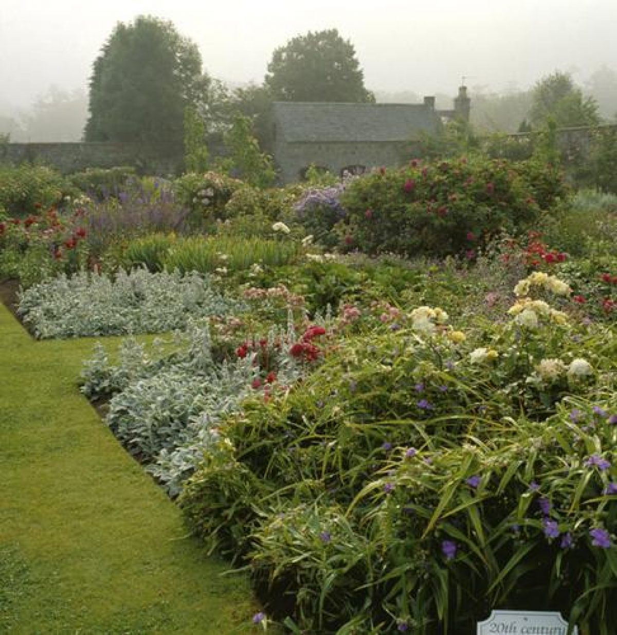
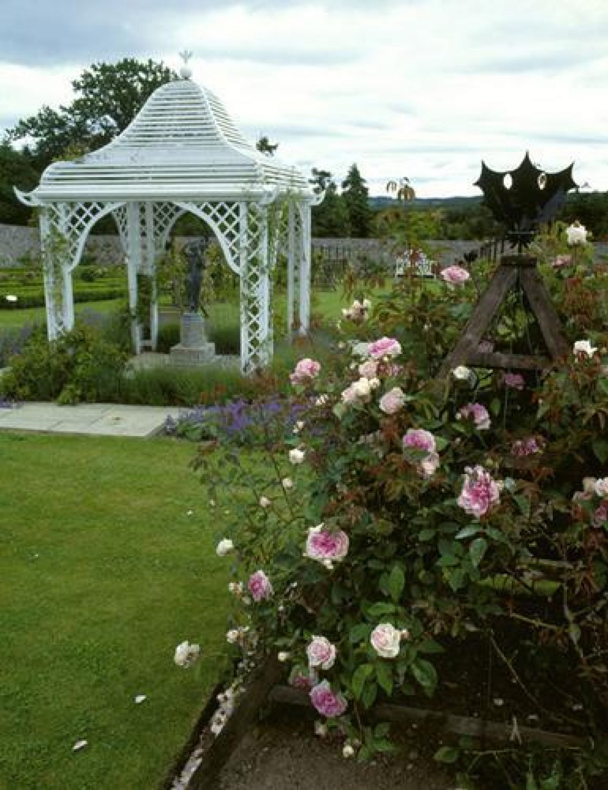
Between the castle and the walled garden, a small garden enclosed by fencing was created; its main feature is a pond which is recorded on the 2nd edition OS map of c.1910. The paths wind around the water and several small beds of shrubs. The area was densely planted by the 24th Laird who included a fine Fitzroya cupressoides and many other dwarf conifers including Juniperus hibernica, Picea brewerana and Chamaecyparis lawsoniana 'Stewartii'. Further additions of shrubs and waterside plants have been made by the NTS.
Walled Garden
The walled garden is thought to date from 1796 according to an account of that year paid for building a new garden wall. Earlier accounts show that a garden existed in 1775 and that improvements were made to its walls between 1778-87. It is not known, however, where this garden was actually located, if indeed it was on a different site from the present one, but produce was being sold from it in 1780. The 1st edition OS map of c.1860 indicates two cross paths within the garden walls, forming four equal compartments, and a fountain is shown as a central feature. When the National Trust for Scotland acquired the property in 1976, the garden was kept up in a similar form to the plan. Shortage of available labour resulted in an alternative use being sought, the last of which was a leased market garden. The garden is now derelict although some of the glasshouses remain and a few old fruit trees line the inner walls. To the south, potatoes and Christmas Trees have been planted in an outer enclosure.
- Visitor Access, Directions & Contacts
Telephone
01330 700334Access contact details
The grounds are open daily throughout the year. The castle and garden are open between April and October. Times vary seasonally.
Directions
Drum Castle is 3 miles west of Peterculter off the A93. The nearest bus stop is half a mile's walk from the castle. http://www.nts.org.uk/Property/Drum-Castle-Garden-and-Estate/Travel-information
Owners
The National Trust for Scotland
- History
The following is from the Historic Environment Scotland Gardens and Designed Landscapes Inventory. For the most up-to-date Inventory entry, please visit the Historic Environment Scotland website:
http://portal.historic-scotland.gov.uk/hes/web/f?p=PORTAL:DESIGNATIONS:0
Reason for Inclusion
An impressive 18th century landscape setting for the category A-listed Drum Castle, containing an oak wood dating back to the 1500s.
Main Phases of Landscape Development
No information available.
Site History
The existing structure of the designed landscape of Drum Castle was established at the end of the 18th century and incorporated the earlier features of the Church and Old Forest of Drum. The landscape appears to have been subject to alteration around 1850 and again in 1875.
The original Tower of Drum is thought to have been built in 1286 by Richard Cementarius, who became the 1st Provost of Aberdeen. In 1323 Robert the Bruce granted his secretary William de Irwin of Woodhouse the land and Royal Forest of Drum in return for his loyalty. William died in 1332 and was succeeded by his son, Thomas. The twelve subsequent lairds were all named Alexander Irwin, or, as the name was adapted to, Irvine.
The 9th Laird added the Jacobean extension to the original tower in 1619 by which time the family were the largest landowners in Aberdeen, Kincardine and Angus. Their loyalty to King Charles I and that of the Stuart cause, however, caused their prosperity to decline. Drum Castle was plundered by the Earl of Argyll's troops who, according to the historian Spalding, destroyed the 'pleasant garden planting' which existed at this time. The Irvines' support of the Stuart cause in the 1715 and 1745 Rebellions resulted in the forfeiture of parts of the estate. There was little improvement to the designed landscape until the latter years of the 18th century, when the 18th Laird was known to have subscribed to the Botanic Garden in Edinburgh. Records kept from his succession in 1775 until about 1796 suggest a considerable amount of activity in the garden. Alterations were also made to the house at this time and further work was carried out in 1850 and again in 1875.
In 1964 Mr H.Q. Forbes Irvine, the 24th Laird, made an agreement with the National Trust for Scotland that, on his death, the Castle, policies, Home Farm and 170 acres of woodland, including the Old Forest of Drum, would pass into its care. In 1976, this agreement came into force and Drum Castle, which had been held by the Irvine Lairds for over 650 years, passed into the care of the NTS.
Period
- 18th Century (1701 to 1800)
- Late 18th Century (1767 to 1800)
- Features & Designations
Designations
Historic Environment Scotland An Inventory of Gardens and Designed Landscapes in Scotland
Features
- Rose Garden
- Description: The walled garden is restored and replanted with varieties of old roses. It was re-opened in 1991 to celebrate the National Trust for Scotland's diamond jubilee.
- Earliest Date:
- Latest Date:
- Castle (featured building)
- Earliest Date:
- Latest Date:
- Key Information
Type
Estate
Purpose
Ornamental
Principal Building
Domestic / Residential
Period
18th Century (1701 to 1800)
Survival
Extant
Hectares
155.8
Open to the public
Yes
- References
References
-
Historic Scotland, 'Drum Castle', {Gardens and Designed Landscapes},
- Peter McGowan Associates {Drum Castle Historic Landscape Survey} (2000) Drum Castle Historic Landscape Survey
Contributors
Historic Scotland
-
Historic Scotland, 'Drum Castle', {Gardens and Designed Landscapes},