Introduction
The designed landscape around the 16th-century castle was laid out between the mid-18th and mid-19th centuries following plans drawn up by Thomas White. Further improvements were made in the mid- to late-20th century. The policies comprise parkland, woodland and a walled kitchen garden.
http://portal.historic-scotland.gov.uk/hes/web/f?p=PORTAL:DESIGNATIONS:0
Type of Site
The late 18th century designed landscape of parkland, enclosing woodlands and walled garden with ornamental gardens makes a sinificant contribution to the scenic quality of the locality.
Location and Setting
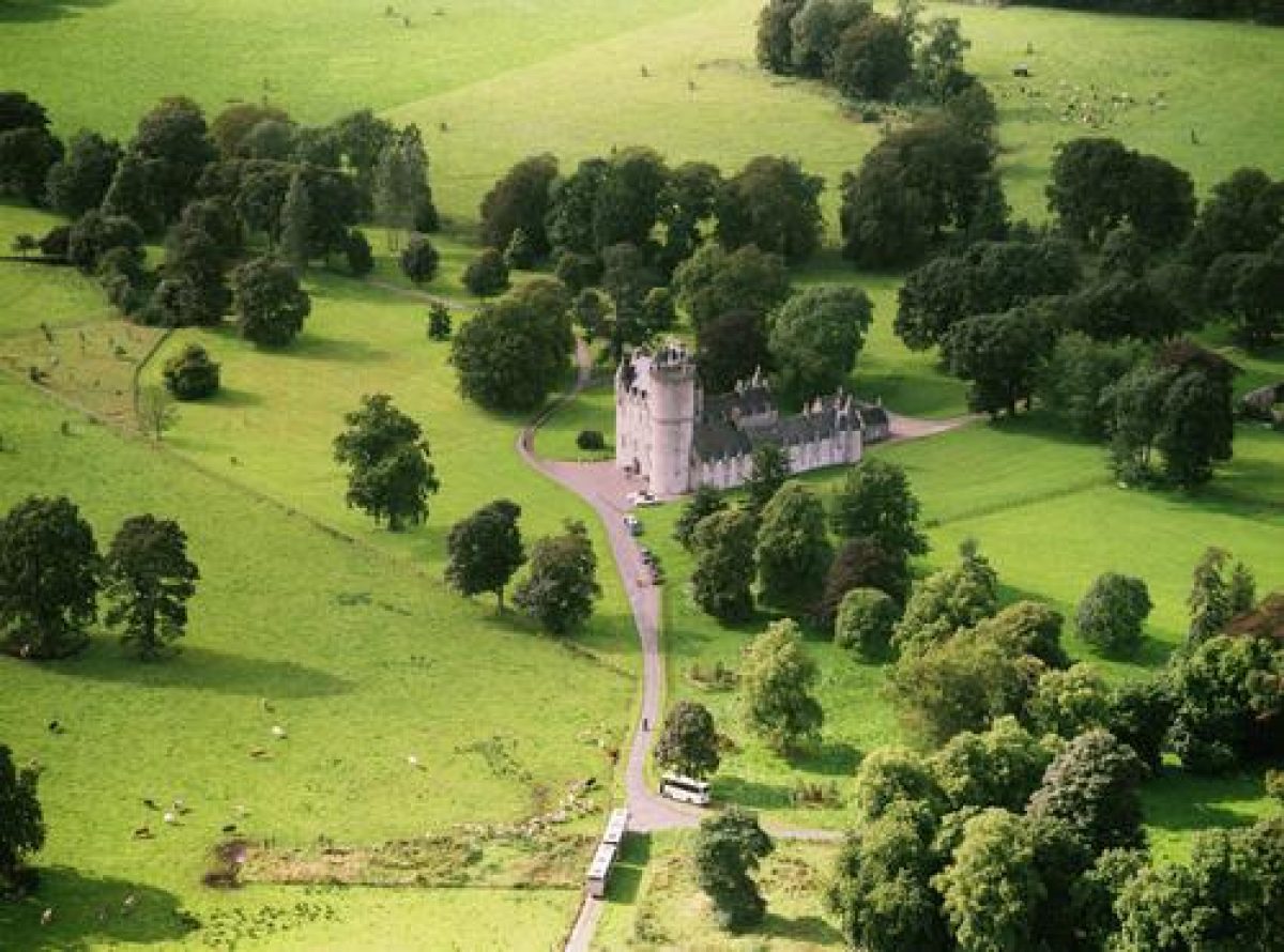
Castle Fraser is situated in the foothills of the Grampian Mountains approximately 2 miles (3km) south of the village of Kemnay and some 13.5 miles (22km) west of the city of Aberdeen. A stone wall runs along the edge of a minor road between Kemnay and Dunecht forming the western boundary of the designed landscape. The surrounding landscape is rolling agricultural land, the pattern of which is broken only by commercial forestry and shelterbelts. Magnificent views can be gained from the northern edges of the site across the valley of the River Don to the Bennachie Hills in the north which rise to a height of 1,730' (528m) at Oxen Craig and 1,698' (518m) at Mither Tap. The woods of Castle Fraser are of some significance in the designed landscape.
Castle Fraser is situated within some 369 acres (149ha) of designed landscape which extends north to the Muchalls Burn, south to the woodland at the South Lodge, west to the Dunecht/Kemnay road, and east to the woodland at Walkend. The land owned by the National Trust for Scotland is confined to some 26 acres immediately surrounding the castle.
Documentary map evidence of the development of the designed landscape is provided by General Roy's map of c.1750, a plan of the policies of c.1780, a plan for improvements proposed by Thomas White of 1794, a map of the policies by J. Johnson and alterations of 1819, and a book of plans of the lands of Castle Fraser of 1846, in addition to the 1st edition OS map of c.1860 and the 2nd edition OS map of c.1900. There is also a series of watercolours painted by James Giles between 1841- 1862. Comparison of the plans shows that prior to the 19th century, the designed landscape was largely confined to the area around the Castle and only four avenues extended out to the north, south, east and west. The present extent of the designed landscape has remained relatively unchanged since the early 19th century.
Landscape Components
Architectural Features
Castle Fraser, listed category A, was originally a 15th century tower house which was first converted c.1576. The architect is thought to have been Thomas Leiper whose work included the addition of a round tower at the south- east corner and a square tower at the north-east corner of the building. Work ceased in 1588-89 on the death of Michael Fraser at which time only two storeys were complete. Thereafter the west end of the 15th century tower was demolished and two floors were added to the entire house with an extra storey added to the round tower. This work was carried out by master mason, John Bell, in the early 17th century. The elaborate upper detailing of the building was also carried out by him between 1617-18. James Leiper is known to have paved the floor of the hall in 1614 and is thought to have been responsible for the two-storey court built between 1621-36. Alterations were made to the interior c.1795 which were removed after World War II. William Burn was commissioned to prepare proposals for minor interior alterations in c.1816. The two small gatehouses, with an archway which enclosed the Castle courtyard, were built c.1820. John Smith prepared designs for further alterations between 1830-36 including designs for a library c.1830 and, whilst it was carried out in later years, many other proposals were not. The Castle is now owned by the NTS as is the Walled Garden and old Laundry. All other buildings and architectural features are privately owned.
The Walled Garden, listed category B, is thought to have been built c.1795. The old laundry, converted and now used as a gardener's house, is situated in woodland to the east of the walled garden.
The Stable-block, listed category A, was built in 1795. The architect was John Paterson. It was converted between World Wars I and II to a family house and estate office. The North and South Lodges remain. The West Lodge, listed category B, is thought to have been built c.1820-30. Bristow Cottage, listed category B, is thought to have been built c.1825. A Standing Stone is situated in a field known as the John Bell Field to the north-west of the Castle. A Well, listed category B, stands near the South Lodge and is thought to have been built c.1795. The sundial is listed A and stands in the walled garden on the site of a former well.
Parkland
The parkland was originally laid out in its present informal design in the latter years of the 18th century for Miss Elyza Fraser. An improvement plan by Thomas White was commissioned in 1794 but reference to the plan of the policies in 1846 indicates that the informal planting suggested by White was not executed. A pond situated to the north-east of the stable-block is shown on the plan of 1788. It was used as a watering place for the Home Farm and stables and it remains today. White's proposal for a serpentine lake appears on the 1846 map and Miss Elyza is said to have kept a boat and two swans on the lake. The feature, however, had been removed by the 1st edition OS survey of c.1860.
It is recorded that in c.1820 Colonel MacKenzie Fraser made various alterations to Miss Elyza's lake, referred to in letters as 'deepening the canal'. This was on land immediately to the east of the Castle which is still inclined to be boggy. The improvements made following White's plan included the 'Broad Walk', an avenue of sycamores extending north from the Castle. It has been successively replanted mainly with sycamore but some ash have also been included. It now includes trees of between 10 to about 200 years. An avenue which extended south of the Castle on the 1788 plan has now gone. Driveways sweep through the park providing glimpses of the picturesque landscape from the north, south, east and west.
The parkland to the north of the stable-block is enclosed by a ha-ha; most of it has been retained by the Estate and is fenced off from the 26 acres surrounding the Castle now owned by the NTS. Between the Castle and the south side of the walled garden a variety of ornamental trees are well established. Other ornamental trees have been planted beyond the west boundary of the NTS parkland.
Woodland
The woodlands were laid out as part of Miss Elyza Fraser's improvements of c.1795. They enclose the policies on all sides and provide a significant scenic impact on the landscape. Miss Bristow's Wood is named after the friend of Miss Fraser who is said to have spent some £96 on its planting between 1797 and 1800. Colonel MacKenzie Fraser added many trees to the policies as shown by his records which remain today. Over 80% of the woodlands have had to be replanted since the gale of 1953 when a great many old trees, particularly beech, were lost.
Walled Garden
The plan of the policies of 1788 shows the garden situated on the east side of the Castle, south of which lay an area known as the 'Walks and Birks'. The 'Cherry Yard' was situated to the south of the Castle, and the Ducat Yard to the west of it. The present garden was built in accordance with the improvement plan by White. In the course of this work the old gardens were lost and their sites reverted to parkland.
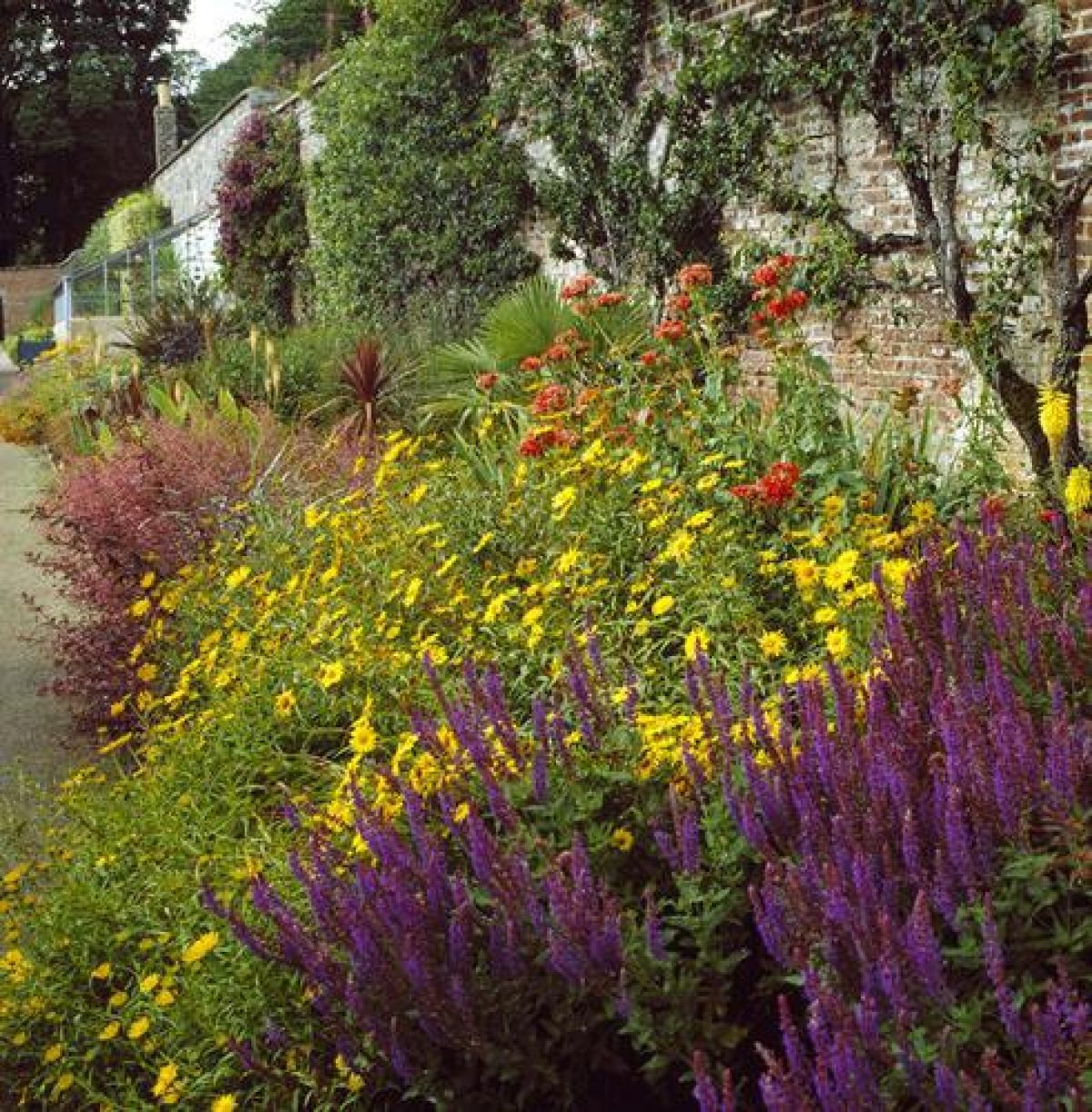
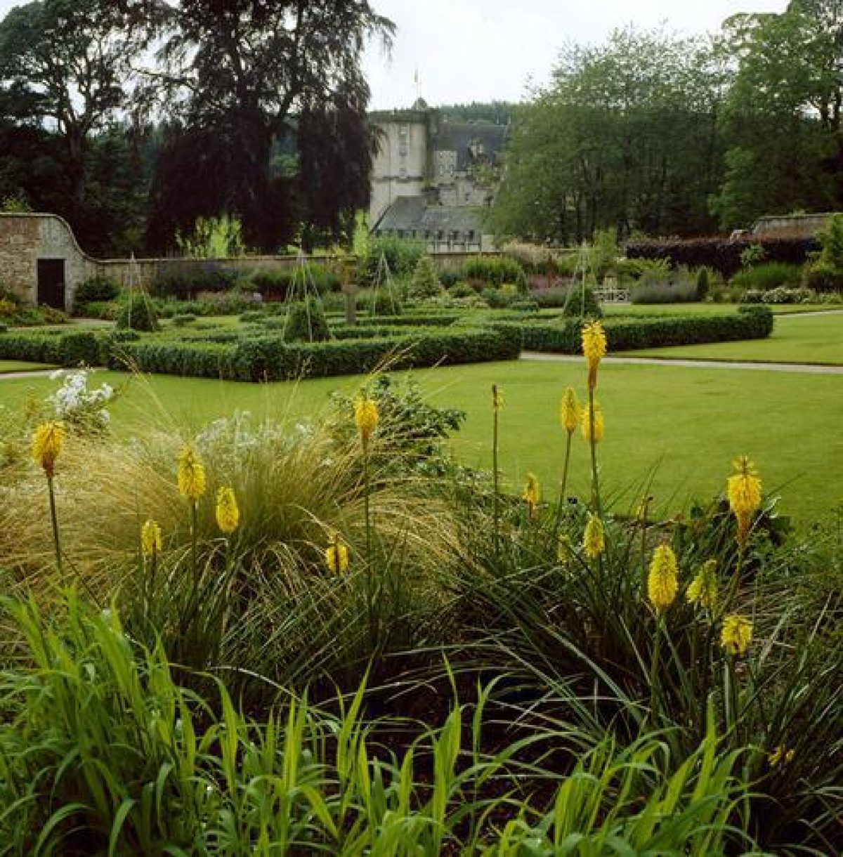
Reference to the 1st edition OS plan of c.1860 shows the layout of the walled garden to be, typically, four equal areas separated by crosspaths within the rectangular enclosure. The garden was cultivated up to 1974 when it was sown out in grass. Since its acquisition by the NTS, it has been redesigned by the Trust's Gardens Adviser, Eric Robson. The old layout can still be seen through the existing grass cover in favourable conditions. The new layout is mainly ornamental; a quarter of the walled garden is planted with vegetables and there are fruit trees espaliered on the inner walls. An additional area to the east of the garden is used for vegetables and fruit growing and propagating. Some plants on the walls remain from the 1900s, eg a fine Euonymus specimen which stands by the entrance to the garden on the north wall. The small two-storey building in the north wall of the garden was once the gardener's house. The present ladies' and gentlemen's cloakrooms were made from a former potting shed. The NTS has made a new entrance in the north-west corner of the garden to enable access for a tractor.
Herbaceous borders line three inner walls of the garden. The border along the outside of the south wall was laid out in 1956 by Jim Russell of Sunningdale Nurseries, who also worked at Crathes, but it was reduced in size by the Trust after 1977. The area within the borders is lawn on which specimen trees and shrubs have been established. The central feature of the garden is the sundial which is enclosed by a rose bower of golden jubilee roses, gifted to the NTS in 1981. The sundial was once a feature of a garden immediately below the east wing of the Castle. It was removed by Mrs Fraser when she left in 1921 and returned by the Hon Clive Pearson after her death, and has been placed as the central feature in the walled garden, where once there was a well, as shown on the 1st edition OS map of c.1860.
- Visitor Access, Directions & Contacts
Telephone
01330 833463Access contact details
Garden and grounds open all year. The castle is open between April and October. Days and times vary seasonally.
Directions
Castle Fraser is 4 miles north of Dunecht off the A944. http://www.nts.org.uk/Property/Castle-Fraser-Garden-and-Estate/Getting-there/
Owners
The National Trust for Scotland
- History
The following is from the Historic Environment Scotland Gardens and Designed Landscapes Inventory. For the most up-to-date Inventory entry, please visit the Historic Environment Scotland website:
http://portal.historic-scotland.gov.uk/hes/web/f?p=PORTAL:DESIGNATIONS:0
Reason for Inclusion
The 18th-century landscape provides an outstanding setting for the category A-listed castle, and comprises parkland, woodland and a walled garden.
Main Phases of Landscape Development
Late 18th century and the first half of the 19th century with further improvements within the 19th century layout between 1921 and the 1970s.
Site History
The designed landscape was laid out in the mid and late 18th century and the first half of the 19th century. An improvement plan was prepared by Thomas White in 1794. Reference to the 1846 survey of the policies indicates that its suggestions for the siting of the stable-block, walled garden, the east drive and the serpentine lake were carried out but the planting proposals appear to have been ignored. The lake disappeared between 1846 and the survey for the 1st edition OS map of c.1860. Further improvements were made within the 19th century layout between 1921 and the 1970s.
The family of Fraser of Castle Fraser are descended from the Frasers of Cornton (Stirlingshire). In 1454, on the break up of the estates of the Earldom of Mar, the lands of Muchall (later Castle Fraser) were created into a barony which James II granted to Thomas Fraser of Kilmundy. It is unclear whether a house existed on the site at the time when the charter was granted or if this first laird built a new house.
Michael Fraser, the 6th Laird, succeeded his father in 1565 and, within five years, had begun an extensive programme of alterations and additions to the Castle. His son, Andrew, continued the work after his father's death c.1588 and was largely responsible for the formation of the Castle as it remains today, employing master mason, John Bell, to carry out much of the work. In 1633, three years before his death, Andrew was created Lord Fraser of Muchalls. His son, the 2nd Lord Fraser, was an active Covenanter and it was during his time as laird that the policies were sacked by the forces of Lord Aboyne although the Castle itself was defended. Charles, 4th Lord Fraser, succeeded in 1674 to an estate which was somewhat impoverished due to the actions of his father. He was 'out' in the 1715 uprising and met an untimely death in 1716 when the title of Lord Fraser was also lost. His successor was Charles Fraser of Inverallochy whose exact relationship to the 4th Lord is subject to confusion. He was created titular Lord Fraser by the Old Pretender in 1723. His son, William, succeeded in 1787 but died unmarried in 1792 when the estate of Castle Fraser passed to his unmarried sister, Elyza Fraser, then aged 56.
Miss Elyza, 1734-1814, was responsible for the extension and improvement of the policies to their present structure. She commissioned Thomas White to prepare an improvement plan of the estate in 1794. Her friend, Miss Bristow, is thought to have influenced many of Miss Elyza's decisions, in particular the woodland in the south of the policies which, in addition to an estate cottage, was named after her. Another great friend, James Byres of Tonley, designed Miss Elyza's mausoleum.
Colonel Charles MacKenzie Fraser inherited the estate from Miss Elyza, his great- aunt. He made several extensions to the house and remodelled the earlier 17th & 18th century interiors. He was, however, a great agricultural 'improver' and continued the work on the policies which his predecessor had begun. In later years it is thought that James Giles may have advised him on the design of the landscape. Records were kept of almost all activities in the Castle and policies which have proved an invaluable source of information as to their way of life. Colonel Charles Mackenzie Fraser was succeeded by his only surviving son, Colonel Frederick, in 1871 and, on his death in 1897, the estate was left in the hands of trustees.
The male heir was Thomas Fraser Croft Fraser who showed little interest in the estate, his work being incompatible with that of a country landowner; he ultimately became Privy Chamberlain to the Pope and Master of Ceremonies at St Peter's. Thus the widow of Colonel Frederick sold the estate to Lord Cowdray in August 1921 for his 2nd son, the Hon Clive Pearson. He commissioned Sir Robert Lorimer to survey the Castle and, whilst he made many proposals for alterations to the Castle between 1922- 27, none of his ideas were acted on. Dr William Kelly was ultimately commissioned to restore the Castle and work was carried out until World War II. The theft of lead in 1950 from the roofs of the 19th century additions prompted their demolition and restoration of the courtyard into its original form. In 1947 the estate was passed to Mrs Lavinia Smiley, daughter of the Hon Clive Pearson, and, with her husband, Major Michael Smiley, she continued the restoration begun by her father. The work was completed in the 1960s, the stable-block having already been converted into the family home. Except for two wings the Castle had not been lived in since 1921 and, in 1976, it was given to the NTS, together with some 26 acres of surrounding land.
Period
- 18th Century (1701 to 1800)
- Late 18th Century (1767 to 1800)
- Associated People
- Features & Designations
Designations
Historic Environment Scotland An Inventory of Gardens and Designed Landscapes in Scotland
Features
- Avenue
- Description: A sycamore avenue running north from the castle that was part of the original 18th-century layout. It is now partly replanted.
- Sundial
- Description: The sundial is situated in the walled garden.
- Well House
- Earliest Date:
- Latest Date:
- Garden Wall
- Description: The 18th-century walled garden was recreated by the National Trust for Scotland in the early-21st century. It has herbaceous borders and some productive areas, including old espaliers.
- Earliest Date:
- Latest Date:
- Castle (featured building)
- Earliest Date:
- Latest Date:
- Key Information
Type
Estate
Purpose
Ornamental
Principal Building
Domestic / Residential
Period
18th Century (1701 to 1800)
Survival
Extant
Hectares
146
Open to the public
Yes
- References
References
-
Historic Scotland, 'Castle Fraser', {Gardens and Designed Landscapes},
- Peter McGowan Associates {Castle Fraser Historic Landscape Survey} (1996) Castle Fraser Historic Landscape Survey
-
Historic Scotland, 'Castle Fraser', {Gardens and Designed Landscapes},