Introduction
An extensive public park (74 hectares) opened in 1925 on the site of a larger 18th-century landscape park originally of 240 hectares. The park features 3 separate gardens: the Old English Garden, the Rock Garden and the Peace Garden. The park boasts a wide array of sporting and visitor facilities including water sports on the 7.8 hectare lake.
Terrain
The site is relatively flat, sloping moderately to the south with the mansion located on a ridge of high ground that runs east/west through the site, this ridge effectively dividing the park into two halves.www.historicengland.org.uk/listing/the-list
Remains of an 18th century landscape park attributed to Nathaniel Richmond.
DESCRIPTION
LOCATION, AREA, BOUNDARIES, LANDFORM, SETTING
Danson Park lies to the north of the A2 trunk road, East Rochester Way, between Welling to the north-west and Bexleyheath to the east. Suburban housing almost entirely encloses the site, with the A221, Danson Road providing the eastern boundary, Danson Mead and Parkview Road the northern boundary, and Radnor Avenue and a footpath to the rear of houses in Merlin Road the west boundary.
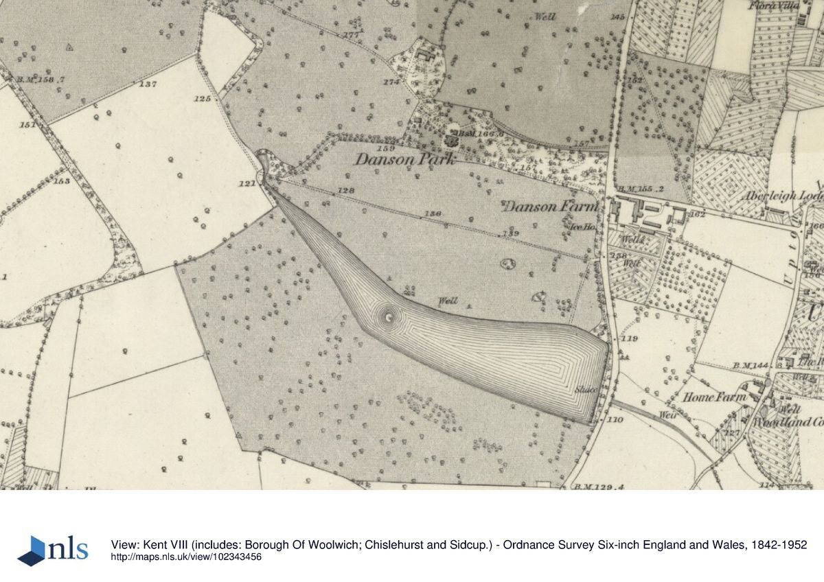
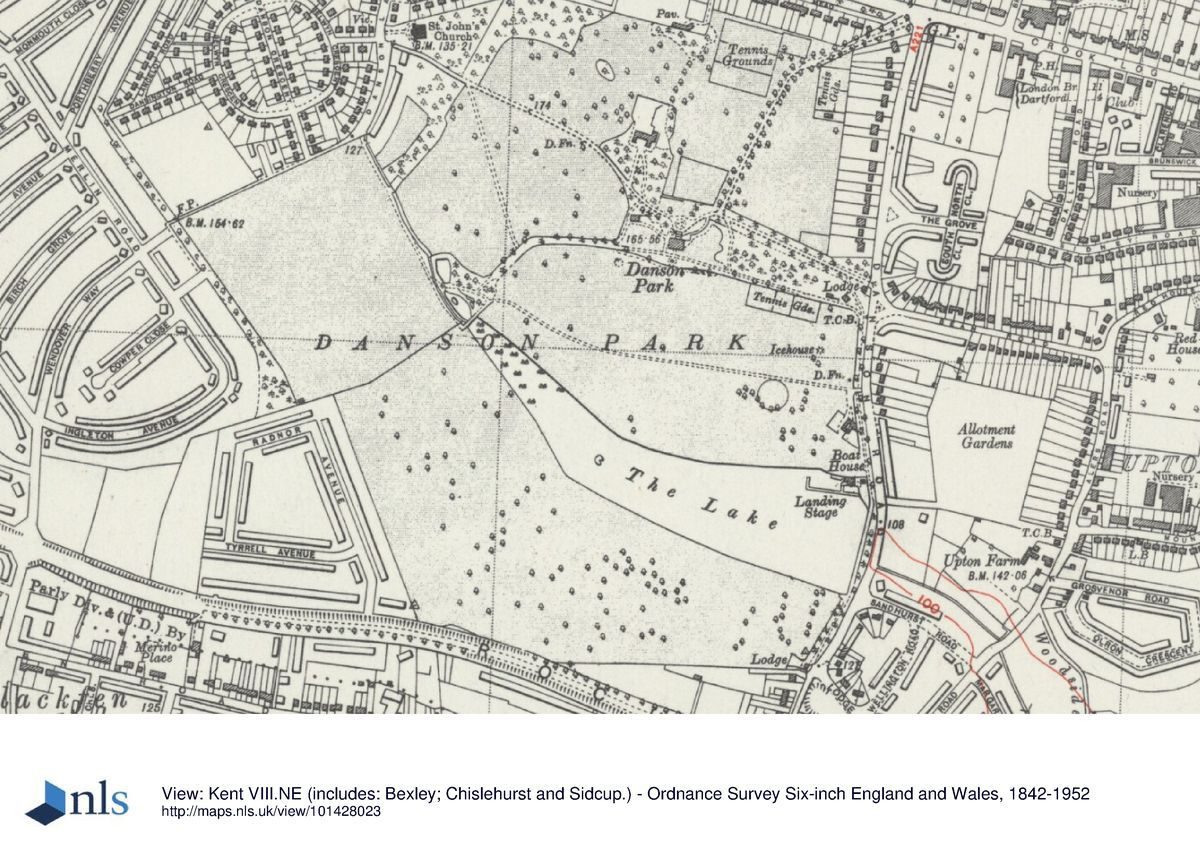
The c 74ha site, enclosed within C20 walls and railings, is relatively flat, sloping moderately to the south with The Mansion located on a ridge of high ground that runs east/west through the site, this ridge effectively dividing the park into two halves. A valley which runs east/west across the southern part of the site was infilled by a lake behind an artificial dam. The height of the earth bank at the dam shows the significant depth of the valley. The land rises southwards in a ridge beyond the lake.
ENTRANCES AND APPROACHES
The main entrance to the site is from Danson Road to the east and follows the line of the drive remodelled c 1897 (OS). The new drive is shown crossing parkland before terminating at a turning circle on the north front of The Mansion. At the same time the access drives to the north front were realigned so that they focused around the turning circle rather than as previously, on the front steps. The main entrance drive today (1997) has mown grass borders and C20 trees and shrubs planted at intervals along its length; it is screened from the C18/C19 parkland by clipped hedges. It passes c 40m to the north of The Mansion, with the Old English Garden to the north and the turning circle to the south, and continues c 500m north-west past, to the north, the C19 stable block (listed grade II*), before terminating at the Danson Lane Gate. On the east side of the Old English Garden a drive, now a tarmac footpath, passes through former parkland and connects the C20 Crook Log entrance with the main drive. This was the main entrance to the municipal park and is marked by ornate iron railings and gates.
PRINCIPAL BUILDING
The Mansion (listed grade I) stands on high ground with fine views out over falling ground to the south. It was built from c 1762 for John Boyd by Sir Robert Taylor and was originally called Danson Hill. The Mansion was completed by 1770 with some of the interiors having been designed by Sir William Chambers. The house is of Portland stone and has three storeys, a piano-nobile, and a half storey above a rusticated stone basement. The principal apartments are on the first floor. The walls are rendered and the roofs low and slated. The entrance is on the north side, up a grand flight of nineteen wide steps to a balcony as wide as the projected pedimented centre.
GARDENS AND PLEASURE GROUNDS
To the north of the entrance drive, opposite The Mansion, is the Old English Garden, which was laid out on former parkland and probably dates from the earliest stages of the municipal park in the 1920s. It has a pergola, paved paths, formal plant beds, and modern seats.
Some 50m north-east of The Mansion, a C20 perimeter path leads c 80m south from the entrance drive across an area of lawn to the east of the house. This area, open parkland on Richmond's plan of 1762/3, had been planted with regular rows of trees by 1805 (estate plan) and subsequently (by 1830) thinned (plan of the property of John Johnson). The area immediately around the house is separated from the parkland by a hawthorn hedge to the east, and a beech hedge planted c 1970 to the south of the C18 ha-ha after it was filled in (mid-late C20). The line of the ha-ha, which would have divided the gardens from the parkland, is still recognisable as a distinctive step at the edge of the lawn. At about the same time (c 1860) as the beech hedge was planted, the southern perimeter path which ran between the ha-ha and The Mansion was re-routed to the south of the hedge. Today (1997) the hedge screens any view of the garden around The Mansion but three late C19 trees survive on the lawn to the east along with other C20 trees. Some 80m south east of The Mansion the C20 perimeter path turns west and continues for 160m to the south side of the beech hedge where it turns north and links up with the mid C19 west garden path which led around the western lawn to the Winter Garden. The Winter Garden, constructed by 1844, has been lost, as have the rose arches over the path. The west lawn was first shown as lawn with trees by c 1830 (Plan of the property of John Johnson) but the nature of the land before then is not clear. Mature trees including cedar of Lebanon (shown on OS 1860) and the shrubbery along the northern edge of the western garden are thought to survive from the mid C19, though contemporary paths through the shrubbery have been lost.
At its western end the southern perimeter path divides, one spur continuing north as the western perimeter path while the other runs south and leads down to the C20 formal garden and the water garden at the west end of the lake. The path is separated from the parkland by low hedges and shrubs, as well as some mature trees possibly surviving from the thin belt of trees which followed the contour down to the south-west of the house (sale plan, 1805). The C20 water garden, separated from the lake by a brick footbridge, is situated in the area where, in the C18, the Danson Brook fed into the lake. The two pieces of water that make up the water garden are recorded on the OS 1st edition map of 1865.
PARK
The land laid out as parkland lies to the south, west, and north of The Mansion. The land to the south slopes away from the house, levelling off before the lake and then rising slightly again to the south of the lake. The level areas of land are used for football in the winter months. Tree cover is sparse compared with the clumps and blocks of woodland shown on the C18 and C19 plans, and consists largely of a scatter of C20 individuals with more concentrated planting along the banks of the lake. Occasional mature trees, possibly C18/C19, survive, notably the 'Charter Oak' to the north of the lake. The C20 planting at the west end of the lake and around the water garden contrasts with the open aspect of the late C18 and early C19 (sale plan, 1805) and screens the view of the house from the south-west parkland. C20 plantings help to screen the site from the A2 trunk road which runs along the southern boundary. There is an ice well close to the eastern edge of the park.
The lake is the most striking feature on Richmond's plan (1762/3) which shows a system of three interlocking lakes connected and divided by curving plantations and a false island. The 1805 sale plan shows a simplified design similar to the Lower and Middle Lakes on the C18 plan and similar to the piece of water at Danson today (1997). The lower (eastern) section of the lake is known to have been under construction by 1770 when Sir William Chambers was commissioned to design a temple at its eastern end and a bridge at the western end. The lake was filled in during the Second World War as it was considered an obvious landmark for enemy aircraft but was subsequently re-excavated; it is currently used for boating. There is a cafe and boathouse (C20) on the north-east shore.
Little of the original parkland survives to the north and west of The Mansion. The stable block to the north of the house is thought to have been designed by George Dance the younger; this has been converted to a restaurant and is fronted by a public car park. Much of the C18/C19 park and woodland surrounding The Mansion has been lost to sport facilities which include tennis courts and playgrounds created since 1924. The views back to the house from the west are obscured by trees on the garden boundary.
REFERENCES
T Fisher, The Kentish Traveller's Companion (1776)
E Hasted, The History and Topography of Kent (1797)
Country Life, 142 (6 July 1967), pp 123-5
D Stroud, Capability Brown (1975), p 222
M Scott, The Story of Danson (1982)
B Cherry and N Pevsner, The Buildings of England: London 2 South (1983), pp 137-8
D Jaques, Georgian Gardens, the reign of nature (1983), pp 84-5
Danson House Historic Survey, (Colson Stone 1997)
Brown, D A, 'Nathaniel Richmond (1724-1784), 'Gentleman Improver', University of East Anglia, unpublished PhD thesis, (2000)
Maps [all reproduced in Colson Stone 1997]
Plan of Danson and Adjacent Parks, 1753
Rev Joseph Spence, Plan drawn up by Rev Joseph Spence on a visit to Danson, May 1763
Attributed to Nathaniel Richmond, A Plan for the alterations proposed at Danson, 1762/3
Andrews, Drury, and Herbert, Map of Kent, 1769
Sale Plan of an Estate called Danson, 1805
Plan of the property of John Johnson, dated 1823-30
Inslip, Plan of an Estate called Danson in the County Of Kent, 1823-30
Tithe map for Bexley parish, 1844 Sale plan, 1922
OS Surveyor's drawing, 3" to 1 mile, 1799
OS 6" to 1 mile: 1933 edition
OS 25" to 1 mile:
1st edition published 1865
2nd edition published 1897
Illustrations
George Barrett Snr, Portrait of Danson, 1766 (in Colson Stone 1997)
Description written: September 1997 Amended: October 2001
Register Inspector: LCH
Edited: November 2001
The list entry was enhanced in 2016.
- Visitor Access, Directions & Contacts
Telephone
020 7259 5688Website
http://www.hha.org.ukAccess contact details
The site is open from 7.30am - dusk Mon-Fri, 9am - dusk Sat/Sun/Bank Holidays. Splash Park open summer 10am-6pm, winter 10am-2pm weekdays/-3.30pm weekends
Directions
Rail: Bexleyheath. Bus: 89, 96, B13, B14
Owners
LB Bexley
- History
The former landscape park which the public park now occupies was designed and laid out in the mid 18th century by Lancelot Brown and a Mr Richard for wealthy merchant John Boyd. The Palladian style house was designed by Robert Taylor who was also the architect responsible for designing the bank of England.
As Bexley's flagship park, Danson Park is recognised nationally for its historic landscape and buildings. In 2004 the Council successfully obtained a grant from the Heritage Lottery Fund for the restoration of the historic setting of the Grade I Listed Danson House and surrounding area.
The following is from the Register of Parks and Gardens of Special Historic Interest. For the most up-to-date Register entry, please visit the The National Heritage List for England (NHLE):
www.historicengland.org.uk/listing/the-list
HISTORIC DEVELOPMENT
The original Danson estate, known in the 16th century as Dansington, was, between 1571 and 1723, enlarged from 100 acres (about 41 hectares) of woodland and arable to 250 acres (about 104 hectares) ornamented with waterworks and fishponds (Colson Stone 1997). In 1723 the owner John Styleman leased the estate to John Selwyn, on condition that he spend at least £1000 improving the estate which he did by buying up parcels of adjoining land, ornamenting the landscape, enlarging the house, and in about 1745, re-routing the public road from Danson to Blendon. Selwyn died in 1751 and the lease of Danson was held by Styleman's widow until 1753 when John Boyd (later Sir John) took a full repairing lease on the original Danson House. By 1763 Boyd was making plans to rebuild the mansion and a plan dated 1763 which was drawn up by Reverend Spence when he visited Danson shows the site of the new mansion and, like another entitled 'A plan for the proposed alteration at Danson Hill' (1762-1763), shows a mansion standing alone on its present location.
The new mansion was augmented by 1766 with two wings, one for stables and one for offices; these are shown on Andrews, Drury, and Herbert's Map of Kent (published 1769) and on a painting by George Barrett Snr (1733-1807). Landscaping of the park appears to have been undertaken at the same time as the new house was built. A plan for the proposed alterations at Danson Hill c 1762/3, once attributed to Lancelot Brown (Fisher 1776; Hasted 1797; Stroud 1975), is now believed to have been drafted by his then assistant, Nathaniel Richmond (Jacques 1983; Brown 2000).
Sir John Boyd died in 1800 and was succeeded by his son, also Sir John, who undertook a comprehensive programme of repair and enhancement between 1802 and 1804 before selling the house to cover his father's outstanding debts. During this time the wings of the house were demolished and new stables (Listed Grade II*) were constructed on a separate site at a greater distance from the house, using materials from the demolished wings.
The estate plan drawn up in connection with the sale of the property to John Johnston in 1805 shows details of the many alterations and improvements made by the Boyds. Other than ornamentation to the northern boundary, few alterations were made during Johnston's lifetime (estate plan, 1823-1830) but the Johnston family, who held the estate until 1862, were probably responsible for improvements recorded on the Ordnance Survey 1st edition map (1865).
The new owner, Alfred Bean, and his descendants owned Danson between 1862 and 1922 and during that time a number of rustic lodges and a circular summerhouse were built. In 1924 Bexley Urban District Council acquired part of the estate named as Danson on the 1922 sale map; this included the house, stables, lake, and 74 hectares of parkland. The remainder of the estate was developed for housing and the construction of the A2 trunk road. In 1925 Danson was opened as a public park, the house, known as The Mansion, housing a museum and a cafe. Many new facilities have been created since 1925, most of them in the area of the park to the north of the house.
The Mansion was closed in 1970 and has remained empty to the present day. It is currently (1997) undergoing restoration and the stables have been converted for use as a restaurant.
- Associated People
- Features & Designations
Designations
The National Heritage List for England: Register of Parks and Gardens
- Reference: GD1118
- Grade: II
The National Heritage List for England: Listed Building
- Reference: Danson House
- Grade: I
Site of Local Importance for Nature Conservation
Tree Preservation Order
Green Flag Award
Features
- Tree Feature
- Description: A large oak tree in the centre of Mid Park has been recognised as one of the 'Great Trees of London'. It is now over 200 years old. The tree was part of the Danson Mansion estate and now provides a central feature to the park scene. It was under this tree on 30 September 1937 that Lord Cornwallis presented the Charter which elevated Bexley from an Urban District Council to a Municipal Borough. This oak tree is now featured on the Borough Coat of Arms. The tree has now been enclosed to protect its delicate root system and increase the amount of valuable moisture.
- Walk
- Lake
- Description: The 7.8 hectare lake offers fishing, boating, sailing and other water sports.
- Mansion House (featured building)
- Earliest Date:
- Latest Date:
- Bowling Green
- Boat House
- Stable Block
- Description: Now a public house.
- Key Information
Type
Park
Purpose
Recreational/sport
Principal Building
Domestic / Residential
Survival
Part: standing remains
Hectares
74
Open to the public
Yes
- References
References
- Stroud, D {Capability Brown} (1975) p 222 Capability Brown (Country Life article)
- {English Heritage Register of Parks and Gardens of Special Historic Interest} (Swindon: English heritage 2008) [on CD-ROM] Historic England Register of Parks and Gardens of Special Historic Interest
- Cherry, B. and Pevsner, N. {The Buildings of England: London 2: South} (Harmondsworth: Penguin, 1983) pp 137-138 The Buildings of England: London 2: South
- {Danson Park Historic Restoration Management Plan} (2004) Danson Park Historic Restoration Management Plan
- Scott Wilson Resource Consultants {Danson Park, Bexley: Historical Restoration Management Plan} (1999) Danson Park, Bexley: Historical Restoration Management Plan
Contributors
London Parks and Gardens Trust