Introduction
At Croft Castle a park with 17th-century avenues, late 18th-century landscaping, and 19th- and 20th-century trees surround the castle and central garden area.
Terrain
Croft Castle lies in the lower, southern part of the park.www.historicengland.org.uk/listing/the-list
A landscape park with notable survivals of sweet chestnut plantings of probable 17th-century date associated with a country house.
DESCRIPTION
LOCATION, AREA, BOUNDARIES, LANDFORM, SETTING
Croft Castle lies 12km south-west of Ludlow, the park being bounded to the south by the B4362 Ludlow to Presteigne road. To the south of the road the ground falls away to the River Lugg and Leominster, 8km to the south-east, while to the north it rises ever more steeply, up to the wooded slopes of Yatton Hill and the Iron Age hillfort of Croft Ambrey (scheduled ancient monument) which lie on the northern edge of the park. To the west the park reaches almost to the River Lugg, while to the east it extends across the Fishpool Valley to abut Bircher Common. Croft Castle lies in the lower, southern part of the park adjoining the medieval parish church of St Michael. The area here registered is c 290ha.
ENTRANCES AND APPROACHES
The main approach is from the east, the park being entered at the hamlet of Cock Gate on the B4362. The two-storey stone and timber-framed gate lodge is late C19 or early C20, although incorporating older building materials. About 100m to the north-west is a single-storey L-plan building with gothick detailing of early C19 style, in fact a disguised late C20 concrete block bungalow. The east drive, which runs along the west edge of the Fishpool Valley, is tree lined for the whole of its 1km length. The oldest trees lie along the central 600m, and are predominantly oaks. The first 200m of the drive past the lodge were planted with oaks in the late C20. As the drive approaches the Castle beech is the main species. The Cock Gate Drive was probably created c 1790, about the time the gothick curtain wall (listed grade II) at its end was built. A drive, present by c 1880, returns south to the B4362 from east of the pleasure grounds.
A single-storey, stone, gothick lodge of early C19 date at Lucton, 2km south-west of the Castle, marks the end of a former carriage drive which ran to Croft via a gothick bridge over Lucton Lane (demolished 1947 x 1958) and the Chestnut Avenue. The western section of the drive was also oak lined, and extensive replanting took place in the late C20. Lucton Drive was probably created after the Croft and Lucton estates were reunited c 1810.
PRINCIPAL BUILDING
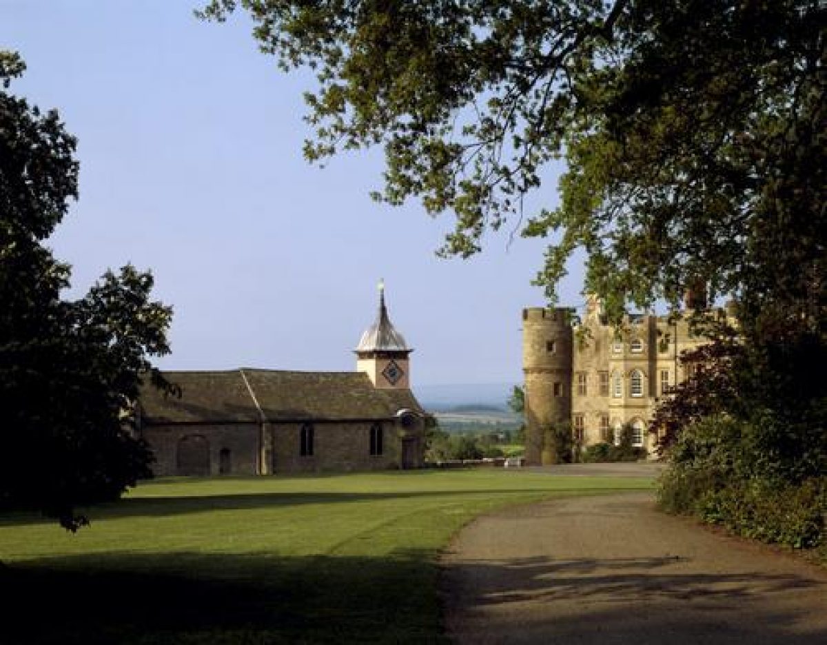
Croft Castle (listed grade I) is a large and irregular late C14 or early C15 castle with four corner towers. After slighting in the Civil War the Castle was rebuilt and extended with a north wing. About 1765 the Castle was extensively remodelled both internally and externally by Thomas Farnolls Pritchard (1723-77), its gothick appearance owing much to that phase of work. The north wing was demolished in 1937.
Some 30m east of the Castle is St Michael's church (listed grade I), while to its north-east are the late C18 stables (listed grade II) and early C19 Home Farm complexes.
GARDENS AND PLEASURE GROUNDS
The grounds are entered via a crenellated gothick Curtain Wall with towers, probably of the 1790s, which straddles the approach drive from the east c 200m north-east of the Castle. From this a sandstone-rubble ha-ha (probably constructed slightly later, and possibly after 1825) runs south, defining both the grounds and the east side of an inner park which extends c 200m south and west of the Castle. A shrubbery runs along the north side of the drive once it passes the Curtain Wall, while to the south the East Lawn with occasional specimen trees extends to the church. West of the church, and extending along the south and west sides of the Castle is a terrace with a low crenellated wall (listed grade II), again of the 1790s. Behind, north of the Castle and linking it with the walled kitchen garden, is the North Forecourt Garden, laid out c 1960 in the area of the north range demolished in 1937. This comprises several compartments divided by terraces, and with beech and yew hedging, and with elaborately patterned brick and cobbled paths. Most of the gardens around the Castle were laid out after 1957 to designs by Graham Thomas, the exceptions being the North Forecourt Garden, by Mrs D Uhlman, who also laid out the pleasure garden aspects of the kitchen garden.
Some 50m and 100m south of the Castle are two low, 75m long, east/west terraces, the latter more pronounced and with evidence of a central path leading back to the centre of the south front. A small pool lies further to the south, its dam on the same axis as the central path down the terraces. These remains presumably represent traces of formal gardens predating the mid C18 alterations at Croft. Although no plan of the gardens survives, later map evidence indicates that the pool once extended across the later dam and had a symmetrical, kidney-shaped plan, and that the line of the central axis was continued by a tree-lined southern drive. Immediately west of the terraces are the earthworks of a flight of ponds; again these may have been a part of the formal garden. The formal garden, perhaps laid out in the early C17, was presumably abandoned in the later C18 as more of a landscape park was created at Croft.
PARK
Underlying much of the open parkland, and extending in all over an area of c 500m from north to south and 2km from east to west, is ridge and furrow. That presumably represents an arable field system put down to grass when the deer park was created.
The most notable elements of the park are the avenues of ancient sweet chestnut trees which radiate north and west of the Castle. That to the north, comprising several parallel lines of trees, begins 250m north-west of the Castle, its north end apparently aligned on Croft Ambrey hillfort, although terminating in an end group after c 500m. The Chestnut Avenue, in all c 1km long, begins c 200m south-west of the Castle, initially as a single line of trees but then becoming, after c 150m, a triple line. This runs west along a slight ridge, with extensive views to the south towards Leominster. Estimates of their age suggest the rows of sweet chestnuts were planted 1620 x 1680, roughly at the time suggested for the creation of the terraced gardens south of the Castle. Insofar as the layout of the chestnut plantings can be reconstructed, it comprised a main avenue, double in parts and with some clusters, continuing the main south axis of the gardens; a Western Avenue, with the still surviving Chestnut Avenue parallel and to the south of it; and running north from the Castle between four and seven parallel lines of trees. Explanation of the last planting is uncertain, although it has been suggested (Fretwell et al 1987) that it may be a schematic representation of a battle a member of the family fought in. The chestnuts were allowed to remain when the park was re-landscaped c 1800. About 1970 an avenue of limes c 350m long was planted north of, and parallel with, the Chestnut Avenue. The park contains many other mature trees including sweet chestnuts, and map and other sources indicate that at least some were elements of the pre mid C18 formal design. A layered lime on the East Lawn is said to be the last survivor of a lime avenue.
Running down the east side of the park is Fishpool Valley, a pronounced topographic feature, in the late C20 planted with commercial woodland and with re-engineered fishpools along its bottom. Enough remains, however, to suggest that in the late C18 the valley was adapted as a picturesque landscape, presumably with walks beside and around the chain of pools along the valley bottom. Towards the north end of the valley and on the east side of what was perhaps the uppermost pool is a grotto-like seat or shelter of rude stonework perhaps of the 1790s; this looks down the valley, to the south, with a squint through to a smaller alcove looking west across the valley. Several quarries are cut in this part of the valley, a C19 limekiln adjoining one. Towards the head of the valley is the mid C19 Keeper's Lodge, while half-way down the valley is a stone pumphouse (listed grade II) with gothick details, probably late C18. Little is revealed by the historical sources about the changes to the valley in the late C18 and early C19. In 1790 there were seven small pools down it with scattered trees to either side; the name Fishpool Valley was first used on a map of 1835 (Fretwell et al 1987).
Two other pools lie south of the Castle; the larger, 200m to its south, may have been enlarged in the C18 as a landscape feature.
The northern part of the park, between the end of the northern sweet chestnut avenue and Croft Ambrey hillfort, is commercial woodland managed by the Forestry Commission. A few oak pollards, estimated by the National Trust to be 500-600 years old, survive from an extensive area of wood pasture largely destroyed in 1927.
Within the interior of Croft Ambrey hillfort are up to ten pillow mounds, the remains of a rabbit warren of possible early post-medieval date. In the C19 there was a summerhouse on the Ambrey.
It is assumed the park was created, c 1500, on land owned by the Crofts in Croft and Lucton parishes. At that time it was probably more extensive than later, certainly to the south where the area beyond the B4362 was enclosed by 1790. Other areas were added or returned to the park in the early C19: the area south of Cock Gate Drive after its creation c 1790, and the area around the Lucton Drive after its construction c 1810. The park at Croft saw at least limited landscaping in the Picturesque style in the years either side of 1800, probably by Somerset Davies and possibly with some input from Richard Payne Knight. Fishpool Valley may, for a time, have been a significant part of the landscape. At about the same time new avenues were planted along the Lucton and Cock Gate drives.
KITCHEN GARDEN
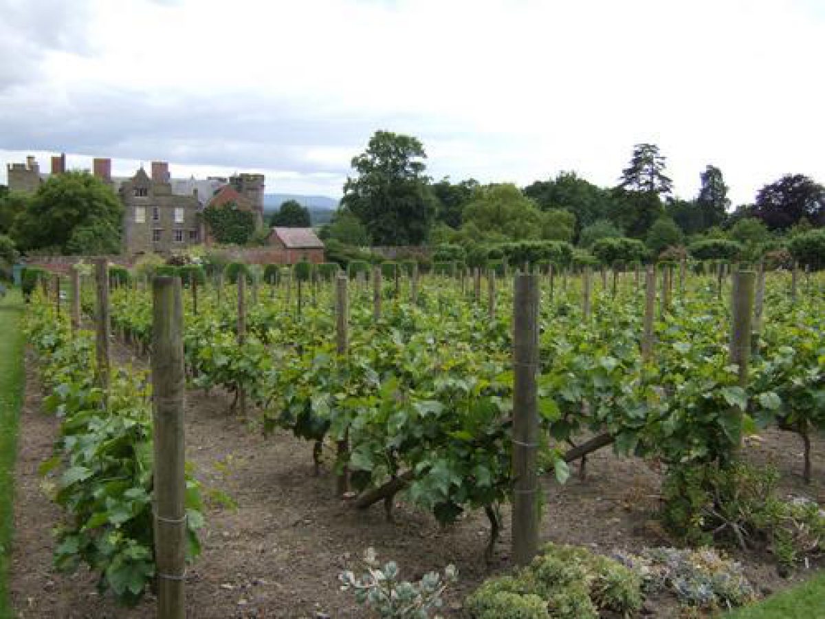
The early C19 brick-walled kitchen garden lies c 50m north of the Castle, and rises gently from south to north. The main compartment is c 120m east/west and c 80m north/south; incorporated in the north wall, which is c 4m tall, is a gardener's house of the mid C19 (post 1839). The interior of the garden is largely given over to lawns and fruit, and a vineyard was established in 1979. At the same time as the North Forecourt Garden was laid out a rose garden was laid out in the southern half of the garden, and Irish Juniper planted either side of the main east/west axial path across the garden. The walled garden was in traditional productive use until at least 1937. By 1957 it was a potato patch. North of the kitchen garden is a large greenhouse, probably of the early C20.
To the north of the track which bounds the slip along the north side of the kitchen garden is a compartment c 200m square, in the late C19 an orchard and still in the late C20 containing a few old apple trees.
REFERENCES
Country Life, 107 (28 April 1950), pp 1206-10; (5 May 1950), pp 1292-6; no 53 (31 December 1996), pp 44-9
P Reid, Burke's and Savills Guide to Country Houses: Volume II, Herefordshire (1980), p 18
K Fretwell et al, Croft Castle Park and Garden Survey 1986-7, (National Trust 1987)
Croft Castle, guidebook, (National Trust 1990)
Maps
OS 6" to 1 mile: Herefordshire sheet 7 SW, 1st edition 1891
OS 25" to 1 mile: Herefordshire sheet 7.13, 2nd edition 1904
Archival items
Estate Papers (Herefordshire Record Office): Estate sale particulars 1923 (AA3/9); Estate records (S33); around 1800 survey of estate (T74).
Description written: 1998
Edited: August 1999
- Visitor Access, Directions & Contacts
Telephone
441568780246Access contact details
The parkland is open throughout the year. The castle is open between March and December. Opening times and days vary seasonally. http://www.nationaltrust.org.uk/place-pages/99/pages/opening-times-calendar
Directions
Five miles north-west of Leominster off the B4362.
Owners
The National Trust
Heelis, Kemble Drive, Swindon
- History
The estate was held by the Croft family from the late 11th century. The deer park is first mentioned about 1655. Surviving avenues appear to date from the late 17th century. The park was landscaped in the 18th century, when the house was remodelled by Thomas Farnolls Pritchard. The kitchen garden dates from the early 19th century.
Recent research suggests the former existence of an elaborate formal garden in the present park.
The following is from the Register of Parks and Gardens of Special Historic Interest. For the most up-to-date Register entry, please visit the The National Heritage List for England (NHLE):
www.historicengland.org.uk/listing/the-list
HISTORIC DEVELOPMENT
The Croft family held Croft from the later 11th century until the mid-18th century, several members gaining national prominence and office. In 1746 the mortgaged property was surrendered by Sir Archer Croft (died 1753), MP, to Richard Knight of Downton who had already acquired some parts of the Croft estate. Knight (died 1765) lived at Croft with his daughter Elizabeth and son-in-law Thomas Johnes, after whose death in 1780 Croft was sold in 1783 by their son Thomas Johnes II, the builder of Hafod, to Somerset Davies, the MP for Ludlow. In 1923 Croft was purchased from Davies' descendants by the trustees of Sir James Croft. The freehold was acquired by the National Trust in 1957.
Period
18th Century (1701 to 1800)
- Associated People
- Features & Designations
Designations
The National Heritage List for England: Register of Parks and Gardens
- Reference: GD1875
- Grade: II*
Style
English Landscape Garden
Features
- Tree Avenue
- Description: Surviving avenues appear to date from the late 17th century.
- Earliest Date:
- Latest Date:
- Garden Terrace
- Kitchen Garden
- Earliest Date:
- Latest Date:
- House (featured building)
- Earliest Date:
- Latest Date:
- Earthwork
- Description: Iron Age hillfort on the northern edge of the park.
- Key Information
Type
Park
Purpose
Ornamental
Principal Building
Domestic / Residential
Period
18th Century (1701 to 1800)
Survival
Extant
Hectares
290
Open to the public
Yes
Civil Parish
Croft and Yarpole
- References
References
- A Survey of Historic Parks and Gardens in Herefordshire
- {English Heritage Register of Parks and Gardens of Special Historic Interest}, (Swindon: English Heritage, 2008) [on CD-ROM] Historic England Register of Parks and Gardens of Special Historic Interest
- Reid, P., {Burke's and Savills Guide to Country Houses, Vol. 2: Herefordshire, Shropshire, Warwickshire, Worcestershire} (London: Burke?s Peerage, 1980), p. 18 Burke's and Savills Guide to Country Houses, Vol 2: Herefordshire, Shropshire, Warwickshire, Worcestershire
- Fretwell, Katie {Croft Castle park and garden survey, 1986-87} (1987) Croft Castle park and garden survey, 1986-87
- Related Documents
-
CLS 1/910
Historic Landscape Survey and Conservation Plan - Digital copy
Nick Owen (Debois Landsdcape Survey Group) - 2004
-
CLS 1/1141
Croft Castle Park and Garden Survey
MSC Community Programme Project - 1986-87
-
CLS 1/910