Introduction
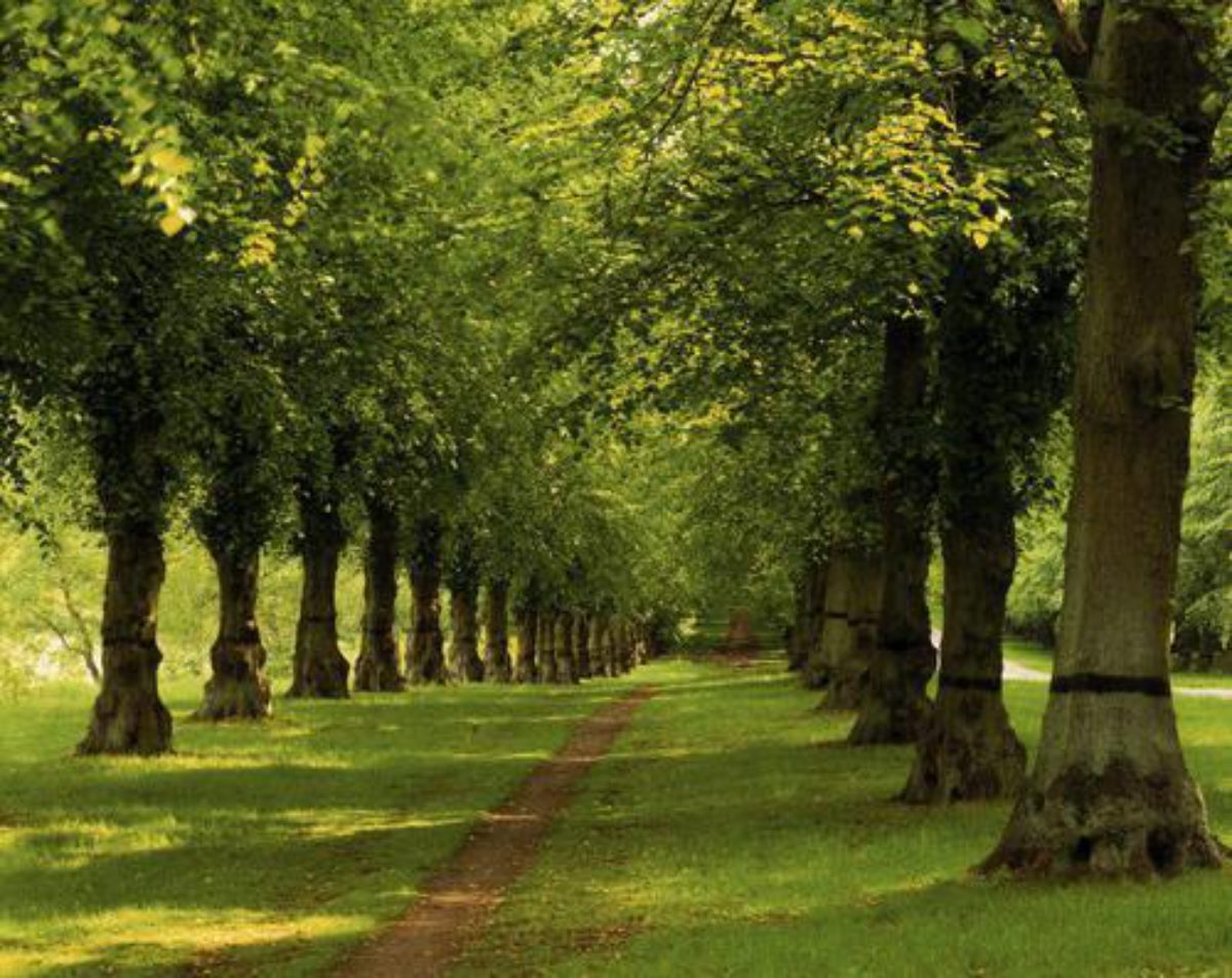
Clumber Park has a landscape park and woodland. Features include a serpentine lake and an avenue of limes. It also has eight hectares of formal and ornamental gardens and a walled garden.
Terrain
The site lies on either side of Clumber Lake and the River Poulter.
The following is from the Register of Parks and Gardens of Special Historic Interest. For the most up-to-date Register entry, please visit the The National Heritage List for England (NHLE):
www.historicengland.org.uk/listing/the-list
An early 18th-century deer park landscaped in the 18th century, possibly with some advice from Lancelot Brown, containing the remnants of early 19th-century terraces possibly by William Sawrey Gilpin, a lakeside pleasure ground by William Eden Nesfield, with 18th-century garden features by Stephen Wright and John Simpson, and a 19th-century garden feature by William Andrews Nesfield.
DESCRIPTION
LOCATION, AREA, BOUNDARIES, LANDFORM, SETTING
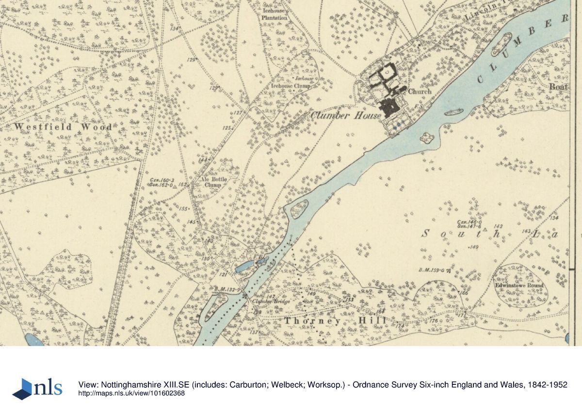
Clumber Park is part of the Dukeries, a term used since the C18 to describe an area of Nottinghamshire south of Worksop and north-east of Mansfield which contained the estates of five dukes. The park is 4.5km south of Worksop and to the east of the village of Carburton, with the estates of Thoresby (qv) and Welbeck Abbey (qv) lying immediately adjacent to the south-east and west respectively. The east boundary is the A614, the east part of the north boundary is the A57, with the other boundaries giving on to woodland and agricultural land. In the north-west corner of the site, the registered site includes the avenue which runs west from the park to Ollerton Road. The site comprises c 1600ha of parkland (guide leaflet) and lies on either side of Clumber Lake and the River Poulter.
ENTRANCES AND APPROACHES
There are seven lodges around the boundaries of the site. From the A614 by Apleyhead Lodge (c 1790s, listed grade I), which takes the form of a tall central archway spanning ornamental iron gates, Limetree Avenue, laid out in the 1840s, runs west, crossing Hardwick Top Road, then passes through woodland and crosses Clumber Lane and Thoresby Road before continuing south-west to join the B6034 at Carburton Lodge (1789, listed grade II). Here a pair of ashlar lodges with slate roofs stand either side of ashlar gate piers with an armorial cartouche dated 1789. Hardwick Top Road crosses the park, joining Manton Lodge, built in the C19 of rendered brick with a pantile roof and standing on the northern boundary, to Normanton Gate (late C17/early C18, listed grade II*) in the south-east corner of the park, where a pair of ornate ashlar gate piers topped by stone urns, relocated from Shireoaks (qv), stand. The road passes through Hardwick village which lies at the east end of the lake. Drayton Road runs west from Drayton Gate (C18, listed grade II*), an ornate ashlar gateway with rusticated stone piers with coats of arms beneath rusticated pediments standing 210m south of Normanton Gate, to Clumber Bridge where it joins South Lodge Drive which continues to South Lodge (1824, listed grade II). Named as Ollerton Lodge on the 1898 OS map, the ashlar building with slate roofs and ornate chimney stacks stands beside a pair of rusticated gate piers topped with stone greyhounds. Immediately north of Clumber Bridge, a road branches off north-east between Ale Bottle Clump and Lady Garden leading to the car park north of Clumber Park Stableyard. At the car park the road bifurcates, the western branch continuing north-west as Clumber Lane to be joined again by the other branch which runs east from the junction, then leads north-west along the west side of the kitchen garden before turning back westwards between the cricket pavilion and the cricket ground. Clumber Lane continues north-west to leave the site at Truman's Lodge (1789, listed grade II), an C18 building of ashlar, brick, and render with plain tiled roofs. Other roads in the centre of the site are Green Lane which runs south of the Lime Avenue linking Clumber Lane with Hardwick Top Road, and Engine Hill which runs west from Hardwick village to join Green Lane.
PRINCIPAL BUILDING
Clumber House lay 100m south of the stable block on the north bank of the lake. The house was created in 1768-78 by Stephen Wright (d 1780) by extending the hunting lodge which was already on the site. He
added square wings at each corner, which contained spacious new apartments. The south front which faced the lake was ornamented by an Ionic colonnade, surmounted by the family arms. Niches on the west entrance front contained white marble statues of the four seasons, and angles of the house were surmounted by sixteen fine vases (guidebook).
The house was altered by Benjamin Dean Wyatt (c 1775-1850) in 1814 and a library added in c 1829 by Sir Robert Smirke (1781-1867). Following a fire in 1879, the central area was rebuilt by Charles Barry the younger (fl 1880s). Another fire broke out in 1912, destroying the upper storey of the north wing but this was subsequently rebuilt. Clumber House was demolished in 1938. The only remaining parts of Clumber House are the Billiard Room, now (1999) the shop, and the Duke's Study (listed grade II) which is now (1999) part of the restaurant.
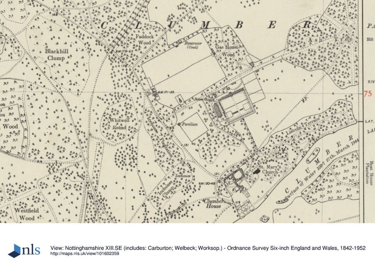
North of the shop is the west stable range (listed grade II) which now (late C20) forms part of the shop and storerooms. The fifteen-bay range has a projecting central bay broken with a pedimented carriage doorway. The range is brick built with ashlar dressings and has a hipped and slate roof with a central clock tower topped with an octagonal cupola. To the north of this range is the stable courtyard (C18 and C19, listed grade II), once the stable yard and vicarage and now converted to offices. The range is brick built with hipped and gabled slate roofs.
Overlooking the lake, east of the stable block and 150m to the north-east of the mansion house site, is the Chapel of St Mary the Virgin. It is the third chapel at Clumber Park: the first was built within the House and the second was designed by Thomas C Hine (1814-99) in 1879 but subsequently demolished. The Chapel was built between 1886 and 1889 by George Frederick Bodley (1827-1907) and Thomas Garner (1839-1906) in the decorated Revival style, of white local stone with red sandstone details.
GARDENS AND PLEASURE GROUNDS
The gardens and pleasure grounds lie on either side of Clumber Lake and extend from Clumber Bridge eastwards to the Boat Dock on the north bank of the lake.To the south of the stable block the outlines remain of the terraces and parterres laid out in the 1820s, possibly by William Sawrey Gilpin (1762-1843). Other possible designers include Sydney Smirke (1799-1877) who was working on the library at Clumber in 1829, William Andrews Nesfield (1793-1881) who worked at Clumber in 1837 on the Battery, and Sir Charles Barry (1795-1860) who produced an unexecuted scheme for the terrace gardens in 1857 (Ray Assocs 1994). Originally there were formal parterres in four quarters on either side of a central path ornamented with urns and other garden statuary as illustrated by Sir Charles Barry's Survey of 1857. The south front of the House overlooked a narrow upper terrace, with central steps leading to a larger lower terrace which terminated in two flights of steps leading to the edge of the lake. A third terrace was situated to the east of the House in front of the conservatory. The terraces can be seen on Sanderson's map of 1835. By 1908, the lower terrace had at its centre a great marble fountain set in a square plat with quarters of flower beds (CL 1908). The terraces were restored by the National Trust in 1974. East of the terraces and 150m south of the stable block is the Battery (1837, listed grade II) designed by W A Nesfield, a rampart jutting into the lake built of coursed rubble enclosing an earth rampart with ashlar coping.
North of the Chapel are the Chapel Grounds (guidebook), planted with ornamental trees and entered by a gate south of the car park. These continue east as the Pleasure Grounds (ibid) and were named as Lincoln Terrace on the OS map of 1899. Lincoln Terrace (c 1860s, listed grade II) is attributed to William Eden Nesfield (1835-88) (Ray Assocs 1994). A path from the Chapel Grounds, 150m north of the lake, passes from west to east through shrubberies of rhododendrons and other large flowering shrubs and ornamental trees such as cedars and conifers. Glimpses of the lake can be seen through the trees. A garden temple (listed grade II), built of ashlar with a hipped lead roof and a Doric distyle portico in c 1784 by John Simpson (fl 1780s) is set in the woodland. Further along an ornamented statue base survives. At the east end of the walk a path leads north-east to a rusticated gateway (c 1800) which leads to a field called Cowpastures and from there through another gate into the parkland. Another path leads south towards the lake to the terrace now (late C20) known as Lincoln Terrace (guidebook). The lakeside Terrace is 200m in length, of gravel with grassed edges, and is planted at intervals with yews. Parallel pairs of stone seats are set at either end of the Terrace. The west pair are apsidal seats decorated with stone birds. Rhododendrons are planted behind the seats and on the north side of the path. From the centre of the Terrace steps lead down to the lake. At the east end of the Terrace is the Boat Dock, an inlet of brick with stone coping built in the 1860s by W E Nesfield for miniature sailing boats. It was restored in the late C20. There was also formerly a boathouse (Ray Assocs 1994).
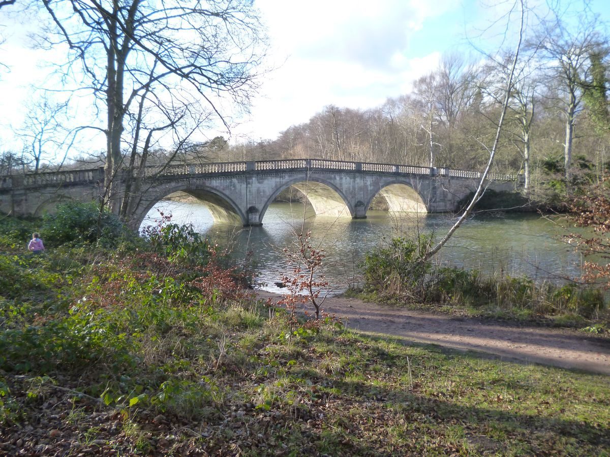
Some 700m south-west of the mansion site and north of the lake is a grotto (1763-7, listed grade II*) approached from a path at the north end of Clumber Bridge. The grotto was designed by Stephen Wright and is built of rock-faced ashlar with a slab roof. Clumber Bridge (c 1763-70, listed grade II*), also designed by Wright, spans Clumber Lake and is built of ashlar with three unequal semicircular arches. There is a curved ornamental cascade on the north side. On the south side of the lake a walk leads east from the Bridge to the Greek temple (c 1765, listed grade II*) set on a hill opposite the mansion site. It is set on a plinth and built of ashlar with a felted roof and a Greek Doric hexastyle portico and was possibly built by Simpson (ibid).
PARK
The parkland is divided by Clumber Lake into two unequal parts. The Lake, 2.5km long and lying south-east of the mansion site, was formed by the damming of the River Poulter, a tributary of the River Maun, in 1774 with improvements made in 1786 by Mr Marson, the then estate manager (Burnett Assocs 1993). It runs south-west/north-east with a north-west/south-east arm at its eastern end. In the south-east corner there is a weir joining it to the River Poulter and 270m east of the weir is a ford. The parkland has conifer boundary plantations on the north and south boundaries while on the east and west boundaries are heathland and deciduous woodland. Most of the rest of the site is made up of broadleaved woodland with heathland to the east. Tenanted houses (some of which are listed grade II) are scattered within the site and also in the settlement of Hardwick village. The brick-built village houses and other buildings were laid out east of the lake for the estate workers in c 1854. Henry Henning, the estate manager/contractor in the 1850s, was involved in the development of the model farm and village (ibid). Lancelot Brown (1716-83) appears to have been paid a small consultation fee for work at Clumber in 1764 but he does not appear to have been commissioned to carry out further work (ibid).
KITCHEN GARDEN
The 2ha kitchen garden (late C18 and late C19, listed grade II) is located 500m to the north of the mansion site. From the mansion site a path leads north-west of the Chapel to the Cedar Avenue which approaches the south gates of the kitchen garden. The garden is also reached from a path which continues east from the road off Clumber Lane and enters the garden in the north-west corner through the glasshouses. The brick-walled kitchen garden is divided by a central brick wall into two, the wall being broken by a gate with stone piers. A caravan site occupies the southern half. The northern half of the garden has vineries all along the north wall with a palm house in the centre. The glasshouses to the east, formerly peach and nectarine houses (Brown, 1930s) are being restored (1999). To the rear of the vineries are garden buildings formerly used as potting sheds, fruit, and vegetable stores and packing rooms (Brown, 1930s) which are now used for interpretation. The north part of the garden is planted with vegetables, flowers, and fruit trees. There are also some fruit trees planted on the south wall of the garden.
REFERENCES
J Throsby, Thoroton's History of Nottinghamshire republished with large additions (1790) [facsimile edn 1972]
A Barry, The Life and Works of Sir Charles Barry (1867)
C Holme, Gardens of England in the Midland and Eastern Counties (1908)
Country Life, 24 (19 September 1908), p 384
Gardener's Magazine, (18 June 1910)
J B Firth, Highways and Byways in Nottinghamshire (1924)
J Anthony, Gardens of Britain 6, (1979)
M Binney and A Hills, Elysian Gardens (1979)
N Pevsner and E Williamson, The Buildings of England: Nottinghamshire (2nd edn 1979)
R Innes-Smith, The Dukeries and Sherwood Forest (1984)
Clumber Park, guidebook, (National Trust 1992)
Clumber Park: An Historic Restoration Plan prepared for the National Trust, (Chris Burnett Associates 1993)
Report of the History of the Pleasure Grounds and Terrace Gardens at Clumber Park, (J Ray Associates 1994)
Clumber Park, map and guide leaflet, (National Trust nd)
Maps
G Sanderson, Twenty Miles Around Mansfield, surveyed 1829-33, published 1835
Sir Charles Barry, Survey of Clumber Park, 1857 (in Ray Assocs 1994)
Annotated plan of Clumber Gardens (kitchen garden) in 1930s, by Mr Brown, a former gardener (NT Collection)
OS 25" to 1 mile
1st edition surveyed 1884
2nd edition published 1899
3rd edition published 1920
Archival Items
Patent Rolls, 9 Anne, 3/29, 5/10 (PRO Index, pp 136, 140)
Description written: October 1999
Register Inspector: CEB
Edited: January 2002
- Visitor Access, Directions & Contacts
Telephone
441909476592Access contact details
The park is open throughout the year. Opening times of other areas vary seasonally.
Owners
The National Trust
PO Box 39, Warrington, WA5 7WD
- History
The following is from the Register of Parks and Gardens of Special Historic Interest. For the most up-to-date Register entry, please visit the The National Heritage List for England (NHLE):
www.historicengland.org.uk/listing/the-list
HISTORIC DEVELOPMENT
Clumber appears in the Domesday Book as Clunbre and was farmed by a Norman tenant as two manors. Both Worksop Priory and Newstead Abbey (see description of this site elsewhere in the Register) held land at Clumber until the Dissolution of the Monasteries in the 1530s. In 1545, Henry VIII granted to Roger and Robert Taverner and their heirs 'the lands at Clumbre, late belonging to Newstede at 11s per annum' (Throsby 1790). John Holles, fourth Earl of Clare, created first Duke of Newcastle in 1694, petitioned Queen Anne in 1709 for 'a licence to make a Park in the Forest of Sherwood in the County of Nottingham for her Majesties Service during her life to contain at Least 3000 Acres of his Own lands of Inheritance' (Patent Rolls); the licence was granted. A hunting lodge was built in the early 18th century, shown on a map of 1738 (guidebook). When John Holles was killed in 1711, Clumber was inherited by his nephew, Thomas Pelham (died 1768), later Thomas Pelham-Holles, who became the first Duke of Newcastle-upon-Tyne in 1715 and first Duke of Newcastle under Lyme in 1756, with a special remainder to the earldom of Lincoln. Clumber had been used as a hunting estate stocked with red deer but by 1761 work had begun on extending the old hunting lodge into Clumber House to designs by Stephen Wright. Thomas Pelham's nephew, Henry Fiennes-Clinton Pelham-Clinton, ninth Earl of Lincoln, became second Duke of Newcastle under Lyme (1720-94) in 1768 and garden buildings and a lake were added over the next twenty years. Thomas Pelham-Clinton, third Duke of Newcastle under Lyme died in 1795, a year after inheriting the title, his son, Henry Pelham Fiennes Pelham-Clinton, becoming fourth Duke of Newcastle under Lyme at the age of ten. Alterations were made to the house in 1814, and in the 1820s and 1830s further changes were made to the house, garden, and park. Henry Pelham Fiennes Pelham-Clinton, a member of Sir Robert Peel's ministry and later Colonial Secretary, became the fifth Duke of Newcastle under Lyme in 1851. The estate village of Hardwick was laid out around 1854 to the east of the lake. By the 1860s, pleasure grounds were laid out and a design for a chapel in the grounds was made by T C Hine. The Duke died in 1864 and was succeeded by his son Henry Pelham Alexander Pelham-Clinton, the sixth Duke of Newcastle under Lyme, a noted sportsman who died in February 1879. Henry Pelham Archibald Douglas Pelham-Clinton inherited as the seventh Duke of Newcastle under Lyme. A fire in March 1879 destroyed parts of the house and the central area was rebuilt by Charles Barry the younger. In 1886, the Chapel of St Mary the Virgin was built. A fire in 1912 burnt out the upper storeys of the north wing but these were subsequently rebuilt. The Duke died in 1928 and his widow closed the House. Henry Francis Hope Pelham-Clinton-Hope, the seventh Duke's brother, became the eighth Duke of Newcastle under Lyme but at his request, the House and grounds passed to his son, Henry Edward Hugh Pelham-Clinton-Hope, the Earl of Lincoln. The estate deteriorated and in 1937 there was a series of sales which included the antique garden ornaments. The House was demolished in 1938, as were the terraces and parterres, and in a demolition sale all the structural elements of the gardens were sold. The Earl of Lincoln planned to build a new house at Clumber but the park was requisitioned by the Army during the Second World War and used as an ammunition dump and testing ground for trench-digging machines. The eighth Duke died in 1941 and the Earl of Lincoln became the ninth Duke of Newcastle under Lyme.
The National Trust purchased Clumber Park in 1945 and it remains (1999) in their care. Since taking over the estate the National Trust have restored many features in the gardens and parkland. Some of the remaining buildings in the centre of the site are used for visitor facilities.
- Associated People
- Features & Designations
Designations
The National Heritage List for England: Register of Parks and Gardens
- Reference: GD2081
- Grade: I
Features
- Ornamental Lake
- Description: A serpentine lake.
- Tree Avenue
- Description: A two-mile avenue of limes which is the longest in Europe.
- Kitchen Garden
- Key Information
Type
Park
Purpose
Ornamental
Survival
Extant
Hectares
1542
Open to the public
Yes
Civil Parish
Carburton
- References
References
- {English Heritage Register of Parks and Gardens of Special Historic Interest}, (Swindon: English Heritage, 2008) [on CD-ROM] Historic England Register of Parks and Gardens of Special Historic Interest
- Holme, C. G., {The Gardens of England in the Midland and Eastern Counties} ([n.p]: Studio, 1908) The Gardens of England in the Midland and Eastern Counties
- Anthony, J., {The Gardens of Britain 6: The East Midlands} (London: Batsford, 1979) The Gardens of Britain 6: The East Midlands
- Pevsner, N. and E. Williamson, {The Buildings of England: Nottinghamshire} (Harmondsworth: Penguin, 1979) The Buildings of England: Nottinghamshire
- Burnett, C; Janette, Ray {Historic Restoration Plan} (1993) Historic Restoration Plan
- Askew Nelson {Clumber Park Parklands Conservation Plan} (2013) Clumber Park Parklands Conservation Plan
- Related Documents
-
CLS 1/447
Parkland Conservation Plan: Maps and Plans - Hard copy
Askew Nelson - 2014
-
CLS 1/513
Parkland Conservation Plan, 1st Draft - Digital copy
Askew Nelson Ltd - 2013
-
CLS 1/514
Core Landscape and Garden History Consolidation Report - Digital copy
Askew Nelson Ltd - 2017
-
CLS 1/515
Core Landscape and Garden History Consolidation Report, Final Draft March 2017, Vol. 1 - Digital copy
Askew Nelson Ltd - 2017
-
CLS 1/516
Section 3 Landscape Development - Digital copy
Askew Nelson Ltd - 2014
-
CLS 1/517
Parkland Conservation Plan, Final Report (January) - Digital copy
Askew Nelson Ltd - 2014
-
CLS 1/565
Parkland Conservation Plan, Vol.1 Final Report - Digital copy
Askew Nelson Ltd. - 2014
-
CLS 1/566
Parkland Conservation Plan, Vol.2 Map and Plans A - Z, Aa - Digital copy
Askew Nelson Ltd. - 2014
-
CLS 1/567
Parkland Conservation Plan, Vol.3 Appendices - Digital copy
Askew Nelson Ltd. - 2014
-
CLS 1/568
Core Landscape and Garden History Consolidation Report - Digital copy
Askew Nelson Ltd. - 2017
-
CLS 1/447