


Introduction
Christchurch Mansion has a picturesque public park of 31 hectares just north of the Old Town Wall. It was formed from the parkland associated with a priory and later house. The land was purchased for the town in 1895. The park is a designated County Wildlife Site is in a Conservation Area, and is Grade 2 on The English Heritage register of historic parks and gardens of special interest. It was the first public park in Ipswich opening in 1895, when the site was purchased for the town.
Terrain
Steeply undulatingwww.historicengland.org.uk/listing/the-list
The site of a former priory, the house was given to the town in 1894 when its surroundings were purchased as a public park. Part of the 16th-century house is built on the site of the priory remains, set in a substantially 19th-century park containing remnants of the 17th- and 18th-century landscape.
DESCRIPTION
LOCATION, AREA, BOUNDARIES, LANDFORM, SETTING
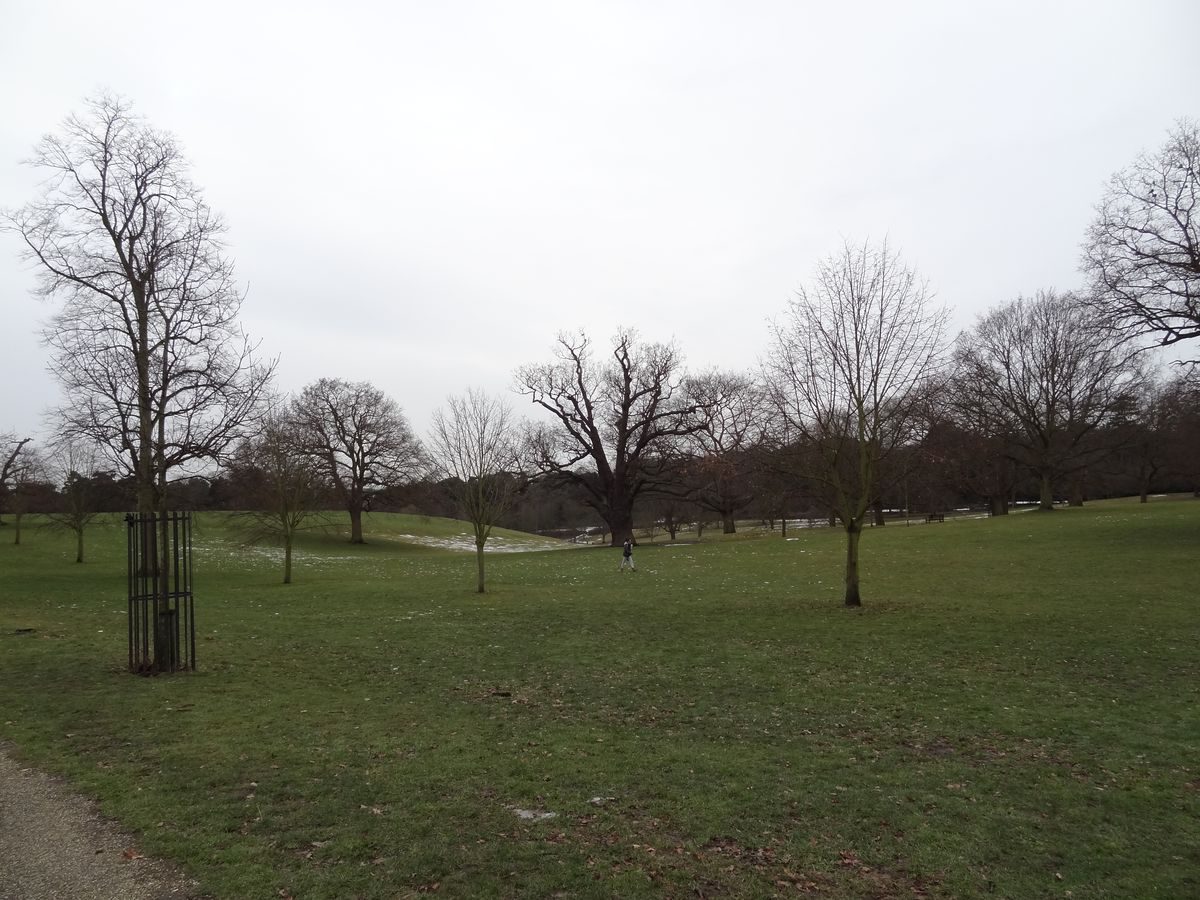
Christchurch Park lies in the centre of the county town of Ipswich, just north of the old town wall. It is generally rectangular in shape, tapering at the south end where the southern boundary formed by Soane Street is of the earliest origins, being shown on Ogilby's map of 1674. Along the northern boundary lies Park Road which was developed for housing in 1894 when the park was acquired by the Borough. The eastern boundary is formed by Bolton Lane to the south, running into Westerfield Road as it goes north, and follows a very similar line to that shown on Kirby's map of 1735. To the west lies Henley Road which was also built up in the C19; opposite the lodge entrance to the Upper Arboretum stands a large, late C19 school building. The park covers c 31ha and falls quite steeply from Park Road in the north to Soane Street in the south. The topography in the central section is dramatic, the many steep undulations being the result of C19 gravel extraction. The extent of the surrounding town, the proximity of buildings along all perimeters and the size of many perimeter trees mean that there are no significant views out of the site.
ENTRANCES AND APPROACHES
The park can be approached from any of its four sides and each has one major lodged entrance. The oldest entrance leads directly to the front of the Mansion from the southern boundary although the existing lodge, gateway and curved wall are by the architect J S Corder and are late C19 century (c 1898, all listed grade II) in origin. This C19 carriage drive approach was remodelled in 1924 to the layout used today (1998). The entrance from Henley Road leads into the Upper Arboretum and is adorned by a small, mid C19 lodge in the rustic 'cottage' style. The Park Road gate piers to the north (listed grade II) are late C19, as are the houses flanking the gates (listed grade II) which were built to look like lodges but have always been part of the private residential development along Park Road. This entrance leads into the park along the tree-lined avenue depicted in Kirby's map of the estate dated 1735 which runs due south towards the back of the Mansion. It is currently (1998) edged by a double avenue consisting of a row of lime at the back with mixed lime, horse chestnut and sweet chestnut of various ages in front. The Westerfield Road entrance has no lodge and leads to a wide drive which runs east/west across the park crossing the north avenue, whilst the Bolton Lane gate enters just north of the Mansion with a small lodge and gate piers built in 1896 (also by the architect J S Corder and listed grade II). There are also a number of small footpath entrances and the wide Bridle Way which stills runs north/south on the west side of the park dividing the Upper and Lower Arboreta.
PRINCIPAL BUILDING
Christchurch Mansion (listed grade I) lies at the southern end of the park, along the Bolton Lane boundary, and is a fine example of a C16 red-brick mansion. The original house, built by Edmund Withypoll between 1548 and 1550, survives in the lower two storeys on the south front and in the east and west wings, all of which are decorated with blue-brick diaper work. Elizabeth I visited Ipswich in 1561 and is said to have stayed at the Mansion, providing a possible reason for an extension to the west wing prior to 1600 (souvenir guide 1989). The upper storey of the Mansion was added by the sixth Viscount Hereford in c 1674 following the fire and the remodelled house is depicted on one of a series of sketches which surround Ogilby's map of the same year. This shows dormer gables in the Flemish style and a porch adorned with balustrade and classical columns. During the C18 the Fonnereau family carried out further remodelling, adding sashed and pedimented windows, and a north-east wing c 1735. Their house is depicted in an engraving dated 1819. Since 1896, after ownership passed to the town, the Mansion has been open as a museum. In 1924, a Tudor merchant's house, saved from demolition at Major's Corner in the town, was moved and reconstructed on the north side of Christchurch Mansion. A further extension to the north was added in 1932 and opened as an art gallery.
GARDENS AND PLEASURE GROUNDS
Little remains of the gardens which surrounded the Mansion when it was in private ownership although the garden area is bounded to the south-east by a brick wall, partly C16, on the line of and incorporating the enclosure wall of the Priory. Forecourts and bowling greens to the south and east are now laid to lawn with a few specimen trees and shrubs. To the rear of the Mansion is a small formal garden (unknown date) of low yew hedges and stone garden furniture.
PARK
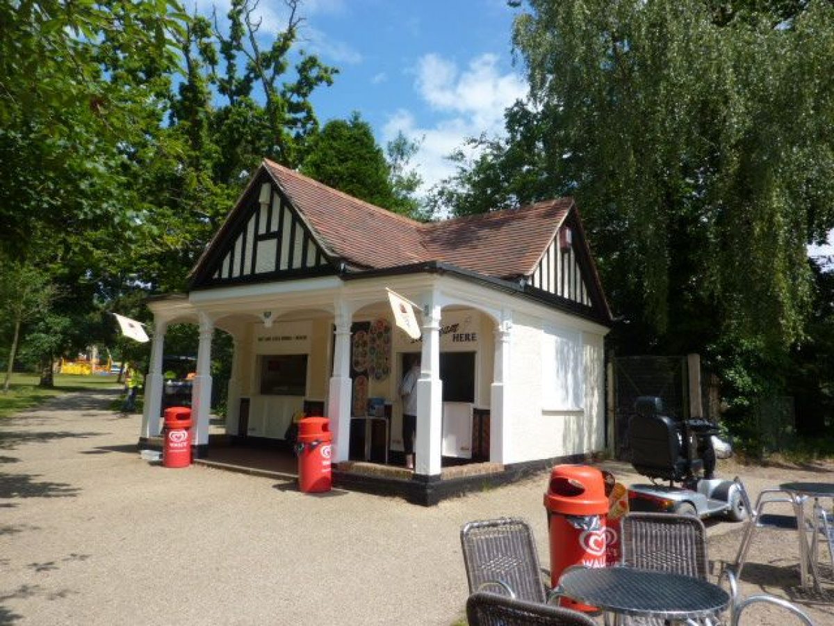
The park can be divided in three distinct character areas: the northern area, the southern area around the Mansion, and the two arboreta to the west. The north has a strong C19 parkland character of open areas of rolling grassland punctuated by groups of trees and scattered individuals. It contains some very old specimens of pollarded sweet chestnut and of oak as well as the double avenue which runs from Park Road to the Mansion. In the centre of the park both the density of planting and severity of topography increase. This area also contains a number of built features including a C19 drinking fountain, a Cabman's Shelter (listed grade II), a late C19 covered seat (now a refreshment kiosk) and a modern children's play area. The Cabman's Shelter was erected in the park in 1895; it is currently (1998) under cover following a fire.
The southern end of the park, close to the Mansion, contains many more features added when the town purchased and developed the park. These include a Martyr's Memorial (listed grade II) by the architect H T Edwards, dated 1903 and situated 50m north of the Mansion; The Cenotaph (listed grade II) by E Adams, erected 170m west of the Mansion in 1923; and the Boer War Memorial (listed grade II) 70m south-west of the Mansion and brought to the park in the early C20. Approximately 30m from the north-west corner of the Mansion lies the Round Pond (dating from at least 1674 when it is depicted by Ogilby) and 750m north-west from this the Wilderness Pond with its island (recorded by Kirby in 1735). These are all that remain of the earlier gardens. All through this part of the park the planting of both trees and shrubs is much more dense and diverse and the area is covered with many criss-crossing paths.
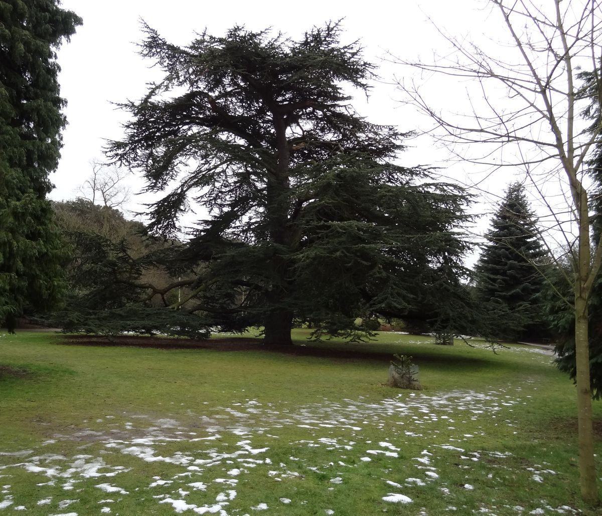
To the west, the Lower Arboretum is taken up mainly by six tennis courts and croquet facilities, surrounded by dense mixed tree and shrub planting, including some mature exotics such as eucalyptus. Along the western shore of Wilderness Pond (c 1735 or earlier) is an area of rockwork with modern planting and paths cut through. A steep bank rises up to the west to the Bridle Way and this is planted with mixed evergreen species, including some large holm oak of particular note. Several crossings over the Bridle Way, a wide, straight, tarmac path bordered by wire fencing, lead into the Upper Arboretum, the southern end of which consists of a flat lawn edged with trees where a mid C19 bandstand/shelter is situated. The centrally situated entrance off Henley Road is laid to lawns cut with bedding and contains an Italianate drinking fountain (listed grade II) given by John Brett and erected in 1862. North of the entrance the Arboretum becomes very undulating, with steeply cut paths bordered by shrubberies leading to a further area of lawn edged with large trees.
KITCHEN GARDEN
Ogilby's map of 1674 shows a kitchen garden lying west of the Soane Street approach to the Mansion, below the main area of decorative parterres. The area existed into the early C18 (Kirby's estate map) but Pennington's map of Ipswich dated 1778 suggests that by then the kitchen garden plot may have become absorbed into the formal garden area and by 1849 the Tithe map shows a 'walled in garden' to the north-east of the Mansion, possibly the site of a replacement kitchen garden. The 1st edition OS 25" map published in 1886 certainly shows the 'walled in garden' crossed with paths and adorned with a well and an area of glass. This however is one of the boundary areas sold off in 1894 to be developed for housing and there remains only one length of wall within the registered boundary which could have its origins in this structure.
REFERENCES
T K Cromwell, Excursions in the county of Suffolk (1819), p 124
White, Directory of Suffolk (1855), p 78
East Suffolk Illustrated (1908), p 272
Christopher Morris, The Journeys of Celia Fiennes (1947), p 144
Country Life, 116 (12 August 1954), p 496; (19 August 1954), p 572; (26 August 1954), p 644; no 19 (12 May 1988), p 136
N Pevsner and E Radcliffe, The Buildings of England: Suffolk (1975), p 298
Eric Sandon, Suffolk Houses: A Study of Domestic Architecture (no date), p 47
Christchurch Mansion and Park, Ipswich: An illustrated souvenir, (Ipswich Borough Council 1989)
Maps [all held in East Suffolk Record Office]
J Ogilby, The borough corporation of Ipswich, 1674
J Kirby, Plan of Christchurch Estate belonging to Tho' Fonnereau surveyed AD1735
I Pennington, A map of the town of Ipswich, 1778
Tithe map of the town of Ipswich, 1849
OS Maps
OS 6" to 1 mile: 1st edition published 1890; 2nd edition published 1905; 3rd edition published 1928
OS 25" to 1 mile: 1st edition published 1886; 2nd edition published 1904; 3rd edition published 1927
Archival items
East Suffolk Record Office holds a collection of illustrations of Christchurch, many of which are postcards (K4/85).
Description written: August 1998
Amended: June 1999
Edited: December 1999
- Visitor Access, Directions & Contacts
Telephone
01473 433512Access contact details
https://www.ipswich.gov.uk/content/park-locations-and-opening-times Telephone 01473 252435
Directions
Use A12 or A14 for Ipswich follow signs for Ipswich town centre. There are a number of car parks, the closest being The Crown Ip1 3JG and Spiral car parks. Please visit https://www.ipswich.gov.uk/services/parking for up-to-date information. The Mansion is ten minutes walk from Ipswich Museum and approximately 20 minutes from the railway station, and five minutes from Tower Ramparts Bus Station in the town centre.
Owners
Ipswich Borough Council
Grafton House, 15-17 Russell Road, Ipswich, IP1 2DE
- History
The following is from the Register of Parks and Gardens of Special Historic Interest. For the most up-to-date Register entry, please visit the The National Heritage List for England (NHLE):
www.historicengland.org.uk/listing/the-list
HISTORIC DEVELOPMENT
The estate of Christchurch was established by the Augustinian Priory of the Holy Trinity in the 12th century (in about 1147) and originally covered 643 acres (about 268 hectares) of farmland. The Priory was suppressed in 1536 and its estates seized by the Crown. In 1545 the manor of Christchurch was sold to Paul Withypoll. His son Edmund inherited in 1547 and began construction of a house on the ruins of the Priory in 1548. The estate remained in the Withypoll family until 1645 when Elizabeth Withypoll inherited. She was married to Leicester Devereux who in 1649 became the sixth Viscount Hereford. Together, Elizabeth and Leicester made many changes, including substantial rebuilding of the house following a fire sometime prior to 1674. The southern section of what is now (1998) the park is depicted on Ogilby's map of Ipswich dated 1674 and this shows the elaborate parterres and formal gardens which surrounded the Mansion at that time. This map also shows the beginning of an avenue running north from the Mansion and a circular pond situated off the north-west corner of the building. Both these features survive in the park today and diarists of the time, most notably Celia Fiennes in 1698 and Sir James Thornhill in 1711 mention the pleasant pleasure ground, the fine fishponds and the bowling greens. In 1732 the tenth Viscount Hereford sold the estate, then comprising 70 acres (about 29 hectares), to Charles Fonnereau, a rich Hamburg merchant. Fonnereau built an underground icehouse, the remains of which survive in the park north of the Mansion, and formed a rectangular green on the forecourt.
The park has a long association with the inhabitants of Ipswich ( diarists writing from the early 18th century onwards record use of the park by the public, in particular Defoe in 1724 and Captain George Elers in 1811. In 1847 the Fonnereau family leased 13 acres (about 5.5 hectares) along the western boundary of the park to be used permanently for public enjoyment. The 13 acres was divided into two by a narrow lane known as the Bridle Way. The Upper Arboretum was leased to Ipswich Corporation as a public pleasure ground for the lower classes and was adorned with flower beds, gravel paths and seats. The Lower Arboretum was leased to a syndicate which opened it to subscribers and to the fee-paying public. In 1892 William Neale Fonnereau put the estate up for sale and a property syndicate purchased the majority of the site for development. A local benefactor however, Felix Thornley Cobbold, purchased the Mansion as a gift to the town on the condition that the Corporation purchased the remainder of the park. Thus only a small section at the southern end of the west boundary, together with a strip along the north boundary, were lost to development. The resulting 28 hectares site was opened to the public in 1895 and the Mansion turned into a museum and art gallery. The Lower Arboretum was purchased by the Borough in 1922 and the Upper Arboretum in 1928. Since that time the boundary of the park has remained the same.
Additional information gleaned from Ipswich Borough Council The site was mentioned in the Domesday Book 1086 and records the Church of Holy Trinity was in possession of 26 acres of land which almost certainly the Anglo-Saxon church that became the site of the Augustinian Priory of the Holy Trinity founded in about 1177. January 20th 1848 A public meeting was organised by Councillor Ransome took place to find a eligible spot for the formation of a park or a place of helpful outdoor recreation for all classes, and in 1853 W.C. Fonnereau, leases 13 acres out to the Ipswich Corporation to develop the Upper Arboretum.
- Features & Designations
Designations
The National Heritage List for England: Register of Parks and Gardens
- Reference: GD1135
- Grade: II
The National Heritage List for England: Listed Building
County Wildlife Site
Plant Environment
Environment
Style
English Landscape Garden
Features
- House (featured building)
- Now A Museum
- Description: The house was substantially re-built in the mid-17th century, where the priory built in 1177 used to stand.
- Earliest Date:
- Icehouse
- Description: Built to the north of the Mansion
- Earliest Date:
- War Memorial
- Description: Boer War Memorial stands between the Round Pond and the Fornnereau Road entrance. Originally it stood on the Cornhill and was moved in 1924 to its present position, near to The Cenotaph. There are others by this sculptor in Cambridge, Bury St Edmunds, but this one is the only one with a bowed head
- Earliest Date:
- Ornamental Fountain
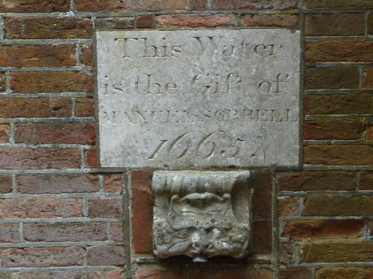
- Description: Italianate drinking fountain in the Upper Arboretum near the Henley Road entrance, donated to the Town by John Brett in 1863, it cost £64.00, restored in 1980 by The Ipswich Society.
- Earliest Date:
- Latest Date:
- Bandstand
- Description: Arts and Crafts Shelter locally known as the Bandstand constructed in 1869 in the Upper Arboretum. Restored in 2005 under the Heritage Lottery Fund Project. It is the site of an annual series of Sunday afternoon concerts organised by the Friends of Christchurch Park in July and August each year
- Earliest Date:
- Pond
- Description: Called the Round or Mirror Pond situated in the area near the Mansion.
- Building
- Description: The Cabman Shelter is moved into the park in 1895 near Bolton Lane from the Cornhill where it had been since 1803. 1995 the shelter was 80% destroyed by fire started by vandals.2006 it was restored and moved to the Westerfield entrance.
- Earliest Date:
- Cenotaph
- Description: Ipswich War Memorial close to the Upper Fonnereau Road entrance designed by Edward Adams ARIBA(1922-1923) The design was highly praised and featured in architectural magazines of its day. The names of 1.481 men and women from Ipswich who fell in World War 1 are on the original Memorial. Over 600 Ipswich people died in service during the second World War and their names were added on new plaques were unveiled 16/05/2004 The town's civic Service of Remembrance is held in front of the Memorial in November every year
- Earliest Date:
- Fishpond
- Description: Wilderness Pond created by Edmund Withypoll and also known as The Dovehouse Pond on Kirby's map 1735. The springs had previously fed 4 separate ponds below a terrace of formal gardens and orchard to the west of the Mansion. In the Middle Ages it was the source of the Town's water supply
- Latest Date:
- Avenue
- Description: Beginning of an ancient avenue shown running north from the Mansion on Ogilvy's map 1674. Alongside the central avenue are some of the oldest trees in the park, they are pollarded Sweet Chestnuts and Oaks, and they are three to four hundred years old.
- Latest Date:
- Sculpture
- Description: Innocence by a Suffolk based artist Linda Thomas in Portland Stone commissioned by Ipswich Borough Council. It is an elegant white marker with a tapered 'eye' to the top right which reflects the pattern of light and shade from the nearby trees. It is a single piece of stone (Bowers Basebed)
- Earliest Date:
- Sculpture
- Description: Triple Mycomorph (fungus Form) Aluminium 1992 commissioned by Tom Gondris originally made in plaster in 1953 and later caste into metal. Tom Gondris chose it to be a memorial to his parents who disappeared on the 'Conitnent' during World War II. Bernard Reynolds was born in Norwich and exhibited with Henry Moore in 1936-1937.
- Earliest Date:
- Building
- Description: 'The Ark' with a teenage area
- War Memorial
- Description: The Martyrs' Memorial which stands near to the Reg Drivers Centre, it was erected to commemorate the burning of 9 protestant martyrs
- Earliest Date:
- Building
- Description: The lodge at the Soane Street entrance
- Avenue
- Description: The Cherry Avenue planted in the Upper Arboretum in 1998 by Ipswich horticultural Society to launch the Christchurch Tree Trail
- Pond
- Description: The Horseshoe Pond established in the 19th century
- Earliest Date:
- Garden Feature
- Description: Peace Garden between the Wilderness pond and the Cenotaph
- Earliest Date:
- Border
- Description: The Wolsey Gallery Garden
- Earliest Date:
- Shrub Feature
- Description: Formal shrub beds to the north of The Upper Arboretum replanted as part of the Heritage Lottery Project, and to the south of the Arts and Crafts shelter
- Earliest Date:
- Rockery
- Description: The rock garden connects The Wilderness Pond to the Lower Arboretum.
- Natural Landscape
- Description: Wild Life Valley in the centre of the Park running from north to south with the Bird Reserve woodland, the Wilderness, Bog and medieval ponds at its southern end. The bird Reserve is mature mixed woodland.
- Key Information
Type
Park
Purpose
Recreational/sport
Plant Environment
Environment
Principal Building
Parks, Gardens And Urban Spaces
Survival
Extant
Hectares
31
Open to the public
Yes
Electoral Ward
St Margaret's
- References
References
- {English Heritage Register of Parks and Gardens of Special Historic Interest}, (Swindon: English Heritage, 2008) [on CD-ROM] Historic England Register of Parks and Gardens of Special Historic Interest
- Pevsner, N. and E. Radcliffe, {The Buildings of England: Suffolk} (Harmondsworth: Penguin, 1975), p. 298 The Buildings of England: Suffolk
- Ipswich Borough Council {A Variety of Landscapes Christchurch Park} A Variety of Landscapes Christchurch Park
- LDA Design {Restoration Plan and Christchurch Park, Ipswich Management and Maintenance Plan 2008 – 2018} (1997) Restoration Plan and Christchurch Park, Ipswich Management and Maintenance Plan 2008 – 2018
Contributors
Diss Design and Fine Arts Society