Introduction
Castle Howard is an extensively landscaped estate which includes gardens, pleasure grounds, a landscape park, woodland and agricultural land. The site has a mixture of formal and naturalistic features.
Terrain
Undulating
Castle Howard is set in over 2,400 hectares of land, comprising agricultural land, woodland, a landscape park and a diverse series of gardens. To the south-west of the house lies the Walled Garden. To the south lies the formal South Parterre, and to the east is Ray Wood, an informal woodland. There are lakes on either side of the house, and there are many statues and several garden buildings throughout the gardens.
Beyond the gardens lies the landscape park which surrounds the house on three sides. Within the landscape park can be found the Mausoleum and the Avenue, which has a collection of ornamental gateways leading into the park. There is also an arboretum, which is called 'Kew' at Castle Howard. It is close to the house but has separate entrance arrangements and was opened in 1999.
The following is from the Register of Parks and Gardens of Special Historic Interest. For the most up-to-date Register entry, please visit The National Heritage List for England (NHLE):
NOTE: This entry is a summary. Because of the complexity of this site, the standard Register entry format would convey neither an adequate description nor a satisfactory account of the development of the landscape. The user is advised to consult the references given for more detailed accounts. Many Listed Buildings exist within the site, not all of which have been here referred to. Descriptions of these are to be found in the List of Buildings of Special Architectural or Historic Interest produced by the Department of Culture, Media and Sport.
Location, Area, Boundaries, Landform and Setting
Castle Howard lies c 20 km north-east of York in a rural and agricultural setting. The c 1240 ha site is on high rolling land and the boundaries are fenced and walled.
Entrances and Approaches
The principal entrance to the site is from a beech and lime avenue c 6 km in length which runs approximately north/south on the west side of the Castle extending both north and south of the park. At the south end The Monument (F P Cockerell 1869-70, listed grade II*) is a tall stone column, and c 1.4 km to the north of this the pedimented Carmire Gate (Hawksmoor c 1720, listed grade I), is flanked by crenellated walls. Aligned with the Carmire Gate and visible from it at the top of a hill, the Gatehouse or Pyramid Gate (Vanbrugh 1719 with flanking wings of 1756 by Sir Thomas Robinson, listed grade I) has a central arch capped by a pyramid and is flanked by walls extending to the east and west along the top of the slope. The walls are punctuated by a succession of towers of different designs (walls and towers by Vanbrugh c 1723, listed grade I). The drive continues through the Gatehouse's central arched opening to The Obelisk (Vanbrugh 1714, listed grade I) from which an avenue leads east to the Castle. The main avenue continues northwards terminating at Sheep Walk. This route was laid out by Vanbrugh and completed c 1723. From the south it is one of the grandest approaches to a country house in England with the succession of structures contributing to a mounting sense of anticipation as the visitor draws closer to the Castle. The approach from the north is chiefly notable for outstanding views of the Castle overlooking the Great Lake.
Principal Building
Castle Howard (listed grade I) lies on an elevated site close to the centre of the park and enjoys long-distance views from the north and south fronts. It was designed by Sir John Vanbrugh (with assistance from Nicholas Hawksmoor) and was his first country house commission. Charles Howard initially consulted William Talman but rejected his designs and instead adopted Vanbrugh's proposals, though these were not fully executed and the west wing is the work of Sir Thomas Robinson executed in the years following 1756. Castle Howard is a private residence (1998).
The stables (listed grade I) lie c 300 m south-west of the Castle. They were designed by John Carr in 1781-4 for the fifth Earl of Carlisle.
Gardens and Pleasure Grounds
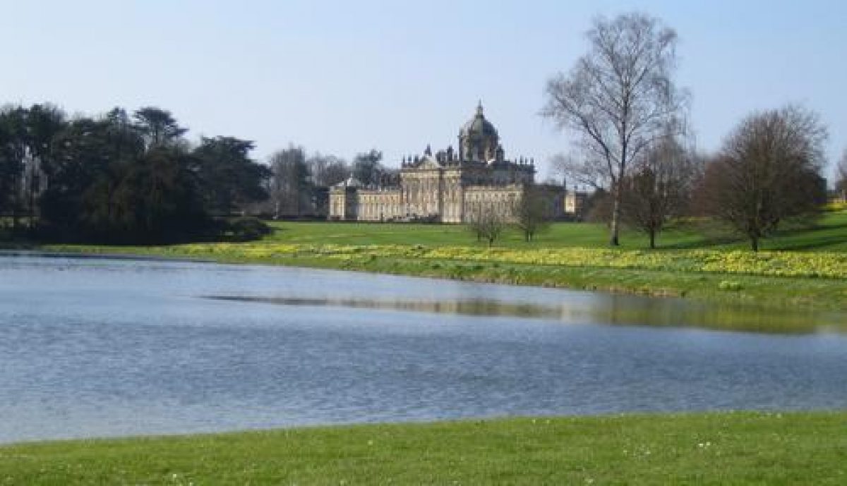
On the north side of the Castle there are extensive views over parkland and the Great Lake, which was constructed 1795-9. Broad Walk is one of the principal axial routes running east/west along the south front of the Castle, continuing alongside the kitchen garden and terminating at the west end with a clairvoie called Victoria Gates (early and mid C18, listed grade I). The vista on the east side is terminated by an urn (C18, listed grade II) in Ray Wood. The South Parterre is aligned with the south front of the Castle and at its southern edge there is a ha-ha. Views to the south are dominated by a large folly called The Pyramid (Hawksmoor 1728, listed grade I).
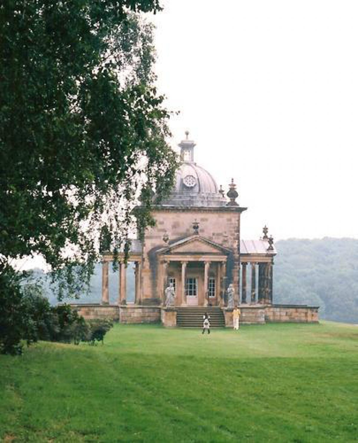
South-east of the Castle a terraced walk, called the Temple Terrace (formerly Henderskelfe's village street) runs south-east and below this, to the south, South Lake dates from the 1720s. The east end of the Lake is connected to New River by Nesfield's cascade, basin and waterfall. Temple Terrace continues along the southern edge of Ray Wood and leads to the Temple of the Four Winds (Vanbrugh 1724-8, listed grade I), an imposing porticoed pavilion with a central dome, which stands at the head of a valley and has views to the south and east of the bridge over New River (attrib. Daniel Garret c 1740, listed grade I). Also visible on a bluff c 1.2 km east of the Castle, The Mausoleum (Hawksmoor and others 1729-40, listed grade I), is a massive domed monument more than 30 m in height encircled by twenty columns. This structure is one of Hawksmoor's best-known and most striking provincial works and is a prominent landmark.
North-east of the Castle is Ray Wood, for which London had proposed a geometrical pattern of rides. Instead a system of serpentine paths was instituted but these fell into disuse later in the C18. The wood has an important collection of Rhododendrons which was retained when the trees were felled in the 1940s, and when the trees were replanted in the 1960s, and a system of winding pathways was reintroduced. On the east side of Ray Wood there is a walkway between the Temple of the Four Winds and the site of Hawksmoor's Temple of Venus which collapsed in the 1940s.
The park to the south and east is sheltered by woodland, and in Pretty Wood, in the south-east corner of the site, a pyramid (Hawksmoor 1720s, listed grade I) and a sculpture called the Four Faces (Hawksmoor 1720s, listed grade I) are linked by a system of rides.
Ray Wood
Ray Wood is a reconstructed wilderness with serpentine walkways cutting through a replanted ancient wood. The replanting has included a collection of rhododendrons as well as hybrids, shrubs and trees from all over the world. Part of the wood is for private use only and is used mostly for shooting.
Kitchen Garden
The kitchen garden lies c 100 m south-west of the Castle. The walls and gateways (listed grade I) were designed by Vanbrugh and extended to the west in the mid C18.
Maps [all held in a private collection]
- Estate map, 1694
- Estate map, 1727
- N Hawksmoor, Plan of Henderskelfe, no date, around 1700 [See also Whistler 1954]
- OS Map
- OS 6" to 1 mile: 3rd edition published 1912
Description written: September 1998
Amended: October 2004
Edited: October 1999
- Visitor Access, Directions & Contacts
Telephone
01653 648333Website
https://www.castlehoward.co.ukAccess contact details
For detailed visitor information visit the Castle Howard website.
Directions
Castle Howard is located 15 miles north east of York, just off the A64 in the direction of Malton.
If travelling from the north turn off the A1 onto the A61 to Thirsk and then take the A170 to Helmsley. Turn onto the B1257 just before Helmsley and follow the brown signs.
From the south turn off the A1M at junction 45 onto the A64 and follow east to York. Once past York follow the brown signs.
Castle Howard can also be reached by public transport by going to Malton which is 5 miles away.
- History
18th Century
Although much of Castle Howard can be attributed to the 18th century it is actually made up of various phases of development.
In the first phase, between about 1700 and 1750 Ray Wood, the Temple Terrace and the South Parterre were created.
The Wilderness (now lost) which lay beyond the parterre was also constructed during this time. It was a symmetrical maze, possibly made from clipped hedges, and can be seen in the third volume of Vitruvius Britannicus dating to 1725 (Saumarez Smith, 1997: II-III).
This first phase of construction also saw the building of the Walled Garden. Work began in 1703, and by the 1750s the garden had doubled in size.
The next phase of development took place from about 1720 to 1800 and involved the creation of the two lakes. The New River and the bridge over it were also constructed during this time.
During the mid-19th century William Andrews Nesfield was employed to extend the south waterways. He created the Prince of Wales and the Atlas Fountain and also the design of the South Parterre. This design lasted less than 50 years, being replaced in the 1890s with a simplified and less costly design.
Castle Howard was opened to the public in 1952 and since then work in the grounds has concentrated largely on restoration. Garden buildings and statues have been restored, as well as Nesfield's waterways. Grounds staff have also removed some of the late-19th-century planting to open up views into the surrounding parkland.
The following is from the Register of Parks and Gardens of Special Historic Interest. For the most up-to-date Register entry, please visit The National Heritage List for England (NHLE):
NOTE: This entry is a summary. Because of the complexity of this site, the standard Register entry format would convey neither an adequate description nor a satisfactory account of the development of the landscape. The user is advised to consult the references given below for more detailed accounts. Many Listed Buildings exist within the site, not all of which have been here referred to. Descriptions of these are to be found in the List of Buildings of Special Architectural or Historic Interest produced by the Department of Culture, Media and Sport.
16th - 18th Century
The estate was acquired by the Howard family in 1571 when it was the site of Henderskelfe Castle and village. Henderskelfe was described by John Leland in 1540 who estimated that the park was '4 miles yn cumpace, and hath much fair young wood yn it' (quoted in Antiqs J 1979). Charles Howard, third Earl of Carlisle rejected a scheme of around 1698 by George London (died 1714) with canals, avenues and circular lawns. Vanbrugh was consulted and visited the site in 1699, continuing to work on it until his death in 1726. Works to Vanbrugh's designs continued after his death, probably supervised by his assistant Nicholas Hawksmoor (1661-1736) who was responsible for the design of some of the park structures.
Later 18th-century works included the creation of the Great Lake on the north side of the Castle. In 1850 the south parterre was remodelled by W A Nesfield (1793-1881) and the Atlas Fountain (Nesfield with figures by J Thomas, listed grade I) was installed. Nesfield also undertook works to the South Lake and designed a cascade (listed grade II) at its east end. Nesfield's parterre proved expensive to maintain and it was replaced by the ninth Countess in the early 1890s with the present (1998) grass terrace and yew hedges. At the same time the banks of the South Lake were remodelled to give less rigid outlines.
Horace Walpole is one of the better known of the many commentators on Castle Howard and following a visit he described it in 1772 as presenting 'the grandest scenes of rural magnificence' which allowed him to see 'at one view... a palace, a town, a fortified city, temples on high places, woods worthy of being each a metropolis of the Druids, the noblest lawn on earth fenced by half the horizon, and a mausoleum that would tempt one to be buried alive' (quoted in Jellicoe et al 1986).
20th Century
The estate is in private ownership (1998).
- Associated People
- Features & Designations
Designations
Area of Outstanding Natural Beauty
The National Heritage List for England: Register of Parks and Gardens
- Reference: GD2061
- Grade: I
Ancient Replanted Woodland
Features
- Temple
- Description: The Temple of the Four Winds was originally known as the Temple of Diana because of the association of a statue of Diana in Ray Wood.It was designed by Vanbrugh and is located at the eastern end of the Temple Terrace at the south east corner of Raywood.The temple consists of a cube with dome and four porticoes. Four female figures are located on the steps of the temple.Beneath the temple is a cellar which was used for the storage and preparation of food.
- Earliest Date:
- Latest Date:
- Mausoleum
- Description: The Mausoleum was designed by Nicholas Hawksmoor but it has significant alterations by Lord Morpeth, Sir Thomas Robinson and Lord Burlington.It is located nearly a mile from the house towards the south east.It stands 90 feet(27.4 metres) high. It is a cylindrical structure supported by a colonnade of 20 pillars and is surrounded by a circular bastion wall. Steps lead up to the domed chapel.Inside the chapel the ceiling rises 70 feet(21.3 metres) in the air and has carved decoration which includes cherubim's heads and acanthus leaves. Eight Corinthian columns surround the interior wall.Beneath the chapel is the crypt which contains 63 loculi for receiving coffins.The Mausoleum is not open to the public.
- Earliest Date:
- Latest Date:
- Octagonal Temple
- Description: The Temple of Venus was designed by Hawksmoor and is located a quarter of a mile to the north of the Temple of the Four Winds.Only the pedestal survives and this was much grassed over when surveying took place in 2001.The original design was an open rotunda of eight Tuscan columns under an octagonal entablature and dome. In the centre stood a statue of Venus which is now located in the Walled Garden.In 1931 the temple was already very ruinous. When Ray Wood was clear felled in the early 1940s a tree was felled on top of it so that it would collapse because it was feared to be unsafe.
- Earliest Date:
- Latest Date:
- Pyramid
- Description: The Pyramid was designed by Hawksmoor.It is located east of the Gatehouse (Pyramid Gate) and is within full view of the house.It is a squat pyramid in rough grass. Inside is a colossal bust of Lord William Howard, the founder of the Carlisle branch of the Howard family and their fortune.It is not open to the public.
- Earliest Date:
- Latest Date:
- Statue
- Description: The Statue of Apollo is located at the southern end of the Lime Walk but originally lay within Ray Wood.Apollo stands on a large pedestal which has carvings of villages, rocks, mountains, and waterfalls on it.
- Earliest Date:
- Latest Date:
- Great House (featured building)
- Description: A stone built house originally designed by Sir John Vanbrugh but with later alterations and additions by Sir Thomas Robinson.The house can be described as having two main styles, baroque and palladian.
- Earliest Date:
- Latest Date:
- Obelisk
- Description: The Obelisk was designed by Vanbrugh and is located at the head of the drive to the west of the house.It was built to commemorate the Duke of Marlborough's victories and the completion of the house. It stands 100 feet(30.48 metres) high and has two inscriptions on it. The first, in Latin, commemorates the Duke of Marlborough. The second, in English, is a statement of posterity for the aspirations of Lord Carlisle and his family.
- Earliest Date:
- Latest Date:
- Gatehouse
- Description: The Gatehouse or Pyramid Gate was built by Vanbrugh.It is located along the Avenue west of the house and grounds. The Gatehouse is Egyptian or Roman in style and is topped by a pyramid. The wings to the Gatehouse were added by Sir Thomas Robinson in 1756-8 and the building became an Inn.Mock fortification walls extend either side of the Gatehouse for a half a mile in both directions. Each tower has a different design and is built in the gothic or medieval style.
- Earliest Date:
- Latest Date:
- Gate
- Description: The Carrmire Gate was built in the 1720s by Nicholas Hawksmoor.It is located along the Avenue west of the house and grounds.It is a rubble built arch with a crenellated wall and two turrets. The whole structure was designed in the gothic or medieval style.
- Earliest Date:
- Latest Date:
- Avenue
- Description: The Avenue is located west of the house and grounds.It is a five mile straight road running due north.As visitors approach Castle Howard the road deliberately rises and falls providing teasing glimpses of the house.
- Earliest Date:
- Latest Date:
- Key Information
Type
Estate
Purpose
Ornamental
Principal Building
Domestic / Residential
Survival
Extant
Hectares
1240
Open to the public
Yes
Civil Parish
Henderskelfe
- References
References
- Saumarez Smith, Charles, {The Building of Castle Howard} (London: Pimlico, 1997) The Building of Castle Howard
- Conran, Sebastian, {Castle Howard} ([Yorkshire]: Castle Howard Estate Ltd, 1997) Castle Howard
- Ibbotson, H, {The Illustrated Hand-Book to Castle Howard, the Yorkshire Seat of the Right hon. The Earl of Carlisle} (Malton: Henry Smithson, 1851) The Illustrated Hand-Book to Castle Howard, the Yorkshire Seat of the Right hon. The Earl of Carlisle
- Ridgeway, Christopher and Williams, Robert (Eds) {Sir John Vanbrugh and Landscape Architecture in Baroque England 1690-1730} (Stroud: Sutton, 2000) Sir John Vanbrugh and Landscape Architecture in Baroque England 1690-1730
- Jellicoe, Sir G. et al (eds), {The Oxford Companion to Gardens} (Oxford: Oxford University Press, 1986), pp. 98-9 The Oxford Companion to Gardens
- Holme, C. G., {The Gardens of England in the Midland and Eastern Counties} ([n.p]: Studio, 1908), plates 25-8 The Gardens of England in the Midland and Eastern Counties
- Campbell C., (1725), pp 5-6 Vitruvius Britannicus. 3
- pp 144, 147 Society of Gentlemen, England displayed 2
- Young A., (1771), pp 60-2 Six Month's Tour Through North of England
- Watts W., (1778) Plate 3 The Seats of the Nobility and Gentry, in a Collection of the most interesting & picturesque Views
- Manners J H (Duke of Rutland), pp 101-7 Journal of a Tour to the Northern Parts of Great Britain
- Brooke E A., plates 33-4 The Gardens of England
- Gardeners Chronicle, pp 321-2 Gardeners' Chronicle 2
- (1 October 1904), pp 486-95; 20 (6 October 1906), pp 492-4; 61 (4 June 1927), pp 884-93; 62 (6 August 1927), pp 200-8; (13 August 1927), pp 230-7; 156 (12 September 1974), p 694; 173 (17 March 1983), p 636; no 2 (11 January 1990), pp 62-5 Country Life, 16
- Jekyll, Gertrude., (1918) pp 241, 244 Garden Ornament
- Lady Rockley, pp 180-1 Historic Gardens of England
- Whistler L., plates 19-20 The Imagination of Vanbrugh and his Fellow Artists
- de Beer E S., (ed), pp 593-4 The Diary of John Evelyn 4
- Downes K., pp 47-51, 173-4, 190-206 Hawksmoor
- Binney M and Hills A., pp 15, 37 Elysian Gardens
- (part 2), (1979), pp 358-60 Antiqs J 58
- Summerson J., pp 280-3 Architecture in Britain 1530-1830 (revised and enlarged 1983),
- Beard G., pp 31-7, 83-93 The Work of John Vanbrugh
- Related Documents