Introduction
Howsham Hall has a well-documented landscape park. Features include a gothicised water mill.
Terrain
The site slopes gently down to the river, where it forms a plateau on which the Hall stands.The following is from the Register of Parks and Gardens of Special Historic Interest. For the most up-to-date Register entry, please visit The National Heritage List for England (NHLE):
This is a mid to late C18 landscape park for a house of 1610, created by the Cholmley family and with which Lancelot Brown was associated c 1770, which partly covers the archaeological remains of a post-medieval village and of an early C18 formal garden laid out by the then owner of Howsham Hall, Sir John Wentworth.
Location, Area, Boundaries, Landform and Setting
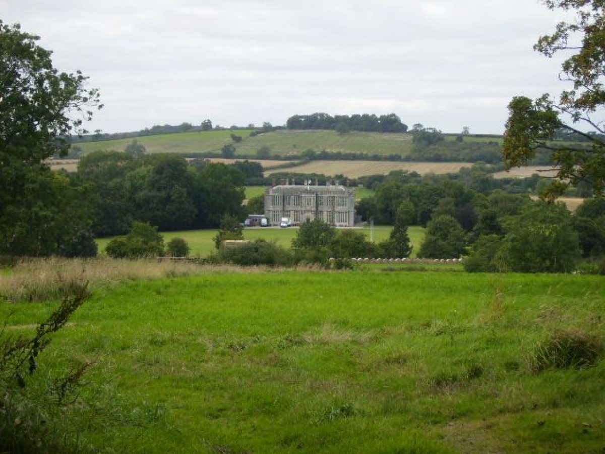
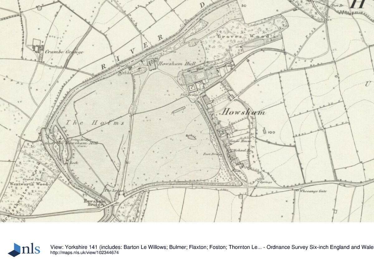
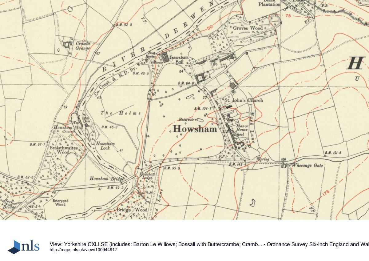
Howsham Hall is situated on the south bank of the River Derwent, c 13 km south of Kirkham Abbey which stands further upstream. The site of c 45 ha slopes gently down to the river, where it forms a plateau on which the Hall stands. The River Derwent curves along the north and west boundary of the site. To the south the area is bounded by Low Lane, and to the east by the village of Howsham. The setting of Howsham Hall to the north and south consists of agricultural land and to the east and west of ancient woodland: Braisthwaites Wood and Bridge Wood to the west and Howsham Wood a short distance to the east.
The parkland to the south offers fine views to the Hall and the hills in the background north of the River Derwent. During the late C18 landscape improvements there were further important views created to and from various features in the park, now (1999) mostly obscured by vegetation, such as to and from the gothic water mill, Howsham Bridge, the sham boathouse, and the stable block.
Entrances and Approaches
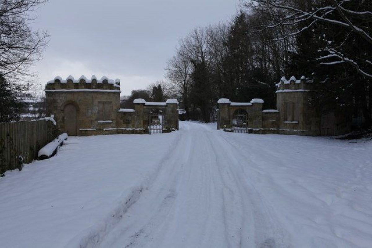
The main entrance is via Howsham Lodge in the south-west corner of the site. The entrance has two pairs of gate piers each flanked by six-sided lodges (listed grade II) which echo the Jacobean design of the Hall. The entrance gives access to the main drive which runs in a northerly direction to the south front of the Hall.
The second approach is via the road which runs in a northerly direction through the village of Howsham along the eastern boundary. The road enters the site c 200 m south-east of the Hall and runs past the stable block on the east up to the south front of the Hall. The line of this road possibly dates from the early C18 when it ran through the centre of the former village of Howsham to the Hall, as indicated on the 1703 plan.
The site can also be approached from the River Derwent by boat, the Derwent having been a well-known transport route in North Yorkshire for many centuries.
Principal Building
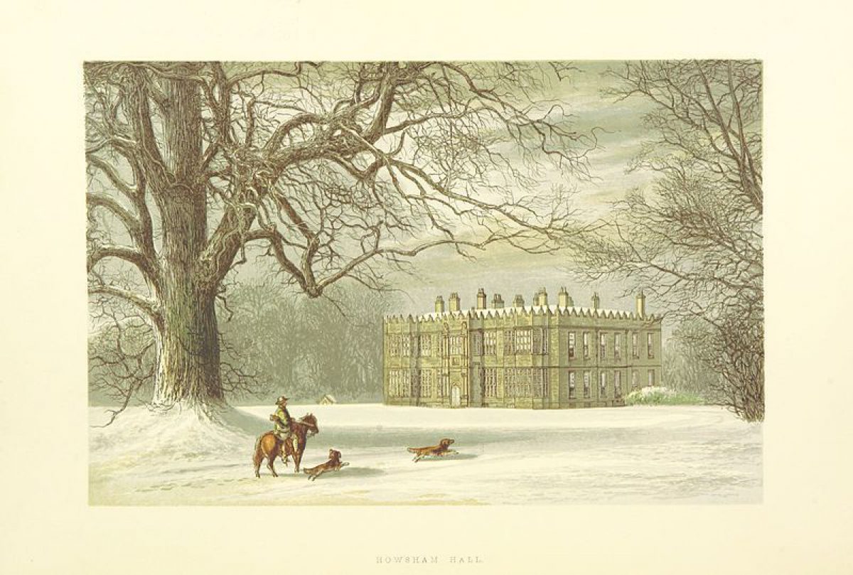
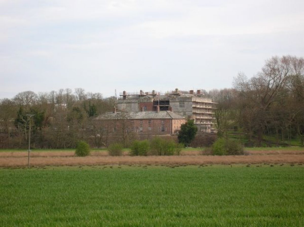
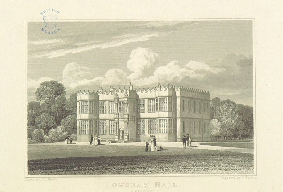
Howsham Hall (listed grade I) stands in the northern part of the site, c 30 m south of the River Derwent. The south front was built c 1610 by Sir William Bamburgh, whose arms are impaled over the entrance. The two-storey façade has full-height canted bays to either end with a central frontispiece. The frontispiece has two paired Ionic columns and Corinthian columns with a central window. The south front is dominated by fenestration: the central frontispiece is flanked by two windows on either side and by two large fenestrated canted bays.
The east side of the Hall, remodelled by Sir John Wentworth in the early C18, shows his crest and the date 1709 on the lead downpipes. This façade has six bays with large sash windows, with a C19 extension to the north. The west side of the Hall is irregular and has mullion and transom windows. Attached to this side of the Hall is a temporary one-storey pre-fabricated building, introduced recently (1999).
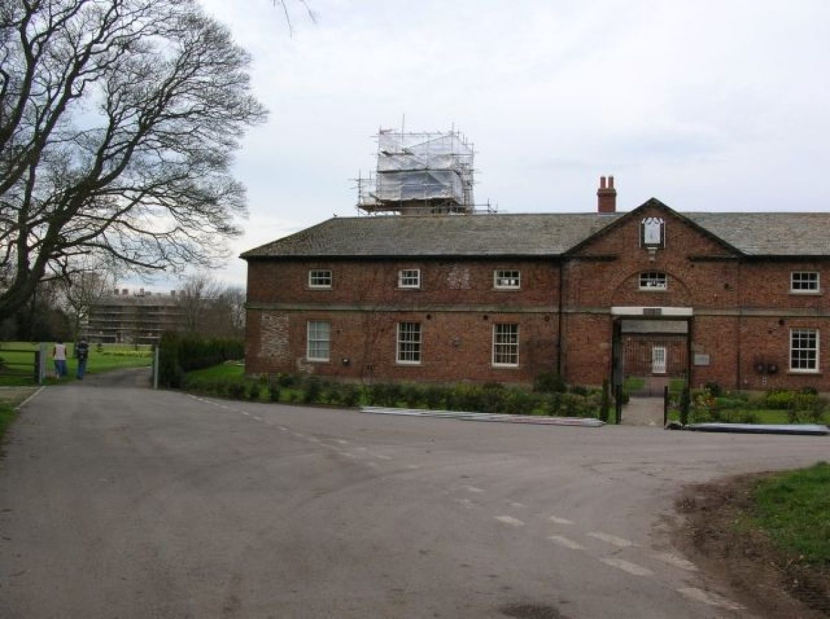
The stable block of c 1775 (attributed to John Carr, listed grade II), with to its east Home Farm, a late C18 converted barn, stands c 100 m south-east of the Hall. The stable block is built of brick and has a hipped roof of Westmorland slate. The west front has a central block housing the main entrance, now (1999) blocked, and has on its pyramidical roof a clock tower with open lantern and cupola.
Gardens and Pleasure Grounds
The land lying to the east of the east drive, between the Hall and the stable block, forms a terrace, with to its north a ha-ha that runs parallel to the river. This creates a strip of land lying c 1 m below the terrace. The terrace is now partly grassed over and partly in use as agricultural land. This area may contain the archaeological remains of the early C18 formal gardens laid out by Sir John Wentworth, as shown on Booth's painting of 1718. These gardens were removed during the late C18 landscape improvements and partly replaced by a wood with informal paths, called Groves Wood (see plan of 1792). The latter may have incorporated a former double avenue that formed part of the early C18 formal garden. Groves Wood is no longer (1999) extant.
The land immediately south of the Hall is grassed and used by the school as playing fields (1999). Further to the south, on a line west from the stable block, runs a ha-ha or ditch built of natural stone. To the north it is lined by trees, probably planted in the C19, partly obscuring views from the park to the Hall and back. In the early C18, as indicated on the painting of Howsham Hall of 1718, the area immediately south of the Hall was walled, forming a courtyard.
Kitchen Garden
During the 1960s, after the estate had fallen into decline, the kitchen garden walls to the north of the stable block were demolished. Part of the west wall, including its former entrance adjacent to the stable block, and the east wall, attached to Home Farm, still stand (1999).
Park
The parkland to the south of the Hall contains some fine mature parkland trees, possibly planted in the late C18 and C19. Some 10 m to the west of the Hall is a small area planted with trees and shrubs, probably dating from the mid to late C19. In this area, c 15 m west of the Hall, are the remains of an icehouse. West of this is a small formal orchard in which stand the remains of a brick boathouse, depicted for the first time on the OS map of 1912. Immediately to the east are the remains of a late C18 sham boathouse (listed grade II). The latter, now (1999) ruinous, is a two-storey building with, on its south front, a blocked round-arched door flanked by a pair of blocked two-light mullions.
The south and east boundary of the park are lined with a thin belt of mixed trees, which screen the village and the road to the south. As indicated on the OS map of 1856, a path (now, 1999, no longer there) leading to Howsham Bridge at the south-west corner of the site used to run through this belt. The eastern part of the park, to the west of the village road, shows a series of earthworks which are the remains of the post-medieval village of Howsham, demolished as part of the late C18 landscape improvements. In this area there is also a small pond, now partly silted up, which is marked as a reservoir on the OS map of 1912. To its west stands a vaulted brick structure (of unknown function), possibly C19 in date, perhaps built after the village was demolished in the late C18.
The western part of the site, called The Holms, is a disused water meadow. Several drains and ditches run through the site, one of which links up with the ha-ha in the parkland to the east. A public footpath runs from Howsham Bridge north-westwards to a small island situated in the River Derwent, in the west corner of the site. On the island stand the remains of Howsham Mill. The island and the mill, now much overgrown, can be reached by the remains of the locks which were used to cross the canal. The Holms was already in use as a water meadow in the early C18: an island with a mill and a small canal are indicated on the 1703 plan. During the late C18 landscape improvements however The Holms, although retained as a water meadow, became part of the designed landscape. The island and the canal (the latter called The Cut on the OS map of 1856), were remodelled, as was Howsham Mill, which was given an ornamental gothic elevation to become an important feature in the landscape. Subsequently, views to and from the mill on the island were created between the Hall, the late C18 sham boathouse west of the Hall, and the cupola on the stable block. These views are now partly obscured by vegetation and trees, probably planted in the C19. In the late C19 the mill was extended to its west and new locks were probably installed. Formerly the island could be accessed from The Holms by a swing bridge (OS 1856), now (1999) no longer there.
Maps
- Joseph Dickinson, A map of the Manor of Howsham, 1703 (ZCG M1/3 MIC 1343/22), (North Yorkshire County Record Office)
- Samual and Isaac Milbourn, A plan of the township of Howsham, 1758 (ZCG M1/9 MIC 1343/83), (North Yorkshire County Record Office)
- A map of the Manor at Howsham, 1776 (ZCG (W) MIC 1343/99), (North Yorkshire County Record Office)
- Plan of the Manor at Howsham, 1792 (ZCG (W) MIC 1343/208), (North Yorkshire County Record Office)
- OS 6'' to 1 mile: 1st edition published 1856
- OS 25'' to 1 mile: 2nd edition published 1912
Illustrations
- J Booth, painting, Howsham, One of the Seats of the Hon Sir John Wentworth Bart in the East Riding of the County of York, 1718 (ZCG M1/6 MIC 1343/225), (North Yorkshire County Record Office)
Description written: April 1999 Amended: May 1999
Register Inspector: FDM
Edited: November 2004
- Visitor Access, Directions & Contacts
- History
The following is from the Register of Parks and Gardens of Special Historic Interest. For the most up-to-date Register entry, please visit The National Heritage List for England (NHLE):
16th Century
The lands of Howsham belonged to nearby Kirkham Abbey until the Dissolution, and the present house was possibly built with stone removed from the abbey and carried down the River Derwent. Kirkham and thus Howsham were granted by Edward VI to Thomas, Earl of Rutland, from whose grandson, Edward, the manor of Howsham was bought by Thomas Bamburgh in 1573. William Bamburgh, who succeeded in 1593, gave Howsham Hall its present form, possibly preserving parts of an earlier house to which he added a Jacobean stone front. From the time of Thomas Bamburgh's purchase in 1573 the estate never changed hands by sale until 1948, passing instead through daughters to the successive families of Wentworth, Cholmley, Fane, Grimes, and Strickland.
18th Century
The historical development of the landscape is marked by two distinct phases: the first took place during the early C18, the second in the mid to late C18. During the C19 and C20 the parkland remained largely unaltered. Sir John Wentworth, Lord of Howsham between 1689 and 1720, was responsible for the remodelling of the east façade of the Hall. He subsequently laid out a series of enclosed formal gardens and an avenue to this side of the Hall, as illustrated on Joseph Dickinson's plan of 1703 and on a painting of 1718 by John Booth.
By 1758 considerable changes had taken place to the Hall and landscape, possibly begun by Nathaniel Cholmley who inherited Howsham in 1755. As shown on the plan of 1776, the formal gardens had been removed and the grounds extended immediately to the south. This extension involved the demolition of several houses and was the first stage in the reduction of the village of Howsham which then comprised of two rows of houses on either side of a green, built upon at its northern end, as shown on the plan of 1703. Cholmley improved the interior of the Hall with the advice of John Carr (1723-1807) and his assistant Thomas Atkinson c 1770. Around that time Lancelot Brown (1716-83) was consulted and his accounts state he was paid fifty guineas, which suggests that he may have produced a set of plans. The late C18 landscape improvements, completed by 1776, included the creation of a landscape park to the south of the Hall and the remodelling of the existing water mill and The Holms to the west. They also included the building of a stable block with adjacent kitchen garden and barns, a new drive with a bridge over the River Derwent, and the building of a pair of lodges and gate piers, a ha-ha, an ornamental boathouse, and an icehouse.
20th Century
In 1948 the then owner, Miss Willoughby, married Captain H Strickland and Howsham and its contents were sold. It subsequently changed hands at least twice and in 1954 it was bought after it had remained vacant and fallen into disrepair. During the late 1960s the then owner, not being able to find a use for the Hall, was eventually given permission to demolish it, but the Hall was bought and since 1958 has been occupied by a boys' preparatory school. The stable block is currently (1999) owned by a private company and there are plans to extend it to the north for use as a conference centre. The remaining registered land is in mixed private ownership.
- Associated People
- Features & Designations
Designations
The National Heritage List for England: Register of Parks and Gardens
- Reference: GD4182
- Grade: II
Features
- House (featured building)
- Earliest Date:
- River
- Description: Howsham Hall is situated on the south bank of the River Derwent.
- Garden Building
- Description: Gothick water mill.
- Stable Block
- Description: The stable block of c 1775 (attributed to John Carr, listed grade II)
- Ha-ha
- Lodge
- Description: Howsham Lodge
- Key Information
Type
Park
Purpose
Ornamental
Principal Building
Domestic / Residential
Survival
Extant
Hectares
45
Civil Parish
Howsham
- References
References
- {English Heritage Register of Parks and Gardens of Special Historic Interest}, (Swindon: English Heritage, 2008) [on CD-ROM] Historic England Register of Parks and Gardens of Special Historic Interest
- Stroud, D., {Capability Brown} (London: Faber, 1975), p. 215 Capability Brown
- Views of the Seats 5
- Views of the seats, mansions, castles II
- F O Morris, Series of picturesque views I, (1866-80), p 13 A Series of Picturesque Views of the Seats of the Noblemen and Gentlemen of Great Britain and Ireland
- Some Historic Mansions of Yorkshire
- Country Life, 17
- Victoria History of the County of Yorkshire I
- pp 494-6 The Buildings of England: Yorkshire, York and the East Riding
- pp 42-3 Landscaped Parks and Gardens of East Yorkshire, 1700 - 1830
- Yorkshire Field Notes 1998/9
- A Country House Reprieved
Contributors
Val Hepworth