Introduction
Buscot Park is a landscape park with formal gardens covering around 40 hectares, including an early 20th-century Italianate water garden and walled kitchen gardens.
Terrain
The land is gently hilly, within a rural setting, with the house sited on a hilltop with panoramic views northwards towards the River Thames lying 1km to the north.www.historicengland.org.uk/listing/the-list
A late 18th-century country house surrounded by gardens, and late 18th- and 19th-century landscape park, with an early 20th-century formal water garden by Harold Peto connecting the house with one of the lakes.
DESCRIPTION
LOCATION, AREA, BOUNDARIES, LANDFORM, SETTING
Buscot lies 5km west of Faringdon, running along the south side of the A417 Lechlade to Faringdon road, in the south-west corner of Oxfordshire. The c 115ha site is bounded to the north by the A417 Lechlade Road, along much of which runs a rubble stone wall backed by a belt of trees, and on the other sides by agricultural land and woodland. The land is gently hilly, within a rural setting, with the house sited on a hilltop with panoramic views northwards towards the River Thames lying 1km to the north.
ENTRANCES AND APPROACHES
The main approach, off the A417, enters the park at the north-west corner, 600m north-west of Buscot House, passing between the West Lodges (listed grade II), set slightly back off the road and at an angle to it. The westernmost of the two two-storey, ashlar lodges (c 1780) was remodelled 1934-5 by Geddes Hyslop, when a second lodge was built to the east to form a matching pair, the two being in style a 1930s adaptation of late Georgian neo-Classicism. The lodges are linked by iron railings on low stone walls flanking two stone gate piers supporting 1930s iron gates. The drive curves south-east through the park, flanked by narrow belts of trees, crossing the Little Lake (1779-83) via a brick bridge (probably Harold Peto c 1904-13, listed grade II) with a small single arch, carrying stone-balustraded parapets and large curving stone consoles at each corner. The tree-lined drive continues through the park, with a spur 75m north-west of the House giving access to the north front of the stables, and a further spur east, 50m west of the House, rising up to the west pavilion and office court. A view of the west front is obtained through a central archway in the west pavilion. The drive curves round the west pavilion and into the main forecourt, entering 50m west of the House between two tall stone gate piers with ball finials (re-used from Peto's c 1913 forecourt layout by Geddes Hyslop c 1935, listed grade II), and running diagonally across the forecourt and up a small rise adjacent to the south front to the semicircular gravel sweep and imposing flight of stone steps leading up to the front door.
The forecourt extends 100m from the south front, enclosing a largely level lawn. A broad central grass terrace is raised on an axis with the south front. The forecourt is bounded largely by a stone ha-ha, rising into a balustrade at the two points of entry to west and east. The south boundary is defined by stone balustrading above the ha-ha, flanking two central ashlar piers with ball finials supporting a decorative iron screen between them (Geddes Hyslop c 1935, the whole perimeter listed grade II), giving views south across the parkland in the open valley to the woodland closing the view beyond.
A second, east drive enters the estate 2.5km east of the House past the Faringdon Lodges (probably Sir Ernest George c 1895, listed grade II), two single-storey, neo-Georgian, square ashlar buildings linked by four stone gate piers with iron gates between them, the whole set slightly back off the road. The drive runs south-west and then west through Eaton Wood, across open fields to the east edge of Canada Wood, where it is carried across a stream by a bridge (probably Peto 1904-13), emerging at a drive linking Heckford Lodge to the north with Oldfield Farm to the south. This eastern section of the drive was created from a former woodland track by the first Lord Faringdon along with the construction of the Faringdon Lodges. From Canada Wood the drive continues westwards, up through parkland to Cannonhill Wood, where, 450m from the House, it turns north-west, running dramatically straight down a steep valley side and up the other side to the forecourt, entering it between two tall stone gate piers flanked by stone screen walls topped by balustrades (Peto c 1913, relocated Geddes Hyslop c 1935), arriving at the steps on the south front. The western section of the east drive was laid out by Robert Campbell c 1860s. The approach to the mansion via this drive was straightened to its present form by Geddes Hyslop c 1935. The course of the drive formerly lay further to the west, following a curving course up to the south front (OS 1876).
A further drive enters at the north-east corner of the park, 900m east of the House, at Heckford Lodge, a late C18, two-storey stone lodge. The entrance to the drive is marked by the remaining one of two tall, stone gate piers (c 1890s). The drive runs due south, crossing the bridge (C18, listed grade II) over the outfall from the main lake to the west some 50m south of the Lodge. This three-arched bridge has its ornamental face to the west acting as an eyecatcher from the north-east terrace of the House across the lake. This face consists of ashlar and squared rubble stone. The east face is of coarser stone, also containing brick elements, overlooking further informal ponds and water features within the woodland to the east. These features, which are now rather overgrown (1997), date from the late C18 (estate plan, 1798) and follow the course of a stream southwards through Canada Wood. The drive continues south, along the west side of Canada Wood, crossing the east drive 400m south of Heckford Lodge before continuing to Oldfield Farm south of the park.
Middle Lodge (C18, shown as Mud House on Rocque's 1761 plan), stands adjacent to the A417, 450m north-east of the House, half way between the West Lodges and Heckford Lodge. The two-storey stone lodge, with a curved north front, is set back off the road and screened by part of the stone boundary wall, with a gateway in the wall flanked by two low stone gate piers.
PRINCIPAL BUILDING
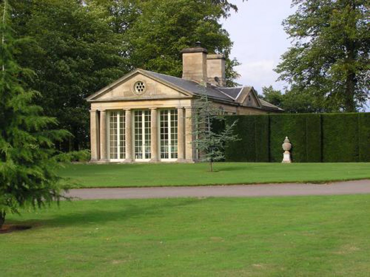
Buscot House (James Darley 1779-83; enlarged Ernest George 1890s; remodelled Geddes Hyslop 1934-6, listed grade II*) stands towards the west side of the park, on the top of a low hill, with long views to the north beyond the park across the Oxfordshire countryside. The rectangular central block is flanked by two pavilions (Geddes Hyslop 1935, listed grade II) to west (containing staff quarters) and east (containing a squash court and small theatre), linked to the House by formal, rectangular open spaces. That to the east is largely taken up by a swimming pool, and that to the west by the office court giving access to the back door. The pavilions are ornamented with Tuscan pedimented and pillared porticoes on the fronts which overlook the garden terrace to the north and forecourt to the south. The House is entered from the south via a broad flight of steps flanked by bronze centaurs, giving access on the piano nobile. There is no access from the north side of the House to the north garden terrace.
The dressed stone stable block (1781, listed grade II) stands below the House, 150m from the west front, with a central carriage arch giving access from the north side. Above this is a clock tower with arched ringing stage and cupola above. The south side is of brick and forms the north side of the series of kitchen garden walls.
GARDENS AND PLEASURE GROUNDS
The garden lies to the north and east of the House. The north terrace, reached from the House via a set of stone steps at the north-east corner of the east pavilion, lies against the north front of the House, enclosed by stone retaining walls (the terrace laid out by Robert Campbell c 1860s, with work by Geddes Hyslop c 1935, walls listed grade II). It is laid largely to lawn divided into two terraces, the north boundary being raised above the parkland beyond, which falls away to the north. A circular stone pond (Geddes Hyslop c 1935, listed grade II) lies on the lower, northern lawn, sunk slightly below the main level of the terrace and separated from the park below by the stone retaining wall. It is reached from the upper lawn adjacent to the House by two sets of low stone steps to west and east. The north front is flanked by clipped yew hedges, separating the areas between the House and pavilions from the north terrace.
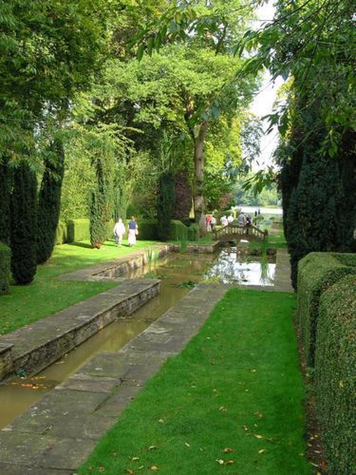
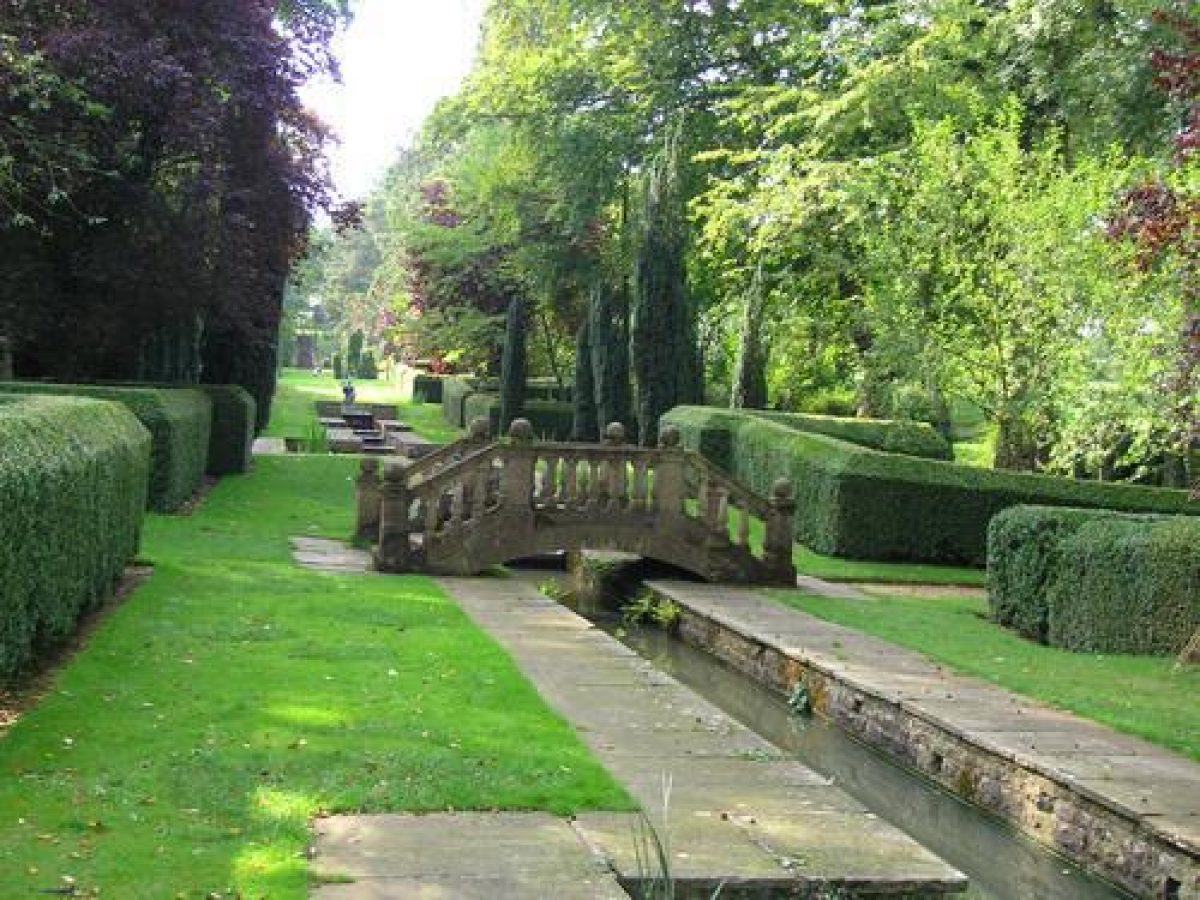
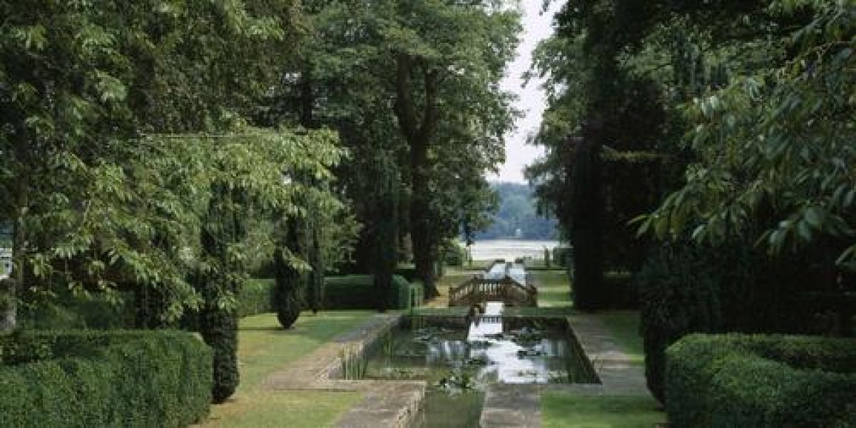
A curved set of stone steps at the centre of the east boundary of the north terrace leads down to informal lawns and woodland, through which a straight cut is driven east towards the west side of the lake, 300m east of the House. Peto's narrow, 250m long axis, running down the shallow hillside, links the House and lake, with a small, white-painted rotunda acting as an eyecatcher at the far, east side of the lake, in line with the avenue and the east pavilion. Peto's formal, 80m long Italianate water garden runs down to the bottom of the axis, drawing the eye east towards the lake from the east pavilion. The water garden consists of a chain of stairways, paths, basins and canals, with fountains, small cascades and a hump-backed balustraded bridge, carried through the woodland and enclosed by clipped box hedges.
During the late C19 the wooded area through which Peto's features were constructed consisted of pleasure grounds laid out by Robert Campbell (c 1860s), linking the east front of the House with the lake. At the west end, by the House, a semicircular formal area lay adjacent to the north terrace. A path led east through an area of open lawn studded with trees (largely conifers) down to a wooded area by the lake edge. The water garden and rotunda were laid out for the first Lord Faringdon by Harold Peto in two phases (c 1904 and 1911-13), initially following Robert Campbell's straight arboretum walk (c 1904), and later (1911-13) extended through C18 woodland to link up with the lake. It appears that a pergola preceding the water features to the west was constructed (Colvin and Moggridge 1998), and removed in the mid C20. The ornamental area flanking the water garden was progressively extended by the second Lord Faringdon.
The water garden avenue is the northernmost of three rides laid out in the shape of a goose-foot by the second Lord Faringdon, leading out through former parkland, now wooded, towards the park to the east. Various features have been constructed within this woodland during the mid to late C20, including the Swinging Garden, and the Sunken Garden, beyond which is the Top Circle, a hedged circular lawn at the top of a rise with views north to the water garden and across to the lake and park.
PARK
The park is largely surrounded by woodland, with open areas of pasture and arable, some containing single trees and clumps. Lying in the north-east corner, the c 8ha lake contains several small islands on its south side, and a further bridge on the west side. The lake was constructed during the late C18 enlargement of the park by Loveden Loveden. A formal double avenue runs north from the ha-ha on the north terrace towards the north boundary, framing views from the House and north terrace down the hillside towards the country beyond.
The park was laid out in two phases during the C18 (early 1780s and mid 1790s). It was further developed by Robert Campbell (1860s) who drew in the park boundaries to the west and south, constructing a reservoir in former parkland on Bury Hill, west of the present park boundary (outside the area here registered). At the same time he consolidated and extended the park to the east. In the late C19, up to at least c 1900 (OS 1876, 1900), the park lay in two large enclosures to north and south of the House, separated by the pleasure grounds linking the east front of the House with the lake to the east. A large part of the area south of the pleasure grounds has been taken in from the park in the C20 to form the southern part of the gardens.
KITCHEN GARDEN
The kitchen garden lies 150m south-west of the House, straddling a small valley running south from the stable block, and split into concentric sections by brick walls (C18, listed grade II). The main, north entrance from the centre of the stable block opens upon a former frame and glasshouse yard and is aligned with a central entrance into the north wall of the octagonal central garden to the south, now (1997) known as the Four Seasons Garden. This area is formally laid out, containing two central gravel paths arranged in cruciform pattern, flanked by pleached hop hornbeam (Ostrya carpinifolia) and Judas tree (Cercis siliquastrum) hedges, at the centre of which is a circular stone pond (C18) with stone balustrading (late C20). The interior is largely laid to lawn in panels between the hedges, with mixed borders around the perimeter and an adjacent path. Four entrances corresponding to the points of the compass are flanked by tall stone gate piers, those piers to the north and south being C18, those to the east and west being erected (c 1930s) by the second Lord Faringdon. The east entrance is closed by an iron grille and gate with overthrow leading to a set of stone steps, broken by intervening level grass paths and flanked by clipped yew hedges, running east up the hillside towards the forecourt, giving access to the House. The path crossing the octagonal garden from east to west runs down to a central pond lying at the lowest point of the kitchen garden. The path then rises west up a steep hillside towards a small gazebo (moved from the 1860s pleasure grounds east of the House, mid/late C20) set into mature woodland running along the ridge at the top. The south and west gateways give access to the outer sections of the garden, encircling the south and west sides of the nucleus. The south area is laid to lawn, that to the west contains a young orchard.
Until the mid C19 the outer brick walls entirely encircled the internal octagonal garden, creating a concentric arrangement of walls, but a section to the east has been lost and the previously enclosed ground laid to lawn. The removal of sections of the wall was begun by Robert Campbell (1860s; OS 1876). The kitchen garden has been laid out by the present (third) Lord Faringdon in the late C20, with planting designs by Peter Coats (Melon Ground) and Tim Rees (Four Seasons Garden).
REFERENCES
Country Life, 40 (21 October 1916), pp 490-7; 87 (18 May 1940), pp 502-7
Victoria History of the County of Berkshire 4, (1924), pp 512-14
N Pevsner and J Sherwood, The Buildings of England: Berkshire (1974), pp 108-9
S Lacey, Gardens of the National Trust (1996), pp 59-61
The Faringdon Collection, guidebook, (Trustees of the Faringdon Collection 1998)
Buscot Park, Review of Landscape History and Management, (Colvin and Moggridge 1998)
Maps
J Rocque, A topographical survey of the county of Berks ..., 1761
Mr Church, Estate Plan, 1798 (private collection)
C and J Greenwood, Map of the county of Berks ..., surveyed 1822-3, published 1824
Buscot Tithe map, 1839 (Berkshire County Record Office)
S Mills, Conveyance Plan, 1860 (Berkshire County Record Office)
OS 6" to 1 mile: 1st edition published 1881-2; 2nd edition published 1900
OS 25" to 1 mile: 1st edition published 1876; 2nd edition published 1900
Description written: January 1998
Amended: March 1999; April 1999
Edited: January 2000
- Visitor Access, Directions & Contacts
Telephone
01367 240932Access contact details
tel: 01 367 240786 http://www.nationaltrust.org.uk/place-pages/59/pages/opening-times-calendar Limited opening during summer only (April to September), when the grounds are open every day from 2pm - 6pm. For house and tea-room, see website.
Directions
Between Lechlade and Faringdon on the A417. There are bus services from Swindon and Faringdon, with a walk of over 2 miles.
Owners
The National Trust
Heelis, Kemble Drive, SwindonThe Faringdon Collection Trust
- History
The following is from the Register of Parks and Gardens of Special Historic Interest. For the most up-to-date Register entry, please visit the The National Heritage List for England (NHLE):
www.historicengland.org.uk/listing/the-list
HISTORIC DEVELOPMENT
Buscot Manor was bought by Walter Loveden from the Stonor family in 1557. The Lovedens continued in ownership through the 17th and 18th centuries until the mid-19th century. James Darley built the present house on a new site in 1779-83, and laid out the first phase of the park at the same time for Edward Loveden Townsend (around 1749-1822; from 1772 Edward Loveden Loveden). Loveden's second phase of park works was completed by 1798 (Colvin and Moggridge 1998).
In 1859 the estate was acquired by Robert Campbell, who attempted to turn Buscot into the most highly industrialised farm in the country, and the estate was subsequently sold to the financier and politician Alexander Henderson (1850-1934, later first Lord Faringdon) in 1889. During the 1890s Lord Faringdon employed Ernest George to remodel the house. Harold Peto was employed from 1904 to 1913 to remodel the approaches and pleasure grounds, the work being carried out in two phases. Peto designed the Italianate water garden around 1904, incorporating features on the site of Robert Campbell's 1860s pleasure ground, extending the water garden eastwards to the lake and remodelling the forecourt around 1911-13. In 1948 Ernest Cook bought the estate and leased the house and garden back to the second Lord Faringdon, subsequently bequeathing the estate to the National Trust in 1956, in whose ownership it remains (1998).
Period
- 18th Century (1701 to 1800)
- Late 18th Century (1767 to 1800)
- Associated People
- Features & Designations
Designations
The National Heritage List for England: Register of Parks and Gardens
- Reference: GD2091
- Grade: II*
Style
English Landscape Garden
Features
- Lawn
- Garden Terrace
- Lake
- Basin
- Cascade
- Ornamental Canal
- Pool
- Fountain
- Rill
- Ornamental Bridge
- Temple
- Herm
- House (featured building)
- Earliest Date:
- Latest Date:
- Stream
- Outdoor Swimming Pool
- Reservoir
- Basin
- Water Garden
- Description: Italianate
- Key Information
Type
Park
Purpose
Ornamental
Principal Building
Domestic / Residential
Period
18th Century (1701 to 1800)
Survival
Extant
Hectares
115
Open to the public
Yes
Civil Parish
Buscot
- References
References
- {English Heritage Register of Parks and Gardens of Special Historic Interest}, (Swindon: English Heritage, 2008) [on CD-ROM] Historic England Register of Parks and Gardens of Special Historic Interest
- Lacey, S., {Gardens of the National Trust} (London: The National Trust, 1996), pp. 59-61 Gardens of the National Trust (1996)
- Pevsner, N., {The Buildings of England: Berkshire} (Harmondsworth: Penguin, 1966), pp. 108-9 The Buildings of England: Berkshire
- Page, W. and Ditchfield, P.H. {Victoria County History: Berkshire, Volume 4} ([n.p.]: [n.pub.], 1924), pp. 512-4 Victoria County History: Berkshire, Volume 4
- Colvin and Moggridge (Hoare, Simon) {Buscot Park (Summer House proposal). Review of landscape history and management} (1998) Buscot Park (Summer House proposal). Review of landscape history and management
- Related Documents
-
CLS 1/562
Parkland Management Plan - Digital copy
Askew Nelson Ltd. - 2018
-
CLS 1/563
Parkland Management Plan, Vol.2 Maps and Plans A-R - Digital copy
Askew Nelson Ltd. - 2018
-
CLS 1/564
Parkland Management Plan: Appendices A - M - Digital copy
Askew Nelson Ltd. - 2018
-
CLS 1/500
Parkland Management Plan, 1st Draft - Hard copy
Askew Nelson Ltd - 2017
-
CLS 1/562