Introduction
Broughton Hall has an associated landscape park and pleasure grounds. Other features include an Italianate terraced garden designed by William Andrews Nesfield and a walled garden restored in the late-20th century and redesigned by Dan Pearson.
Terrain
The site is on rolling land through which the Broughton Beck runs approximately east/west across the northern part of the site.This registered site is part of a larger 1200 hectare estate financed in part by the establishment of a business park in the late 20th century. Businesses (51 in total in 2008) occupy converted farm buildings. The estate now employs over 600 people. As part of the development the 19th-century walled garden was rebuilt and an award-winning pavilion constructed within it designed by Sir Michael Hopkins, which serves as a restaurant and meeting space. The landscape around it was designed by Dan Pearson and features undulating landforms, yew hedges and generous areas of tall perennial planting with paths flowing through them.
The following is from the Register of Parks and Gardens of Special Historic Interest. For the most up-to-date Register entry, please visit The National Heritage List for England (NHLE):
Formal gardens by William Andrews Nesfield of 1855-7 which are considered to be one of the best surviving examples of his work (Jellicoe et al 1986) and pleasure grounds partially remodelled by Nesfield which incorporate elements of an early to mid-19th-century or earlier layout with early 18th-century origins. The park has 18th-century or earlier origins and it was probably landscaped in the early 19th century.
Location, Area, Boundaries, Landform and Setting
Broughton Hall lies c 5 km west of Skipton in a rural and agricultural setting. The c 75ha site is on rolling land through which the Broughton Beck runs approximately east/west across the northern part of the site and the Denbers Dyke runs almost parallel to it through the southern part of the site. The A59 forms most of the northern boundary, a disused railway line runs along the southern boundary and fences divide the remaining boundaries from agricultural land.
Entrances and Approaches
There are two main entrances, both on the north side of the site. The principal entrance is from a lane which runs south from the A59 over Broughton Bridge (mid C19, listed grade II) to a stone screen wall with cast-iron railings with a central entrance and a lodge (Andrews & Delaunay c 1855, screen and lodge listed grade II). A drive runs south-east to a set of secondary stone gate piers and gates before running up to the north side of the Hall. This route, but not the lodge, is shown on the 1st edition OS map surveyed 1848/50. The bridge appears on a county map of 1771. Another entrance with screen walls and a lodge (early C19, listed grade II) lies at the north-east tip of the site on the A59. A drive runs south-west to the edge of the pleasure grounds where there is another gate and a lodge (early C19, perhaps by George Webster, listed grade II ) called Middle Lodge, from which the drive continues through the wooded pleasure grounds to the gardens where it emerges, flanked by yews, into the gardens and on to the north side of the Hall. This route and both lodges are shown on the 1848-50 OS map.
Principal Building
Broughton Hall (listed grade I) is sited on a platform on the south side of the valley of the Broughton Beck. The house was built on the site by Henry Tempest in the 1590s, replacing an earlier building which stood to the north-west alongside the Beck. It was remodelled for Stephen Tempest c 1755 and wings were added by William Atkinson 1809-14. The building was refronted by George Webster 1838-41. The Hall is in use as a private residence (1998).
A complex of ancillary buildings lies south and south-west of the Hall. A game larder (1855, listed grade II) lies c 40 m to the south-west, and west of this there is a stable block of 1787 (listed grade II) which was converted to offices, late C20. To the south the home farm complex includes a sawmill of 1816 (listed grade II), a number of shippons, a haybarn and carthouses (all early C19, listed grade II) which have been converted for office use, late C20. A county map of 1771 shows this area covered by woodland.
Gardens and Pleasure Grounds
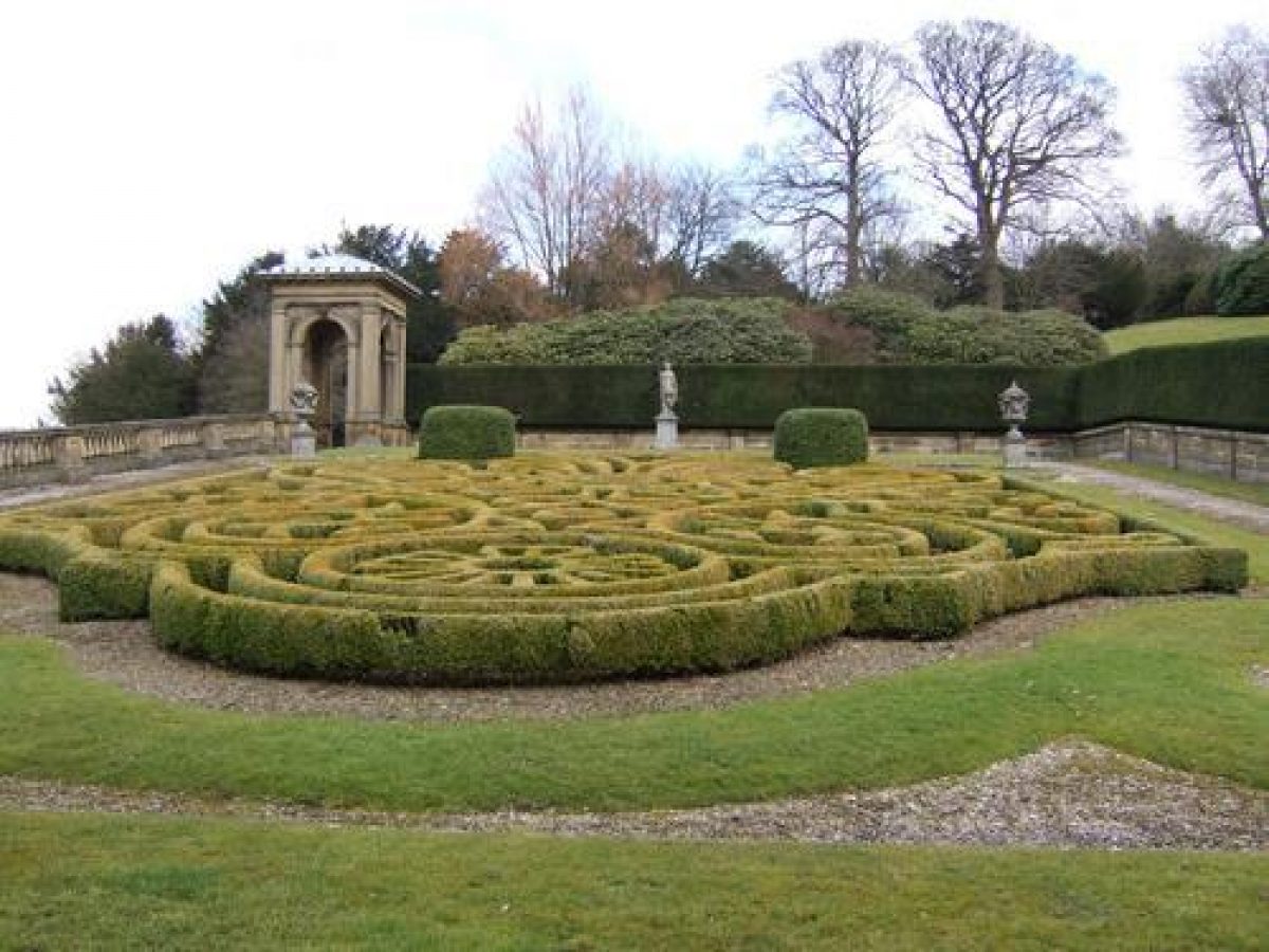
On the north side of the Hall there is a gravelled forecourt supported by a stone revetment wall with a parapet (c 1855, listed grade II). There are views to the north over parkland and the canalised Broughton Beck. On the east side of the Hall there is a rectangular walled garden, with a balustrade along the north side, designed by W A Nesfield (1793-1881) with an Italianate gazebo at its north-east corner, c 30m east of the Hall (wall and gazebo c 1855, listed grade II). The garden is planted with an elaborate scrolled parterre, designed by Nesfield and replanted 1899-1900 using his original design and instructions but omitting the coloured gravels of the original layout. On the south side of the Hall there is another similar parterre, also replanted late C19, set on level ground and surrounded by retaining walls which separate it from a steep slope to the south. An Italianate fountain backed by a balustrade lies against the southern wall flanked by balustraded stone steps leading up to sloping lawns to the south (steps, fountain and walls c 1855, listed grade II). A conservatory (c 1855, listed grade I with the Hall) is attached to the south side of the Hall projecting into the garden, with a central bowed south front with stone columns supporting a glass dome. Nesfield designed the layout and parterres while the buildings and structures, including the north forecourt, were probably designed in collaboration with Andrews & Delaunay.
The ground rises to the south of these gardens and grassy slopes, flanked on the east and west sides by clumps of shrubs and trees, overlook the gardens. Paths from the steps lead to the top of the slope where there is a level platform and a stone wall dividing the garden from parkland. There are views south across the park with rolling agricultural land beyond. A sketch of c 1755 (CL 1950) shows the land to the south of the Hall scooped out and shaped with a bow aligned with the south front. A note on the plan refers to 'A slope which rises to five feet perpendicular', south of which was a 'seven foot fosse from which the ground rises moderately'. This layout is suggested on the 1771 map and may have been the arrangement found by Nesfield who was probably responsible for smoothing and levelling the top of the 'fosse'.
Walks lead from the sloping lawns, those to the west threading through pleasure grounds planted with trees and shrubs within which a circular two-seater privy, with rusticated door surrounds and a plaque with the date 1819, lies c 40 m south of the Hall. A path runs along the north side of the pleasure grounds to a gate and continues across the drive leading to the home farm to a second gate of elaborate wrought-ironwork design. The path runs south-westwards through lawns which are bounded on the east side by a clipped yew hedge concealing the drive and the smithy. The route continues to an elaborate ironwork gate in the east wall of the kitchen garden. The woodland and route leading to the kitchen garden is shown on the 1848-50 OS map, while the 1771 map shows a more substantial area of woodland extending over the kitchen garden area.
On the east side of the Hall walks lead off from the sloping lawns to an area called The Grove which is a substantial block of woodland planted largely with yews and pines on the east side of the site. It is separated from the park on the south side by a ha-ha with a walk running alongside it from the south-west corner of the area for a distance of c 80 m to the east, and from that point by a wall which continues to the south-east corner of the area and then turns and runs north along the east side of the woodland to a point immediately opposite Middle Lodge. A system of paths, most of them lined with small boulders, runs through the woodland. One path leads east from the gazebo and another runs around the perimeter, with linking paths between them. In the south-east corner, c 350 m east of the Hall, there is a pool and a streamlet runs south from it alongside the perimeter path. Paths lead down to the east drive, some reaching it from short flights of stone steps, and continue through woodland on the north side of the drive. The Grove is shown with a perimeter path and seats positioned in various places on the 1848(50 OS map while the 1771 map shows the area as a block of woodland. A note dated 1730 amongst estate papers records a gardener being sent to Stonyhurst (qv) 'To get yews for the grove' (quoted in CL 1950) which raises the possibility that the area was part of the gardens at this time and that some of the yews may date from this period.
The woodland on the north side of the drive opens to a grassed walk backed by a screen of yews laid out by Nesfield c 1855 along the banks of the Broughton Beck, from which there are views along the river with a smooth cascade, which lies c 200 m north-east of the Hall, in the foreground. The cascade is not marked on the 1848-50 map and may have been created as part of the works by Nesfield. On the north-west side of The Grove, at the point at which the drive emerges into lawns, there is rockwork on each side of the route, that on the north side being formed of naturalistic boulders and that on the south side including the remains of a small classical structure and a datestone of 1817, conceivably one of the seats marked on the 1848-50 OS map.
Kitchen Garden
The kitchen garden, c 100 m south-west of the Hall, is a large brick-walled enclosure with range of converted buildings along the north side. It is shown on the 1848-50 OS map but not the 1771 county map. Interior features have been cleared and it is disused (1998).
Park
On the north side of the Hall there is open grassland with scattered trees on each side of the Broughton Beck, which has been dammed and canalised to form a wide, smooth stretch of water. There is no obvious sign of canalisation on the (small-scale) 1771 county map, but this is shown on the 1848-50 OS map. On the west side the land rises and the planting along the skyline, which includes yews, gives a sense of closure to this side of the site.
Parkland on the east side of the Hall extends on each side of the east drive, which is sheltered by Dancliff Plantation to the south, as shown on the 1848(50 OS map. Both the 1848-50 and 1910 OS maps show the route planted for part of its length as an avenue. The parkland to the south of the Hall is open pasture with trees and clumps including two clumps encircled with cast-iron fencing which contain a mixture of evergreen and deciduous trees. Sandwells Plantation shelters the east side of the park, and parkland runs down to the edge of the disused railway, as shown on the 1848-50 OS map. The 1771 county map shows the park surrounded by a pale covering an area which coincides approximately with the present extent of the parkland with the exception of the eastern stretch alongside the drive. The eastern edge of the park in 1771 approximated with a line running along the edge of The Grove and continuing along the line of Sandwells Plantation. Two avenues are shown radiating from a bowed clearing on the south side of the Hall. One ran south-east to the edge of the park while the other ran south-west and then curved around to the south of the area now occupied by the home farm. It is possible that some of the mature trees are survivors of these avenues. The map also shows a rectangular pool at the south end of the park, possibly in an area disturbed by the construction of the railway.
The park was probably laid out in approximately its present form during the early C19, possibly at the same time as the construction of the early C19 structures in the pleasure grounds or possibly some years later in the 1830s when Webster was remodelling the Hall and designing Middle Lodge.
Maps
- T Jefferys, County map, 1771
- OS 6" to 1 mile: 1st edition surveyed 1848-50; 3rd edition published 1910
- OS 25" to 1 mile: 2nd edition published 1909
Description written: December 1998
Edited: October 1999
- Visitor Access, Directions & Contacts
Access contact details
Open by appointment only. Telephone 01756 799608 for further details.
- History
The following is from the Register of Parks and Gardens of Special Historic Interest. For the most up-to-date Register entry, please visit the The National Heritage List for England (NHLE):
11th - 13th Century
Land in the area was owned by Roger de Poitou in 1066 and lands may have been granted to the Tempest family at about that time. There are records of the family owning lands in Craven by the middle of the 12th century.
14th - 15th Century
An undated 14th-century document records the acquisition of a house, watermill and part of the manor of Broughton by Sir John Tempest. The estates were consolidated at the beginning of the 15th century when Roger Tempest married Kate Gillio or Gilliot who brought with her the half of Broughton Manor not already owned by the family.
17th Century
Following sequestration of the estate in 1644 Stephen Tempest bought it back, only to have it sequestered again in 1653 and not returned until the Restoration.
20th Century
The estate continued in the Tempest family and remains in private ownership (1998).
Period
18th Century (1701 to 1800)
- Associated People
- Features & Designations
Designations
The National Heritage List for England: Register of Parks and Gardens
- Reference: GD2060
- Grade: II
The National Heritage List for England: Listed Building
- Grade: I
Features
- Conservatory
- Description: A restored early 19th-century conservatory with a cupola.
- Fountain
- Gazebo
- Key Information
Type
Park
Purpose
Ornamental
Principal Building
Domestic / Residential
Period
18th Century (1701 to 1800)
Survival
Part: standing remains
Hectares
75
Open to the public
Yes
Civil Parish
Broughton
- References
References
- {English Heritage Register of Parks and Gardens of Special Historic Interest}, (Swindon: English Heritage, 2008) [on CD-ROM] Historic England Register of Parks and Gardens of Special Historic Interest
- Country Life, 107 (31 March 1950), pp 876-9; 169 (29 January 1981), pp 270-2 Country Life, 107
- pp 149-50 The Buildings of England: Yorkshire The West Riding
- p 74 The Oxford Companion to Gardens
- Related Documents
-
CLS 1/148/1
A proposal for restoration for the parterre at Broughton Hall, Yorkshire - Hard copy
Sophieke Piebenga - 1984
-
CLS 1/148/1