Introduction
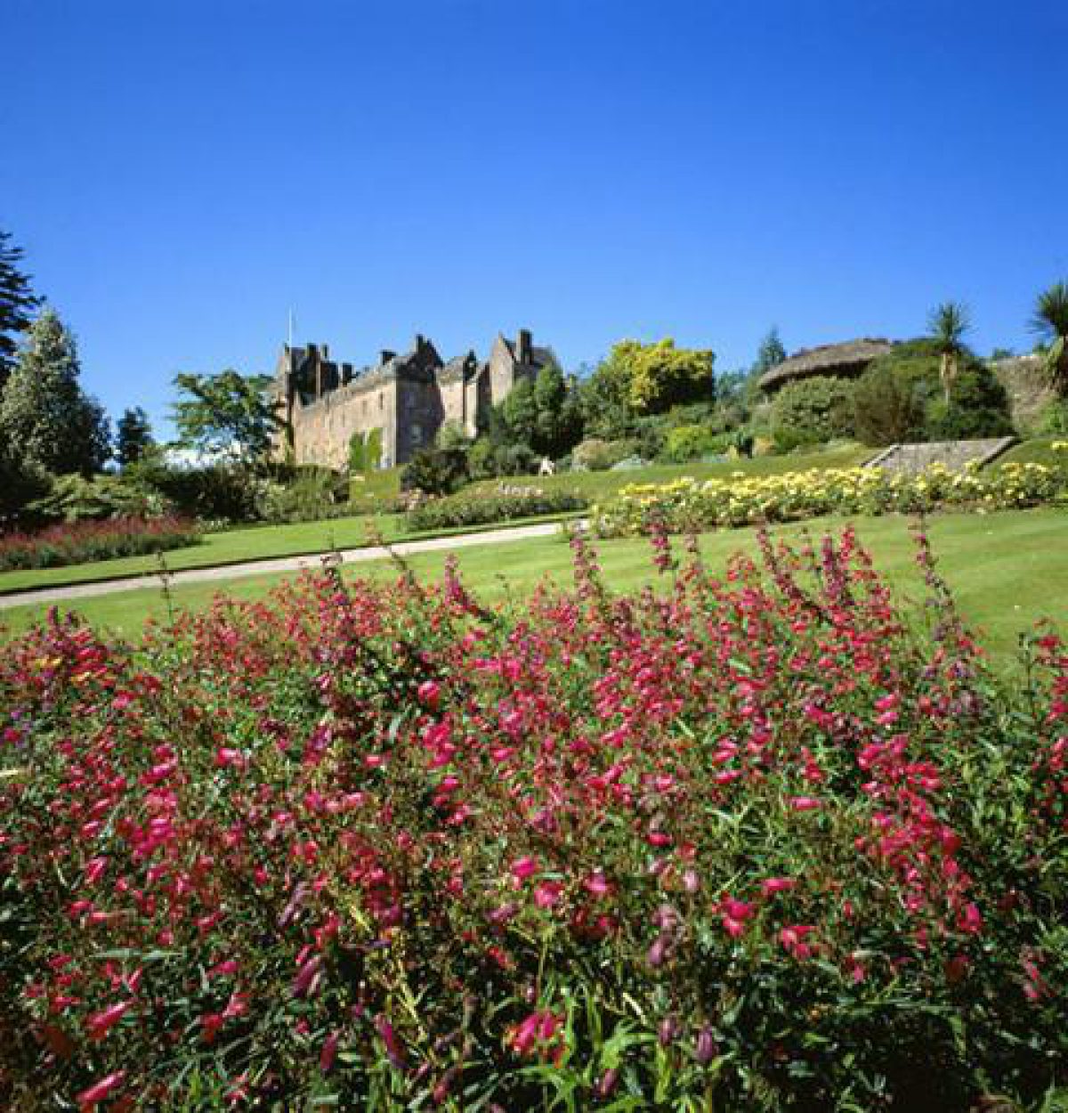
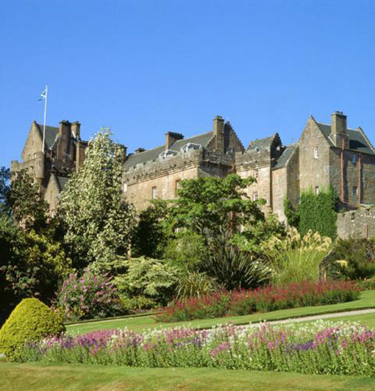
Brodick Castle has a magnificent setting on the east shore of the Isle of Arran with views to the mainland. The estate runs from seashore to mountaintop and comprises 18th- and 19th-century parkland, woodland walks with waterfalls, a formal walled garden and informal woodland gardens. The walled garden holds a wide variety of plants, many of them tender.
http://portal.historic-scotland.gov.uk/hes/web/f?p=PORTAL:DESIGNATIONS:0
Type of Site
Extending from sea-shore to mountainside, Brodick Castle is a large, multi-phase designed landscape incorporating an 18th-century improvement landscape (enclosures, parks and woodland), a 19th- century Highland estate (Romantic walks, formal approaches, specimen trees and architecture) and 20th-century woodland gardens with an important and diverse horticultural collection.
Location and Setting
Brodick Castle is a large, scenic and prominent designed landscape located on the eastern shore of the island of Arran. The grounds stretch from the coast road on the north side of Brodick Bay well up the side of Goatfell, the highest peak within the mountainous granite interior of north Arran. The castle itself stands on a large bedrock spur. It overlooks steep terraced lawns and is immediately surrounded by open garden grounds and mixed woodland gardens. Open pasture extends further upslope and to the west, down towards Glenrosa, while further woodland and forestry plantations occur towards the outer areas of the designed landscape and along the higher contours. Together, these elements make a very significant contribution to the local landscape by virtue of their scale and contrast with the surrounding sea-scapes and the bare hill and mountain slopes of north Arran. In views from the Firth of Clyde and across Brodick Bay, the designed landscape is the most important visual feature along this stretch of coastline. Focal interest is provided by the parks and open gardens. Interrupting the blanket of tree-cover, they also provide the setting for the castle itself. Goatfell and the rugged skyline above, meanwhile, form an impressive backdrop.
Within the designed landscape, the dominant characteristic of the topography is the gradient, and it is this sheltered south-east facing aspect that protects the gardens from Atlantic blasts and along with the mild climate, helps to create favourable growing conditions for the tree and plant collection. Flatter terrain occurs near Glenrosa Water where three standing stones of the Late Neolithic/Early Bronze Age form distinctive landmarks in the open fields. Elsewhere, watercourses, ancient raised beaches and the process of glaciation have created more dramatic landform such as gorges, rocky cliffs and deep hollows. All of these have been incorporated to some extent or another into the design or practical working of the estate and contribute to the overall experience of the designed landscape. This is particularly evident from the extensive network of 19th-century paths and rides, from where there are panoramic viewpoints across the designed landscape and Brodick Bay and to landmarks such as Dun Fionn and Merkland Point, and also more intimate, enclosed garden scenes of rocks, pools, hanging mosses, ferns and waterfalls.
Landscape Components
Architectural Features
Brodick Castle is the centrepiece of the designed landscape. It is a large, multi-period, country house in pink coursed rubble with eye-catching tower. Prominent in long-distance views across Brodick Bay, it contains fabric dating back to the 13th century. In its present form, it is mainly the creation of James Gillespie Graham (extensions and remodelling 1844).
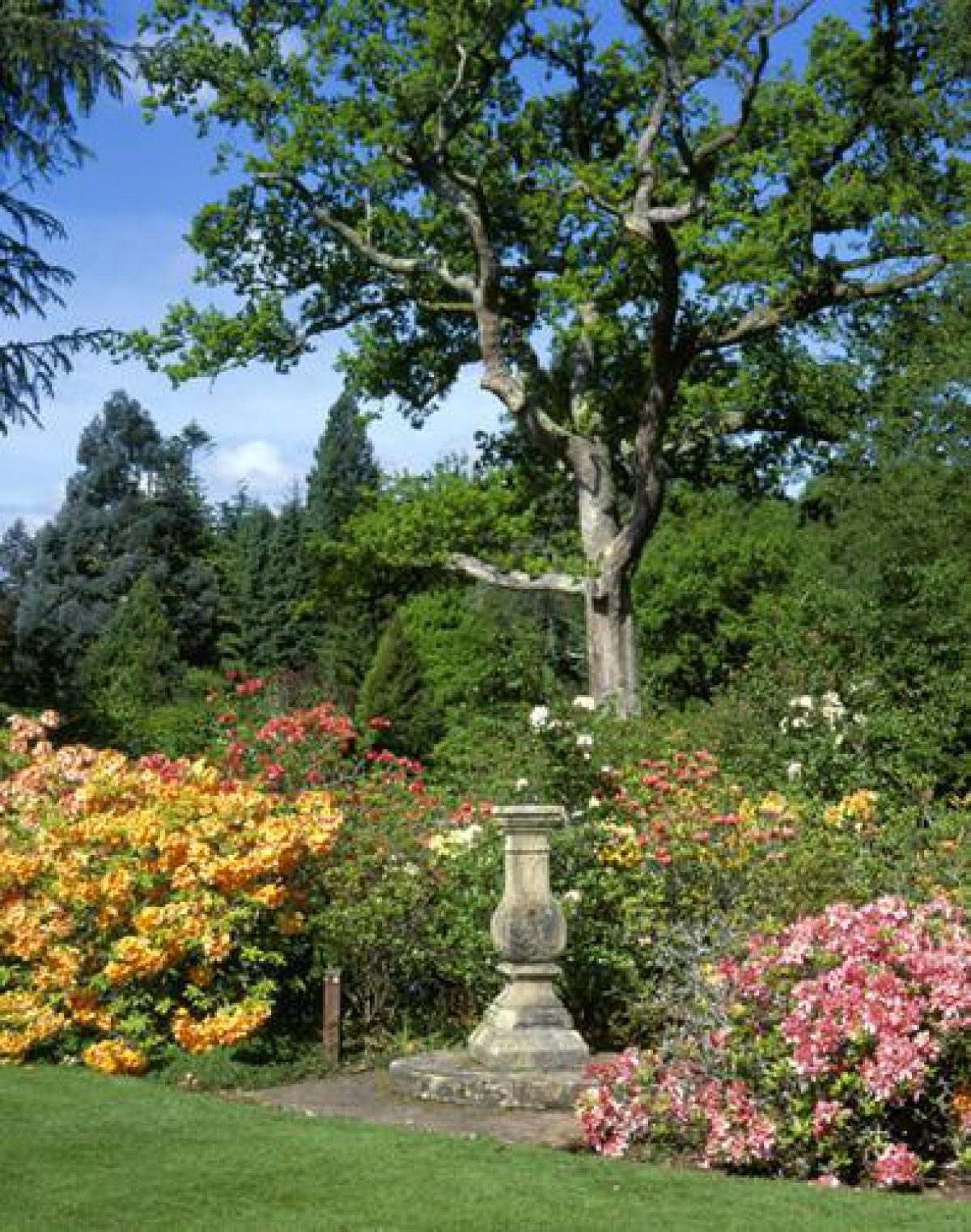
The castle overlooks steep, landscaped grass terraces and, to the south-east, a rectangular-plan, ornamental walled garden dated 1710, with red sandstone rubble walls, bee-boles, composite sundial and decorative wrought iron entrance gates.
The nursery is a second, larger garden enclosure, located along the southern boundary wall. Dated 1769, it is irregular in plan with pink sandstone rubble walls. Associated buildings include the 19th-century Gardener's Cottage, bothy, office and boiler house.
Key architectural features in the immediate environs of Brodick Castle include a domed, mid -19th century ice-house, and to the north, a pair of 1885 single storey, rectangular plan cottages known as Castle Cottage and Greenhyde Cottage. A clamp kiln for producing lime was revealed near Mill Burn to the west of the castle during excavations in 2003-4.
Nineteenth-century landmarks on the approach to Brodick Castle include the spectacular 12-sided rustic Bavarian Summerhouse (1845), perched high up on rocks above the coast road and decorated with intertwined rhododendron branches, and William Andrews Nesfield's main gates and entrance drive (c.1852) featuring cast iron gates, square gatepiers, quadrant walls and a curved carriageway built up on a raised causeway. The more modest south gate, by Rosa Bridge, and the west gate, at the end of the coastal boundary wall are later and feature simpler piers and ironwork. From the south gate, the drive leads over the Cnocan Burn road bridge, a round-arched, single span bridge in Roman style built in 1861 to span the deep ravine of the burn and to provide a romantic spectacle on nearby riverside walks.
A low stone boundary wall marks the edge of the designed landscape along much of the coast road. The section from the nursery to the main gate is 19th century, while the drystane dyke from the main gate to the north east is earlier and probably a surviving fragment of a wall that preceded Nesfield's entrance scheme.
Other notable architectural features are the 1858 kennels, with principal Tudor-style house, and Sylvania, (1913) an L-plan villa in Cladach originally for the Head Factor, then later for the Head Gardener. A harled and limewashed, 2-storey former inn (Brodick, Cladoch) also stands among the cluster of buildings in this southern part of the designed landscape.
A replica Bronze Age roundhouse (2012) in woodland above the castle is a venue for educational events and activities.
Drives and Approaches
The terrain at Brodick presented both obstacles and opportunities for the creation of approaches and scenic carriage rides. In 1800, the only entrance of any significance was a steep route via Cladach (Bauchop maps 1811, see RHP series under references). By 1900, the different areas of the designed landscape were connected by a substantial network of carefully engineered drives, rides and paths that not only provided access, but also reflected the status of the property and contributed to the experience and perception of the designed landscape as a whole.
Three main entrance drives were established between c.1852-1911. The principal approach by Nesfield remains the main access drive to the castle. Leading from the coast road, the main gates of c.1852 mark the start of a curving, uphill route. It represents a significant feat of engineering as estate surveyors and workers were required to realign and raise the public coastal road, erect sections of sea-wall, cutting into rock, and construct a raised causeway. The west entrance (no longer in public use) offered an alternative garden route into the grounds, while the longer drive via the south gates and over Cnocan Burn bridge allowed primary access to the kennels. This is now the exit route for visitors to the castle and is distinguished by the high, mature beech hedges which line the drive through the southern parks.
Paths and Walks
The surviving network of carriage rides and paths is now a significant resource for walkers and cyclists with all of the original 1843-63 routes incorporated into a series of modern trails and walks (The National Trust for Scotland: Trails Guide). Longer circuits, including the historic Balmoral ride, traverse the higher grounds of the designed landscape, while more intricate paths snake their way along Mill Burn, the Merkland Burn and Cnocan Burn gorges and through the lower woodland garden grounds. Laid out from 1843-63, they represent a key stage in the historic development of the designed landscape and are an important example of 19th century Romantic landscape style.
The overall layout is attributed to Princess Marie of Baden (Landskip and Prospect 1998: 35-36). She devised landscape plans with her friend, the artist George Hering (1805-79), who supervised the construction of pathways in 'adjacent woods and unfrequented places', following routes that he had visualised (Stirling 1954:20 Addyman and Oram 2009). Designed to inspire a sense of wonder in the landscape, these ornamental walks gave access to key viewing points and connected places of natural and designed beauty. In 1844, the author Thomas Dick Lauder moved through this landscape by phaeton and by foot, noting in his journal the 'enchanting woodland scenes', fine trees, views and rocks (quoted in Addyman and Oram 2009, Vol. II). The 1st edition Ordnance Survey map identifies an accompanying infrastructure of bridges, seats and summerhouses, including a prospect summerhouse known as the 'outlook' on the upper reaches of the Merkland Glen. These were mostly lost by circa 1914, although more recent field survey work has identified some surviving material remains (Landskip and Prospect 1998: 44-46).
In the present designed landscape, the surviving paths together with the canopy of mature trees, interesting landform and remaining flamboyant architecture ensures the general survival of this important and picturesque aspect of the designed landscape. Landmarks of particular note include the 1845 Bavarian Summerhouse, the ravine-spanning Cnocan Burn Bridge and the picturesque waterfall. Meanwhile, ongoing work by the National Trust to manage the woodland gardens along the shore means that some key landscape views along the routes are being regained.
Parkland
Policy grasslands within the designed landscape include Castle Parks to the north of Brodick Castle, the Greenhyde and Kennels Fields to the north-west, and the Old Deer Park to the west by Glenrosa Water. These open grounds contribute visual interest to the local landscape (where large blocks of lowland pasture are scarce) and form part of the setting of key architectural and archaeological features, including Brodick Castle itself and three prehistoric standing stones. These parks were created within the context of a wider programme of major agricultural change on Arran in the 18th and 19th centuries, and as such, represent an important phase in the early development of the designed landscape.
The layout and form of the parks originates from John Burrel's 1766-82 programme of agricultural improvement on Arran. Previously, these grounds had been farmed by a small population of tenants living in the minor settlements that surrounded Brodick Castle. Burrel's own journals help chart the transition of this land from clachan and township farmland to improved pasture with entries from the 1770s detailing the production of tens of thousands of trees for shelter-belts and recording instructions on dyke-building, returning arable to grazing and levelling old water-courses (Landskip & Prospect 1998: 25-8). Around this period, Castle Parks was divided into six rectangular enclosures with dykes and shelter belts (Headrick 1807: 38; Bauchop 1811).
The prominence of Castle Parks in landscape views lends weight to the idea that Burrel's regular enclosures formed a very public proclamation of 'modern' agriculture (Landskip & Prospect 1998: 16). In 2006, the National Trust for Scotland planted trees and hedges along the line of the old field boundaries in order to restore this unusual and historically important element of the designed landscape.
Burrel was also interested in the aesthetic properties of the shelterbelts and enclosures (Landskip & Prospect 1998: 26). From circa 1811-64, the work that he started on a new verdant and pastoral setting for the Castle was completed with the removal of most of the visible remains of the old clachans, the extension of parkland westwards into Mossend and along Glenrosa Water, the planting of individual specimen trees in this area and the population of the parks with deer (Bauchop 1811; Ordnance Survey map 1864).
Woodland
Modern commercial softwood plantations occur in large swathes across the higher contours of the designed landscape, while mature mixed woodlands extend between Cnocan Burn and Cladach (Easeanach Woodland), from Cladach to the south east corner of Castle Parks (Garden Woods) and in some lower lying parts of Merkland Wood. Offering colour and texture in panoramic landscape views, these woodlands provide an important visual frame for Brodick Castle and Castle Parks. The canopy also provides the setting and context for other historic landscape components, such as the 19th-century rides and paths, and is of considerable importance for wildlife and biodiversity. Both the scenic and nature conservation value of the woodlands is likely to be enhanced in future decades as the National Trust for Scotland plans to establish more areas of mixed woodland (Scots pine, oak, hazel and ash) in the wake of forest tree harvesting operations.
Although the origins of the woodland setting for Brodick Castle can be traced back to the enclosure of Castle Wood in 1703, large-scale tree production and planting did not commence until later in the 18th century. Estate records from 1770-1810, together with John Burrel's accounts, are sufficiently detailed to show exactly how many trees were ordered, cultivated and planted out at Brodick Castle during this period (over 220,000 in total), and which varieties dominated in each particular plantation (Landskip and Prospect 1998: 27-8). The fruits of this labour are evident in a variety of documentary sources. Thomas Pennant observed 'flourishing plantations' as early as 1772 (Pennant 1776: 195), while a mature and increasingly extensive woodland canopy is evident from Bauchop's map of 1811 (NAS RHP6601/2). The landscape paintings of the 1850s by Nesfield and George Hering, meanwhile, illustrate the woodlands in a pattern which (barring the later commercial forestry plantations), is instantly recognisable as that which exists today.
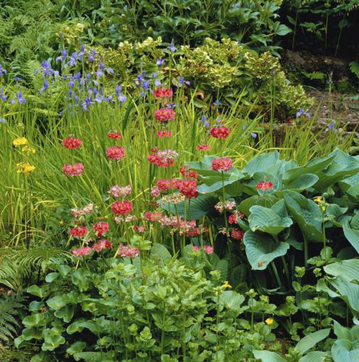
Woodland Garden
Woodland gardens extend from the lawns and formal terraces immediately around Brodick Castle and across the lower contours of the designed landscape. They contain a wide range of exotic trees and plants which, as a whole, is a major horticultural resource. There are three Plant Heritage National Collections recognised by the National Council for the Conservation of Plants and Gardens (NCCPG), (Rhododendron sub-sections Falconera, Grandia and Maddenia) and numerous UK, Scottish and county champion trees (Champion Tree Database Search). These gardens represent early 20th century development within the designed landscape.
The collection was begun in c.1920 by the Duchess of Montrose who sought out seeds and plants from other notable gardens and who may have subscribed to plant-hunting expeditions to China, the Himalayas and Upper Burma. Her son-in-law and fellow plant enthusiast, Major Boscawen proved a willing and useful assistant and during the 1920s-30s, the gardens were extended beyond the shelter of the gorges into several 'character' areas including a moraine garden, rock garden and pond garden. While some of these elements proved unsustainable (Land Use Consultants 1987: 198), the gardens nevertheless thrived with the influence of the North Atlantic Drift, rich soils and sheltering topography ensuring the fast growth of exotic species. By the 1950s, the woodland garden had taken its place among other nationally recognised specialist gardens, and it remains a very important element in the fabric of the designed landscape. In 1962, a donation of plants by Sir James Horlick from Achamore House on Gigha augmented the collection and now forms the basis for the Horlick Garden to the south-west of Brodick Castle.
The Gardens
Formal grass terraces descend to the south of the castle. Connected by stone steps and paths, they are located at the point where the natural sandstone spur on which the castle stands drops steeply away (Addyman and Oram 2009: 15). The terraces may have formed part of William Andrews Nesfield's otherwise largely unexecuted landscape scheme of 1852 (Addyman and Oram 2009: 95-96, although this is not the view held elsewhere, see Landskip and Prospect 1998: 30-31).
Lawns extend to the north and east of the castle and feature mature native and exotic trees including several varieties of fir, sweet chestnut, monkey puzzle and a Bhutan Pine. Further south, and bordering with the more expansive woodland gardens (as described above) is a Bog Garden, notable for its primulas and carnivorous plants and a rockery with shrubs, grasses and mosses.
Formal parterres were designed for the gardens at Brodick Castle by Nesfield (1852), William Burn (1857) and Reginald Blomfield (1919), but none of them were executed (Landskip and Prospect 1998: 31-33).
Walled Garden
The earliest of the two walled garden enclosures is dated 1710. Located immediately to the south-east of Brodick Castle, it forms a conspicuous and important element within the historic garden landscape.
Built as the original kitchen garden, it also held tree-nursery stock in the 1760s and 1770s (Landskip and Prospect 1998: 26). Once Brodick Castle became the chief residence of the Hamilton family from 1843, the former practical functions of the garden were transferred to the lower walled garden and this prime area of sloping, enclosed ground was converted to ornamental use complete with lawns, borders, symmetrical beds and summerhouse (later a pavilion) (Ordnance Survey Map 1864, photo 1896 reproduced in Greenoak 2005: 18). This general ornamental character remains, with the present layout devised by the National Trust in 1982 using photos and other documents of the 1920s and 1930s as guidance. In addition to its historic architectural features (sandstone walls, gates, bee-boles and sundial), the garden is distinguished by its tender flowering shrubs, exotic trees, and the lower circular garden with interesting plant combinations. A heather hut, built in 1984 provides shelter and overlooks the garden.
The later walled garden, located further down the slope, is also an early component of the designed landscape. Dated 1769, it was probably built on and around a pre-existing tree-nursery (Listed Building Record Ref: HB6777). Intensive tree production continued on this site, with seedlings stored and grown by their tens of thousands in the 1770s and 80s for shelterbelts and woods. In circa 1840-60, this garden assumed the role of the main kitchen garden for Brodick Castle, and the 1st edition Ordnance Survey map illustrates a traditional quadrant layout, with glasshouses, boilerhouse and bothy (1864). Today (2013), the garden bears witness to many incremental changes from the 1860s onwards, from the provision of a Gardener's Cottage sometime between 1864-1900, to the breaching of the garden wall in the 1950s to allow vehicle access to the neighbouring saw-mill. A single, timber framed glasshouse of circa 1930 survives, while dwarf walls relate to the site of an early glasshouse, itself replaced by a glasshouse brought from Buchanan Castle in 1948 (and removed in the 1980s). Later interventions include the construction of Shore Lodge in the south-east quadrant, a new tractor shed and a series of modern, metal framed glasshouses.
- Visitor Access, Directions & Contacts
Telephone
0131 668 8600Access contact details
The country park is open daily throughout the year. The castle and walled garden are open daily between April and October.
Directions
Brodick Castle is 1.5 miles from Brodick pier. Buses meet every ferry. For details see: http://www.nts.org.uk/Property/Brodick-Castle-Garden-and-Country-Park/Getting-there/
Owners
The National Trust for Scotland
- History
The following is from the Historic Environment Scotland Gardens and Designed Landscapes Inventory. For the most up-to-date Inventory entry, please visit the Historic Environment Scotland website:
http://portal.historic-scotland.gov.uk/hes/web/f?p=PORTAL:DESIGNATIONS:0
Reason for Inclusion
An exceptional and scenically important designed landscape with a renowned horticultural collection, nationally important architectural and archaeological features and, in the form of the surviving rides and paths, an excellent example of the 19th century Romantic landscape style. Parks, gardens and woods provide significant nature conservation value, while the story of the designed landscape's development is charted by a varied collection of historical estate records, accounts, paintings and maps.
Main Phases of Landscape Development
circa 1700-1715; 1766-1820s; 1843-63; 1920s-1957
Site History
Brodick Castle designed landscape is the product of four key phases of landscape intervention and design from circa 1700 through to the 1950s. These phases all took place under the ownership of the Hamilton family and encompass the early development of the castle environs at the start of the 18th century, major improvement and planting work from the 1760s-1820s, the elaboration of Brodick as a Highland Victorian estate in 1843-1863, and the creation of the woodland gardens from the 1920s-1957.
The castle itself has a much longer history with recent research and fabric analysis charting a highly complex sequence of building, modification, destruction and rebuilding from the 13th century onwards (Addyman and Oram 2009: 10). Occupying a naturally defensible spur of sandstone bedrock, the early castle functioned as a military stronghold in a contested landscape with its history from the 13th to 15th centuries bound up with the struggles of the Scottish Crown in trying to secure and maintain control in the west. The natural topography of the site defined the defensive perimeter of the castle and both historical records and archaeological investigation testify to the presence of a moat, the line of which could still be partially traced in 1844 (Martin 1999: 138; Addyman and Oram 2009: 38-39; New Statistical Account 1845: 22).
In 1503, James IV transferred Arran to the Hamilton family and Brodick Castle became the hub of a quasi-feudal estate. Initially, defensive capability remained important. With noble feuding in the 16th century and the Wars of the Three Kingdoms (1638-1660), the castle periodically housed garrisons, came under siege and required major investment for building works and repair. This era, however, represents the final days of the castle as a viable fortress. As political stability increased from 1660, and the Hamilton fortunes recovered under Anne, Duchess of Hamilton (1632-1716), the role of Brodick Castle shifted away from defensive bastion to that of occasional summer residence, hunting lodge and centre of estate management.
The early origins of the designed landscape can be traced to this shift. Although Arran was a peripheral and seldom-visited part of the Hamiltons' vast estate, funds were nevertheless directed to the upkeep of Brodick Castle and to the development of its immediate grounds. Castle Wood was enclosed in 1703, the walled garden was built in 1710, and in 1714, a gardener on the payroll could be found 'training up young trees and trenching them about the castle' (Addyman and Oram 2009: 62).
The next phase of development was the radical reorganisation of the wider landscape surrounding Brodick Castle. For much of the 18th century, this was a landscape of small rural settlement, fields, runrig, pasture, coppices and tracks, with the land worked communally by groups of tenants and subtenants jointly responsible for the rent (Storrie 1967: 51). As programmes of agricultural improvement and Highland clearance gathered pace elsewhere in Scotland, the Hamilton family sought to modernise Arran, secure in the conviction of their own 'civilising duty' and the likelihood of improved profits (Little 1999: 133). From 1766-82, John Burrel was appointed to the task. Described as a 'masterful and laborious man, who undertook his commission in the spirit of a crusader' (MacKenzie 1914: 174), Burrel enjoyed only limited success at an island-wide scale. At Brodick, however, his ambitions were more fully realised and Robert Bauchop's maps of 1811 capture a new, ordered and enclosed estate where regular improved fields proclaimed modern agriculture and where parks, shelterbelts and plantations offered a verdant, pastoral setting for the castle (NAS RHP6602, 6603). Vestiges of some of the old clachans remained, but these were isolated remnants of the former landscape, fully cleared away by the 1860s (Ordnance Survey map 1864).
Although aesthetic ideals were among the concerns of the Dukes of Hamilton and their agents during this improvement work, it was not until Brodick Castle finally became a full-time elite residence in the 1840s that the visual and experiential aspects of the grounds were prioritised. In 1843, the 10th Duke's eldest son married Princess Marie of Baden, a cousin of Napolean III. The union was celebrated by a major project to transform the estate into a suitable Victorian Highland home for the couple. While the architect James Gillespie Graham was appointed to enlarge and remodel the castle itself in 1844, other design projects focused on the surrounding grounds. Garden terraces were built, specimen trees planted, and the walled garden was grassed over and planted, becoming an arena for leisure and ornamental plants rather than food production (a function that was transferred to the lower walled garden further downslope).
One of the most significant design additions of 1843-63 was the elaboration of Romantic rides and walks in the glens and surrounding woods. Attributed to Princess Marie of Baden, with significant input by the artist George Hering, this conception of landscape conformed to wider contemporary trends for Romantic landscape, inspired by Sir Walter Scott, and also Princess Marie's native Bavaria (Landskip and Prospect 1998: 35-36). Formal schemes by external designers remained largely unexecuted, perhaps for reasons of taste, or dwindling finances, or both. From a comprehensive scheme proposed by William Andrews Nesfield in 1852, for example, only the main entrance gates and drive were constructed.
When the 12th Duke of Hamilton died in 1895, the accounts showed over one million pounds of debt (RCAHMS: Hamilton Palace). The title and entailed property passed to a distant cousin, while Brodick Castle went to the 12th Duke's only child, Lady Mary Louise Hamilton, subsequently the Duchess of Montrose. It was her input that shaped the next principal stage of landscape development; the creation of the woodland garden from the 1920s to 1957.
Venturing into the woods around and below the castle, where most of Princess Marie's seats and summerhouses had already been lost (Ordnance Survey map 1919), the Duchess of Montrose formulated plans to clear tangled woodland scrub, leaving only the best mature trees in place (Duchess of Montrose and Boscawen 1952: 7). Joined by her son-in-law, Major Boscawen, she created diverse garden areas and introduced many exotic flowering shrubs and rhododendrons, which thrived in the sheltered grounds and mild climate offered at Brodick. Her legacy was a new and striking dimension to the already complex, multi-period designed landscape.
In 1957, the estate was donated to the National Trust for Scotland. Brodick Castle and gardens remain under their management, while the wider landscape operates as a country park. Significant pieces of research and investigation, commissioned and undertaken by the Trust at the end of the 20st century and in the early 21st century, have revealed much about the history and development of the designed landscape and continue to shape future objectives.
Period
- 18th Century (1701 to 1800)
- Late 18th Century (1767 to 1800)
- Associated People
- Features & Designations
Designations
Historic Environment Scotland An Inventory of Gardens and Designed Landscapes in Scotland
Features
- Icehouse
- Description: The icehouse was restored in 1979.
- Earliest Date:
- Latest Date:
- Summerhouse
- Description: The 'Bavarian Summerhouse', an octagonal rustic gazebo decorated with fir cones.
- Earliest Date:
- Latest Date:
- Sundial
- Description: A sundial in the centre of the walled garden.
- Earliest Date:
- Latest Date:
- Castle (featured building)
- Earliest Date:
- Latest Date:
- Planting
- Description: Woodland garden.
- Key Information
Type
Estate
Purpose
Ornamental
Principal Building
Domestic / Residential
Period
18th Century (1701 to 1800)
Survival
Extant
Hectares
353.87
Open to the public
Yes
- References
References
-
Historic Scotland, 'Brodick Castle', {Gardens and Designed Landscapes},
- Peter McGowan Associates with Christopher Dingwall, 'Brodick', in {Ayrshire Garden and Designed Landscape Survey} (Prestwick: South Ayrshire Council, 2007) [on CD-ROM] Ayrshire Garden and Designed Landscape Survey
- Close, R. (ed), {Ayrshire and Arran: An Illustrated Architectural Guide} (Edinburgh: The Rutland Press, 1992), p. 210-2 Ayrshire and Arran: An Illustrated Architectural Guide
- Gordon, J. (ed), {The New Statistical Account of Scotland} ([n.p.]: [n.pub.], 1845), Vol. V, pp. 1-39 The New Statistical Account of Scotland
- {Ordnance Survey County Series Six Inch} (Southampton, 1854) Ordnance Survey County Series Six Inch
- Joan Blaeu {Atlas Novus - South Carrick/North Carrick/Kyle/Cunninghame} (Amsterdam, 1654) Atlas Novus - South Carrick/North Carrick/Kyle/Cunninghame
- Land Use Consultants, {An Inventory of Gardens and Designed Landscapes in Scotland} ([n.p.]: The Countryside Commission of Scotland, 1987), Vol. 2, pp. 195-201 and p. 388 An inventory of gardens and designed landscapes in Scotland
Contributors
Historic Scotland
-
Historic Scotland, 'Brodick Castle', {Gardens and Designed Landscapes},