Introduction
Berkeley Castle contains late-19th-century terrace gardens, lawns and trees covering around 3.2 hectares, surrounding a medieval Castle.
www.historicengland.org.uk/listing/the-list
Medieval castle with terraced gardens of 17th- to 20th-century date, adjoining Home Park, and Whitcliff deer park one kilometre to south-west.
DESCRIPTION
LOCATION, AREA, BOUNDARIES, LANDFORM, SETTING
Berkeley Castle stands on the south bluff of the plateau occupied by the small town of Berkeley, immediately south-east of St Mary's church, which originated as an Anglo-Saxon minster. The Castle looks south across flat, low-lying meadows flanking the Duverte Brook and the Little Avon River to Whitcliff Park, the Castle's deer park, and west over the flood plain (here the Berkeley Pill) of the River Severn which flows 3km to the west. The principal road serving the town is the B4066, running east from the A38 Bristol to Gloucester road to the riverside docks at Sharpness 4km north of Berkeley. Canonbury Street, the short unclassified spur west off this into Berkeley town bounds the park to the north, while the unclassified road from Berkeley to Ham forms its principal south-west boundary. The area here registered is c 190ha, of which c 130ha is the deer park.
ENTRANCES AND APPROACHES
The Castle itself is approached from the west, via a short lane off the High Street. The Castle's outer gatehouse (listed grade I) stands across this, with beyond the triangular outer bailey described by Leland as 'mitely strong' (quoted in CL 1955).
Another approach is via a drive from a small, square, C14 sandstone gatehouse (listed grade II) on Canonbury Street 300m north of the Castle. This gives access to the principal visitors' car park, north-east of the churchyard.
PRINCIPAL BUILDING
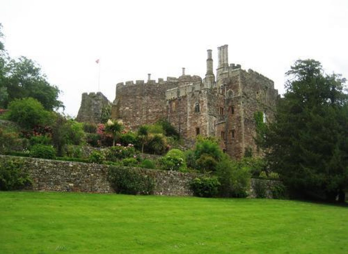
The core of Berkeley Castle (listed grade I) is the roughly circular shell keep of 1153, on the north-west side of which is the C14 Thorpe Tower, and on the south domestic apartments. Attached to the east and south-east of the shell keep is the inner bailey of 1160-90, completely ranged about by buildings, mainly C14 and including, in the centre of the east range, the great hall with to its south the chapel of St Mary, since 1923 a morning room. A gate at the west end of the inner ward, against the south side of the shell keep, gives access to the triangular outer bailey, to the west of the shell keep. Access to the Castle is via the gatehouse on its west side.
The early C20 restoration of the Castle is believed (Verey 1980) to have involved Philip Webb (d 1915), although the date of his death renders direct involvement unlikely.
GARDENS AND PLEASURE GROUNDS
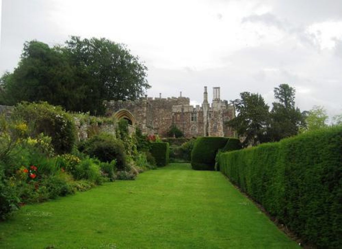
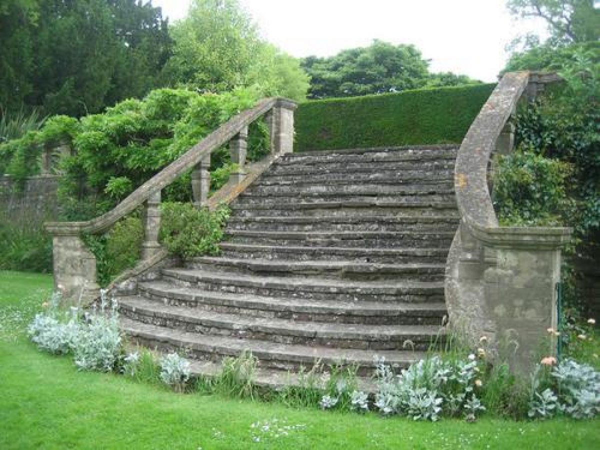
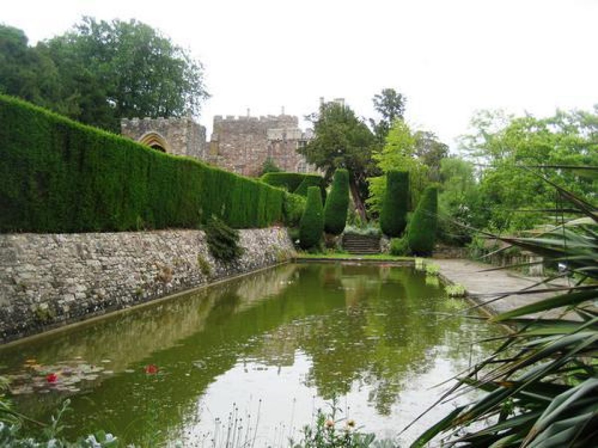
South and east of the Castle, overlooking the Vale of Berkeley, the sloping ground below the walls is scarped into stone-walled terraces connected by flights of steps. Beneath the walls of the inner bailey are two terraces; these continue as broader terraced gardens beneath the outer bailey, where there is a third, uppermost terrace. The two main terraces begin on the north-east side of the inner bailey, at the edge of the belt of woodland (including mature specimen trees such as beech, walnut, and yew) and shrubs which wraps around the north side of the Castle. The upper terrace is a 5m wide gravel walk with shrubs against and running up the Castle walls, the lower a 10m wide grass walk bordered with low shrubs and on its outer edge by a low box hedge. At the east end of the outer bailey flights of steps descend the terraces. West of the stairs both terraces continue for c 50m; here there is a third, uppermost terrace, c 5m wide and comprising a grass path flanked with flower beds. This, the terraces beneath, and the meadowlands beyond are overlooked from the low, canon-mounted wall of the outer bailey. This flight of three terraces ends below the gatehouse at the west end of the outer bailey. Here steps from the upper, gravel walk lead down to a straight, 100m long and 10m wide Bowling Green. This is bounded to the south by an ancient, 2m high yew hedge, and to the north by the stone wall which rises up to support the approach to the gatehouse. The east end of this wall is pierced, almost beneath the gatehouse, by a crude gothick-arched tunnel which gives access to a path along the moat bottom, through the woodland around the north side of the Castle. Steps at the west end of the lower, grass terrace, flanked by pairs of Irish yews, lead down to a flagged compartment around a c 35m long and c 8m wide formal Lily Pond, converted from an early C20 swimming pool. At the west end of the Pond is an early C20 stone shelter. Running along the south side of the compartment is C17 style stone balustrading, from the centre of which a flight of steps descends to the level, so-called Tilt Yard Lawn, which extends outwards from the lower terrace. Five Irish yews flank either side of the bottom of the steps. The Tilt Yard Lawn is bounded by the Duverte Brook, largely concealed to the south of the outer bailey and inner baileys by a billowing box hedge. Here the lawn is c 40m wide and has a few mature specimen trees, including a stand of Wellingtonia. East of the Castle the lawn narrows to c 20m, and there is no hedge; this allows views across the lush meadowland to the Kennels and Whitcliff Park.
Medieval account rolls record expenditure on the Castle's gardens, on herbs, and on apple and pear trees. A map of 1543 indicates the Castle's garden lay to the west, in the vicinity of the Lily Pond, with the orchard to its south, along the north bank of the stream. C17 paintings (reproduced in guidebook), for instance by Henry Danckerts (c 1625-80), suggest little, if any, terracing, and show the sloping ground beneath the Castle as lightly wooded. By the time Kip drew Berkeley (Atkyns 1712), however, the terraced gardens to the east and south of the Castle had been constructed, with the exception of the lowest terrace. Also present was the higher terrace beneath the Outer Bailey, and the Bowling Green to its west. Steps from the main terrace walk beneath the Castle walls led down to the flat ground, then bisected from east to west by a moat or canal, north of the brook. This area was wholly occupied by what appear to have been vegetable and fruit gardens and orchards, while south of the Bowling Green, in the area of the late medieval Castle Garden, was a grid of about twelve square plots. The gothick archway beneath the approach to the outer bailey gatehouse may be part of the works undertaken in the years after 1796, and may indicate the development of the walks around the north side of the Castle at this time. In 1880 (OS) the configuration of the terraces remained what it had been in Kip's time, although immediately south of the Bowling Green there was a conservatory or glasshouse while the flat ground north of the brook was planted with specimen trees, apparently largely coniferous. North of the Castle walks wound through mixed woodland. The Castle terraces were planted by Lady Georgina Fitzhardinge in the 1880s, followed in the early C20 by Major Robert Berkeley, who also developed the plant collections at Spetchley (Worcestershire, qv). It was in the time of Major Berkeley, after 1916, that the lower main terrace, and that around what was then a swimming pool, were constructed. His aunt was Ellen Willmott of Warley Place (Essex, qv) (d 1934), one of the most famous gardeners of her time, while among visitors to Berkeley were Gertrude Jekyll (d 1932) and Vita Sackville-West (d 1962).
PARK
The meadowland extends in an arc around the Castle from north-east to west, with the C14 gatehouse on its north edge; this is the Home Park. Internally it is almost wholly devoid of trees.
Household accounts of the 1420s show little venison was consumed at the Castle, suggesting it did not then have a park. By 1543 the land north of the Castle had been imparked. In 1573 Queen Elizabeth, who had come to hunt red deer, complained about Lord Berkeley ruthlessly felling oaks in his park. Twenty-five years later further felling took place when monumental, living, stumps of birch, the tree from which Berkeley takes its name, were uprooted. A century later when Kip included the Home Park on his view of Berkeley (Atkyns 1712) it was apparently open grassland, without trees. Neither a pale, nor deer, are shown.
Whitcliff Park, Berkeley's deer park, is c 1km south-west of the Castle, beyond the village of Ham. At the north end of the village, roughly midway between the Castle and Whitcliff Park, are the kennels and stables of the Berkeley Hunt. The main block, of brick, two-storeys, and with gothick details including battlements, is of c 1800 and forms an eyecatcher from the Castle and its gardens. Linking Kennels and Castle is a ride along the east side of the road to Ham; at its north end, c 150m west of the Castle, the Duverte Brook is crossed by an ashlar footbridge (listed grade II), probably also of c 1800.
Whitcliff Park, still (1999) with herds of fallow and red deer, occupies the north-east half of a low rocky ridge. It is roughly oval, 2.25km long and c 700m wide. It is surrounded by a brick wall, probably of the later C17 or early C18; some sections survive intact, elsewhere the solid wall has been replaced by brick piers connected by wooden rails. At the north-east end of the park is a mid C19 entrance lodge (listed grade II) with central arched gateway. In its gardens are various coniferous specimen trees, including Wellingtonia and Scots pines. From this a path runs south-west down the spine of the park. For c 200m, beginning c 300m south-west of the lodge, a line of mature horse chestnuts, limes, and oaks runs alongside the path. The parkland which slopes away off the ridge is tussocky grass, and there is a moderate density of mature parkland horse chestnuts and oaks, some of the latter stag-headed, interspersed with quite large numbers of recent, late C20, plantings in cages. A kilometre south-west of the entrance lodge, north-west of the spinal path, is Park House (listed grade II), a crenellated tower house-like structure of c 1800 with a multi-angular tower at each corner. Extending north-east from this is a block of mixed woodland including coniferous specimen trees; further blocks of planting, with Scots pine predominating, lie further south-west into the park. Some 400m south-west of Park House is a square moated site, possibly marking the site of an earlier lodge. From the ridge along the crest of the park there are long views north-west over the River Severn, south-east to the Cotswold Edge, and north-east back to the Castle.
KITCHEN GARDEN
The Castle's brick-walled kitchen garden, now partly occupied by a garden centre and Butterfly Farm and partly by an orchard, stands c 200m to its north, adjacent to the visitors' car park. In 1712, before the kitchen gardens were constructed, this was the north-west corner of the Home Park. The walls are of various phases of the C18 and early C19; probably also early C19 is the gothic-arched and crenellated gateway near the centre of the south wall. A C19 brick fruit wall (the west wall of the car park) leads south from the west side of the gateway.
REFERENCES
R Atkyns, The Ancient and Present State of Gloucestershire (1712), pl facing p 260
Trans Bristol & Gloc Archaeol Soc 19, (1894-5), pp 84-105; 48, (1928), pp 133-79; 70, (1951), pp 308-39
Country Life, 16 (23 July 1904), pp 126-35; 40 (29 July 1916), pp 126-32; (5 August 1916), pp 154-60; 118 (15 December 1955), pp 1430-3
D Verey, The Buildings of England: Gloucestershire The Vale and the Forest of Dean (2nd edn 1976, reprinted 1980), pp 98-104, 471
J Sales, West Country Gardens (1981), pp 40-1
N Kingsley, The Country Houses of Gloucestershire, Volume One, 1500-1660 (1989), pp 57-61
Berkeley Castle, guidebook, (Berkeley Castle 1997)
Maps
Berkeley estate map, 1543 (Map 68), (Gloucestershire Record Office)
OS 6" to 1 mile: 1st edition surveyed 1879-82, published 1886/8
OS 25" to 1 mile: 1st edition surveyed 1879, published 1880
Description written: May 1999
Register Inspector: PAS
Edited: March 2003
- Visitor Access, Directions & Contacts
Telephone
01453 810303Website
https://www.berkeley-castle.com/Access contact details
The gardens are open between March and October, but daily only in July and August.
Directions
Follow the A38 from the M5, signposted Berkeley.
Owners
Charles Berkeley and family
Berkeley Castle, GL13 9BQ
- History
The following is from the Register of Parks and Gardens of Special Historic Interest. For the most up-to-date Register entry, please visit the The National Heritage List for England (NHLE):
www.historicengland.org.uk/listing/the-list
HISTORIC DEVELOPMENT
Berkeley Castle was begun in about 1070, as a motte and bailey, by Fitz Osbern, Earl of Hereford. A shell keep, which survives, was constructed in the mid-12th century. Thomas, Lord Berkeley inherited the Castle in 1326 and began 'beautifying' (quoted in Kingsley 1989) it. In the following year Edward II was murdered here. A progressive remodelling of the living apartments began around 1340, certainly within the inner bailey and perhaps, too, in the outer bailey, the buildings within which were cleared in the 17th century. Thereafter, until the early 19th century, changes were relatively minor. Mary, the fifth Earl's Countess, the daughter of a Gloucestershire tradesman and his mistress for ten years before they married in 1796, seems to have been the moving spirit behind a building programme of 1805-7 when a gothick block was built abutting Thorpe Tower, and probably the Berkeley Hunt kennels constructed in the park. Thereafter, again, there was a long period when few changes were made, until 1916 when the earldom and Castle passed to the eighth Earl of Berkeley (died 1942) FRS. He 'was anxious to create at Berkeley a perfect medieval image at whatever cost in terms of the authenticity of the fabric' (Kingsley 1989). Having sold his London estate for £2 million he was financially well placed to do so. Real features were removed or altered, and others such as a screen and fireplace brought from elsewhere. In the private apartments modern living was accommodated with introductions such as an American bathroom. It was at this time that the gardens took on their present form. Berkeley remains (1999) in private hands.
- Associated People
- Features & Designations
Designations
The National Heritage List for England: Register of Parks and Gardens
- Reference: GD1747
- Grade: II*
Features
- Castle (featured building)
- Earliest Date:
- Terrace
- Earliest Date:
- Latest Date:
- Bowling Green
- Earliest Date:
- Latest Date:
- Terrace
- Earliest Date:
- Latest Date:
- Key Information
Type
Garden
Purpose
Ornamental
Principal Building
Domestic / Residential
Survival
Extant
Hectares
64
Open to the public
Yes
Civil Parish
Berkeley
- References
References
- Kingsley. N., {The Country Houses of Gloucestershire, Volume 1, 1500-1660} (Cheltenham: Phillimore, 1989), pp. 57-61 The Country Houses of Gloucestershire, Vol. I 1500-1660
- Verey, D., {The Buildings of England: Gloucestershire 2, The Vale and the Forest of Dean} (Harmondsworth: Penguin, 2nd edition 1976, reprinted 1980), pp. 98-104, 471 The Buildings of England: Gloucestershire 2: The Vale and the Forest of Dean
- {English Heritage Register of Parks and Gardens of Special Historic Interest}, (Swindon: English Heritage, 2008) [on CD-ROM] Historic England Register of Parks and Gardens of Special Historic Interest
- Sackville-West, V {More For Your Garden} (London: Michael Joseph, 1955) More For Your Garden
- Nicholson, H and Nicholson, N (ed) {Diaries and Letters 1945-1962} (Collins, 1968) Diaries and Letters 1945-1962
- Teasdale Environmental Design {Berkeley Castle, Gloucestershire. Landscape Conservation Management Plan} (2009) Berkeley Castle, Gloucestershire. Landscape Conservation Management Plan
- Related Documents
-
CLS 1/99/392
Berkeley Castle, Gloucestershire, Landscape Conservation Management Plan - Hard copy
Teasdale Environmental Design, Trowbridge - 2009
-
CLS 1/99/392