Introduction
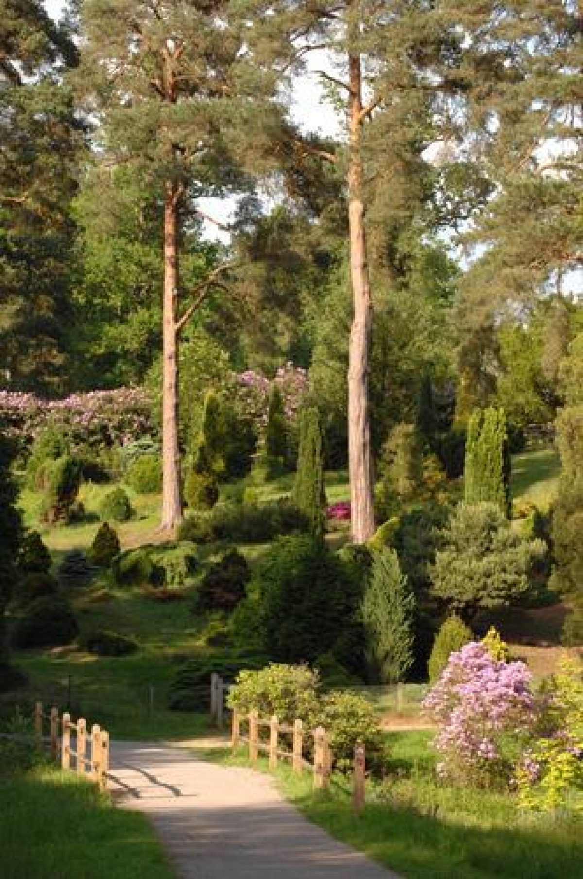
The National Pinetum at Bedgebury was established as the National Conifer Collection in 1925. It is now recognised as the most complete collection of conifers on one site anywhere in the world. The collection has over 10,000 trees specimens growing across 320 acres (129 hectares); including rare, endangered and historically important specimens. The Pinetum is home to some 91 vulnerable or critically endangered species and five NCCPG National Collections (Yew, Juniper, Thuja, Lawson Cypress and Leyland Cypress) and contains some of the oldest and largest examples of conifers in Britain.
Terrain
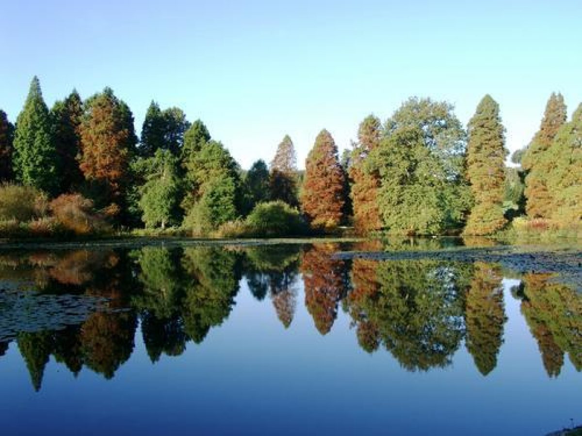
The rural site occupies markedly undulating ground falling generally to the north and divided into two main valleys running south to north, with streams meeting at Marshall's Lake in the centre of the northern boundary.The original walled garden of the house is now the car park. Notable features of the Pinetum landscape are the Spruce Valley, Swamp Cypress and Dawn Redwoods by Marshall's Lake, Western Hemlock and Thuja collections. Sixty acres of trial forest plots (150 plots each of ¼ acre) have been established by the Commission to assess the relative performance of various species.
Many superb specimens were lost in the 1987 storm, but the worst damage was in the wood near the car park.
The following is from the Register of Parks and Gardens of Special Historic Interest. For the most up-to-date Register entry, please visit the The National Heritage List for England (NHLE):
www.historicengland.org.uk/listing/the-list
A national pinetum developed by the Forestry Authority from the 1920s onwards, with a scattering of conifers planted in the late 19th century.
LOCATION, AREA, BOUNDARIES, LANDFORM, SETTING
Bedgebury Pinetum is situated on the east side of the A21, c 15km south-east of Tunbridge Wells. The c 40ha rural site occupies markedly undulating ground falling generally to the north and divided into two main valleys running south to north, with streams meeting at Marshall's Lake in the centre of the northern boundary. The Pinetum is bounded to the north by the grounds of Bedgebury Park School, to the north-east, east, and south by Bedgebury Forest, and to the west by farmland, currently (2002) being developed as an extension to the site.
ENTRANCES AND APPROACHES
The main access into Bedgebury Pinetum is from the western boundary. From Lady Oak Lane a drive enters the walled kitchen garden (outside the area here registered) built for Bedgebury house in the C19. This now (2002) acts as a car park for the Pinetum, from the north-east corner of which a path leads east into the site. On the north-east boundary of the Pinetum stands Park House and the present Forestry Office, beside which a second, small pedestrian access point enters the Pinetum. Several of the C19 drives which linked the surrounding woodland, via the Pinetum site, to Bedgebury House, survive as forest tracks. These include the C19 Pine Avenue and Cypress Avenue.
OTHER LAND
The main plantings in the Pinetum are on the crests and upper slopes of the undulating ground, allowing fine views out of the site and giving extensive valley prospects within the Pinetum, which is cut through with avenues and serpentine walks. The sweeps of grass along the lower valley slopes are varied by the planting of broadleaved species including birch, maple, oak, and liquidamber. To the west of the site are pines and larches, with spruces beside Dallimore's Avenue which runs north-east to south-west close to the western boundary. Beside Marshall's Lake on the north boundary are several large swamp cypress together with the remains of C19 plantings of conifers and rhododendrons. On the south side of Marshall's Lake are collections of mature Wellingtonia and American firs, standing beside the late C19 Cypress Avenue which runs north to south along the valley floor. This avenue is lined with mature cypress trees and formed one of the C19 approach drives to Bedgebury Manor from Bedgebury Lodge (c 1.5km to the south-west). At the southern end of this area are collections of larch, pine, and yew.
On the north-east boundary stands the visitor centre, set beside the A W Westall collection of dwarf conifers (begun 1970). To the south-east of this is the North Avenue amongst a varied planting of pines. The southern end of the North Avenue joins Hill's Avenue which runs from the eastern boundary north-west to the end of Cypress Avenue. Immediately to the west of the Avenue is a collection of Japanese conifers, beyond which to the west are Douglas firs, cedars, junipers, and various redwoods.
REFERENCES
Country Life, 110 (12 October 1951), pp 1144-5; 117 (28 April 1955), pp 1108-09; 178 (4 July 1985), pp 12-13
T Wright, Gardens of Britain 4, (1978), pp 23-6
The Garden, (September 1980), pp 357-62
Bedgebury National Pinetum, guidebook, (1983)
M Scott, Forest Plots (Bedgebury National Pinetum and Forest Plots), guidebook, (1986)
Maps
J Andrews, A Dury and W Herbert, A Topographical Map of the County of Kent, 2" to 1 mile, 1769
W Mudge, Map of Kent, 1" to 1 mile, 1801
OS 6" to 1 mile:
1st edition published 1872-7
2nd edition published 1899
3rd edition published 1910
1947 edition
OS 25" to 1 mile:
1st edition published 1870
3rd edition published 1908
1938 edition
Description written: January 2002 Amended: February 2002
Register Inspector: EMP
Edited: November 2003
- Visitor Access, Directions & Contacts
Telephone
0131 334 0303Website
http://www.forestry.gov.uk/Access contact details
http://www.gardens-guide.com/gardenpages/_0335.htm
Directions
The site is 3 miles south of Goudhurst and 2 miles north of Flimwell off the B2079.
Owners
Forestry Commission
- History
The following is from the Register of Parks and Gardens of Special Historic Interest. For the most up-to-date Register entry, please visit the The National Heritage List for England (NHLE):
www.historicengland.org.uk/listing/the-list
HISTORIC DEVELOPMENT
The Pinetum at Bedgebury (the land within the present registered site) was developed on part of the Bedgebury estate which, as the manor of Bedgebury, dates back to pre-Norman times. The estate passed through the hands of the de Bedgebury and Hayes families, and the Great Lake in the park to the north-east of Bedgebury House dates from between 1769 (Andrews, Dury and Herbert) and 1801 (Mudge). The later history of the estate however had most impact on the Pinetum site. Bedgebury was owned by Viscount Beresford and his family from 1836 to 1890 and the oldest conifers in the present collection, around Marshall's Lake, were planted during this period. Lodges were built at outlying points on the road boundary and drives connecting them to the house were planted with avenue trees. Other garden developments included the walled fruit garden adjacent to the western boundary of the Pinetum. The Bedgebury estate was divided up in 1919 and the Crown purchased most of the land. The house and its grounds, to the north of the Pinetum, became a private school and the Home Farm together with part of the parkland became a riding school later in the 20th century. The Forestry Commission took on Bedgebury Forest, within which lay the present area of the Pinetum. The Commission began to plan and plant the site in association with the Royal Botanic Gardens, Kew, following aesthetic principles with the aim of creating a National Pinetum containing the most comprehensive collection of conifers in the temperate world. The work was carried out in the late 1920s under the direction of W Dallimore and W Castle of Kew who laid out a series of broad formal avenues and linking walks. Since 1965 the site has been the sole responsibility of the Forestry Authority. Plans are currently (2002) underway to extend the Pinetum onto agricultural land to the west (outside the area here registered) which when complete will almost double its size.
Period
- 20th Century (1901 to 2000)
- Early 20th Century (1901 to 1932)
- Features & Designations
Designations
The National Heritage List for England: Register of Parks and Gardens
- Reference: GD1929
- Grade: II
Plant Environment
- Plant Type
- Arboretum
- Key Information
Type
Managed Woodland
Purpose
Conservation
Plant Environment
Plant Type
Period
20th Century (1901 to 2000)
Survival
Extant
Hectares
129
Open to the public
Yes
Civil Parish
Goudhurst
- References
References
- {English Heritage Register of Parks and Gardens of Special Historic Interest}, (Swindon: English Heritage, 2008) [on CD-ROM] Historic England Register of Parks and Gardens of Special Historic Interest
- Wright, Tom {The Gardens of Britain 4: Kent, East & West Sussex and Surrey}(London: Batsford, 1978), pp. 23-6 The Gardens of Britain 4: Kent, East & West Sussex and Surrey
- Kent County Council Planning Department {The Kent Gardens Compendium} (Canterbury: Kent County Council, 1996) 10 The Kent Gardens Compendium
- {Country Life, Vol. 154} (1978) 2094 Country Life, 1978
- Nicholas Pearson Associates {Bedgebury Pinetum Historic Landscape Survey} (1998) Bedgebury Pinetum Historic Landscape Survey
Contributors
Kent Gardens Trust