Introduction
Aske Hall has an associated landscape park and pleasure grounds. Lancelot Brown was consulted in the layout of the park. The Hall is open to the public only very occasionally. Please see the website for further details: http://www.aske.co.uk/
Terrain
The site is on land which rises northwards from the valley of the Aske Beck, which runs along the south side of the site.The following is from the Register of Parks and Gardens of Special Historic Interest. For the most up-to-date Register entry, please visit The National Heritage List for England (NHLE):
Pleasure grounds of the second quarter of the C18 with later alterations and additions and a park of the same date which was altered and enlarged, probably to designs by Lancelot Brown in the 1770s.
Location, Area, Boundaries, Landform and Setting
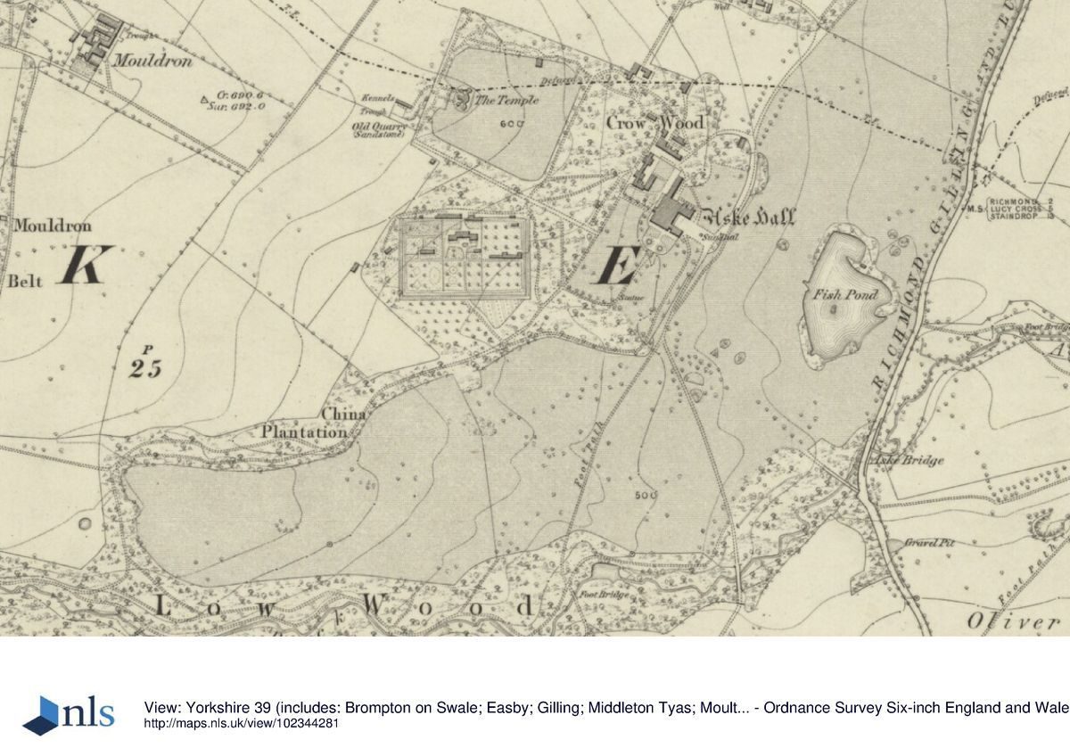
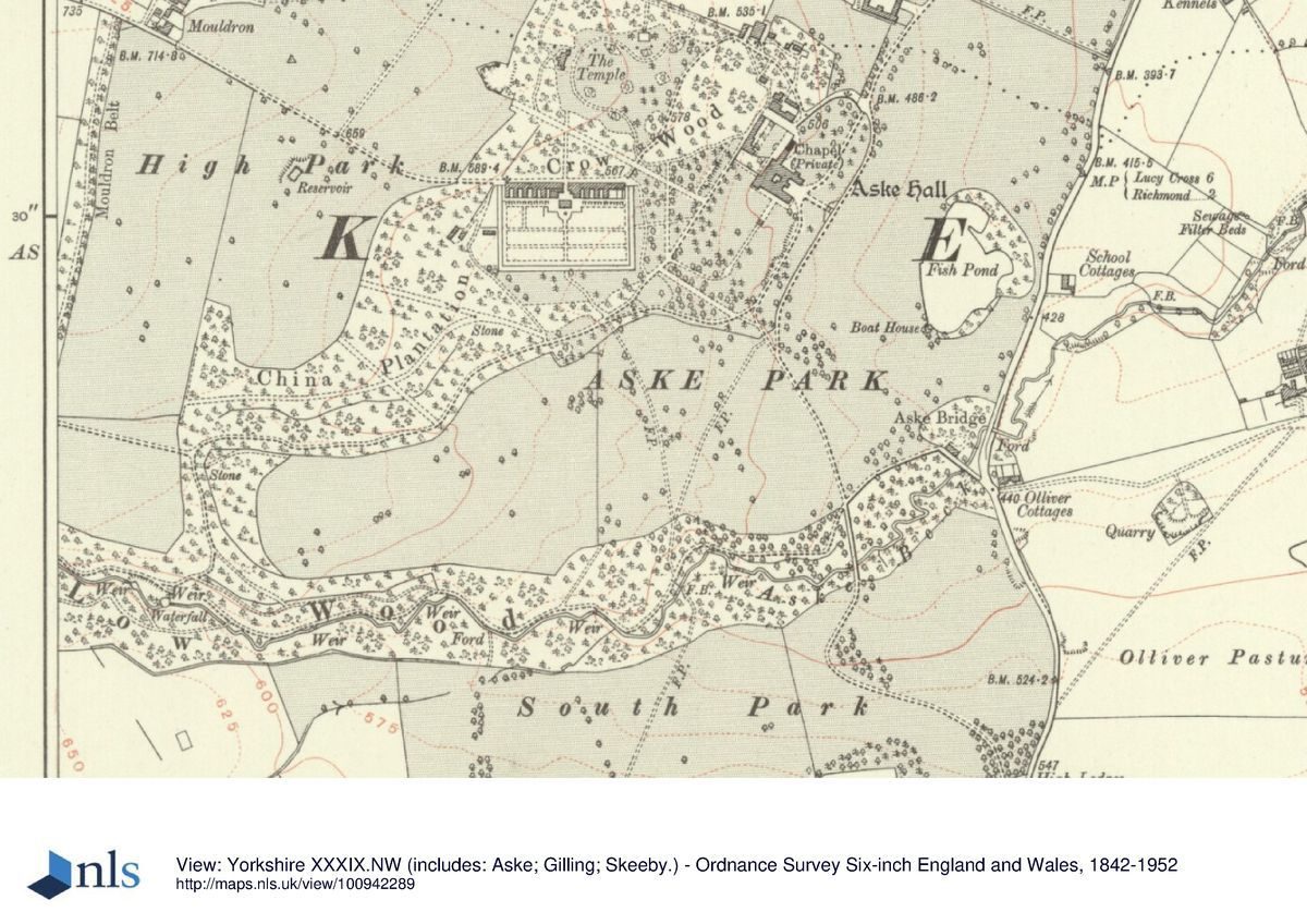
Aske Hall lies c 1.5 km north of Richmond in a rural and agricultural setting. The c 165 ha site is on land which rises northwards from the valley of the Aske Beck, which runs along the south side of the site. Gilling Road forms the eastern boundary. Fences divide agricultural land from the southern boundary which follows the wooded edge of the valley of the Aske Beck for most of its length. The south-western boundary is formed by Washton Road and by a belt of trees called Mouldron Belt. The north-western boundary includes a drive through Mouldron Plantation, and walls and fences divide the northern boundary from agricultural land.
Entrances and Approaches
Low Lodge lies at the north-east tip of the site beside a gate with rusticated stone gate piers leading to a drive which curves south-westwards to the stables from which point it continues as a lime avenue. The drive divides, with one branch running north and then west to the rear (north-west) side of the Hall and the other continuing south-west to a set of rusticated gate piers and gates (mid-late C19, listed grade II) leading to the gardens and the south-east side of the Hall. The 1761 map shows this approach as an avenue which followed a route running directly south-west from an entrance to the west of Low Lodge and continuing to a turning circle on the south-east side of the Hall. The curving route and present entrance is shown on the1813 map and was possibly laid out to Brown's design.
At the south-east corner of the site High Lodge has an entrance in the form of a triumphal arch with wrought-iron gates (mid-late C19, listed grade II). A drive follows a curving route north-west, crossing the Aske Beck via a stone bridge, before continuing to a set of rusticated stone gate piers and gates (mid-late C19, listed grade II) and running on to the south-east side of the Hall. This route is first shown on the 1813 map. Brown was asked to advise on 'a bridge and the head of water where the new road was to go over' (Stroud 1975), presumably referring either to this approach or possibly to Aske Bridge (listed grade II), a late C18 bridge with pilaster buttresses and shell niches which carries Gilling Road over the Beck on the east side of the site.
An entrance on the east side of the site south of Aske Bridge on Gilling Road leads to a drive which runs first north-west before curving westwards to join with the route from High Lodge. The 1727-58 and 1761 maps show this entrance and the drive leading from it, shown as a double avenue on the 1761 map, which ran directly north-west to the south-west side of the Hall, and can be discerned as a faint line in the park. At the north-west tip of the site West Lodge is a C19 building off Washton Road and a drive leads from it to the kitchen garden before continuing to the north-west side of the Hall. This route is shown on the 1913 OS map and was probably created as part of a phase of post-1857 improvements to the estate.
Principal Building
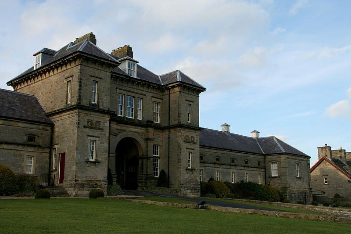
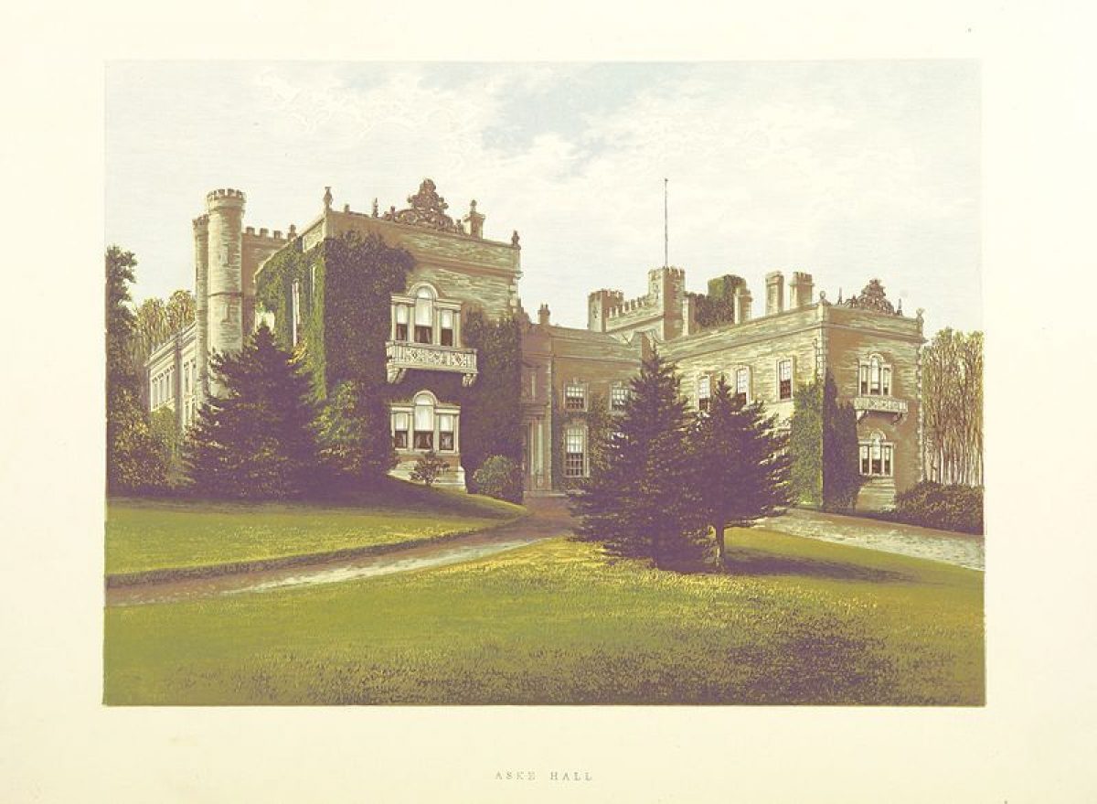
Aske Hall (listed grade I) has at its core a C15 pele tower and a C16 hall. The wings date from the C17 and the building was remodelled in the early(mid C18. C19 alterations were undertaken by Ignatius Bonomi, and further work was carried out by Claude Phillimore in the C20. A wing (listed grade II*) which extends north-eastwards from the north-east corner of the building contains a private chapel, and on the north-west side of this there is a courtyard. This originated as a stable block of 1763 designed by John Carr and was converted in 1887. The building is in use as a private residence (1998).
A C19 stable block (Thomas Oliver, listed grade II) is ranged around a courtyard c 300m north-east of the Hall.
Gardens and Pleasure Grounds
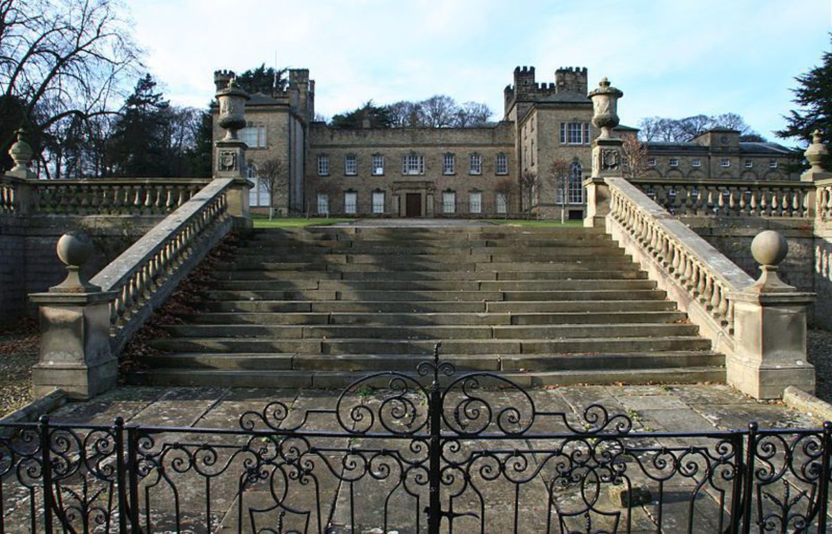
On the south-east side of the Hall there are lawns which are divided from the park by a ha-ha wall which has a balustrade and central mid-late C19 stone steps leading down into the park. There are views over the park to a lake with a temple on its far shore (see below) to rising land beyond. The 1727-58 and 1761 maps show a terrace with a bastion aligned with the front of the Hall which seems to coincide approximately with the line of the ha-ha wall.
Some 50 m north of the Hall a terraced walk runs from the courtyard on the north side of the building south-west for a distance of c 200 m, as shown on the 1761 map, from which point it continues as a path into woodland south-west of the kitchen garden called China Plantation. Some 70 m north-west of the Hall, on the north side of the terraced walk, there is a summerhouse (listed grade II) in the form of a temple which was probably built for Sir Lawrence Dundas c 1770. Immediately south-east of the building there is a late C20 terraced garden. The 1727-58 map shows a series of enclosures around the Hall, most of them planted with trees.
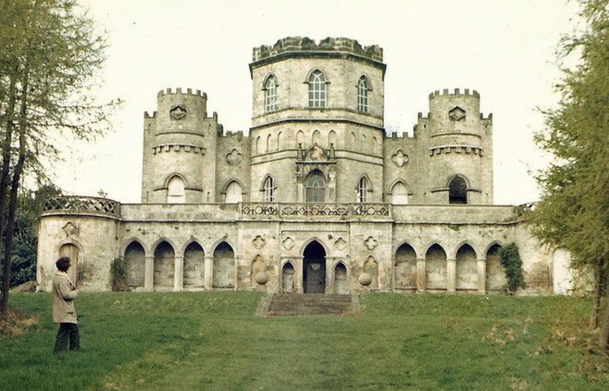
Immediately north and north-west of the terraced walk, on land which rises to the north-west, there is an area of scattered trees and shrubs called Crow Wood, shown as woodland on the 1727-58 map. Some 300 m north-west of the Hall the Temple (listed grade II*) lies on a platform at the head of a grassy slope where a vista has been cut through the trees.
The building is shown on the 1761 map but not on that of 1727-58. It is known that Sir Conyers D'Arcy obtained a preliminary sketch for the building from William Kent, and a drawing of the executed design suggests that this too might be by Kent, who died in 1748. It is probable that Daniel Garrett supervised its construction in the period c 1745-51, when he was active in the area and before records of him cease in the mid 1750s (see Leach in CL 1974 for a discussion of the relationship between Garrett and Kent in the execution of this building).
There is some evidence in the character of the masonry to suggest that it was built in two stages, with the flanking turrets possibly being later additions. The Temple is shown on the 1761 map standing at the head (north-west end) of a rectangular area marked Coney Garth, a clearing with avenues on each side apart from the north-west side behind the Temple. The avenue on the south-west side survives as a vista through the trees, the only survivor of axial paths or vistas shown extending into Crow Wood from each side of Coney Garth.
Pleasure grounds alongside Aske Beck are reached from a system of paths through China Plantation into Low Wood, through which the Beck runs. There are also paths running south from the garden across the park which join the beck-side path c 500 m south-west of the Hall. The Beck follows a winding course in a narrow valley and runs over a series of cascades starting at a point c 1.2 km south-west of the Hall. A circular stone-lined pool c 1.1km south-west of the Hall is marked on the 1761 map, but little trace survives of two pools shown to the west of it.
The Beck continues over more cascades, which are generally characterised by smooth flowing lines rather than rocky or broken effects. It is crossed by a number of footbridges, some with stone arches. Paths alongside the Beck continue to a point c 500 m south of the Hall where a depression marks the site of a pond shown on the 1761 map and on the 1857 OS map. Traces of a sluice diverting water away from the main course of the Beck can be seen, and this is shown running north-eastwards for a distance of c 300 m towards the lake on both maps.
Kitchen Garden
The walled kitchen garden lies c 200 m west of the Hall. A building c 20 m south of the north wall probably originated as an orangery and was converted into gardeners' cottages probably in the late C19/early C20. It is shown flanked by wings on the 1761 map and it retains the same plan on the 1857 OS map, but the 1913 OS map shows it shorn of its wings. There are glasshouses against the north wall and a terraced walk runs parallel to them on the east side of the garden. The outlines of the garden are shown on the 1761 map with the legend 'Wheat Close now made into the Kitchen Garden and plantations'.
Park
The south-east side of the Hall overlooks open grassland with scattered clumps of oak. A lake lying c 300 m south-east of the Hall is of oval shape with an irregular eastern shoreline sheltered by trees. A folly in the form of a temple (c 1770, listed grade II) lies on a promontory close to the north end of the east shore. The lake is shown on the 1761 map when it had a fairly regular shoreline and a stepped cascade on the south side fed by a canal running south, with water supplied from the sluice running from the Aske Beck. The 1813 map shows the modified irregular outline of the lake overlaid upon what appears to be a tracing from the 1761 map, complete with canal and cascade. A small island is marked, which is also shown on the 1857 OS map but not on that of 1957. The canal and cascade are not shown on the 1857 OS map.
The south-east part of the park, south of the Beck and Low Wood, is open grassland with clumps of oak trees on each side of the south drive. It is shown in approximately its present form on the 1813 map and was possibly laid out to Brown's design as part of the landscaping of the south approach.
The parkland west of the south drive and south of China Plantation is grassland with clumps and drifts of trees. The 1857 OS map (the map of 1813 does not record details of planting) suggests that these could be thinned remnants of two avenues shown on the 1761 map running south-west through the parkland. The southernmost avenue, shown on the map as a single avenue punctuated with quincunxes, was in alignment with the south-east terrace in front of the Hall and in turn with the avenue approach from the north-east side of the site. This part of the park is sheltered on the south side by Low Plantation, shown as a narrow band of trees on the 1727-58 map, and as a more substantial area of planting on the 1761 map, conforming broadly with the present pattern of planting. To the north is China Plantation, shown on the 1761 map as a thin band of planting. On the north-west side of the site there is an area of grassland, arable and paddocks called High Park which is sheltered on its west side by Mouldron Belt, as shown on the 1857 OS map. This area is shown as fields on the 1761 and 1813 maps. A belt of beech trees shelters the northern boundary.
Olliver Ducket (listed grade II) is a castellated eyecatcher which lies c 1.4 km south-east of the Hall on rising ground outside the park. It was probably built in the mid C18 by Sir Conyers D'Arcy, perhaps by Daniel Garrett (see Leach, CL 1974).
Maps
- J Colbeck, A Map of the Lordship of Ask in the North Riding of the County of York Surveyed for the Honble Sr Conyers Darcy, nd (ZNK M1/1), (North Yorkshire Record Office)
- G Jackson, A Plan of the Lordhip of Ask belonging to the Right Honble Earl of Holdernesse, 1761 (ZNK M1/3), (North Yorkshire Record Office)
- Map of Richmond, Aske and the environs, 1813 (ZNK M1/6), (North Yorkshire Record Office)
- OS 6" to 1 mile: 1st edition published 1857, provisional edition 1957
- OS 25" to 1 mile: 2nd edition published 1913
Description written: November 1998
Amended: March 1999
Register Inspector: CEH
Edited: October 1999
- Visitor Access, Directions & Contacts
- History
The following is from the Register of Parks and Gardens of Special Historic Interest. For the most up-to-date Register entry, please visit The National Heritage List for England (NHLE):
16th - 17th Century
The estate was owned by the de Aske family in the medieval period and passed by marriage to the Bowes family c 1522. It passed to Sir Talbot Bowes in 1627 who sold it to his maternal uncle, Sir Thomas Wharton.
18th - 19th Century
The Whartons retained it until 1727 when it was sold to Sir Conyers D'Arcy for whom an undated estate map was drawn up at some point before his death in 1758. Another map dated 1761 was drawn up for Sir Conyers' heir Lord Holderness probably as a preliminary to the sale of the estate in 1763 to Sir Lawrence Dundas. Lancelot Brown (1716-83) was consulted by Dundas in c 1770 and a map of 1813 gives an indication of the executed scheme, though little is known about the contract and it is not possible to be certain that the changes in the landscape between 1761 and 1813 were necessarily to Brown's design. Dundas' son was created first Earl of Zetland in 1838, and after the death of the second Earl in 1873 it passed to a nephew, also Lawrence, who was created Marquess of Zetland in 1892.
20th - 21st Century
The estate continued in the family and remains in private ownership (1998).
Period
18th Century (1701 to 1800)
- Associated People
- Features & Designations
Designations
The National Heritage List for England: Register of Parks and Gardens
- Reference: GD2058
- Grade: II*
- Key Information
Type
Park
Purpose
Ornamental
Principal Building
Domestic / Residential
Period
18th Century (1701 to 1800)
Survival
Extant
Hectares
165
Civil Parish
Aske
- References
References
- {English Heritage Register of Parks and Gardens of Special Historic Interest}, (Swindon: English Heritage, 2008) [on CD-ROM] Historic England Register of Parks and Gardens of Special Historic Interest
- Stroud, D., {Capability Brown} (London: Faber, 1975), pp. 215-6 Capability Brown
- Pevsner, N., {The Buildings of England: Yorkshire The North Riding} (Harmondsworth: Penguin, 1966), pp. 65-6 The Buildings of England: Yorkshire The North Riding
- pp 834-7 Country Life 156
- pp 6-9 Richmondshire Architecture
- Related Documents
-
CLS 1/542
Historic Landscape Restoration Plan - Digital copy
Scott Wilson - 2004
-
CLS 1/542