Introduction
Ashton Gardens is a public park, laid out between 1914 and 1916 to a design by F. Harrison of Lytham St Annes. Pulham and Sons carried out the construction. The gardens, which occupy about 5 hectares, retain many original features, including a ladies' bowls pavilion and a war memorial.
Terrain
Ashton Gardens are situated on the north side of the centre of St Annes on land which partially retains the form of sand dunes.The following is from the Register of Parks and Gardens of Special Historic Interest. For the most up-to-date Register entry, please visit The National Heritage List for England (NHLE):
Public park laid out 1914-16 to a design by F Harrison of Lytham St Annes and by Pulham & Son which retains most of its original features.
Location, Area, Boundaries, Landform and Setting
Ashton Gardens are situated on the north side of the centre of St Annes on land which partially retains the form of sand dunes. The c 5ha park is walled and boundaries are formed by Beach Road to the north, private gardens backing from St Andrews Road North to the east, St George's Road to the south and Clifton Drive West and St George's Square to the west.
Entrances and Approaches
There are two main entrances. On the south side, off St George's Road, the entrance is fronted by a forecourt with a central flower bed. A pair of lodges flank an elaborate iron screen with gate piers and gates. The entrance is aligned with Garden Street so that it can be seen at the end of the street from St Annes Road West, which is one of the town's principal thoroughfares. This was the original entrance to St George's Gardens and it is shown, with the lodges, on the 1894 OS map. The other main entrance is on Clifton Drive North, on the west side of the site, where there are stone gate piers and ornamental gates which frame views of a war memorial (listed grade II) which is positioned close to the centre of the park. This entrance and land immediately to the east was outside the boundaries of St George's Gardens and was occupied by a timber yard, shown on the 1911 OS map, which was acquired by the council at the time of the purchase of the Gardens. Secondary entrances from Beach Road and St George's Square have stone gate piers.
Gardens and Pleasure Grounds
The park consists of three distinct areas. A strongly formal area on the west side of the site relates to approaches to and views of the war memorial; bowling greens and sports areas are situated to the east, and pleasure grounds to the north.
The entrance from St George's Road leads to a path which runs north between formal beds. Ashton Pavilion, shown on the 1932 OS map and destroyed by fire in 1977, was formerly situated immediately north of the entrance. On each side of the entrance lodges there are sunken areas. That to the north is in use as a bowling green, as shown on the 1932 map. The corresponding area to the south marked 'Tennis Ground' on the 1932 map is currently (1997) grassed and used as a general recreation area.
On the north side of the bowling green there is a late C20 café and on the east side there is a pavilion, shown on the 1932 map. A second bowling green, also with a pavilion, lies immediately north-east of the first. To the west of this an area marked 'Tennis Ground' on the 1932 map is divided into a fenced children's playground and playing fields.
The entrance from Clifton Drive North leads to a path running east as an avenue which was planted in the mid or later C20 and is not shown on the 1932 map. Some 80m east of the entrance are two circular beds with stone retaining walls positioned on either side of the path and reached from stone steps which lead down from each side of the path, as shown on the 1932 OS map. At the east end of the path a flight of stone steps leads up to a platform on which is a war memorial of 1923 which dominates the west side of the park. It consists of a tall pier of white granite supported by bronze statues, surmounted by a hemispherical plinth with a bronze statue of a figure with arms outstretched in supplication.
To the east of the war memorial paths which link with the main path from the St George's Road entrance lead to the northern part of the site which is bordered by steep wooded banks screening it from view, in contrast to the open character of the other parts of the park. The pattern of banking is as indicated on the 1911 OS map. A path leads up the bank on the west side of this area and overlooks a circular lawn to the west, shown on the 1932 OS map, which is laid out with geometric flower beds. The path continues northwards to the top of the bank and leads over two rustic cast-iron bridges spanning gaps in the banking. On the west side of this route there is a rectangular area which has been laid out in the late C20 in oriental style with large boulders and exotic shrubs. Immediately to the east of the bank there is a rose garden of rectangular shape with apsidal north and south ends and a central square lily pond, as shown on the 1932 OS map. Radial paths lead from the pond replacing a gridiron pattern of paths shown in 1932. At the south end there is a pedimented niche with a drinking fountain and a plaque commemorating Lord Ashton's gift. The garden, which was planted with 6000 rose trees when it was laid out, is sheltered by wooded banks on all but the north side where there is a hedge and an entrance with stone gate piers.
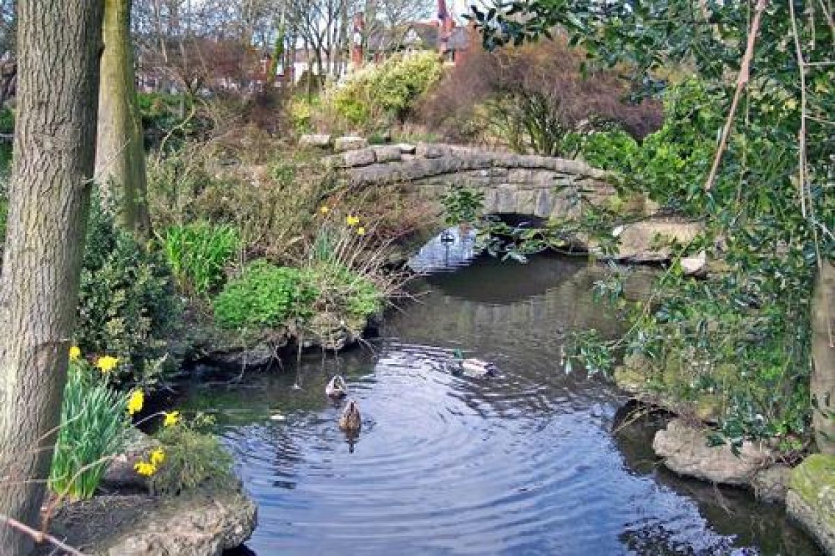
A path leads north from the rose garden and connects with a system of paths which leads around a rock and water garden constructed by Pulham & Son whose scheme was adopted in 1914. More than 500 tons of weather-worn rock from Grange was used and the rocks are arranged to simulate natural geological strata. A lake with an irregular shoreline was fed by a cascade and waterfall at its southern end. Much of the rockwork relating to these features survives, but the water is no longer flowing. There is banking around the perimeter formed from the spoil from the lake which echoes the banking around the rose garden and serves to create different scenes and views of the lake as the path system is followed.
Pulham's plan was reproduced in an article on the Gardens which appeared in the Lytham St Annes Express on 18 September 1914. The 1932 OS map shows the lake in similar but not identical form, and it currently (1997) occupies a slightly larger area having been extended on the north-east side. There are a number of mature trees in this part of the park and some may relate to the St George's Gardens phase since the article in the Express states that the intention was to retain existing planting where possible.
Glasshouses of late C20 date and a maintenance area are situated on the east side of the park, in an area c 200m north-east of the St George's Road entrance which is shown as a yard with a glasshouse at its northern end on the 1932 OS map.
Maps
- OS 6" to 1 mile:
- 1st edition published 1894
- 2nd edition published 1912
- 1938 edition
- OS 25" to 1 mile:
- 2nd edition published 1911
- 1932 edition
Description written: December 1997
Register Inspector: CEH
Edited: May 2000, April 2023
- Visitor Access, Directions & Contacts
Telephone
01253 658443Website
https://www.discoverfylde.co.uk/Access contact details
Open and free to all visitors.
- History
19th Century
Ashton Gardens were originally named St George's Gardens when they were first created in the late 19th century. The garden was rectangular in design and contained lawns, flower beds, ponds and avenues of trees. They were designed by the landscape gardener E. Thomas.
The gardens were originally created as a commercial enterprise to attract visitors, but the company that owned them had problems in making them cost-effective. The gardens were offered to a forerunner of the local council to purchase because otherwise the land would have been built over.
Unfortunately the two parties had many disagreements about what to do with the land. When the owning company put restrictions on the sale of the land so that the council could not alter the original design, the council approached Parliament. This action resulted in a referendum being held in 1914 to determine whether the local population wanted the council to buy the gardens or not. At the last minute Lord Ashton stepped in and offered to buy the gardens for the town at a cost of £21,350. This offer was accepted.
Lord Ashton then later purchased a further 1 hectare (2.5 acres) of surrounding land. This expanded the gardens from 4 hectares (12 acres) to 5 hectares (12.5 acres).
Ashton re-landscaped and re-named the gardens. They were opened to the public for the first time on 30 June 1916.
20th Century
During the later 20th century the gardens were a cause of further debate, when the council proposed to sell off parts of the gardens. These plans were opposed by the Supporters of Ashton Gardens.
21st Century
In June 2007 the council received a grant of almost £1.5 million, which it plans to use to restore and remodel the gardens.
The following is from the Register of Parks and Gardens of Special Historic Interest. For the most up-to-date Register entry, please visit The National Heritage List for England (NHLE):
Gardens called St George's Gardens were laid out on the site in 1874-5 by E Thomas, a landscape gardener from Aughton, for a subsidiary of the St Annes on Sea Land and Building Company.
In 1896 they were offered to the local council for £12,000, who turned the offer down. The lease was taken over by O J Porritt and the Gardens were offered to the council again in 1912 when Porritt applied to build on them. The council was reluctant to spend the sum of money required as it would have necessitated raising rates, so a poll to decide the matter was arranged.
On the eve of the poll Lord Ashton donated more than £25,000 so that the land could be purchased and improvements made. A competition for the design was organised and won by local man F Harrison in January 1914. Work on the renamed Ashton Gardens started soon afterwards and the council resolved to continue it despite the outbreak of war.
The Gardens were opened in 1916.
Period
- 20th Century (1901 to 2000)
- Early 20th Century (1901 to 1932)
- Associated People
- Features & Designations
Designations
The National Heritage List for England: Register of Parks and Gardens
- Reference: GD4035
- Grade: II
The National Heritage List for England: Listed Building
- Reference: war memorial
- Grade: II
Features
- Bowling Green Pavilion
- Description: The Ladies Bowls Pavilion.
- Earliest Date:
- Latest Date:
- Pulhamite
- War Memorial
- Key Information
Type
Park
Purpose
Ornamental
Principal Building
Parks, Gardens And Urban Spaces
Period
20th Century (1901 to 2000)
Survival
Extant
Hectares
5
Open to the public
Yes
- References
References
- {English Heritage Register of Parks and Gardens of Special Historic Interest}, (Swindon: English Heritage, 2008) [on CD-ROM] Historic England Register of Parks and Gardens of Special Historic Interest
- Brown, K., (1992), pp 38-40 Lytham and St Annes: The Reluctant Resorts
- (1919-20), pp 22-3 St-Annes-on-Sea Guide
- 18 October 1912; 11 September 1914; 18 September 1914; 30 June 1916 Lytham St Annes Express