
Introduction
Ampthill is an 18th-century landscape park. The immediate area of 1.75 hectares around Park House is now separated from the main parkland.
Terrain
The southern part of the site is bisected west to east by the Ampthill Ridge, part of the Greensand Ridge, which falls gently to the south boundary and steeply to the north to the flat land of the Bedford Plain in the northern half of the site.The following is from the Register of Parks and Gardens of Special Historic Interest. For the most up-to-date Register entry, please visit The National Heritage List for England (NHLE):
Location, Area, Boundaries, Landform and Setting
A C17/C18 country house surrounded by a landscape park by Lancelot Brown, c 1771-2.
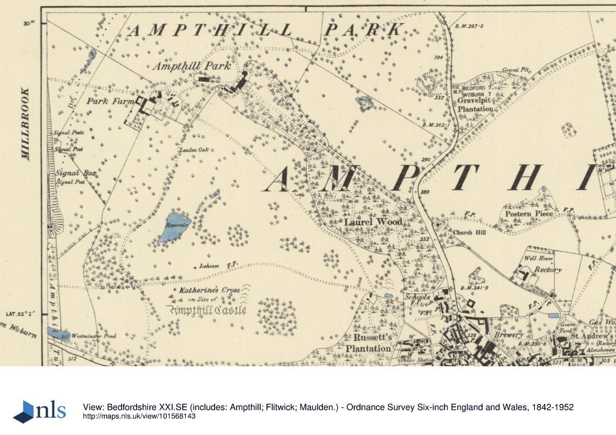
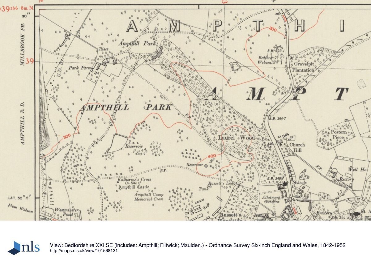
Ampthill Park lies 10km south of Bedford, at the north-west corner of Ampthill town. The c 140ha site is bounded to the south by the old Woburn to Ampthill road, with the site of the medieval Little Park and Cooper's Hill south of this, to the east by the Bedford to Ampthill road, and to the north-west and north by agricultural land, with the mainline railway forming the south-west boundary. The southern part of the site is bisected west to east by the Ampthill Ridge, part of the Greensand Ridge, which falls gently to the south boundary and steeply to the north to the flat land of the Bedford Plain in the northern half of the site. The setting is largely agricultural and wooded, with the town of Ampthill to the south-east, the village of Millbrook to the west, and the Houghton House estate to the east.
Entrances and Approaches
The main approach to the house is via the east drive, entering the park 600m north-east of the house off the Bedford to Ampthill road, curving south-west through the park with broad views to the north and west. A spur off the main drive turns south 50m north of the house, curving up a steep slope to arrive at a gravel sweep by the tall flight of broad stone steps on the north-west front of the house. This front overlooks a sloping paddock with a stone statue of a hound on a pedestal (late C18, listed grade II) at the top, south end and two flanking clumps of trees adjacent to the drive, possibly the remains of an C18 avenue which ran north-west from the house. The drive then curves down to the west, returning to join the main drive as it continues on to Park Farm, 300m west of the house.
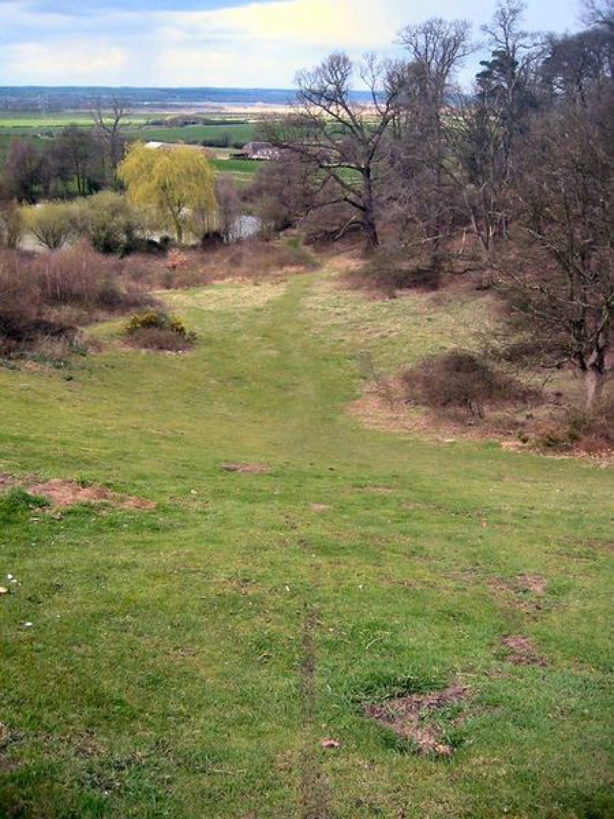
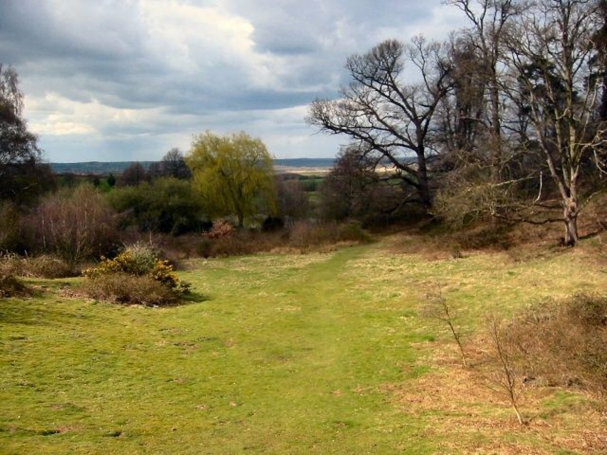
The remains of a further, largely straight drive, now known as Lime Walk, enters off the Bedford road 650m south-east of the house. Its route cuts through the steeper gradients within Laurel Wood to create a smooth gradient up through the Wood and, formerly, through the pleasure grounds, to the south-east front of the house. Its course through the pleasure grounds is now largely lost. Gordon's map of 1736 shows this as the main drive.
A third drive, thought to be the major drive through the park as established by Brown (Bedfordshire Magazine 1972), enters 900m south of the house off the Woburn road on the south boundary, passing the site of a lodge demolished in the late C20. The drive curves north up the hillside to the top of the ridge, with views from the incline to the west and south-west towards distant woodland, and, at the summit, sudden spectacular views north across the reservoir and house into the Bedford Plain towards Bedford, as well as a view of the plateau site of Ampthill Castle, now marked by the Katherine Cross. The drive descends steeply around the edge of a wide, bowl-shaped feature containing the reservoir, today (1997) becoming an agricultural track as it crosses arable land to join the west arm of the east drive up to the north-west front of the house.
Principal Building
The house, built for John, first Baron Ashburnham c 1694 (listed grade II*) lies towards the centre of the park, sited on a rise at the north-west end of a shoulder of land extending from the Ampthill Ridge, overlooking the Bedford Plain to the north, with the Ridge rising to the south. Built of brick, the three-storey main block with mansard roof is flanked by smaller side blocks, originally connected by arcading. Sir William Chambers remodelled the house 1769-71, encasing the whole in stucco (since removed), and building pilastered wings to connect the main block with the side blocks. The stables, formerly 100m west of the house, have completely gone.
Gardens and Pleasure Grounds
The informal, enclosed pleasure grounds lie on the south-east, garden front of the house, extending 300m south-east to merge with Laurel Wood, and bounded to north and south by the intermittent remains of a brick ha-ha. Together with Laurel Wood, they occupy the shoulder of land extending north-east from Ampthill Ridge, with the house situated at the north-west tip.
The area close to the house is laid largely to lawn with specimen trees, the ground falling sharply to north and south from the broad, level, central spine, with views from the slopes across the park to the south, and the park and Bedford Plain to the north. This area, subdivided into three by hedges and low fences, is divided from the south-eastern section by a fence (C20) situated 100-150m south-east of the house. Beyond the fence the pleasure grounds contain many more mature trees, including the remains of a short lime avenue 200m south-east of the house, lying adjacent to, and to the north of, the main axis of the Lime Walk drive. This area contains further mature limes, beeches and yews, with scrub undergrowth. A narrow central path on the central spine links the fence with the remains of a gateway 300m south-east of the house, marking the formal division between Laurel Wood and the enclosed pleasure grounds.
Formerly (OS 2nd edition 1901), when Lime Walk drive continued north-west from Laurel Wood, it ran through the centre of these wooded pleasure grounds, with two informal, curving paths running parallel to, and either side of, the straight drive. The wooded areas thinned out towards open areas closer to the house, and eventually all three routes converged on the central block of the south-east front of the house, with a path running the length of the front.
Laurel Wood, with Lime Walk drive running along its northern boundary, appears to be an extension of the pleasure grounds, with various informal paths within the woodland which emerge on the boundary with the south park. Its wooded character is similar to that of the wooded south-east section of the enclosed pleasure grounds.
Park
The park, which surrounds the house, is divided into two by a C20 fence line which runs from west to east. Gordon's map of 1736 shows the house and park, surrounded by a paled fence, extending over both sides of the Ampthill Ridge, falling some way into the Bedford Plain to the north. The northern half, now largely arable farmland with the consequent loss of most of its park trees, is sited on land sloping gently down to the Plain, while the southern half which straddles the ridge is still largely pasture, bisected by the woodland spine of Laurel Wood and Russett's Plantation. The southern half contains many clumps of trees, perhaps planted by Brown, and some trees said to predate Brown's work (Bedfordshire Magazine 1972).
Hill spurs, planted to emphasise their smooth contours, run from the Ridge down to the south boundary with, at the bottom, several late C20 sports pitches and clubhouses in a line running parallel with the belt which runs the length of the south boundary, merging into Russett's Plantation at the east end. Here lies Russett's Lodge, 800m south-east of the house, on the boundary between the park and the Plantation. It is a small, late C17 brick building, remodelled and enlarged by William Chambers who gave it a classical, pedimented façade on its main, north front. The Katherine Cross (listed grade II) stands in a prominent ridge-top position 700m south of the house, a tall stone cross of Gothic design erected by James Essex in 1773 for the second Earl of Upper Ossory, to mark the site of Ampthill Castle. The cross, sited on a plateau with views north towards the house and Bedford Plain, bears a shield of England impaling Aragon, and an inscription by Horace Walpole commemorating Katherine of Aragon's residence: 'The mournful refuge of an injured Queen' (VCH). The Ampthill Camp Memorial Cross lies 100m south-east of the Katherine Cross, built in similar style and erected by the Duke of Bedford after World War I to commemorate the use of the park as an army camp.
The railway has been taken as the western boundary of the area here registered, but formerly the park extended west of the railway line, as far as the village of Millbrook (OS 1st edition published 1881). Views still extend west from the park over the higher ground on which this former parkland lay.
Kitchen Garden
There are no obvious remains of a kitchen garden, although several glasshouses are shown inside an enclosure adjacent to the east of Park Farm on the OS map of 1901.
Maps
- T Jefferys, The County of Bedford, 1765
- A Bryant, Map of the County of Bedford, 1826
- Ampthill Park, 1808 (Bedfordshire Record Office)
- OS 6" to 1 mile:
- 1st edition published 1881
- 2nd edition published 1901
- 3rd edition published 1926
- OS 25" to 1 mile: 1st edition published 1880
Description written: September 1997
Amended: April 1999
Register Inspector: SR
Edited: April 1999
- Visitor Access, Directions & Contacts
Telephone
07710 829 327Access contact details
This is now a public park, open daily.
For more detailed visitor information visit the Ampthill Town Council website.
Ampthill Great Park is owned and managed by Ampthill Town Council, assisted by The Greensand Trust.
Directions
West of the A6, north of the A527.
Owners
Ampthill Town Council
66 Dunstable Street, Ampthill, Bedfordshire, MK45 2JS
- History
The following is from the Register of Parks and Gardens of Special Historic Interest. For the most up-to-date Register entry, please visit The National Heritage List for England (NHLE):
15th - 17th Century
Ampthill Great Park, originally a deer park, surrounded Ampthill Castle, which was built in the early C15 by Sir John Cornwall, lord of Ampthill Manor; Ampthill Little Park lay south of the Ampthill to Woburn road. Having become royal property, the castle and parks were used by Henry VIII, who paid frequent visits between 1524 and 1532, and by Katherine of Aragon in the early 1530s during the divorce proceedings with Henry. The castle was ruinous by the end of the C16 (VCH) and the present Park House was built in the late C17 to replace the Great Lodge, built in the C16 for Sir Francis Bryan.
18th Century
In 1769 the second Earl of Upper Ossory employed Sir William Chambers (1723-96) to remodel the house, and following this work, employed Lancelot Brown (1716-83) to landscape the park from 1771-2, for which Brown received £2396 (Stroud 1975). Horace Walpole visited Ampthill, corresponding regularly with Lady Ossory, and advised on the erection of the Katherine Cross in 1773, contributing the inscription.
19th Century
The second Earl lived at Park House until his death in 1818. In 1837 it was leased to Sir James Parke, later Lord Wensleydale, whose family remained as tenants until his widow's death in 1879, the estate having been bought by the Duke of Bedford during this period.
20th - 21st Century
The house was occupied by the army during World War II, following which it was sold to Bovril Limited, in 1955 becoming a Cheshire Home. It is now divided into several domestic units.
Period
- 18th Century (1701 to 1800)
- Late 18th Century (1767 to 1800)
- Associated People
- Features & Designations
Designations
The National Heritage List for England: Register of Parks and Gardens
- Reference: GD1334
- Grade: II
Style
English Landscape Garden
Features
- House (featured building)
- Now Flats
- Description: The present Park House was built in the late-17th century and re-modelled in 1769. It has since been divided into several domestic units. Built for John, first Baron Ashburnham c 1694 (listed grade II*)
- Earliest Date:
- Latest Date:
- Sculpture
- Description: The Katherine Cross. (listed grade II) stands in a prominent ridge-top position 700m south of the house, a tall stone cross of Gothic design erected by James Essex in 1773 for the second Earl of Upper Ossory, to mark the site of Ampthill Castle.
- Earliest Date:
- Woodland
- Description: Laurel Wood
- Ha-ha
- Description: Brick ha-ha - intermittent remains
- Stables
- Description: The stables, formerly 100m west of the house, have completely gone.
- Statue
- Description: Sloping paddock with a stone statue of a hound on a pedestal (late C18, listed grade II) at the top.
- Steps
- Description: Tall flight of broad stone steps on the north-west front of the house
- Key Information
Type
Park
Purpose
Recreational/sport
Principal Building
Parks, Gardens And Urban Spaces
Period
18th Century (1701 to 1800)
Survival
Extant
Hectares
140
Open to the public
Yes
Civil Parish
Ampthill
- References
References
- {English Heritage Register of Parks and Gardens of Special Historic Interest} (Swindon: English Heritage, 2008) [on CD-ROM] Historic England Register of Parks and Gardens of Special Historic Interest
- Stroud, D {Capability Brown} (1975) p 215 Capability Brown
- Land Use Consultants {Ampthill Great Park Management and Maintenance Plan} (2014) Ampthill Great Park Management and Maintenance Plan
- (1927-8), pp 69-70 The Walpole Society 16
- Collett-White, J, (ed), (Bedfordshire Historical Record Society 1995), pp 12-15 Inventories of Bedfordshire Country Houses, 1714-1830
- Vol 13 (autumn 1972), pp 241-6 Bedfordshire Magazine
- Related Documents
-
CLS 1/590
Ampthill Park: A report on the historic landscape (Draft) - Hard Copy.
Debois Landscape Survey Group - 2002
-
CLS 1/592
Ampthill Park: A report on the historic landscape (Draft): Appendices Part2 - Hard Copy.
Debois Landscape Survey Group - 2002
-
CLS 1/591
Ampthill Park: A report on the historic landscape (Draft): Appendices Part 1 - Hard Copy.
Debois Landscape Survey Group - 2002
-
CLS 1/590