
Introduction
Althorp is a 19th-century landscape park with traces of an earlier formal layout and 20th-century gardens. The park covers about 225 hectares within a 5600-hectare agricultural estate. Gardens and landscape park with buildings and features of the C16 through to the late C20 associated with a country house.
Terrain
The house stands in the centre of its park, on low ground which rises to its north-west and south-east.The following is from the Register of Parks and Gardens of Special Historic Interest. For the most up-to-date Register entry, please visit The National Heritage List for England (NHLE):
LOCATION, AREA, BOUNDARIES, LANDFORM, SETTING
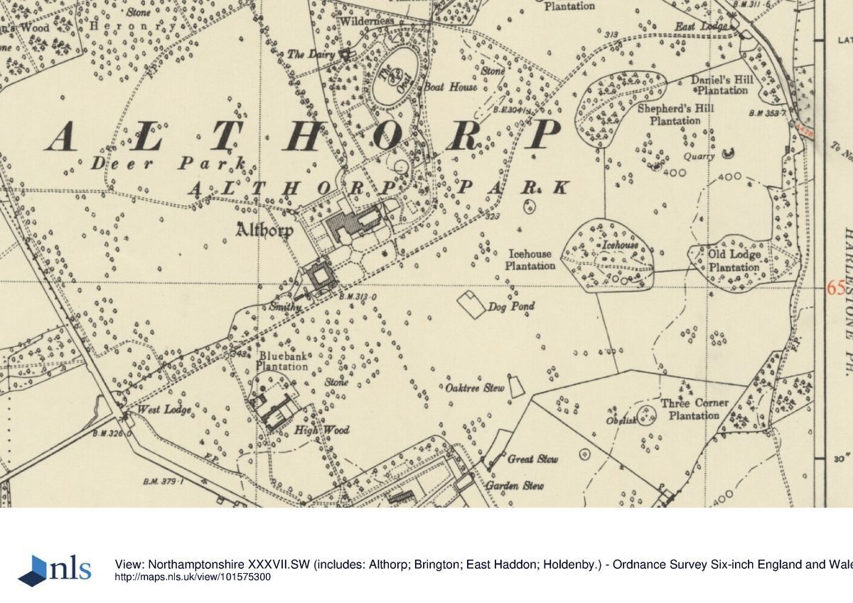
Althorp lies c 6km north-west of Northampton, on the A428 to Rugby. The house stands in the centre of its park, on low ground which rises to its north-west and south-east. The park is bounded to the north-east by the A428 and to the east by a footpath which spurs off it to Harlestone. A deliberately straightened minor road from Harlestone to Great Brington forms the south-west boundary of the park, while to the north-west the park edge touches on the minor road leading north-east from Great Brington to the A428. The area here registered is c 250ha.
ENTRANCES AND APPROACHES
The south forecourt is entered by tree-lined drives from the north-east and south-west. At the end of the former, which curves around the base of Shepherd's Hill on the line suggested by Henry Holland's plan of 1790 (see below), are the East Lodges (listed grade II), a pair of single-storey limestone ashlar buildings of c 1810 linked by iron piers, screens and gates. The West, or Brington, Lodges, at the end of a 600m long, straight drive, are single-storey ironstone buildings 'of the most basic cottage Palladian' (Mowl and Earnshaw 1985, 29) connected by iron gates on rusticated stone piers (all listed grade II). They are of c 1730 and presumably by Roger Morris (d 1749).
There are two other lodges on the park boundary. East Haddon, Swiss, or Station Lodge, a large two-storey lodge of the 1880s in the Arts and Crafts style by the local architect Joseph Mander, stands at the northernmost tip of the park, at the end of a drive past the east side of The Oval. Cotherstone Lodge (listed grade II), on the Harlestone road south-east of the kitchen garden, is of 1879(80. It was built from prefabricated concrete panels cast by W H Lascelles to a design by Richard Norman Shaw. It serves no drive.
PRINCIPAL BUILDING
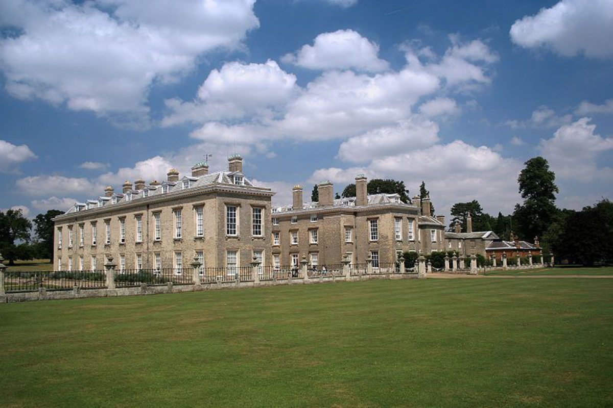
John Spencer's new house of c 1512 was constructed on a new site. The main later enlargements were in the 1630s, in the years after 1666, 1787-90, and in the 1870s. Most of what is to be seen today (listed grade I) was a product of Henry Holland's remodelling at the end of the C18, which produced a rather severe house of two storeys and an attic faced with pale buff 'mathematical tiles' (ie tiles made to look like bricks). It principally comprises a main block with an entrance court to the south flanked by projecting wings.
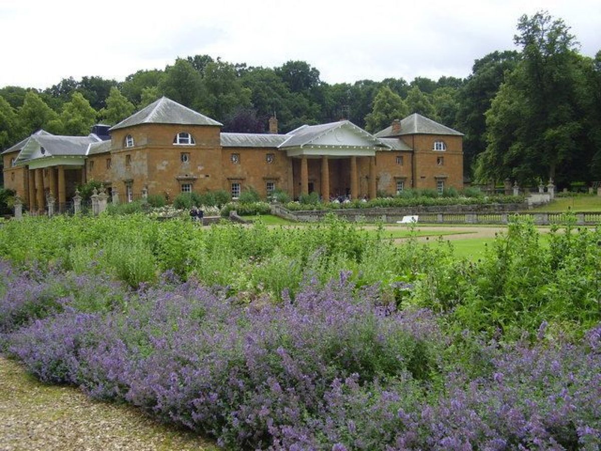
A large ironstone stable block (listed grade II*) 75m to the south-west, set around a square court and with pyramid-roofed corner pavilions and Tuscan porticos on the east and north, was added by Roger Morris in the early 1730s. The block was partly converted in 1997/8 into a museum treating the life of Diana, Princess of Wales (d 1997).
GARDENS AND PLEASURE GROUNDS
The formal gardens west and north of the house were designed in 1860 by W M Teulon.
The south, lawned forecourt, is closed to the south with wrought-iron railings on ashlar piers surmounted with urns and a low wall, all (listed grade II) designed in 1863 by W M Teulon. At the end of the South Avenue are railings and a double gate with overthrow (listed grade II), probably late C18. Inner and outer terraces run around the west and north sides of the house. The inner, defined by a low wall, is occupied by a gravel walk and flower beds. The lower, outer, terrace is much broader (c 40m), and is laid to lawn with star-shaped flower beds. Around the exterior, and dividing it from the park, is a stone balustrade which stands on a wall set in a ha-ha, again of c 1863. At the north-west corner of the garden this encompasses an octagonal bastion-like projection, slightly raised, from which there are excellent views to the house and stables and west up the shallow and broad valley of the Deer Park. Teulon was also responsible for the screen (listed grade II) east of the north front of the stables which links it with the house. The gardens include specimen trees of 1863 and later planted to mark royal visits and special family occasions.
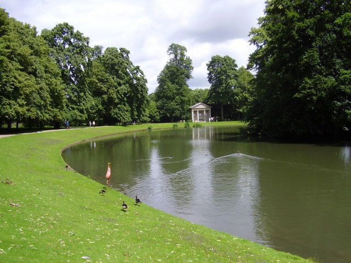
North-east of the house the formal garden gives access to the French Garden, a formal design of hornbeams, beech hedges and lime trees laid out in 1966 to a design by the seventh Earl. To the north is the Arboretum, begun in the 1820s, which now contains over 160 different species of trees. Paths lead through and around it to The Oval, a 150m long, shallow, tree-fringed oval pool with central oval island. In 1997 Diana, Princess of Wales, was buried on the island; a plinth surmounted with a memorial urn was erected at the south-west end of the island. The Oval's date is uncertain. A lake was noted in the 1730s in the 'pleasure garden'. This was presumably the same piece of water noted in 1742 by John Loveday, who saw 'a round basin of water having an eight [sic: misspelling of 'ait', an island] in the middle and communicating with a short serpentine river' (Markham 1984, 345). The Oval, its oval island and the serpentine river leading south-west from it are shown on the 1778 plan. A path, with mature lime trees along its outer edge, runs around the edge of the pool. On the bank at the north-east end of The Oval is a late C18 temple (listed grade II) with a portico of four columns, brought from the garden of the Admiralty in London by the fifth Earl. In 1997(8 this was furnished with inscriptions and other memorials to the Princess of Wales. Some 75m west of The Oval, at the north end of the Arboretum, is the Dairy Cottage (listed grade II), a single-storey ironstone building with pyramidal roof. It was designed in 1786, probably by Henry Holland, as an ornamental dairy, and the interior includes Wedgwood tiles. Originally thatched, it was reroofed in slate following a fire.
At the same time (after 1666) that the mason/architect Anthony Ellis (d 1671) was transforming the house, its surroundings were remodelled and extensive formal gardens laid out. An unsupported tradition (CL 1981, 378) attributes the design to Andre Le Notre (d 1700). It was probably at this time that the moat which had surrounded the house was drained (although left open), a formal forecourt created to the south, and gardens and terraces laid out on either side of the house within the moated area. Beyond the moat were terraced walks with ornate gateways, while to the east were extensive formal walled gardens. In 1675 John Evelyn described the 'several ample gardens furnished with the choicest fruit in England, and exquisitely kept: great plenty of oranges, and other curiosities' (cited in Anthony 1979, 19). This severe, almost symmetrical, setting and the deliberate removal of secondary or service buildings near the house was unusually sophisticated for England at this time (Heward and Taylor 1996, 53). These formal gardens, shown on Vorsterman's pre-1678 view (Harris 1979, 67) and Kip's of 1707, were perhaps removed c 1790 when the moat was infilled and the park brought up to the house. While no trace survives of the walled gardens east of the house, earthworks elsewhere presumably represent elements of the later C17 landscape. South of the house, for instance, parallel to and south-west of the existing avenue, there is a large scarp 2.5m high and almost 200m long, contrived to procure an open view from the house.
PARK
The park is roughly circular, and 1.5km in diameter. The main park, and certainly the park as defined in 1778, is surrounded by a tall, ironstone wall of 1711 (inscription on wall north of West Lodge). On the west side the registered area extends beyond this to take in the straight, recently replanted avenue to Brington church, and the area called Chinkwell Clumps. North of West Lodge the park wall drops in height, and two long clairvoies (one railed) allow views to the house. Shelter belts and plantation belts run around much of the perimeter, especially where the park boundary is followed by a road. The park is entirely permanent pasture. Extensive areas of ridge and furrow in the park are believed to represent part of the open fields of the now lost village of Althorp (see below).
The park contains many fine, mature trees, both individual parkland trees as well as in stands and avenues. Avenues of ash and oak, and originally elm, extend north-west and, most dramatically, south-east of the house to the limits of the park. Others line drives and run off at right-angles to the principal lines. Avenues were planted as part of the transformation of Althorp after 1666. Tradition (cited by Anthony 1979, 19) attributes their design to Andre Le Notre, and a modern commentator (Garden Hist 1991, 150) suggests they may have been planted c 1680. In 1742 John Loveday noted 'many fine walks between trees that arch together at the top, reminding one of Ham Walk in Surrey' (Markham 1984, 345). The formal planting, which shared the alignment of the present avenues although incorporating many more lines of trees, is shown both on contemporary views such as that published by Kip in 1709 and on a plan of 1778. Elements survive: some very old trees, now as individual parkland specimens, and banks, ditches and raised causeways on the avenues' alignments. Gradual replanting within the surviving avenues is taking place with limes and London planes.
There are inscribed stone monuments (listed grade II) in the park commemorating tree plantings of 1567, 1589, 1602, 1624, 1798, 1800, 1901 and 1917. The C16 and C17 examples stand in the north half of the park, that of 1589 within Sir John's Wood, which is surrounded by a tall, ironstone wall. Commended by John Evelyn in his Sylva, he hoped that the practice of clearly documenting such works might be followed elsewhere. The monument of 1798 is in Icehouse Clump 500m east of the house, while the three latest stand in the south half of the park. They include an obelisk of c 1906 in Three Corner Plantation, 800m south-east of the house.
On high ground close to the northern boundary of the park is the former Falconry or Standing (listed grade I), a two-storey ironstone building constructed in 1611 as an open grandstand from which the hawking could be enjoyed. It was converted to a gamekeeper's cottage in 1818. About 100m west are the kennels, low and functional C18 and C19 buildings of brick and ironstone. These lie at the head of the main avenue north-west from the house (although invisible from it).
About 250m north of the walled kitchen garden is High Wood, a large estate-yard complex of the C18 and C19. Also within the park, in Icehouse Clump, is an C18 icehouse, while 300m north of the house is a cricket ground with pavilion.
In 1377 fifty people over the age of fourteen paid the Poll tax at Althorp. The village was probably cleared by the Catesbys in the C15 to create a sheep walk, and no tenants appear to have been left by 1505. Earthworks in the south-west of the park, between West Lodge and High Wood, were claimed by the RCHM(E) (1981) to represent the remains of the village, but this is now thought unlikely. Rather, it is thought possible that the settlement stood on the site of the present house and its grounds (Hall 1998).
In 1512 John Spencer was licensed to impark 120ha of land, 40ha of wood and 16ha of water. A bank, long sections of which survive on the north, west and south-west sides of the park, mostly c 75m within the park wall, was probably its boundary. The park included at least some of Althorp's open-field land. In the second half of the century the park was enlarged via a series of minute purchases and exchanges, and was further increased in size 1729-33. In 1675 John Evelyn visited Althorp and noted 'The park full of fowl and especially herons, and from it a prospect to Holdenby House, which being demolished in the late Civil War, shows like a Roman ruin shaded by the trees about it'. On his second visit, in 1688, he wrote of the 'park walled with hewn stone; planted with rows and walks of trees; canals and fish ponds, stored with game' (cited in Anthony 1979, 19).
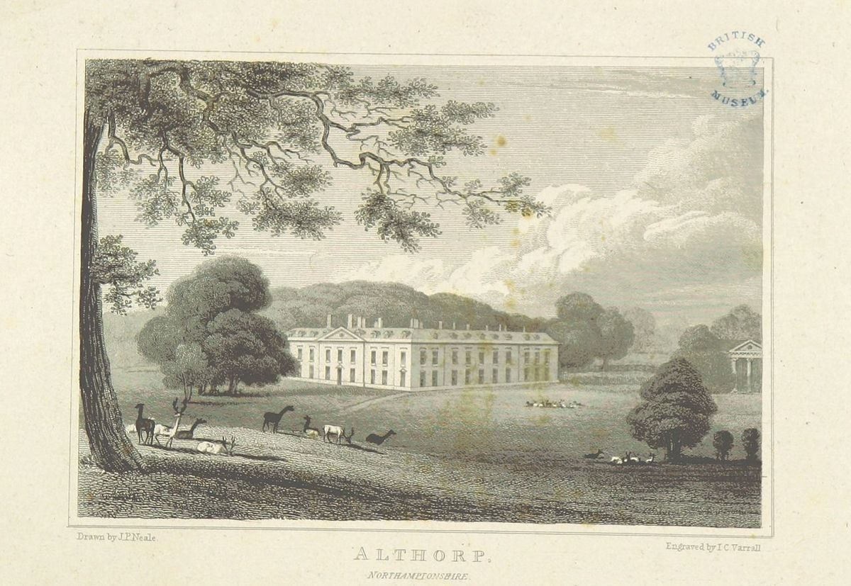
In 1780 Althorp was visited by Lancelot Brown (1716-83), who suggested judicious changes. By the time of Brown's sudden death in 1783 nothing had been done, and his erstwhile foreman Samuel Lapidge had hopes of carrying out the contract. In 1790 however Brown's architect son-in-law Henry Holland, who was working on the house, produced his own plan, apparently the basis for at least some changes which followed, including the filling of the moat and the bringing of the park up to the house.
KITCHEN GARDEN
New kitchen gardens were created c 1730 in the south-west corner of the park to a design by Roger Morris, comprising a main brick-walled compartment c 250m south-west to north-east and c 100m wide, with slips to north, west and south. These replaced earlier gardens in the same position shown in Tillemans' view of 1721 (Bailey 1996, 4). The walls of the main compartment (listed grade II), with diaper work and other decorative features and early C19 iron lattice gates, survive, as do the ironstone walls of the compartment to the south. Both compartments are now grassed; no glass survives. Morris was probably also responsible for the lias ashlar, Palladian, colonnaded Gardener's House (listed grade II) at the north-west corner of the main compartment (Colvin 1980, 561). Originally a reclining statue (now in the house) was sited under the portico, at the head of a Grass Walk with floral borders which led north-east from the house, alongside the garden's north wall, to a contemporary ashlar screen and iron gates (listed grade II) in the north-east wall.
Adjoining the south-east corner of the walled garden is Garden Stew, the uppermost of a chain of four fishponds extending to the north-east.
REFERENCES
L Knyff and J Kip, Britannia Illustrata (1714)
Country Life, 49 (11 June 1921), pp 714-21; (25 June 1921), pp 792-7; (2 July 1921), pp 14-20; 127 (19 May 1960), pp 1122-5; 170 (30 July 1981), pp 375-8
M E Finch, Five Northamptonshire Families (1956), p 61
Northamptonshire Past & Present 5, (1973), p 219
D Stroud, Capability Brown (1975), pp 214-15
J Anthony, The Gardens of Britain 6, (1979), pp 17-22
J Harris, The Artist and the Country House (1979), p 67
H Colvin, A Biographical Dictionary of British Architects 1600-1840 (1980), p 561
Roy Comm Hist Mons Engl Inventories: Northamptonshire 3, (1981), pp 1-3
D Jacques, Georgian Gardens (1983), pp 112-13, 140/1
S Markham, John Loveday of Caversham (1984), p 345
T Mowl and B Earnshaw, Trumpet at a Distant Gate (1985), pp 28-9
Garden History 19, (1991), pp 146-54
J Heward and R Taylor, The Country Houses of Northamptonshire, (RCHM(E) 1996), pp 52-7
D Hall, Althorp Park 1998: Ridge and Furrow (unpublished study for English Heritage)
Maps
Brington Tithe map based on 1778 estate map (T 176), (Northants Record Office)
OS 6" to 1 mile:
1st edition published 1886
2nd edition published 1901
Archival items
The Althorp estate records are in the Northamptonshire Record Office (eg Spencer 741(894) and the British Library (early Spencer papers 1A, 1329-1757)
Description written: August 1998
Register Inspector: PAS
Edited: January 2000
- Visitor Access, Directions & Contacts
Telephone
01604 770006Website
https://althorpestate.com/Access contact details
For detailed visitor opening visit the Althorp Estate website.
Directions
Seven miles west of Northampton, off the A482.
for more detailed directions visit the Althorp Estate website.
Owners
Earl Spencer
- History
The original park was laid out in the early 16th century when John Spencer acquired a licence to impark 400 acres (about 162 hectares) of land, 100 acres (about 40.4 hectares) of woodland and 40 acres (about 16 hectares) of waste. The park had a formal layout of avenues by the mid- to late 17th century, as well as canals, fishponds and game. At this time there were formal walled gardens around the house incorporating a medieval or post-medieval moat.
Lancelot Brown advised on improvement to the park in 1780 but died before the work could be carried out. From 1787-1791 the house was remodelled and the parkland and gardens redesigned by Henry Holland with help from Samuel Lapidge. The moats around the house were filled in at this time.
A further phase of development took place in the 1870s. The Round Oval lake was cleaned out and re-filled and the formal gardens remodelled by W M Teulon. A summerhouse in the style of a garden temple was bought in 1901 and moved to its current position beside the lake in 1926.
The landscape and garden designer Dan Pearson has been involved in the recent redevelopment of the grounds.
The following is from the Register of Parks and Gardens of Special Historic Interest. For the most up-to-date Register entry, please visit The National Heritage List for England (NHLE):
HISTORIC DEVELOPMENT
John Spencer (d 1522), a Warwickshire grazier, purchased Althorp in 1508, and in 1512 acquired licences to crenellate and make a park. His great-grandson Robert, who inherited in 1599, was created Baron Spencer in 1603 and was 'reputed to have the most money of any person in the kingdom' (Heward and Taylor 1996, 52). He entertained the Queen at Althorp in 1603, while his son William, second Baron (d 1636) and later members of the family were well known at court. One of those was William's grandson Robert, the second Earl, who inherited as an infant in 1643. He travelled widely in Europe, and in the years after 1666 the house was transformed and probably the park given a complex grid of avenues. The Spencers also married well, and in 1733 Robert's grandson Charles Spencer, ninth Earl of Sunderland (d 1758), inherited the dukedom of Marlborough. According to a family settlement he thereby devized Althorp to his younger brother John (d 1746). The family's interest in hunting at this time is evidenced by nine large paintings by John Wootton (d 1764), completed in 1733. These depict a hunt at Althorp and at nearby Holdenby (qv), and as well as the county gentry show characters including the earth stopper. Both John and his son John (d 1783), created Earl Spencer in 1765, spent little time at Althorp. The house was remodelled 1787(90 by the latter's son George, second Earl (d 1834), while John, fifth Earl (d 1910), who inherited in 1857, carried out further work on the house in the 1870s and also remodelled the gardens. Althorp remains (1998) in private hands.
Period
- Post Medieval (1540 to 1901)
- Victorian (1837-1901)
- Associated People
- Features & Designations
Designations
The National Heritage List for England: Register of Parks and Gardens
- Reference: GD2025
- Grade: II*
Historic Environment Record (Local Authority)
- Reference: SMR 1009 - MNN3846
Style
English Landscape Garden
Features
- Ornamental Lake
- Description: The Round Oval lake, with a central island.
- Summerhouse
- Description: A summerhouse in the form of an open-fronted temple constructed of timber with a lead roof. It is sited by the Round Oval lake and dedicated to the memory of Diana, Princess of Wales.
- Earliest Date:
- Latest Date:
- Sculpture
- Country House (featured building)
- Description: Althorp is a 16th-century house remodelled between 1786 and 1790 and refaced with white bricks. The original red-brick house had a courtyard but the building is now U-plan. Further work was carried out during the 1870s.
- Earliest Date:
- Latest Date:
- Screen
- Description: Three screens composed of wrought iron railings with ashlar piers surmounted by urns with a low wall between, dating back to around 1863.
- Stable Block
- Earliest Date:
- Latest Date:
- Ironwork
- Description: Wrought iron railings and double gate, probably dating back to the late 18th century.
- Loggia
- Description: This 'loggia' is a covered passage between the moat and the gardens, probably 16th-century.
- Ha-ha
- Description: A ha-ha with balustrade, probably by Teulon.
- Earliest Date:
- Latest Date:
- Icehouse
- Earliest Date:
- Latest Date:
- Gate Lodge
- Description: A pair of lodges and gatepiers with gates, around 1810.
- Artefact
- Description: A number of planting stones commemorating the planting of avenues, woodlands and memorial plantings from the early 17th to the early 20th century.
- Gate Lodge
- Description: A pair of lodges and gatepiers with gates, around 1730.
- Key Information
Type
Park
Purpose
Ornamental
Principal Building
Domestic / Residential
Period
Post Medieval (1540 to 1901)
Survival
Extant
Hectares
225
Open to the public
Yes
Civil Parish
Althorp
- References
References
- {English Heritage Register of Parks and Gardens of Special Historic Interest}, (Swindon: English Heritage, 2008) [on CD-ROM] Historic England Register of Parks and Gardens of Special Historic Interest
- Stroud, D., {Capability Brown} (London: Faber, 1975), pp. 214-5 Capability Brown
- Harris, J., {The Artist and the Country House} {London: Russell Chambers, 1979), p. 67 The Artist and the Country House
- Anthony, J., {The Gardens of Britain 6: The East Midlands} (London: Batsford, 1979), pp. 17-22 The Gardens of Britain 6: The East Midlands
- Pevsner, N. and B. Cherry, {The Buildings of England: Northamptonshire} (Harmondsworth: Penguin, 1973), pp. 81-3 The Buildings of England: Northamptonshire