Introduction
Alscot is a landscape park of about 100 hectares. It surrounds a large gothic house dating from 1752, with 19th and 20th-century garden development. There are also formal gardens of about 2 hectares, including a lavender garden, orangery, walled vegetable garden and herb beds.
Terrain
The river flows from south to north, and the ground to the north-west and west of the river rises steeply to a level plateau occupied by parkland. The ground to the east of the river is generally level, with a sharp fall south-west towards the river.The large Gothic house has been in the possession of the family since 1747. It is set in open parkland that is very much in the style of Lancelot 'Capability' Brown. There is a ha-ha, deer park, river and large cedar trees. There is also a formal garden of some 2.5 hectares. This includes yew hedging, a lime walk, mixed borders, an orangery, lavender garden, herb beds and a walled vegetable garden.
The following is from the Register of Parks and Gardens of Special Historic Interest. For the most up-to-date Register entry, please visit the The National Heritage List for England (NHLE):
www.historicengland.org.uk/listing/the-list/
A mid-18th-century rococo landscape attributed to Sanderson Miller, together with mid-19th-century formal terraced gardens designed by William Davidson.
DESCRIPTION
LOCATION, AREA, BOUNDARIES, LANDFORM, SETTING
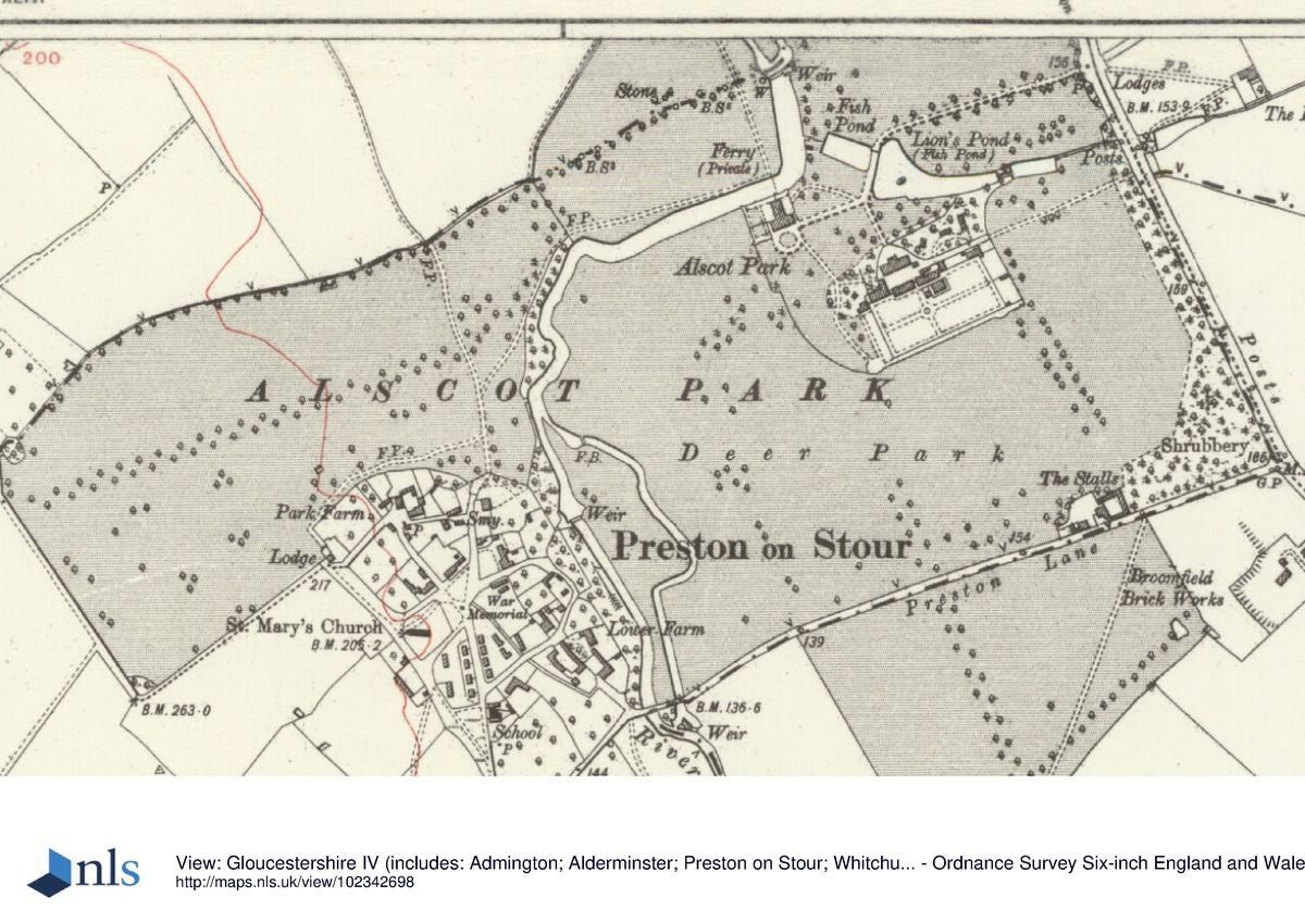
Alscot Park is situated c 4.5km south of Stratford-upon-Avon, and c 0.75km north-east of the village of Preston on Stour, to the south-west of the A3400 road. The c 100ha site comprises some 8ha of formal terraces, pleasure grounds, walled gardens and ponds around the house, and c 92ha of parkland. To the east the site is bounded by the A3400 road, and to the south-east and south-west by a minor road, Preston Lane. To the south, west and north-west the site adjoins agricultural land, from which it is separated by fences and hedges, while to the south-west it adjoins domestic properties in the village of Preston on Stour. To the north the boundary is formed by domestic properties in the village of Atherstone on Stour, which lies c 0.75km north-west of Alscot Park. The River Stour flows from south to north through the site immediately to the north-west of the house, and the ground to the north-west and west of the river rises steeply to a level plateau occupied by parkland. The ground to the east of the river is generally level, with a sharp fall south-west towards the river lying immediately outside the site boundary. There are extensive views east across the river, house, gardens and park to agricultural land beyond from the high ground in the western park.
ENTRANCES AND APPROACHES
Alscot Park is approached from the A3400 road to the east. A pair of single-storey, early C19 gothic lodges (listed grade II) flank the entrance which is closed by C19 wrought-iron gates. The lodges are constructed in stone and cement render and have castellated parapets and ogee-headed windows. The design of the lodges and gates is attributed to George Clark of Wootton Wawen (Tyack 1994); a scheme designed by John Webb was not implemented (Colvin 1978). The tarmac drive, flanked by an avenue of limes, extends c 240m west-south-west through the park, before sweeping south-south-west to cross the dam retaining Lion's Pond c 130m north-east of the house and which separates it from a lower pond. The dam has a mid C19 stone balustraded parapet to east and west giving the impression of a bridge, while to the west there is a high stone retaining wall. The design of the artificial bridge is attributed to George Clark (Tyack 1994). Immediately south of the bridge a service drive leads c 50m south-east to the mid C18 brick stables (listed grade II), which were built by James West c 130m south-east of the house in 1753. The principal drive continues c 80m south-west to reach the gravelled carriage turn below the south facade of the house; the drive encircles a central circular panel of lawn. A service drive leads from the stables c 300m north-east to join the A3400 road c 160m south-east of the main entrance.
PRINCIPAL BUILDING
Alscot Park (listed grade I) stands on a terraced site on the south bank of the River Stour, towards the centre of the park. The house is roughly T-shaped on plan, with a lower north wing comprising three storeys running north to the river from the principal or south wing. The north wing has crenellated parapets and mullioned windows. A canted full-height bay window on the north facade and a pair of similar bay windows at the south end of the west facade have ogee-headed windows. The south wing, built at right-angles to the north wing, is a taller structure comprising two storeys. It has a similar crenellated parapet and hipped roofs, while it is lit throughout by ogee-headed gothic windows. The east and west facades each have a full-height canted bay window, while the south or entrance facade has a pair of ogee-capped octagonal turrets which flank an early C19 single-storey porch. The porch, designed by Thomas Hopper in 1815-20, has a large ogee-arched doorway and a pair of octagonal pinnacles echoing the form of the turrets.
The north wing incorporates elements from an earlier house which was rebuilt by James West in 1749-52 and provided with rococo interiors. West commissioned the London carpenters John Phillips and George Shakespear, and the Chipping Campden mason Edward Woodward to execute his improvements. The south wing was built for West in 1762-4 by the same craftsmen, and also includes significant rococo interiors with plasterwork by Robert Moore of Warwick and papier-mâché ornaments by Thomas Bromwich (Tyack 1994). Minor changes were made to the house in the mid C19 for James Roberts West by a local builder, George Clark of Wootton Wawen.
GARDENS AND PLEASURE GROUNDS
Formal terraced gardens lie to the west and north-west of the house, with areas of informal pleasure grounds to the south and east of the house. The terraced gardens comprise a smaller, upper terrace below the west facade of the south wing of the house, and two parallel lower terraces to the west of the north wing. The terraces are bounded to the south, west and north by mid C19 low stone balustrades with ogee-shaped moulded openings. Circular bastions project at the south-west, north-west and north-east corners of the terraces. A stone-flagged terrace extending the full width of the west facade of the south wing descends in a broad flight of stone steps to the upper terrace, which is square on plan and today (2000) laid to grass with deep rose borders to the north and south. A C20 yew hedge encloses the upper terrace to the north, and there are extensive views west across the river and park. Flights of stone steps descend from the north-west and north-east corners of the upper terrace to the north terraces which comprise two rectangular terraces separated by a bank and each laid out with a pair of square panels, today planted with simple patterns in lavender and Santolina. The panels are divided by gravel walks, and linked by flights of stone steps aligned on those descending from the upper terrace. A further flight of steps aligned with the eastern walk descends to the river, while a gravel walk extends from west to east to the north of the terraced gardens, parallel to the river. To the east, this walk is terminated by a bastion, while a landing stage north-east of the house gave access to a private ferry to the north bank of the river. The mid C19 terraced gardens were designed by William Davidson of Great Russell Street, London (plan, private collection); Davidson also designed Rugby Cemetery, Warwickshire (1863).
The pleasure grounds south and east of the house comprise lawns planted with specimen trees and evergreen shrubs, and are separated from the park to the west by low mid C19 stone balustrades and C19 metal fences. Mid and late C20 specimen trees have been added to mature cedars, sweet chestnuts and yews to frame the south facade of the house. To the north, the pleasure grounds adjoin Lion's Pond and a smaller rectangular pool to the west. Some 100m south-east of the house an area of evergreen shrubbery and mature trees screens the stables and kitchen garden. Informal curvilinear walks lead through the shrubbery, passing a C19 summerhouse or shelter c 120m south-east of the house. This single-storey gabled brick structure has ornamental bargeboards and an area for standing out potted plants to the south-east. Some 10m south-east of the summerhouse an outcrop of Pulhamite rocks is arranged against the north wall of the Orangery. These artificial rocks survive from the internal arrangement of a fernery which was constructed in 1870 (Meir 1999); the remainder of the fernery is now (2000) demolished. The Orangery, a mid C18 brick structure lit by five tall sash windows and a late C20 glass roof stands c 140m south-east of the house overlooking a mid C20 rectangular garden enclosed to the west and south by yew hedges, and to the east by the west wall of the kitchen garden. The garden is laid out with herbaceous borders parallel to the east and west boundaries, with a rectangular, stone-edged swimming pool set in a central lawn. To the south of the swimming pool lies a C19 stone circular fountain basin, beyond which an opening in the yew hedge to the south, flanked by topiary ball finials, leads to a further rectangular enclosure with mixed borders adjoining a central lawn. To the south, a further opening in a yew hedge, flanked by topiary pyramids, reveals views through C19 railings to the park.
There is a further area of informal C19 shrubbery with specimen trees c 160m south-east of the house which screens the kitchen garden. This area of shrubbery extends north-east to the head of Lion's Pond.
PARK
Surrounding the house on all sides, the park today (2000) remains predominantly pasture, with areas in arable cultivation to the south and west. The River Stour flows in an S-shaped course from south to north through the park, and is raised and widened by a stone weir c 160m north of the house; there are further weirs controlling the level of the river flowing through the park to the east of the village of Preston on Stour. The river was modified by James West in 1747(8, possibly with the advice of Sanderson Miller (Meir 1999). A minor road, Preston Lane, crosses the park from west to east c 530m south of the house, connecting the village of Preston on Stour with the A3400 road to the east. Preston Lane is carried across the River Stour on a mid C19 bridge constructed by George Clark at the south-west corner of the park. The boundary of the park with the A3400 road is screened by plantations, extensively replanted in the late C20; these plantations return along the south and south-east boundaries of the park. The late C19 OS map indicates a walk passing through the plantations parallel to the east and south-east boundaries to reach farm buildings which survive c 550m south-east of the house. A mid C18 Chinese seat (no longer extant) was situated in the plantation to the south of the park (ibid).
The park to the north-east of the house is bounded to the west by the artificially widened River Stour, and is separated from the pleasure grounds to the south by a chain of three ponds. The central, larger pond, Lion's Pond, is approximately triangular on plan with a small island towards its wider, west end. The ponds to east and west of Lion's Pond are approximately rectangular on plan. The ponds are of C17 origin or earlier, and are described by Mrs West in a letter of c 1744 as 'three very fine pieces of water in the park'; they were used for keeping fish. The ponds were modified by James West in 1747-8, when one pond, perhaps Lion's Pond, was enlarged (ibid). To the east of Lion's Pond the remnants of an avenue extend c 240m east across the park to the road; to the west this avenue is aligned on the drive leading to the south front of the house. The remnant of a similar avenue extends through the park to the south of the house from a point c 350m south-south-east of the house, crossing Preston Lane, and thence for c 320m south-south-east through land today (2000) in arable cultivation, to reach woodland on a south-facing slope which drops sharply to the level of the river c 930m south-east of the house. A single line of trees follows an approximately parallel course c 150m west of the south avenue, and extends c 430m south-east across Preston Lane from an ornamental clump of trees in the park c 300m south-west of the house. There are further C19 clumps of ornamental trees in the park c 160m south-west of the house. The park to the east and south of the house corresponds to the early deer park, and is marked as an enclosure with a pale fence on Beighton's Map of Kington Hundred (1730). The avenues to the south and east of the house survive from James West's mid C18 layout; the south avenue is recorded on Yates' Map of Warwickshire (1793).
A further area of park, today (2000) remaining as pasture, lies to the west and north of the River Stour. The area to the north of the house and river is relatively level, while the ground to the west rises sharply from the level of the river. A C19 plantation including ornamental specimen conifers stands on the east-facing slope above the river c 270m west of the house, while c 430m west-south-west of the house a rounded mound overlooks the house, river and south park from the crest of the slope above the river. Some 80m south-east of the mound, and linked to it by a levelled terrace, a declivity containing a spring descends from the crest of the slope to the river. These features survive from a rococo pleasure ground created by James West c 1749, which is recorded on a plan of that year (private collection) by an unidentified surveyor. The mound was the site of a rotunda, while a Chinese pavilion stood in an area of shrubbery; both of these features are shown in elevation on the plan, but do not survive today. The terrace, with its far-reaching easterly views, was inspired by that designed by Sanderson Miller at Farnborough Hall, Warwickshire (qv) (Meir 1999). The pleasure ground, similar to the contemporary example at Honington Hall, Warwickshire (qv) which was developed with the advice of Sanderson Miller, was approached by crossing the river on the ferry to the north of the house, and thence by a walk which led through the park north and west of the river. A further walk led through shrubbery on the southern boundary of the west park, skirting Park Farm, to reach a lodge c 700m south-west of the house. The lodge, which survives today (2000), gives access to a wide track (beyond the registered site) which leads to the parish church in Preston on Stour. The network of walks surviving from the mid C18 pleasure ground is recorded on the 1884 OS map, together with an avenue extending c 600m west-south-west from a point immediately south of the mound; this avenue does not survive today. The avenue was formerly terminated to the south-west by a mid C18 obelisk, which had been removed by 1884 (OS). Further mid C18 landscape structures including a root house, Chinese seat and a summerhouse do not survive; mid C18 plans for a rusticated icehouse and a cascade between the pools east of the house survive (private collection) but the structures themselves do not survive today.
KITCHEN GARDEN
The kitchen garden, extending to some 1.5ha, lies c 160m south-east of the house and is screened from view by C18 and C19 shrubbery and specimen trees. The garden is rectangular on plan and is enclosed by mid C18 brick walls c 3m high. Today (2000) the garden remains in cultivation as a productive and ornamental garden, with a late C20 layout following the pattern recorded on the late C19 OS maps with eight roughly rectangular beds arranged in two parallel groups each comprising four beds. Apple trees are trained over mid or late C20 metal arches over the principal paths which divide the beds, and a central circular dipping pool survives from the C19 garden.
REFERENCES
J P Neale, Views of the Seats ... II, (1819)
E P Shirley, Some Account of English Deer Parks (1867), pp 194, 196
J Harvey Bloom, History of Preston on Stour (1896) Country Life, 123 (15 May 1958), pp 1064-7; (22 May 1958), pp 1124-7; (29 May 1958), pp 1184-7
Victoria History of the County of Gloucestershire 8, (1968), pp 83-5
N Pevsner and A Wedgewood, The Buildings of England: Warwickshire (1966), pp 63-5
H Colvin, A Biographical Dictionary of British Architects 1600-1840 (1978), p 874
R Sidwell, West Midland Gardens (1981), pp 187-8
G Tyack, Warwickshire Country Houses (1994), pp 1-5
J Meir, Alscot Park, Warwickshire, (Warwickshire Gardens Trust 1999)
Maps
H Beighton, A Map of Kington Hundred, surveyed 1725, published 1730
W Yates and Sons, Map of Warwickshire, surveyed 1787-9, published 1793
OS Old Series 1" to 1 mile, published 1831
OS 6" to 1 mile:
1st edition surveyed 1883, published 1884
2nd edition published 1903 1924 edition
OS 25" to 1 mile:
1st edition published 1886
2nd edition published 1902
1923 edition
Archival items
The West family papers, including James West's mid C18 Memorandum Book with details of landscape works, architectural drawings and estate plans, are held in a private collection.
Description written: April 2000 Amended: July 2000, September 2000
Register Inspector: JML
Edited: December 2000
- Visitor Access, Directions & Contacts
Telephone
020 7259 5688Website
https://www.alscot.co.ukAccess contact details
Open to groups by special arrangement ONLY.
- History
The following is from the Register of Parks and Gardens of Special Historic Interest. For the most up-to-date Register entry, please visit the The National Heritage List for England (NHLE):
www.historicengland.org.uk/listing/the-list/
HISTORIC DEVELOPMENT
A manor house has existed at Alscot since the 12th century, while the associated park was developed in the 15th century (Country Life 1958; Tyack 1994). The lords of the manor were generally absentee owners until the late 16th century, but in the early 17th century the existing dwelling was remodelled (Tyack 1994). Further changes were made in the early 18th century by Richard Marriett (died 1744), whose brother-in-law, John Lowe, in 1747 sold Alscot together with neighbouring property, to James West. West (1703-72), the grandson of a wealthy London cloth merchant, had travelled extensively and following his marriage to the heiress of a London timber merchant, in 1741 entered Parliament as Member for St Albans. In 1743 West was appointed secretary to Henry Pelham, the Lord Chancellor, and in 1746 the patronage of the Duke of Newcastle secured his appointment as Joint Secretary to the Exchequer. West's principal residence was in the Piazza at Covent Garden, and Alscot, described by his wife as 'the comicalist little old house that you ever saw' was acquired as a country retreat (correspondence, quoted by Tyack 1994). The house was rebuilt in a distinctive Rococo Gothic style in two stages, the first, in 1750-2, coinciding with improvements to the grounds, probably with the advice of Sanderson Miller (1716-80) (J Meir personal communication, 2000). Alscot is one of a group of sites in Warwickshire at which Miller advised which include Arbury Hall, Farnborough Hall, Honington Hall, and Packington Hall; he also developed his own grounds at Radway Grange, Warwickshire (see description of all these sites elsewhere in the Register). Miller visited Alscot with George Lyttleton of Hagley Hall, Worcestershire (see description of this site elsewhere in the Register) in April 1750, and drew 'a plan' for West (Meir 1999); the subject of this plan is unknown. Richard Jago noted 'Alscot's swelling lawns, and fretted spires, Of fairest model, Gothic or Chinese' in his poem Edge Hill (1767).
James West retired from politics in 1762, and a new wing, completed in 1764, was built to house paintings and artefacts removed from Covent Garden. In 1767 West noted a visit to Alscot by 'Mr Brown', but there is no indication whether this refers to Lancelot Brown. West died in 1772, and his widow continued to occupy Alscot until her death in 1790; the estate subsequently passed to West's grandson, James Roberts West. John Webb (around 1754-1828) provided designs for a gothic lodge in 1810 but these plans were not executed. James Roberts West died in 1838 and Alscot was inherited by his son of the same name, who made alterations to the house and gardens in the mid-19th century. In 1882 James Roberts West II was succeeded by his son, who married the heiress of William Alston of Elmdon Hall, Warwickshire. Today (2000) Alscot Park remains in the private ownership of the West family.
- Associated People
- Features & Designations
Designations
The National Heritage List for England: Register of Parks and Gardens
- Reference: GD2188
- Grade: II
Features
- Ha-ha
- Walk
- Description: Lime walk
- Planting
- Description: Lavender garden
- Hedge
- Description: Yew hedging
- Bed
- Description: Herb bed
- Orangery
- River
- Tree Clump
- Description: Large cedar trees.
- Potager
- Description: Walled vegetable garden.
- House (featured building)
- Description: The house was rebuilt in a distinctive Rococo Gothic style between 1750 and 1752.
- Earliest Date:
- Latest Date:
- Key Information
Type
Estate
Purpose
Ornamental
Principal Building
Domestic / Residential
Survival
Extant
Hectares
100
Open to the public
Yes
Civil Parish
Shipston on Stour
- References
References
- {English Heritage Register of Parks and Gardens of Special Historic Interest}, (Swindon: English Heritage, 2008) [on CD-ROM] Historic England Register of Parks and Gardens of Special Historic Interest
- Elrington (ed), {Victoria History of the Country of Gloucester} ([n.p]: [n.pub], Volume 8 1968), pp. 83-5 Victoria County History: Gloucester, Volume 2
- Sidwell, R., {West Midland Gardens: the gardens of Hereford & Worcester, Shropshire, Staffordshire, Warwickshire and West Midlands} (Gloucester: Sutton, 1981), pp. 187-8 West Midland Gardens: the gardens of Hereford & Worcester, Shropshire, Staffordshire, Warwickshire and West Midlands
- Pevsner, N. and A. Wedgwood, {The Buildings of England: Warwickshire} (Harmondsworth: Penguin Books, 1966), pp. 63-5 The Buildings of England: Warwickshire
- Tyack, G., {Warwickshire Country Houses} (Chichester: Phillimore, 1994), pp. 1-5 Warwickshire Country Houses