Introduction
Abington Park is probably Northamptonshire's oldest, and best surviving municipal park. It continues to be a major recreational focus for the county town and hosts civic events such as the annual Northampton Show. Its importance to the community is amplified by its prior existence, from at least the late-17th century, as the parkland of a private estate. The surviving elements of its earlier use considerably enhance the later municipal landscape.
The civil parish of Abington had remained largely empty of settlement and in 1900 was subsumed within the parish of Northampton. Accordingly, expansion of Northampton in the early twentieth century almost completely surrounded the parkland. In 1903 the Lower Park was also acquired by Northampton Corporation, creating in total about 116 acres of public parkland. In 1904 a bowling lawn was opened and by 1913 an octagonal bandstand had been erected. The bandstand survives, but it appears to have been enclosed by a wall with iron railings originally.
The foundations of this enclosure are still visible as parchmarks in the grass during dry summers, along with the possible remains of a path leading to the bandstand. A local newspaper records that in 1909 many of the old trees of the parkland were considered to be dangerous and were cut down. Large-scale replanting followed with over 500 trees within six months; the report lists the new planting. Ornamental aviaries were also constructed from 1912 to house an expanding collection of exotic birds, these still stand on the west side of the abbey. After the First World War six field guns and a military tank were installed in the Upper Park. These were removed in 1935.
Thus, by 1925 and the publication of the O.S. Third Edition 25 Inch Map many changes had taken place in the landscape. Additionally, the large rectangular pond in the centre of Lower Park had been enlarged and given a more natural form, with islands. The smaller, uppermost, rectangular pond now used for boating had a path constructed around it. Hence, the modern municipal boating lakes and ornamental ponds are undoubtedly remodelled from their post medieval and later forerunners, which themselves were probably adapted from medieval fishponds. Avenues of trees were planted, radiating away from the large pond in most directions across the Lower Park. A third pond was constructed in the valley, by its south-eastern boundary. Suburban encroachment of the parkland had taken place on the west side of the Upper Park, and more significantly at the north-eastern corner of Lower Park.
The subject of much speculation has been an earthen mound at the northern edge of the park, to the north-west of the Abbey. The most obvious suggestion has been that the mound represents spoil from a period of landscaping of the park. Recent speculation has however dwelt upon the possible indication of a grotto-like feature on the 1750 engraving, the remains of which may be buried beneath the mound. The first record of the mound appears to be the O.S. First Edition 25 Inch map of 1887.
During the 1960s the recreational scope of the parkland was expanded with the construction of additional bowling greens, tennis courts and cricket tables. In 1979 the Garden for the Blind was opened combining features of sound, touch and scent including planting and a fountain from which water plays on metal cymbals. A butterfly garden has also recently been constructed. Detailed planting lists for the modern park have been drawn up.
A large collection of early photographs and postcards of Abington Park in the Northamptonshire Local Studies Library catalogues many of the changes made to the landscape during its period as a public park, including extensive carpet bedding which has now all but disappeared due to modern management needs.
Abington is an important historical and archaeological landscape which holds high potential for promoting public awareness and understanding of its evolution. The main focus of the landscape is still the surviving church and country house. Preserved within the parkland, albeit in poor condition, are the nationally important earthworks of the deserted village and its associated field system; these have been proposed for Scheduling as Ancient Monuments via the Monuments Protection Programme. The close relationship of the private parkland to the deserted village, its later use as a Victorian public park within which survive key elements of the parkland's earlier development, and subsequent twentieth century enhancement of its municipal role render Abington one of the most important stretches of public open space in Northamptonshire.
Northamptonshire SMR Monument Numbers:
1694 Abington village, church and manor
1697 Abington landscape park
6298 Abington municipal park
A list of bibliographic references is held on the SMR.
Thanks are due to Alan Adkinson of Northampton Borough Council for access to his draft report on Northampton's public parks, and to Jenny Burt of the Northamptonshire Gardens Trust for access to her documentary data.
Detailed description contributed by Northamptonshire Gardens Trust 25/05/2016
- Visitor Access, Directions & Contacts
Website
https://abingtonpark.orgAccess contact details
This is a municipal park, open daily to the general public.
Owners
Northampton Borough Council
Guildhall, St. Giles Square, Northampton, NN1 1DE
- History
Abington Park is located about two miles east of Northampton town centre, along the old main road to Wellingborough. It is probably Northamptonshire's oldest, and best surviving municipal park. Although surrounded by suburban development of the early twentieth century onwards, when officially opened to the public in 1897 the park lay on the edge of the surrounding countryside. It continues to be a major recreational focus for the county town and hosts civic events such as the annual Northampton Show. Its importance to the community is amplified by its prior existence, from at least the late seventeenth century, as the parkland of a private estate. The surviving elements of its earlier use considerably enhance the later municipal landscape. Abington takes its name from the medieval settlement which was swept away during one of several phases of parkland development.
A settlement at Abington was first recorded in 1086. The earliest known map of the village is dated to 1671, shortly after the manor changed ownership. It shows settlement set around staggered crossroads. The parish appears to have been largely enclosed by private agreement in 1659, and the park was certainly in existence by 1665. It is possible that its creation involved an early removal of houses from the village.
The manor at Abington was held by the Bernard family from 1415 and it was the Bernards who in the early sixteenth century built the first major phase of the present manor house. The 1671 map places the manor in the village's north-west quadrant and separated from "The Lawnd" to the north-east by houses. The entrance to the manor is indicated by an ornamented gateway on the boundary to the south of the manor house. To the west of the house lies an enclosed area called Saffron Yard. It was probably the Bernards who also laid out the small enclosed area called "The Parke" containing a group of fishponds, which lay to the east of the house in 1671.
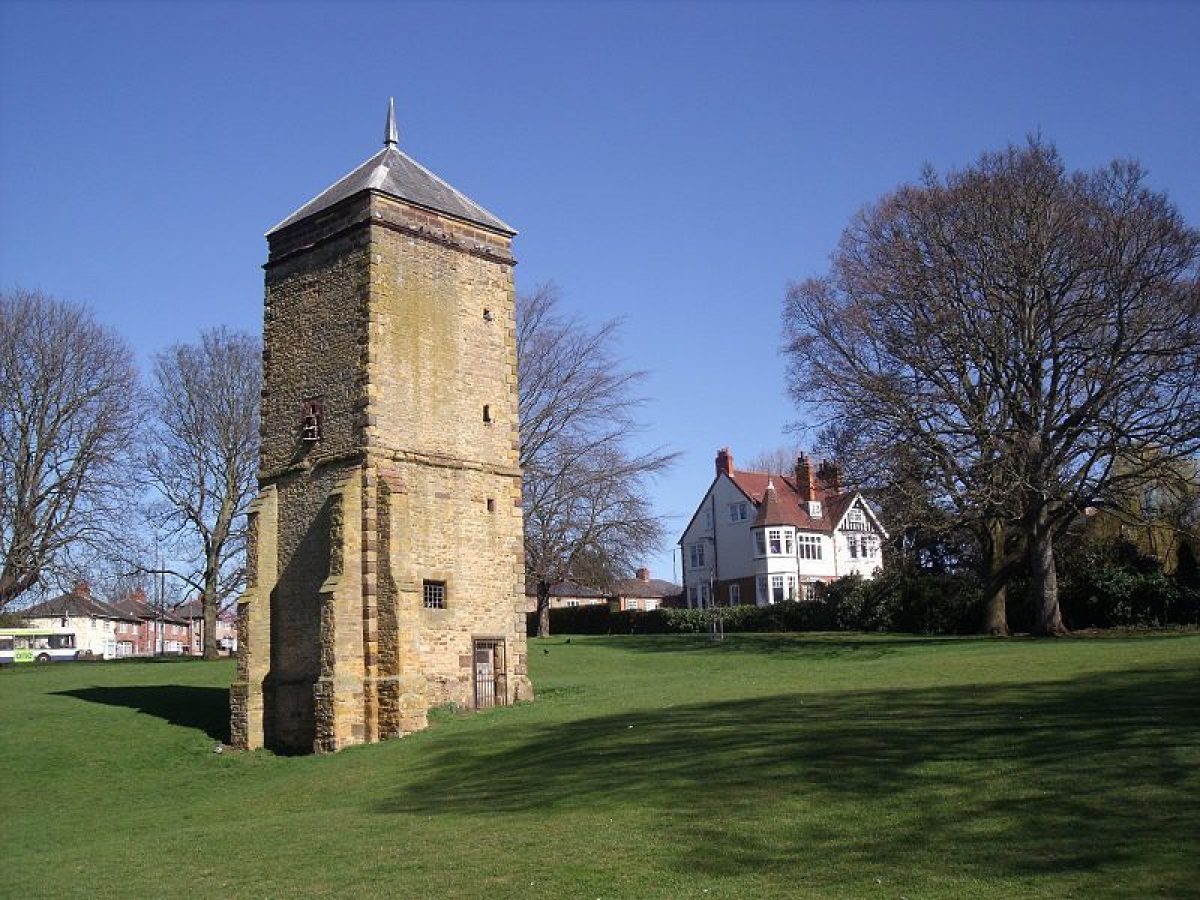
In 1669 Sir John Bernard sold the manor to a lawyer of the Middle Temple, William Thursby and between 1675 and 1678 the house was largely rebuilt. By the 1720s further emparkment had evidently begun with expansion eastwards across the valley. A principal feature of this extension was the stone tower built in 1678 by William Thursby on the site of a well-head shown on the 1671 map. The slate-roofed tower accomodated a well, served by a waterwheel, with a dovecote in the roof above. In the early eighteenth century the Northamptonshire historian John Bridges records the presence of a waterhouse and reservoir; the tower still forms a focal feature of the park just to the north of the boating lake, the latter of which may in an earlier form have been the aforementioned reservoir.
Also in the late seventeenth century, the entrance into Abington was formalised by the erection of a stone gateway. It took the form of two symmetrical stone-built cottages linked by a roundheaded arch, through which one of the main roads into the village ran. Archway Cottages, though no longer the entrance, still stand on the northern edge of the present municipal park, on the south-east corner of the junction of Wellingborough Road with Park Avenue South.
In the seventeeth century the medieval Rectory at Abington was rebuilt. The new building later became the Park Keeper's cottage and part of Park Farm; it still stands, at the edge of the park next to Christchurch Road.
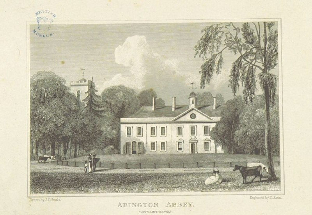
The process of removal of the village was completed between 1736 and 1742; with the exception of the church and manorial structures, all the buildings shown on the map of 1671 were removed and replaced by parkland. Following the death of William Thursby's nephew Richard, the estate passed to Richard's niece Mary, and in 1736 her husband John Harvey took the name of Thursby and commenced major alterations to the house, park and village. He remodelled and enlarged the house, building new south and east facades in front of the old in plain classical style circa 1740. The architect was probably Francis Smith of Warwick. Alterations inevitably involved improvement of the setting of the house including the laying-out of formal gardens to the south and west of the house, as illustrated in a contemporary view by B.Cole. In 1742 a mapped survey of the estate was also made, showing the new layout of the gardens around the house as well as further developments within the parkland.
In 1737 Thursby had obtained a faculty to take in part of the churchyard and rebuild a wall in perpendicular line from his mansion. This appears to have formed part of the laying out of a new formal entrance court to the south of the house which was bounded by side walls to the east and west and a ha ha along the main road to the south, crossed by a bridge to elaborate iron gates. The ha ha is known to have extended around on the east side of the house, also enclosing the church. Low earthwork scarps still represent the remains of the ha ha in the present parkland, and during dry weather, walling and the position of three posthole-like features with masonry are visible, which probably represent the foundations of the bridge and gateway.
The parkland was greatly enlarged to the north, east and west, and its landscaping caused the removal of the remainder of the village, the north-south running road which lay to the east of the house subsequently appears to have formed the main tree-lined approach to the house through the parkland. The group of small fishponds in the area previously called 'The Parke' were replaced by a group of subrectangular ornamental ponds. The pond in the valley to the east of the house was enlarged and a circular feature constructed between it and the earlier water tower to the north. An avenue of trees was planted running northwards from the house as far as the Northampton to Wellingborough road. A further avenue is indicated running from the large pond in the valley to the eastern park boundary. The perimeter of the park appears to have been lined with trees. Two small plantations are also indicated. None of this planting appears to have survived modern urbanisation.
In 1778 the famous Shakespearean actor David Garrick planted a mulberry tree close to the house at Abington.
Later eighteenth century development is indicated on a map of 1798. A string of ornamental ponds had been laid out in the bottom of the valley to the east of the house before the end of the eighteenth century. The second group of smaller ponds which led up towards the house from the valley had been reduced to one rectangular pond by this time. A modern 'sunken' garden which now occupies the site of these former ponds may have utilised the earthwork remains of this pond. Further expansion of the parkland southwards from the house had also taken place sometime in the late eighteenth century as the 1798 map shows a broad avenue lined with a double-row of trees stretching as far as the Billing Road. This late extension has been almost entirely built over since the early twentieth century. Little of the earlier north-running avenue is shown in 1798, and although the earlier boundary formed by the ha ha is still shown the formal garden layout has evidently disappeared. Accounts for gardeners as well as masons and bricklayers are recorded between 1798 and 1802 and remodelling of the house at this time is worthy of note because of the introduction of the Gothic element.
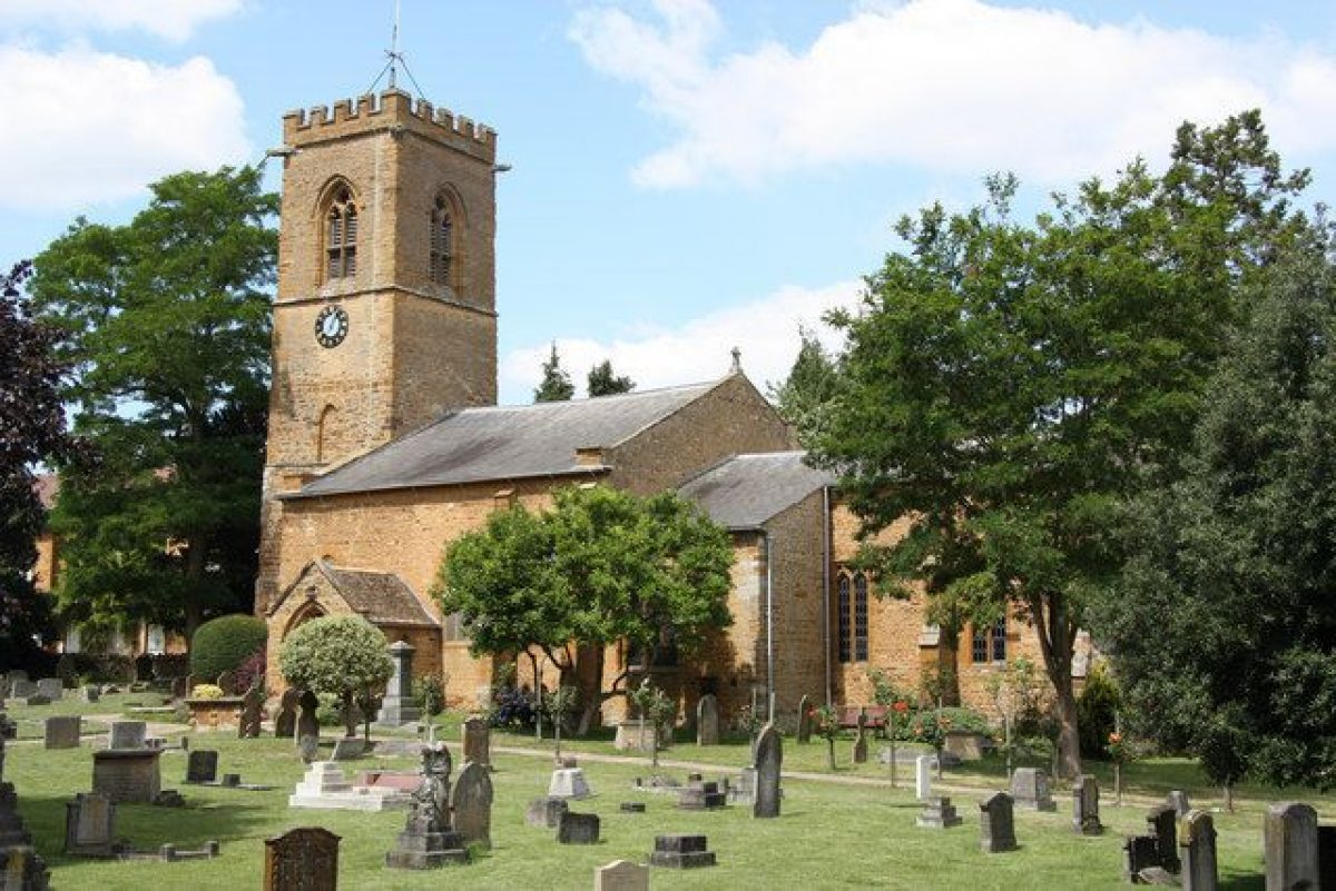
Abington church was largely rebuilt by the third John Harvey Thursby in the early 1820s following storm damage, and at about the same time a 'folly' in the form of an stone archway on two gatepiers with slit openings, buttresses and battlements was built on the east side of the valley. Recent field-survey work carried out by David Hall has identified the earthworks of terracing associated with this folly, adapted from the ridge and furrow of the earlier village's field system. Along with the conduit tower the ruins of this folly, known as The Hunting Gate, today form the main architectural focus on the east side of the public park.
The Gothic influence of the early nineteenth century is further corroborated by references to the house as 'Abington Abbey' from this time, which appears to have been a romantic whim on the part of the Thursby family, as no evidence of there ever having been a monastic establishment at Abington has been found.
Bryant's map of 1827 and the Ordnance Survey (O.S.) One Inch Survey of 1835 both indicate that prior to this time the string of ponds in the valley were altered to form only one large and one small pond. Bryant's map also suggests the presence of a walled garden, probably the kitchen garden, to the north-west of the house. The main approach to the house from the north had also been altered by this time, lying well to the west of Archway Cottages. A draft lease of 1836 also documents the presence at this time of gardens, hothouses, another dovecote, shrubberies and pleasure grounds, stables, dog kennels, and other outbuildings.
Following the death of the last Thursby in 1841 the estate was purchased by banker Lewis Loyd of nearby Overstone and leased for use as a private asylum. During this period George Clarke made several drawings of the house and its setting. A mapped survey of the estate was also made for Loyd in 1850. The property's use as a mental hospital continued until 1892.
In 1892 a north-south running road through Abington was re-instated slightly to the west of the original road. This road, now known as Park Avenue South, effectively divided the parkland into two areas of differing character which became known as the Upper and Lower parks.
Shortly after its use as an asylum the estate devolved upon Loyd's grand-daughter Lady Wantage, who later in 1892 made a gift of about 20 acres of the 'Abbey' and Upper Park to Northampton Corporation for, in her words, "a People's Park, the presentation of fine trees, and the maintenance of the old and picturesque fabric of the Abbey". In 1893 the Corporation purchased an additional 42 acres of parkland.
In 1896 a rough scheme was published in a local newspaper for the setting out of the public park; this scheme was not fully executed. Improvements were made to the house and grounds however, in time for their opening to the public in 1897 in celebration of Queen Victoria's Diamond Jubilee. An oak tree was planted on the lawn to the south of the Abbey to commemorate the event. In 1898 refreshment rooms were opened in the park, and a year later the public museum, housed in the Abbey, was ready to open. Further park improvements in 1900 make reference to the clearance of a dovecote, presumably the one mentioned in the 1836 lease (this may be the small circular feature shown on the 1887 First Edition O.S. map). Public opinion as to the "improvements" carried out were not always favourable, as recorded in local newspapers in 1900.
Detailed history contributed by Northamptonshire Gardens Trust 25/05/2016
- Features & Designations
Features
- Museum (featured building)
- Description: The public museum, opened in 1899, is housed in the Abbey.
- Bandstand
- Ruin
- Description: The remains of the medieval village.
- Ruin
- Description: The Church of St. Peter and St. Paul.
- Boating Lake
- Ornamental Lake
- Bowling Green
- Planting
- Description: Garden for the blind.
- Earliest Date:
- Latest Date:
- Key Information
Type
Park
Purpose
Recreational/sport
Principal Building
Parks, Gardens And Urban Spaces
Survival
Extant
Hectares
46.94
Open to the public
Yes
Electoral Ward
Abington