Introduction
Late 18th- and early 19th-century park and pleasure grounds, for which Humphry Repton produced a Red Book in 1792-3. Ston Easton has gardens and landscaped pleasure grounds of around 5 hectares and the remains of a park of some 87 hectares.
The site is now a hotel and wedding venue, and is open to guests.
Terrain
The site is divided into two approximately equal areas by a stream which flows from west to east. The area to the north of the stream is elevated and slopes gently from north to south. The area to the south is generally level.
Humphry ReptonThe following is from the Register of Parks and Gardens of Special Historic Interest. For the most up-to-date Register entry, please visit The National Heritage List for England (NHLE):
Location, Area, Boundaries, Landform and Setting
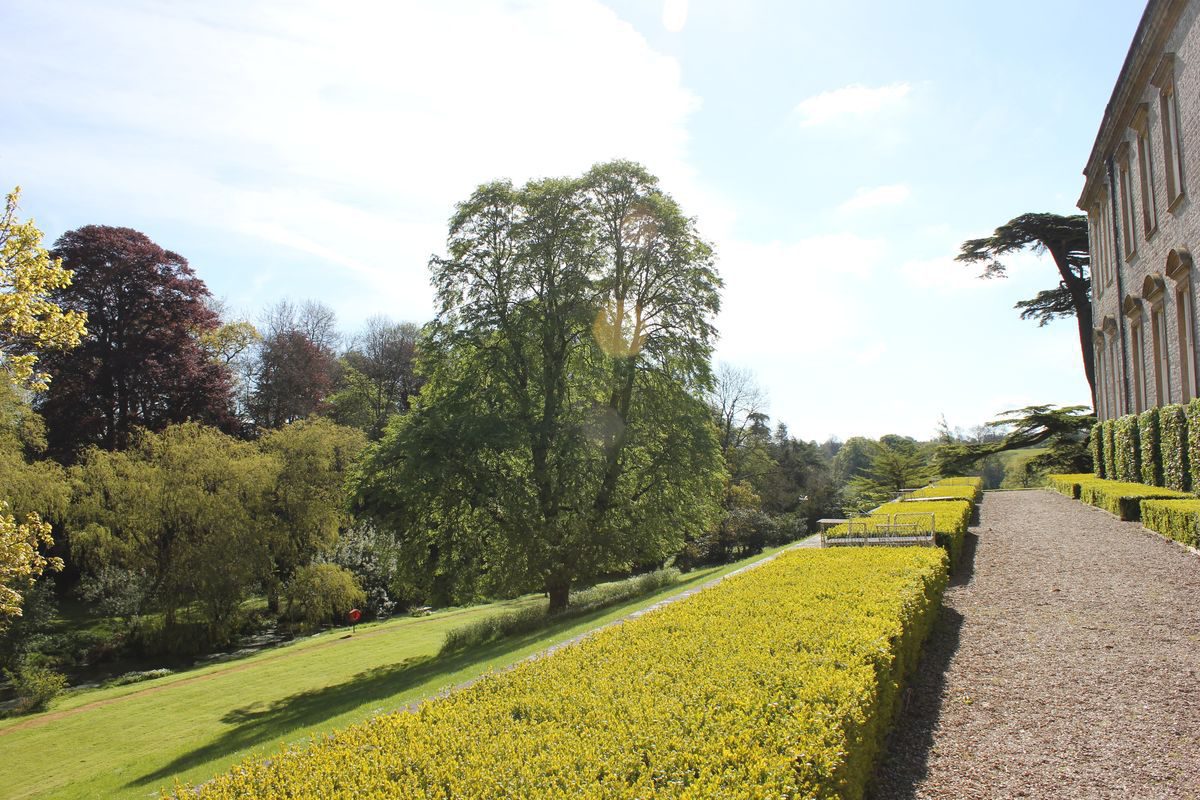
Ston Easton Park is situated immediately north-east of the village of Ston Easton, and to the east of the A37 road. The c 92ha site comprises c 5ha of gardens and pleasure grounds, and c 87ha of parkland and ornamental plantations. The northern and western boundaries of the site are formed by the A37 road, which passes through the village of Ston Easton on the south-west boundary of the park. The site is separated from the road by stone walls and hedges.
To the south the site adjoins the parish church of the Blessed Virgin Mary and Manor Farm, and is crossed by a minor road leading eastwards from Ston Easton to Clapton. A further area of park lies to the south of this road, bounded to the west by the A37 road and to the east and south by agricultural land. To the east the site is bounded by agricultural land. The site is divided into two approximately equal areas by a stream which flows from west to east through a steep-sided valley. The area to the north of the stream is elevated and slopes gently from north to south, affording wide views across the site and the surrounding land. The area to the south is generally level.
Entrances and Approaches
Ston Easton Park is approached from the A37 road to the west, at a point c 190m north of the junction of that road and Green Street. The entrance comprises a pair of stone piers which support wrought-iron gates set in the stone boundary wall. To the north of the entrance stands a small lodge, probably of late C18 or early C19 construction. Beyond the entrance, the tarmac drive sweeps north-east and east across the park for c 160m, to reach a junction from which a spur leads north to the mid C18 stables (listed grade II*) which stand c 50m south-west of the mansion.
From the junction the principal drive continues east for c 50m before turning sharply north to enter a gravelled carriage turn below the south façade of the house at its south-west corner. A further drive, the Frome Drive, leaves the south-east corner of the carriage turn and sweeps south-east before turning sharply south to pass along a valley on the south-east boundary of the park, emerging on to the minor road running east from Ston Easton to Clapton at a point c 160m east-south-east of the parish church. This drive formerly crossed the road, continuing south-west across a further area of park, to emerge on to the A37 road adjacent to a late C18 or early C19 lodge c 350m south of the parish church. In the early C19, a third drive led north-north-east from the south-east drive at a point c 300m south-east of the house, running north-east and north and crossing the valley north-east of the house. It then climbed gently north, parallel to the north-east boundary of the park, to emerge onto the A37 road adjacent to Cliff Lodge, an early C19 structure which stands immediately south of the junction of the A37 road and Marsh Lane. This drive partly survives as agricultural tracks, and as access to the late C20 Farrington Golf Club.
The pattern of drives corresponds closely to that shown by Repton on the plan accompanying his Red Book (1793), and subsequently on the Tithe map of 1840. The latter does not, however, show the north drive to Cliff Lodge, and if constructed, this approach appears to have fallen rapidly into disuse. Repton's proposal for a 'viaduct' to carry the north drive over a 'chasm' c 600m east of the house does not appear to have been implemented; Repton's design for this feature (Red Book 1793) is similar to a proposal he made for Endsleigh, Devon (qv) in 1814.
Repton seems to have developed the south-west drive from an existing approach shown on a survey of 1779, while the south-east or Frome Drive, considered by Repton to be the principal approach, was a new development. It is shown in the form proposed by Repton on the 1813 estate survey and the Tithe map (1840), and its route through the valley was intended by Repton 'to impress the mind with an idea of some pleasing variety of ground, where a portion of the lawn [south park] is naturally flat' (Red Book 1793). The mid C18 plan shows an approach from the south-west passing through an elaborate formal wilderness to reach a court enclosed by grass glacis south of the house. It is unlikely that this scheme, presumably prepared at the time of the construction of the house by John Hippisley-Coxe, was ever fully implemented (Bond 1998).
Principal Building
Ston Easton Park (listed grade I) stands on a terrace immediately south of a steep-sided valley which extends from east to west through the centre of the site. The house is rendered to resemble ashlar with stone dressings and rusticated quoins, and comprises two storeys. The south or entrance façade has a central block comprising seven bays, of which the outer bays project slightly, framing a central engaged Tuscan Doric portico. The attic storey is ornamented by a relief of the Hippisley arms, while urns articulate the parapet of the projecting bays. The central block is linked to a pair of two-storey square pavilions beneath pyramidal roofs by recessed two-storey wings. The north or garden façade is of plainer design, comprising ten bays, with a recessed block to the north-east. The ground-floor windows on this façade are surmounted by segmental pediments.
The house was begun towards the end of his life by John Hippisley-Coxe (d 1769), and is likely to have been completed by his son, Richard. The architect of the building, which incorporated C17 foundations, remains unknown. The house, which retains important Palladian-style interiors, was converted for use as a hotel in the late C20.
Gardens and Pleasure Grounds
The informal pleasure grounds are situated to the north of the house, occupying the steep-sided valley which crosses the site from west to east.
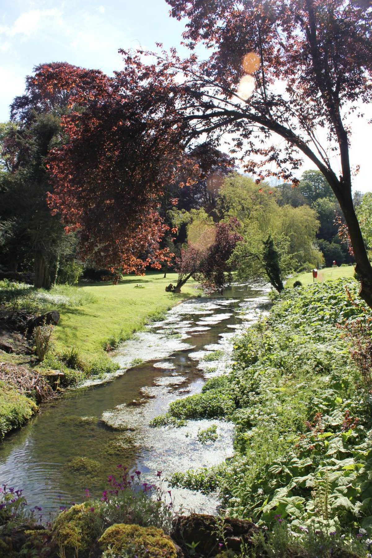
A paved terrace retained by a low stone wall ornamented with urns and edged by a low box hedge extends below the north façade of the house. Below the terrace, a north-facing grass slope drops to a stream which is artificially widened and enlivened by a series of shallow cascades. The grass bank is planted with mature specimen trees which help to frame northern and eastern vistas from the terrace. Beyond the stream a level area of lawn is backed by a mixed plantation on the south-facing valley side.
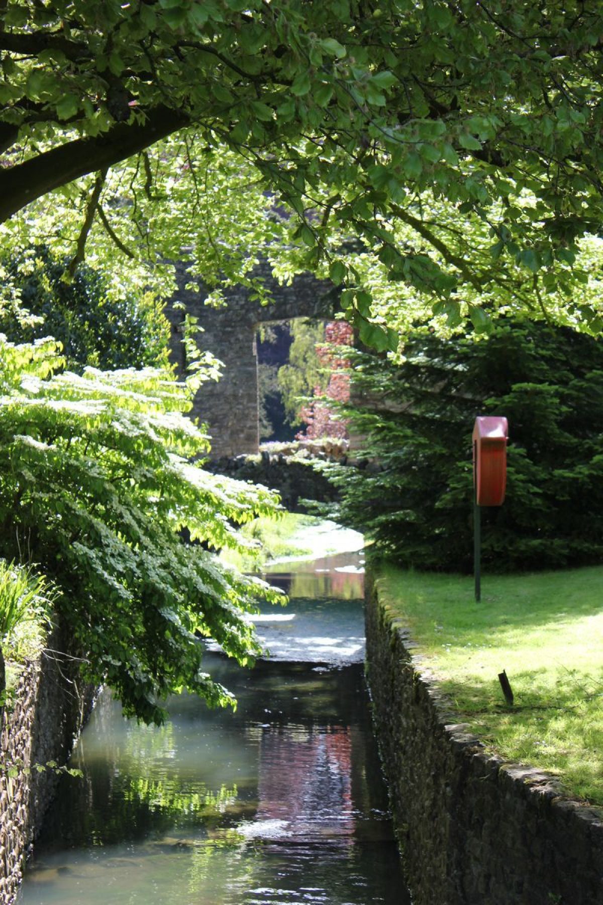
A gravel walk leads north-west from the terrace and drops gently north through a belt of mature yews and specimen trees which serves to screen the stables and kitchen garden to the north-west of the pleasure grounds. The walk crosses the stream on a stone bridge comprising a single perpendicular-gothic arch which spans a cascade. To the north-west the bridge incorporates a screen wall c 3.5m high in the form of a pair of gothic turrets, a central perpendicular-gothic opening, and flanking walls (all listed grade II). The wall serves to screen the kitchen garden from the pleasure grounds, while the central opening allows a view into the garden from the bridge and affords an open view when seen from the eastern end of the pleasure grounds. The bridge and screen wall appear to be of late C18 or early C19 construction, but while the cascade formed part of Repton's scheme of improvements, the bridge and wall are not described in his Red Book (1793).
From the bridge, a walk leads east parallel to the southern bank of the stream. After c 130m the walk turns north-east, crossing the stream on a further stone bridge (listed grade II) comprising a central segmental arch flanked by a pair of circular openings. This bridge appears to be of late C18 or early C19 construction but is not mentioned in Repton's proposals (Red Book 1793). The walk divides beyond the bridge, one branch traversing the south-facing valley side to reach the remains of an alcove seat or grotto built into the slope. The origins of this feature are unknown but it may relate to a structure shown in this position on the mid C18 garden plan, and certainly corresponds to a building marked on the Tithe map (1840). The other walk leads north-east to enter Terrace Wood following the course proposed by Repton for the north drive, and benefiting from southerly views across the stream and valley. The walk appears to have led to a structure, perhaps a summerhouse, on a bastion projecting north into the park c 160m north-east of the house (Tithe map, 1840); no trace of this structure survives above ground (2003).
The pleasure grounds assumed their present form in the late C18 and early C19 following advice received from Humphry Repton in 1792-3. When he came to Ston Easton, Repton found the valley to the north of the house filled by a 'stagnant pool that fills the whole bottom of the bason' (Red Book 1793). The pool was retained to the east by a dam which 'chokes up the mouth of the glen', obscuring the view down the valley. Repton considered that the area of 'flat lawn' or park to the north of the valley contrasted unfavourably with the south-facing slope above the water (ibid). Repton's scheme included the formation of clumps of trees on the slope to break the open prospect of the park, the draining of the pool, and the removal of the dam in order to open-up the valley to the east. This work appears to have been fully implemented and forms the basis of the pleasure grounds as they survive today (2003).
The pleasure grounds which existed prior to Repton's improvements appear to relate closely to those delineated on the mid C18 garden plan. This shows a terrace below the north façade of the house, and lawns sloping down to an irregular-shaped pool. Formal vistas cut through trees or shrubs gave a view north-west to a cascade beneath a bath-house at the western end of the lake, and north-east to a grotto set into the dam at the eastern end of the pool. A road passed along the northern bank of the pool, crossing the stream on a bridge below the dam. To the north of the pool, and on an axis with the house, a glade cut through trees on the south-facing slope was terminated by a small structure or statue. The broad outlines of this scheme survived to be recorded on a plan of 1779, while a plan of 1813 shows the effect of the implementation of Repton's scheme.
Park
The park comprises two distinct areas separated by the house and valley. The park to the south of the house is level and is now (2003) in mixed agricultural use, with several scattered mature parkland trees. A plantation on the boundary of the park c 200m south-west of the house screens the village from view, while the tower of the parish church c 640m south-south-west of the house serves as an eyecatcher. A scattered belt of trees extends along the drive parallel to the south-east boundary of the south park. A further area of park to the south of the minor road leading from Ston Easton to Clapton is in agricultural use. The south park assumed its present form in the late C18 and early C19. The plan of 1779 shows a smaller area of park to the south of the house, while Repton's scheme (Red Book 1793), the survey of 1813, and the Tithe map (1840) all show the park essentially as it survives today. The south-west boundary plantation formed part of Repton's proposals for improving the 'flat plain' of the south park (Red Book 1793).
The north park lies beyond the pleasure grounds and comprises a gentle south-facing incline. To the south, this area of park is enclosed by a belt of plantation and shrubbery which forms part of the pleasure grounds, while to the north the A37 road is screened by two blocks of plantation. The gap between these plantations appears to be an integral part of the late C18 or early C19 landscape design, allowing a glimpse of sky from the house and park, thus avoiding the sense of complete enclosure which Repton warned would be the effect of a continuous boundary plantation round the north park (ibid). The north park remains (2003) predominantly grass and pasture, with an area to the north-east forming part of the late C20 Farrington Golf Club's course. Some scattered parkland trees survive, particularly in the southern half of the park, while a tumulus on the south-west boundary is planted with a mature specimen tree to form a feature in the landscape. There are extensive southerly views from the north park towards the house, the south park, and the land beyond.
The north park was developed in its present form in the late C18 and early C19. The mid C18 garden plan shows an area of parkland to the north and north-east of the pleasure grounds, but does not indicate its full extent. To the west, the Bristol road, which forms the boundary of the park, is shown following a course considerably further east than its present route. The survey of 1779 shows an approximately rectangular park enclosure, considerably smaller than the present north park, to the north of the pleasure grounds, with a series of small field enclosures occupying the higher ground to the north.
The Bristol road had, by this date, been realigned to its present course, but another road ran south from a point c 130m south-west of Cliff Lodge, through an area which was subsequently imparked. Repton was concerned that the north park was too flat to be picturesque (Red Book 1793) and consequently appears to have advised the eastward extension of the park around North Lawn Cottage (the remains of which survive c 300m north-east of the house), to allow for the construction of the north drive which would benefit from wide easterly views towards Radstock (ibid). While some of his proposals for the north park appear to have been implemented, the 1813 estate survey and the Tithe map (1840) both suggest that the park was not extended to the east. The park today (2003) remains substantially as shown on the 1840 Tithe map.
Kitchen Garden
The kitchen garden is situated in the valley to the north-west of the house. Approximately elliptical on plan, the garden is enclosed by a tile-coped stone wall to the south and a brick wall to the north and is entered from the pleasure grounds at its south-east corner. A further, service entrance approaches the garden from the A37 road to the west. The eastern boundary of the garden is formed by the screen wall and bridge (listed grade II) which mark the western termination of the pleasure grounds, and by the late C18 gardener's cottage (listed grade II) which adjoins this wall to the north.
The garden is laid out with a series of box-edged vegetable beds to the west of a group of four early C20 glasshouses which occupy the centre of the site. To the south of the vegetable beds the north-facing grass slope is planted as an orchard, while a terrace below the north wall is the site of a C19 lean-to glasshouse. Further C19 lean-to glasshouses stand to the north of the free-standing structures. The stream, which later flows through the pleasure grounds, passes through the eastern end of the kitchen garden in a stone-edged rill before flowing beneath the bridge and screen wall. In the mid C18 the site of the kitchen garden was crossed by the Bristol road, and the mid C18 garden plan shows a kitchen garden to the south-east of the house; it is not known if this garden was ever constructed. By 1779, following the diversion of the road, the kitchen garden is shown in its present location and form. Repton's proposals did not affect the kitchen garden and it remains substantially unchanged on his plan (Red Book 1793), the 1813 estate survey, and the Tithe map (1840). The present internal layout of the garden dates from the late C20.
Maps
- Garden plan for Ston Easton, no date (mid-18th century) [copy on EH file]
- Estate survey, 1779 (DD/HI C/738), (Somerset Record Office)
- Estate survey, 1813 (DD/HI 264), (Somerset Record Office)
- Tithe map for Ston Easton parish, 1840 (Somerset Record Office)
- OS Surveyor's Drawing, 1811 (Somerset Record Office)
- OS 6" to 1 mile: 1st edition surveyed 1883, published 1885; 2nd edition revised 1902, published 1904; 1931 edition
Illustrations
- J Bonner, Stone Easton the Seat of Henry Hippisley Coxe Esqr (in Collinson 1791)
Archival items
- The Hippisley-Coxe family archive, including 18thh- and 19th-century estate surveys, accounts, and garden records is held in the Somerset Record Office (DD/HI)
- H Repton, Red Book for Ston Easton, 1793 (private collection)
Description written: December 2003
Amended: September 2004
Edited: November 2021
- Visitor Access, Directions & Contacts
Telephone
01761 241631Website
http://ston-easton-park.edan.ioAccess contact details
There are open days run for the National Gardens Scheme.
Directions
The park is on the A37 11 miles south of Bath and Bristol.
- History
The following is from the Register of Parks and Gardens of Special Historic Interest. For the most up-to-date Register entry, please visit The National Heritage List for England (NHLE):
In the medieval period the manor of Ston Easton belonged to the Augustinian priory of Bruton. At the Reformation, the manor was acquired by the Prior’s tenant, John Hippisley. The estate remained the property of the Hippisley family until the late 20th century.
17th century
In the mid-17th century, another John Hippisley married Margaret Preston of Cricket St Thomas, Somerset (see description of this site elsewhere in the Register). Their granddaughter married John Coxe of Leigh, Wiltshire, and the family descending from this union was known as Hippisley-Coxe. John Hippisley-Coxe (1715-69) began to rebuild a Tudor or earlier manor house which had been the family’s home in the 17th century. This building is said to have been incomplete at his death in 1769, when the estate was inherited by his son, Richard (1743-86). The new house was provided with an appropriate parkland setting, formed by diverting the Bristol road to a new course to the west, enclosing open fields and demolishing cottages to the south of the house, and exchanging land with a neighbour (Country Life 1945).
18th - 20th century
A mid-18th-century plan shows elaborate formal gardens around the house and a pool in the valley to the north; it is unclear to what extent this scheme was realised (Bond 1998). Richard Hippisley-Coxe appears to have completed his father’s work, selling the Cricket St Thomas estate in 1775, perhaps to finance his improvements, and making Ston Easton his principal residence. He died unmarried in 1786 and was followed in quick succession by two of his younger brothers, Charles (died 1788), and Henry (died 1795). Despite the straitened financial circumstances he inherited, Henry was able to commission Humphry Repton (1752-1818) in 1792 to produce a Red Book proposing improvements to the landscape around the mansion. This document, delivered in March 1793, suggested the formation of pleasure grounds in the valley to the north of the house, and various improvements in the park to the north, south, and east, but the proposals were largely unimplemented.
When Henry Hippisley-Coxe died in 1795, the male line of the family came to an end. The estate devolved upon his widow, Elizabeth Anne Horner of Mells, Somerset (see description of this site elsewhere in the Register), who subsequently married Sir John Cox-Hippisley Bt, a distant cousin of her first husband (Country Life 1945). Lady Hippisley exercised strict control over the estate finances and made several improvements to the house and gardens, perhaps including the completion of Repton’s scheme for the pleasure grounds. Sir John died in 1825, and Lady Hippisley continued to occupy Ston Easton until her own death, when it was inherited by a collateral branch of the family from Lambourn, Berkshire (CL 1945). The estate remained in their possession until the late 20th century, when it was divided and the house converted into a hotel.
21st century
Ston Easton Park was sold for £4m to private firm Von Essen Hotels in 2001 and then sold again to Hamilton Bradshaw in 2012.
Period
- 18th Century (1701 to 1800)
- Late 18th Century (1767 to 1800)
- Associated People
- Features & Designations
Designations
The National Heritage List for England: Register of Parks and Gardens
- Reference: GD1024
- Grade: II
Features
- Terrace
- Ornamental Bridge
- House (featured building)
- Description: The house replaced a Tudor manor.
- Earliest Date:
- Latest Date:
- Stream
- Key Information
Type
Estate
Purpose
Ornamental
Principal Building
Commercial
Period
18th Century (1701 to 1800)
Survival
Extant
Hectares
92
Open to the public
Yes
Civil Parish
Ston Easton
- References
References
- {English Heritage Register of Parks and Gardens of Special Historic Interest}, (Swindon: English Heritage, 2008) [on CD-ROM] Historic England Register of Parks and Gardens of Special Historic Interest
- Stroud, D., {Humphry Repton} (London: Country Life, 1962), p. 68 Humphry Repton
- Bond, J., {Somerset Parks and Gardens} (Tiverton: Somerset Books, 1998), pp. 73, 95 Somerset Parks and Gardens
- Pevsner, N., {The Buildings of England: South and West Somerset} (Harmondsworth: Penguin, 1958), pp. 265-6 The Buildings of England: South and West Somerset
- Collinson, J., (1791), p 155 History and Antiquities of the County of Somerset III
- (23 March 1945), pp 508-1; (30 March 1945), pp 552-5; (6 April 1945), pp 596-8 Country Life, 97