Introduction
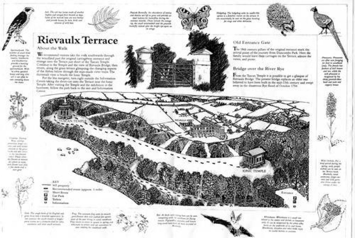
Rievaulx has a terrace walk and adjoining woodland. The half-mile walk offers views over the ruins of Rievaulx Abbey.
Terrain
The site lies on a ridge overlooking the valley of the River Rye and the remains of Rievaulx Abbey alongside it.
The following is from the Register of Parks and Gardens of Special Historic Interest. For the most up-to-date Register entry, please visit The National Heritage List for England (NHLE):
A terrace laid out in about 1758 with views of the valley of the Rye and the ruins of Rievaulx Abbey. The layout of the Terrace with the emphasis on unfolding views rather than formal axes was a departure which has been described as 'a landmark in the development of English Landscape style' (Jellicoe et al 1986) and 'a superlative example of large-scale landscape gardening' (Pevsner 1966).
Location, Area, Boundaries, Landform and Setting
Rievaulx Terrace lies immediately south and east of the village of Rievaulx in an area which is rural and agricultural. The c 23ha site lies on a ridge overlooking the valley of the River Rye and the remains of Rievaulx Abbey alongside it. The boundaries are formed by a road called Rievaulx Bank on the north side and fences around the precincts of the Abbey and the edge of Terrace Bank Wood on the west side. A fenced band of woodland runs along the east side of the site.
Entrances and Approaches
The entrance to the site is from the B1257 via a drive which leads south-west to a C20 shop and exhibition area. A path leads through woodland to a gap in the trees where there is a set of C18 stone gate piers with pedimented caps which leads onto the Terrace. This entrance seems to be contrived so that views of the temples and the Abbey ruins below are not immediately available and are discovered as the visitor moves from the entrance onto the Terrace. The Abbey is reached from the south end of Rievaulx Bank in Rievaulx.
The Duncombe family visited Rievaulx from their home at Duncombe Park, which lies c 3km to the south-east. There is a tradition that Thomas Duncombe wished to link the two sites more directly with a viaduct across the valley and the discovery of large quantities of dressed masonry in the valley which links Rievaulx to the Helmsley road tends to support the theory.
Principal Building
Rievaulx Abbey (listed grade I; scheduled ancient monument) is a Cistercian foundation of 1131 with most of the remains dating from the C13. The extent of the ruins and their good state of preservation is partially explained by the fact that there were absentee landlords in the years after the Dissolution. Subsequently there was a conscious desire to preserve the ruins for their romantic appeal. Writing of the site Pevsner says: 'for the picturesque traveller it is an exquisite feast' (1966).
The Abbey site is in a sheltered position on level ground on the east bank of the Rye. The well-preserved elements of the Abbey Church with its tall lancet windows are particularly prominent in views of the ruins from the Terrace. The site is in the guardianship of English Heritage (1998).
Gardens and Pleasure Grounds
The Terrace is articulated about two buildings of c 1758 thought to have been designed by Thomas Robinson (see for example Hussey 1967). The designs are based on models well known in the C18 through engravings in translations of Palladio, with the Ionic Temple recalling the reconstruction of the Temple of Fortuna Virilis in Rome and the Tuscan Temple the Temple of Vesta at Tivoli.
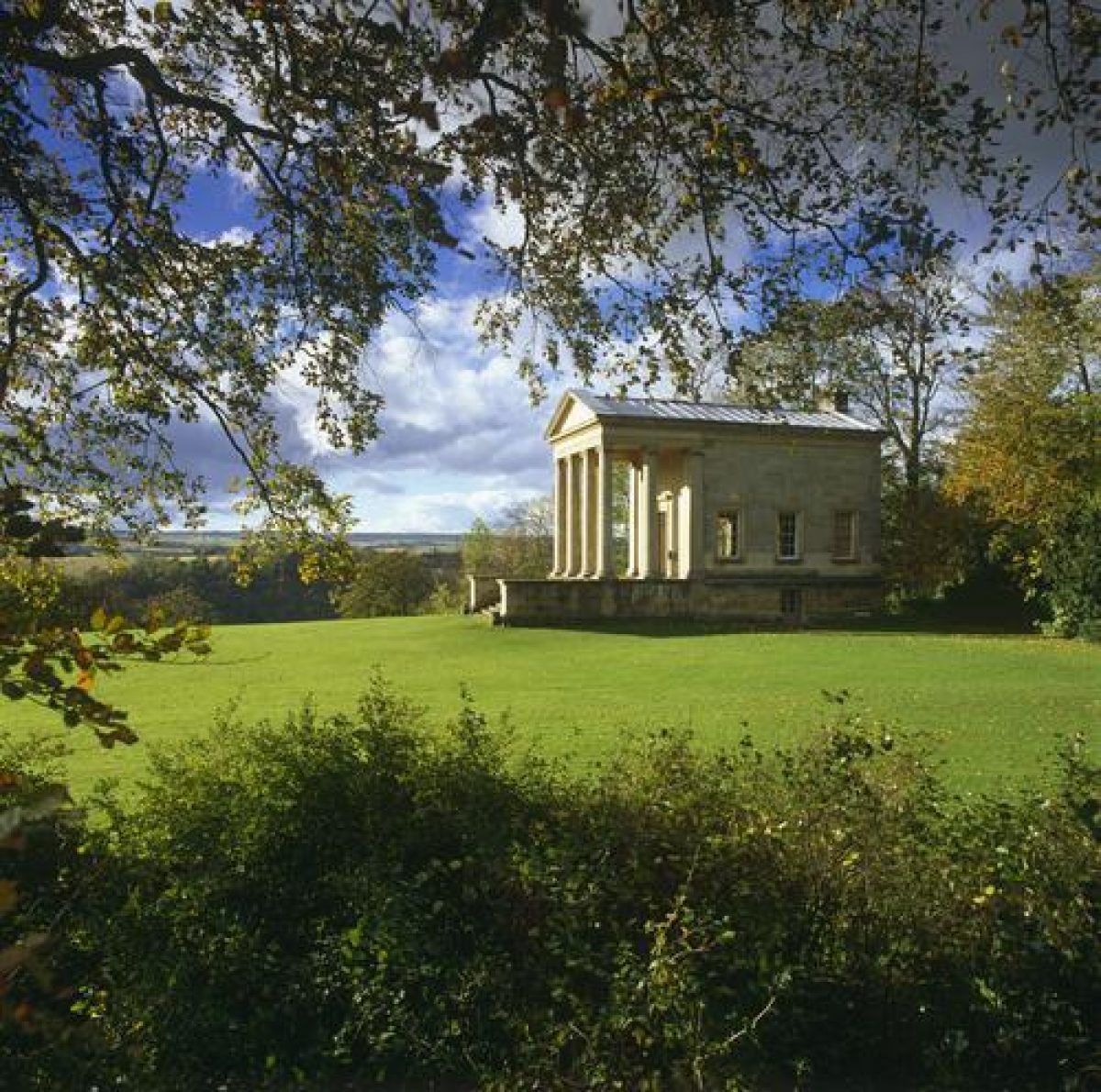
The Ionic Temple (listed grade I) stands on a platform at the north end of the Terrace. A flight of stone steps on the south side of the building leads up to a pedimented portico of unfluted Ionic columns from which there are views south along the Terrace. The building was heated, with a single room above a two-room service basement which provided accommodation for a gardener and facilities for preparing food. The upper room is richly decorated and contains some original furnishings (1998).
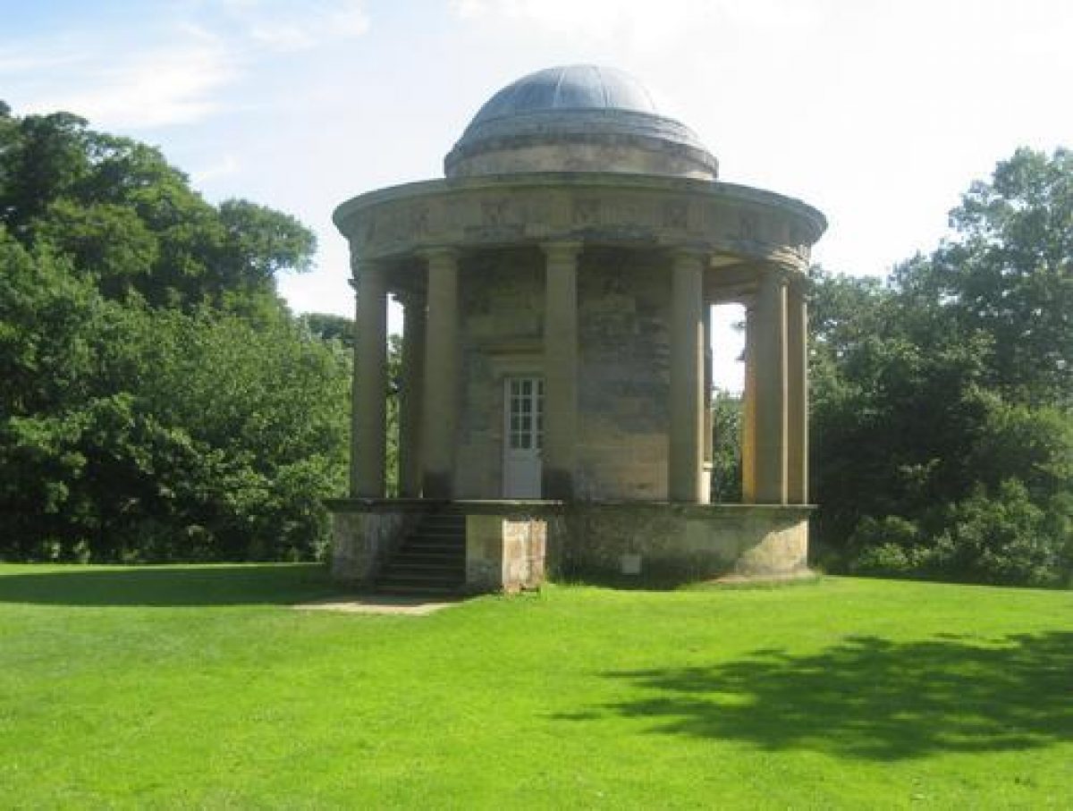
At the south end of the Terrace the Tuscan Temple (listed grade I) is a circular drum with a dome encircled by detached Doric columns supporting an entablature with triglyphs and bucrania. The interior has a painted ceiling with elaborate plasterwork and medieval floor tiles from the Abbey ruins. Although the order used is Doric the Temple seems always to have been called the Tuscan Temple, probably because the columns have no bases.
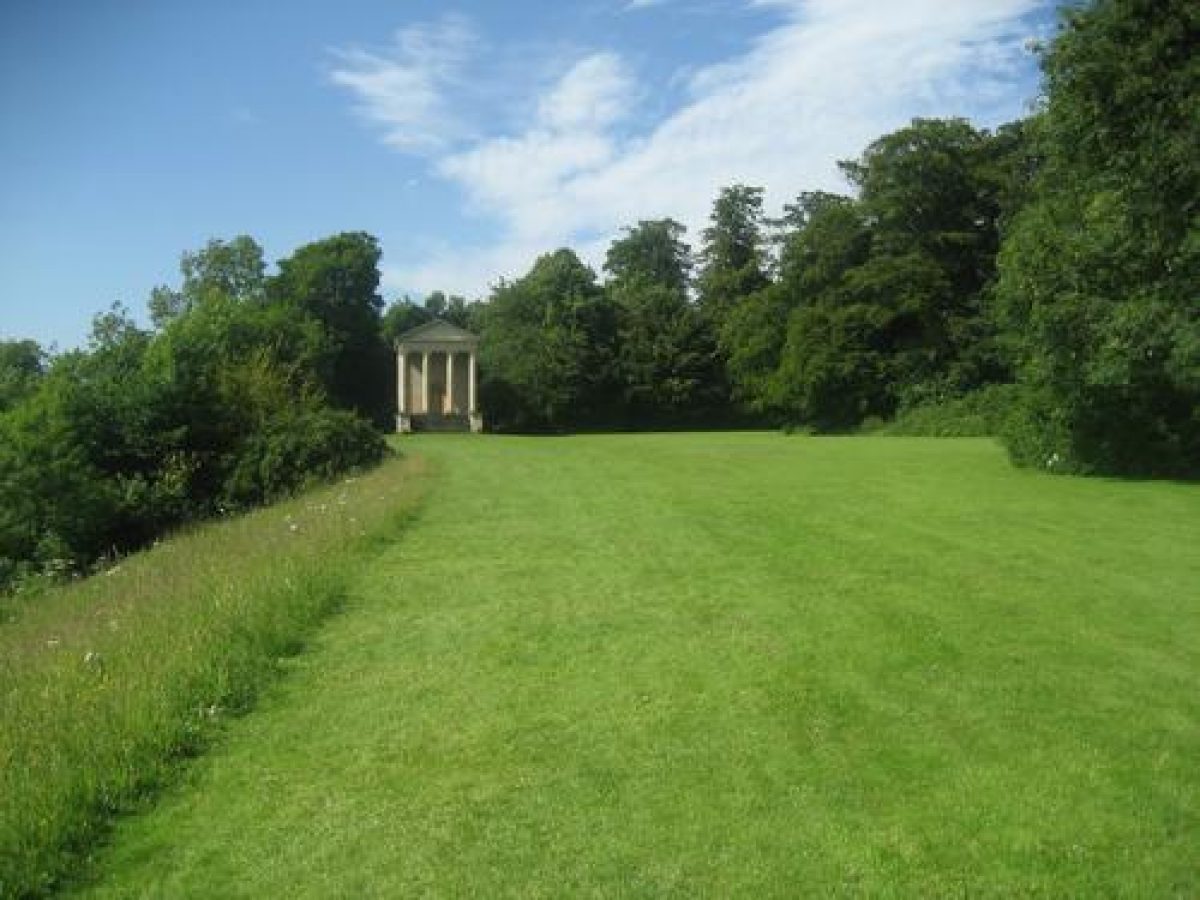
The grassed terrace follows a curving course between the two temples which are c 700m apart and not fully visible from one another. Each one comes into full view of the other, framed by trees, as a promenade is made along the Terrace. The band of woodland which acts as a backcloth on the east side of the Terrace has a waved edge which emphasises the curve of the Terrace. On the west side there is a curving scarp and the land falls very steeply to the west. The slope is covered with trees (largely replanted, late C20) and thirteen vistas have been cut through them recreating vistas described in the C18. The result is a sequence of views of the valley and the river backed by the tree-clad slopes of Ashberry Hill with the Abbey ruins in the foreground. An early C19 guide (quoted in guidebook 1992) to the site recommended turning to the south from the central entrance and walking to the Tuscan Temple before returning and continuing to the Ionic Temple. The Tuscan Temple is also the starting point for Arthur Young's 1771 description of the site (ibid).
A vista from the Tuscan Temple gives a glimpse of Rievaulx Bridge (listed grade II) c 400m to the south-west, and there are changing views of the valley as the visitor walks northwards. The Abbey ruins first appear in a view of the tall lancets of the Abbey church's (liturgical) east end and the disposition of the ruins and surrounding scenery changes as the visitor proceeds. As the Ionic Temple is approached there are views directly to the north transept of the church with tall lancet windows. In addition to the views into the valley there are spectacular long-distance views to the west along the whole length of the Terrace, over Ashberry Hill and to open land beyond.
Young comments on the changefulness and variations in the view. At one particular spot he describes 'scattered trees appearing among the ruins in a stile too elegantly picturesque to admit description: It is a casual glance at a little paradise, which seems as it were in another region'. This aptly sums up the relationship of the Terrace with the ruins, one in which the invitation is to view them from a distance and to see them in the context of changing landscape views, rather than explore them at close quarters.
Maps
- OS 6" to 1 mile: 1st edition surveyed 1856
Description written: October 1998 Amended: March 1999
Register Inspector: CEH
Edited: October 1999, December 2022
- Visitor Access, Directions & Contacts
Telephone
441439748283Access contact details
The site is open daily between February and October. For more information visit the National Trust website.
Owners
The National Trust
Heelis, Kemble, Drive, Swindon, SN2 2NA
- History
The following is from the Register of Parks and Gardens of Special Historic Interest. For the most up-to-date Register entry, please visit the The National Heritage List for England (NHLE):
17th-18th Century
The Terrace at Rievaulx is on land owned by Rievaulx Abbey until the Dissolution of the Monasteries when it was granted to Thomas Manners, Earl of Rutland, who already owned the neighbouring estate at Helmsley. The estates passed to George Villiers, first Duke of Buckingham, who married the heiress Katherine Manners.
After the death of the second Duke of Buckingham in 1687 the estates were sold to Sir Charles Duncombe who bequeathed them on his death in 1711 to his nephew Thomas Duncombe who laid out the terrace at Duncombe Park in 1718. His son, the second Thomas Duncombe, laid out the Rievaulx Terrace in about 1758.
19th-20th Century
The estate remained in the family, who were created earls of Feversham in 1868. Following the death of the last Earl in 1963 the site passed to the National Trust in whose ownership it remains (1998), while the ruins of the Abbey were acquired by the Government in 1917 and passed into the care of English Heritage, in whose ownership they remain.
- Associated People
- Features & Designations
Designations
The National Heritage List for England: Register of Parks and Gardens
- Reference: GD2074
- Grade: I
Features
- Abbey (featured building)
- Description: Rievaulx Abbey (listed grade I; scheduled ancient monument) is a Cistercian foundation of 1131 with most of the remains dating from the C13.
- Ionic Temple
- Description: The ionic temple was used as a banqueting house.
- Earliest Date:
- Latest Date:
- Temple
- Description: Tuscan Temple (listed grade I) is a circular drum with a dome encircled by detached Doric columns supporting an entablature with triglyphs and bucrania.
- Earliest Date:
- Latest Date:
- Gate Piers
- Description: C18 stone gate piers with pedimented caps which leads onto the Terrace.
- Bridge
- Description: Rievaulx Bridge (listed grade II)
- Steps
- Description: A flight of stone steps on the south side of the building leads up to a pedimented portico of unfluted Ionic columns.
- Terrace
- Description: The Terrace is articulated about two buildings of c 1758 thought to have been designed by Thomas Robinson.
- Key Information
Type
Garden
Purpose
Ornamental
Survival
Extant
Hectares
23
Open to the public
Yes
Civil Parish
Rievaulx
- References
References
- {English Heritage Register of Parks and Gardens of Special Historic Interest}, (Swindon: English Heritage, 2008) [on CD-ROM] Historic England Register of Parks and Gardens of Special Historic Interest
- Jellicoe, Sir G. et al (eds), {The Oxford Companion to Gardens} (Oxford: Oxford University Press, 1986), p. 471 The Oxford Companion to Gardens
- Pevsner, N., {The Buildings of England: Yorkshire The North Riding} (Harmondsworth: Penguin, 1966), pp. 299-307 The Buildings of England: Yorkshire The North Riding
- Keevill, Graham {A second paradise of wooded delight: Rievaulx Abbey, North Yorkshire: conservation plan} (1999) A second paradise of wooded delight: Rievaulx Abbey, North Yorkshire: conservation plan
- Young, A., (1771), pp 79-87 [quoted in guidebook] A Six Months Tour Through the North of England, vol 2
- Hussey, C., (1967), pp 140-6 English gardens and landscapes 1700-1750
- National Trust (1992) The Rievaulx Terrace, guidebook
- Related Documents
-
CLS 1/153/1
Final Draft/ Conservation Plan, Vol.1 of 2: Main Report - Hard copy
Caroe & Partners - 2000
-
CLS 1/153/1