Introduction
Pirton Park was previously part of the Croome Court estate. The fallow deer park was landscaped by Capability Brown whilst he worked on Croome. Features include cedars and limes planted in the mid-18th century.
www.historicengland.org.uk/listing/the-list
A deer park landscaped in the 1760s by Lancelot Brown as part of his landscaping works at neighbouring Croome Court (qv).
DESCRIPTION
LOCATION, AREA, BOUNDARIES, LANDFORM, SETTING
Pirton Park lies west of the hamlet of Pirton, 2.5km north-west of Croome Court. The M5 motorway passes 200m west of the south-west end of the park, and although its traffic is relatively unobtrusive visually, the noise it generates does intrude on the parkland, especially its higher, north-western part, where Pirton Tower stands on a ridge. The area here registered is c 92ha.
ENTRANCES AND APPROACHES
Several footpaths bisect the park, including one which leads from Pirton Court to the east. This presumably represents the principal historic approach.
PRINCIPAL BUILDING
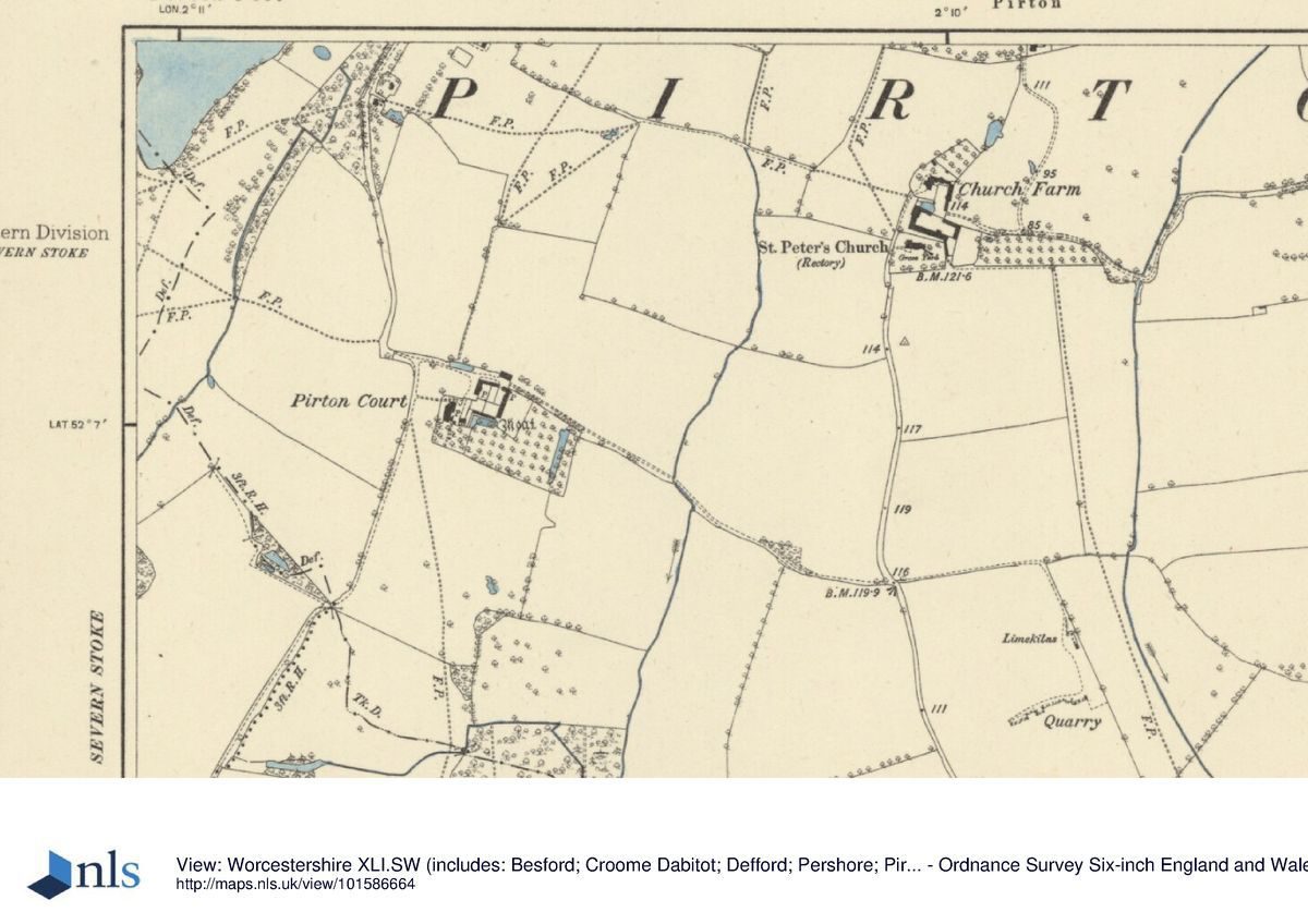
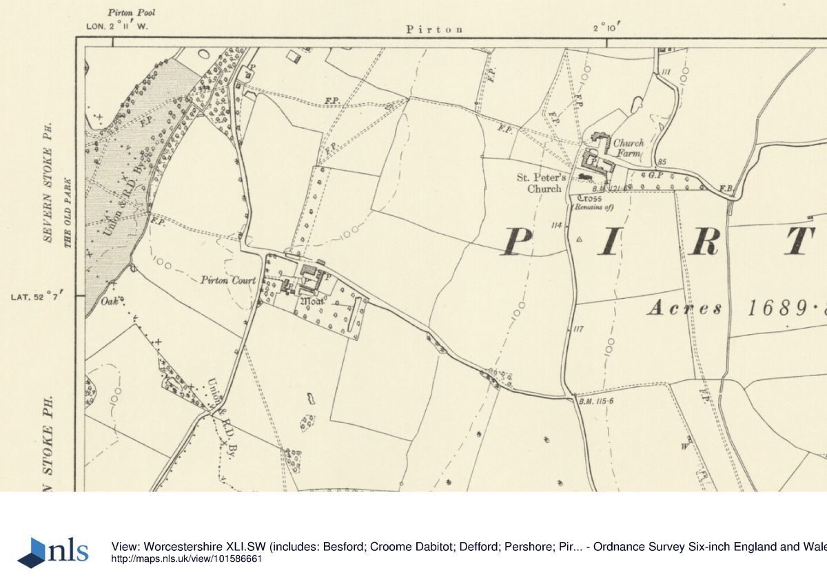
Pirton Court (listed grade II*), outside and 400m east-south-east of the east boundary of the park, is a large, irregular, early C17 house, timber-framed on stone foundations. It was an important house on the Croome estate and it is thought that Lord Coventry may have lived here while Croome Court was transformed in the early 1750s. In the mid 1890s it was rebuilt for the coming of age of the ninth Earl's son.
PARK
The topography of Pirton Park, or the Fallow Deer Park, is dominated by a pronounced ridge which runs from south-west to north-east through it, north-west of its centre line. Running along its crest, south-west of Pirton Pool, is a line of mature cedars of Lebanon, probably planted in the 1760s, interplanted with a few limes. A ride along the front (south-east) of the trees leads to Pirton Tower (listed grade II), situated 400m south of Park Farm. Designed in 1797 by James Wyatt (d 1813), it was built in the same year by the mason William Stephens who was paid £87 9s for work at the Ruin at Park Farm (Croome Estate Archive). It takes the form of a high, broken rubble wall with a narrow, circular central limestone ashlar tower with splayed base. Access to the Tower is from the rear; an internal stone staircase has collapsed. The Tower is an important part of the Croome landscape scheme and was a notable point on the late C18/early C19 Ten Mile Ride. The Tower stands on the highest point in the park and is intervisible not only with Croome Court itself, but also the park and church which lie to the south. To the north, on a minor ridge c 400m distant, is Park Farm. This stands on the edge of the registered area, at the north-west angle of the park. From the Tower it forms something of an eyecatcher, along with the tree-covered mound, possibly a barrow, on its east side. The farm occupies the site of a Keeper¿s House shown on a plan of the park prepared probably by Lancelot Brown in 1764.
Behind the Tower the ground falls steeply away down a bank, shown as Rabbit Bank by the OS, on which there is a plantation. To the south-east of the Tower the ground slopes away to the south-east, across what is now (1999) arable farmland. Intruding into the more level, south-west part of the park is a race course (disused). This is aligned south-west to north-east and extends beyond the registered area to the south where it is truncated by the M5.
The north-east quarter of the park, where again the ground slopes down from north-west to south-east, is dominated by Pirton Pool, an irregularly shaped piece of water 700m long from north to south and a maximum of 250m wide. This is retained by a long contour dam, in part stone walled, along its south-east side. This was reconstructed in 1976 when the Pool underwent a major restoration. Pirton Covert runs northward from a point midway along this side, providing a backdrop to the water dominated by a group of mature cedars of Lebanon, again probably planted in the 1760s. Drainage work in the covert was accounted for in 1782 (Croome Estate Archive). Mature oaks run along the south end of the south-east bank of the Pool. East and west of the south end of the Pool is permanent pasture with a scattering of parkland oaks. West of the south end of the Pool, under the permanent pasture, is an extensive area of partly ploughed-out ridge and furrow. Among other earthworks is what appears to be a length of hollow-way.
From the early C14, documents mention the great fishpond on the waste ('le graunt viver en le wast', VCH 1924), presumably the predecessor of Pirton Pool. The Fallow Deer Park was valued in 1687, while in 1712-13 deer were transferred between the two deer parks, that is the Fallow Deer Park and the Red Deer Park 2km south of Croome Court (Antony Muniments). In 1713 a new contract was made with William Thorniloe, the exisiting Keeper, who was henceforward to serve as Keeper of his Lordships Parks for £30 pa and the right to keep two horses, two cows, and two rung pigs. He was forbidden to remove wood without permission, and was in lieu provided with coal. His duties, with his assistant, were to maintain the park fences, `kill beef, mutton, etc', provide shot to kill the deer, and to go to fairs and markets to buy or sell cattle or horses (Croome Estate Archive; Antony Muniments). On the death in 1719 of Gilbert, fourth Earl of Coventry, the Fallow Deer Park was estimated to comprise 200 acres (c 81ha) and was stocked with deer.
The estate accounts of 1757-73 record that sixty oaks were stocked in the Fallow Deer Park in 1763, the same year that John Broome was sent to survey part of Pirton Heath for Lancelot Brown. Brown himself prepared a plan for Pirton Park c 1764. This shows the line of 'The old park pale' enclosing a slightly smaller area than that here registered.
REFERENCES
Victoria History of the County of Worcester IV, (1924), pp 180-2
C Beresford, Croome Court: Historic Landscape Survey, (report for National Trust, 1996)
Maps
(?) Lancelot Brown, Plan of Pirton Park, c 1764 (private collection)
Archival items
Details of the extensive Croome Estate Archive are given in Beresford (1996). Relevant items include:
Valuation of 1687 (Estate Box 1, ES12/3); Account Books, 1757-73; Details of work at Park Farm (Family Box 14, F58). Antony Muniments (CVA/Y/29; H3/27).
Description written: January 1999
Register Inspector: PAS
Edited: June 2004
- Visitor Access, Directions & Contacts
Access contact details
Opening times vary seasonally. Please see the website for details.
Directions
Nine miles south of Worcester via the A38 and the B4084.
Owners
The National Trust
- History
The following is from the Register of Parks and Gardens of Special Historic Interest. For the most up-to-date Register entry, please visit the The National Heritage List for England (NHLE):
www.historicengland.org.uk/listing/the-list
HISTORIC DEVELOPMENT
Pirton Park occupies what in the C14 was described as a waste, and which may have been the location of a C13 warren. The park may have been created in the C17, and was apparently well established when valued in 1687, the date of the first-known documentary reference (Croome Estate Archive).
The Coventry family became established in Worcestershire in the late C16, and were created earls in 1697. The sixth Earl, who inherited in 1751 and died in 1809, was foremost among the 'Earls of Creation', noblemen who developed their estates under the influence of classical philosophies and the Grand Tour. His long tenure of the Croome estate, of which Pirton formed a part, saw the full development of the landscape park around a rebuilt house, and Croome's recognition as one of the greatest landscape creations of the age. Lancelot Brown (1716-83) was employed there from 1750, rebuilding the house and laying out the park. Pirton Park (or the Fallow Deer Park), a medieval deer park, was landscaped by Brown in the mid 1760s, effectively as a satellite of what had become the main park at Croome, around the Court itself. Pirton is intervisible with Croome Court and its landscape 2.5km to the south-east, and in 1797 Pirton Tower was built on the park's skyline as an eyecatcher.
The family remained at Croome until 1948, when the house was sold for institutional use. In 1996 the main part of the parkland at Croome, although not the house, was purchased by the National Trust. Pirton Park remains (1999) in private hands.
- Associated People
- Features & Designations
Designations
The National Heritage List for England: Register of Parks and Gardens
- Reference: GD4169
- Grade: II
Features
- Tower
- Description: In 1797 Pirton Tower was built on the park's skyline as an eyecatcher.
- Earliest Date:
- Latest Date:
- House (featured building)
- Description: The house was re-built by Lancelot Brown from 1750.
- Earliest Date:
- Key Information
Type
Park
Purpose
Agriculture And Subsistence
Principal Building
Domestic / Residential
Survival
Part: standing remains
Hectares
92
Open to the public
Yes
Civil Parish
Pirton
- References
References
- {English Heritage Register of Parks and Gardens of Special Historic Interest}, (Swindon: English Heritage, 2008) [on CD-ROM] Historic England Register of Parks and Gardens of Special Historic Interest
- Willis-Bund, J. {Victoria County History: Worcester, Volume 4} (London: Archibald Constable, 1924) 180-2 Victoria County History: Worcester, Volume 4