Introduction
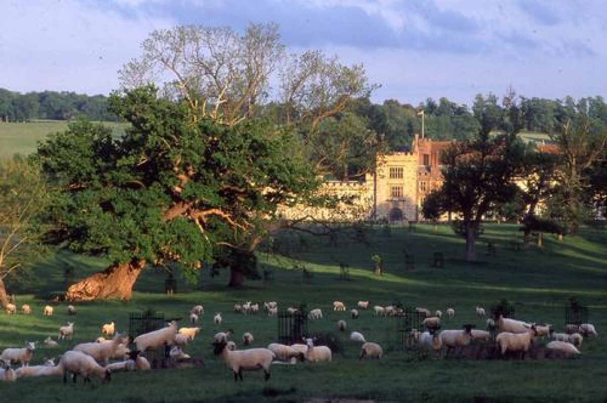
Penshurst Place is a medieval deer park dating from around 1346. The park of 178 hectares surrounds the formal walled gardens of four hectares. The wider estate is 1000 hectares in size.
Terrain
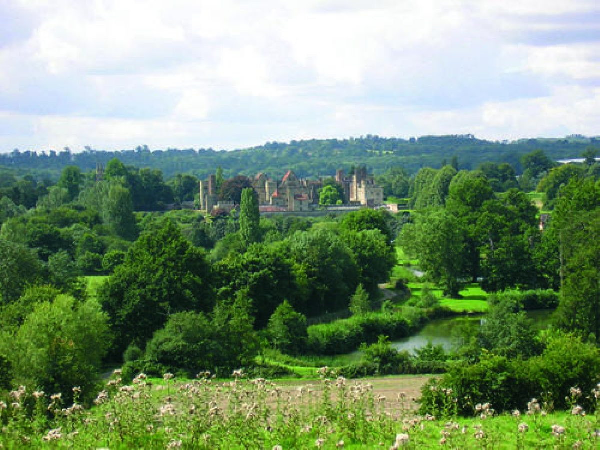
The house and formal garden lie on the level floor of the Medway valley. North and north-west of the house the parkland is laid out on land which forms a gently rising contoured bowl.
Penshurst Place is undoubtedly one of Kent's and the nation's finest historic houses and gardens, set in wooded parkland and grounds of very high quality. New planting on the estate and development of the gardens are part of a vigorous programme of planning for the immediate and the long term.
One can see the tight, formal structure of the gardens, based on the 16th- and 17th-century format before gardens tended to be opened up and allowed to lead into the surrounding countryside. Much of this area would have been orchards and kitchen gardens.
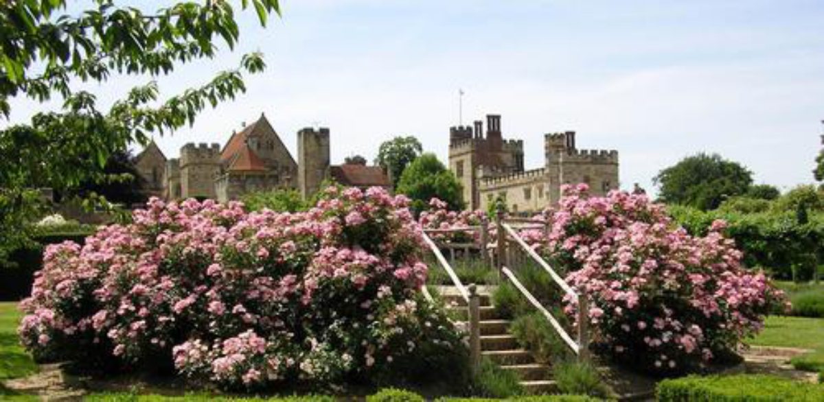
The Italian garden is the greatest open space in the gardens, taking the form of a large parterre on the south side of the house and providing a fine platform from which to view the splendid south elevation of the building. The garden's geometric designs were laid out on Devey's advice in the middle of the last century by the second Lord De L'Isle and Dudley when he had succeeded his father. It consists of low, clipped, box hedges enclosing beds planted throughout with the pink cluster rose ‘Elizabeth Arden', with a central oval fountain and raised walks and terraces on the west and north sides.
Other enclosed areas include the rose spring/autumn and nut garden. There is a ha-ha separating the house from the parkland to the north, and a lime avenue from the house north-east to the old farm buildings (now a museum) and venture playground skilfully hidden from the house.
The garden fell into disrepair during World War 2 and it was not until the mid-1960s that the 1st Viscount, having devoted much of his attention to repairing war damage to the house, was able to begin to re-model the interior of the many garden ‘rooms', each of which has a season at its best.
These individual gardens include a border to a design by Lanning Roper, a white and grey garden designed by John Codrington, a Theatre Garden, a peony border and a grand Union Flag design in red and white roses and blue lavender. Shortly before his death in April 1991, the Viscount installed a Naiad statue in the magnolia garden in memory of his first wife Jacqueline, the inscription around the base is one of Cattullus, from which work it is thought that Sir Philip Sidney got the idea for his best-known sonnet Astrophel and Stella. Sir Philip Sidney makes reference to the gardens at Penshurst in his ‘Arcadia', as does Ben Johnson in his works.
Following the storm of October 1987 the 1st Viscount De L'Isle restored the parkland and recreated the 13th-century fishponds to the east of the gardens. An arboretum is planned on the eastern shore of the largest pond as a memorial to the 1st Viscount, the trees being provided by the many friends and organisations that he worked with throughout his distinguished career.
The park and house make a unique and very important contribution to the very high quality landscape in the Penshurst area. Adjoining estates have been largely broken up, for example, Redleaf, where the wooded character is still continued, but without the ‘intact' quality as at Penshurst.
The following is from the Register of Parks and Gardens of Special Historic Interest. For the most up-to-date Register entry, please visit the The National Heritage List for England (NHLE):
www.historicengland.org.uk/listing/the-list
A 16th- and 17th-century walled garden, restored and developed in the 19th and 20th centuries, set within a medieval deer park with additional surviving 18th- and 19th-century landscape features.
DESCRIPTION
LOCATION, AREA, BOUNDARIES, LANDFORM, SETTING
Penshurst Place lies to the west of the B2188, c 5km south-west of Tonbridge and on the immediate north-east edge of Penshurst village. The registered site comprises a formal walled garden of c 4ha and a further c 178ha of parkland and woodland. The house and formal garden lie on the level floor of the Medway valley, the river running from south-west to north-east some 100m beyond the site's southern boundary. North and north-west of the house the parkland is laid out on land which forms a gently rising contoured bowl, from the rim of which there are extensive views to wooded ridges on the south-east side of the Medway and westwards to the Eden valley and the Sussex Weald. Woodland encloses the site to the north. Penshurst Road skirts the immediate west and north boundaries while to the east the site's woodland and farmland, enclosed by an avenue of trees and agricultural fencing, merge into a similar landscape beyond. To the south a fringe of trees encloses the site from the open pasture landscape of the river valley.
ENTRANCES AND APPROACHES
The present principal private entrance, which seems to have been established in the C19 with the building of North Lodge (probably (Newman 1969) by J B Rebecca, listed grade II), is from Penshurst Road, c 200m north-west of the house. The drive follows an easterly route then turns south to approach the King's Tower on the main entrance front across an apron of lawns enclosed within mature yew hedges and a walled ha-ha. The western length of the ha-ha was built by 1833 (anon sketch reproduced in Colvin and Moggridge 1994); the remainder of it and the present turning circle were complete by 1866-9 (survey date of OS 1st edition). Kip's early C18 view (Harris 1719) shows the house approached from both the north and east boundaries by formal avenues which still existed in 1758 (Eyre). C18 and early C19 views (see Colvin and Moggridge 1994) of the north front show open parkland extending up to the house until the reintroduction of the present enclosure. The present public entrance is at the southernmost corner of the site along a drive which enters at a gatehouse (mid C19 but incorporating older material, listed grade II) and runs for 380m parallel to the south wall of the garden before turning northwards to the car park and entrance buildings at the former Place Barn Farm.
PRINCIPAL BUILDING
Penshurst Place (listed grade I) lies in the south-west corner of the site and forms a visual ensemble, when viewed from the park, with St John the Baptist's church, 60m to the south-west. The house is built in sandstone of varying colours, with some brickwork; the elevations are mostly battlemented but with some steeply pitched roofs visible. The plan of the house is extensive: the oldest part, the hall house or Baron's Hall built in 1341, forms the core, to the south-west of which a second hall, known as the Buckingham Wing, was added in the mid C15. The towers and sections of curtain wall which surround the house survive from the complete fortification of his manor house by Sir John Devereux in 1392 (Newman 1969; CL 1972). Considerable alterations took place in the C16: the south-west wing with an upper long gallery was added in 1574-5 and the King's Tower, in the centre of the north front, was built or remodelled as an entrance tower in 1585 (Newman 1969). The north front and part of the west front were refaced by J B Rebecca in 1818 and the stable range, with wrought-iron gates of c 1729 brought from Wingerworth Hall (ibid), added east of the King's Tower in 1834. Further extensive restoration was carried out by George Devey (1820-86) in the mid C19 and again after war damage in 1945.
GARDENS AND PLEASURE GROUNDS
The formal gardens lie within a slightly south-eastward sloping rectangular walled enclosure (listed grade II*), built in the early C16 and C17, of which the house occupies the western quarter. The enclosure is quartered by two main axes, recreated in the 1850s, the longer running south-west to north-east and the shorter south-east to north-west. Gardens existed on the site in the C14; the present main divisions and axes were established by the beginning of the C18, as shown on Kip's view (Harris 1719) although these may date from the C16 or C17 (guidebook). After a period of neglect in the C18 the gardens were restored in the 1850s by the second Lord De L'Isle and the architect George Devey who modelled his work closely on Kip's view.
The house opens from the south-east front onto a grassed courtyard with, on its south side, the Garden Tower (listed grade I), which overlooks the southern quarter of the garden. The south-west half contains the Italian Garden, laid out in the 1850s by Devey on a level platform dating from the late C16 with a raised terrace walk of the same date along its south-west side (ibid). The central focus is an oval lily pond (designed to appear from the house as a perfect circle) set within a garden quartered and surrounded by gravel paths and four rectangular symmetrical panels edged and infilled with box and bedding. The north-east half of this quarter, separated from the Italian Garden by high yew hedges, is itself subdivided by hedges into two enclosures: the one to the north-west is laid out with spring and autumn borders beneath trained nut trees while the Rose Garden to the south-east is laid to a formal design of purple and grey plants with standard and bush roses, designed by John Codrington in the 1960s (CL 1972). The two gardens are divided by a broad path lined with borders of foliage plants, designed by Lanning Roper in 1968 (under restoration in 1997). To the east of these gardens the main paved, south-east to north-west axis is flanked by wide herbaceous borders backed by fruit trees and yew hedges and is focused at the south-east end on the view through wrought-iron gates in the garden wall. At the north-west end, at the crossing with the south-west to north-east axis, is a small paved garden with a pool and four clipped plum trees.
The eastern quarter has mainly been developed since 1945 on the site of the former kitchen garden, although a number of the yew-hedged subdivisions survive from their planting in the 1850s. A long border of peonies and lilacs runs along the south-east garden wall; abutting it to the north-west and enclosed by hedges are two orchard gardens, one with formal rows of trees surviving from before 1945, the other, designed by John Codrington (guidebook), planted with Kentish cobs and crabs around a central glade with a rustic pergola supporting climbing plants. North-west of the formal orchard are three separate, hedged enclosures, developed in the 1970s to designs by John Codrington. From the west the first is the Magnolia Garden, with a central statue, laid out on the site of the former glasshouses (ibid). The second is the Stage Garden with a grass theatre and ramp designed by Lord De L'Isle, and the third a grey and silver garden. The long south-west to north-east axis runs along the north side of these gardens from the house to the hedged enclosure containing Diana's Bath (50m distant). The rectangular stone basin, shown in this form on Kip's view (Harris 1719) and all subsequent maps, was restored in 1890. The axial path, flanked by clipped domes of yew, terminates at the north-east garden wall in a small pool (guidebook).
Of the northern quarter, the south-west half is laid out as a kitchen garden flanked on the north-east side by an apple avenue while the north-eastern 0.8ha contains the Union Flag Garden, the flag laid out in a pattern of roses and lavender, surrounded by pleached lime trees and overlooked by a small viewing mount set in a rectangle of pheons (broad arrowheads) depicted in dwarf box.
PARK
The park lies to the north and north-east of the house and walled garden, on ground rising to the rim of the contoured bowl which then extends northwards over a higher plateau. Within the bowl, the western half is grazed pasture, open in character with a scatter of clumps and individual trees and, towards the northern end, small areas of woodland. The eastern half is under arable cultivation with two major wooded clumps and a few individual trees. On the plateau north of the rim the majority of the parkland is planted with sweet chestnut coppice and coniferous forestry. A private deer park is first mentioned at Penshurst in 1290 and the whole of the present park covers the site of the paled medieval Old Park, shown on Burgess' survey of 1740 (Colvin and Moggridge 1994). Kip's view (Harris 1719), although compressing the landscape, confirms the appearance of the park in the early C18 and its complete separation from the formal garden. The enclosure of the east side of the park for agricultural use occurred between 1743 (Estate valuation, reproduced in Colvin and Moggridge 1994) and 1758 (Eyre plan). The Tithe map of 1842 shows the present landscape structure of the park established, with the new areas of woodland in the eastern half. Park woodland had expanded further by the late 1860s (OS 1871), although only one plantation had encroached on the northern plateau. The present extent here of commercial forestry and chestnut coppice dates from after 1945.
The parkland is cut by several major avenues; a central one, with trees of mixed age including some replanted in the 1990s, extends over 1.7km from the north-east boundary to the north-east corner of the walled garden. A second one, c 650m in length and completely restored in the 1990s, runs parallel to the western boundary as far south as the entrance drive and is focused on the church tower. A third runs along the park's eastern boundary. All are shown on Kip's view (Harris 1719) and there is an intention to replant the fourth, shown by Kip as running east to west and meeting the south end of the central avenue.
On the north side of the north-west wall of the garden a lime avenue lines the path from the car park to the house. This is shown on Burgess' plan of 1740 and was restored in the 1990s. Some 150m north of the entrance front of the house the cricket ground, with an early C20 pavilion, is laid out on the site of the early C18 bowling green (Harris 1719); 180m further north is a lake with a semicircular hedged enclosure, restored in the 1990s, on its north side. Known as Lancup Well, the lake is shown on Kip's view with a semicircular enclosure laid out with paths winding through blocks of planting which survive as woodland (called The Rookery) on the OS map of 1937. North of Lancup Well (160m distant) is the Sidney or Bear's Oak, now (1997) in poor condition but established as over 400 years old (Colvin and Moggridge 1994). Further ancient trees (chestnut and beech) shown in formal lines on Burgess' map of 1740 survive in that form at Collinses Tol, 150m within the north boundary. To the north-east of the walled garden and Place Barn Farm are two fishponds, shown on Kip's view but apparently silted up by 1870. These were restored in the 1990s.
REFERENCES
J Harris, The History of Kent (1719)
Country Life, 5 (18 March 1899), pp 336-8; 9 (9 February 1901), pp 172-3; 30 (2 December 1911), pp 844-54; (9 December 1911), pp 894-902; 151 (9 March 1972), pp 554-8; (16 March 1972), pp 618-21; no 25 (21 June 1990), pp 124-9
J Newman, The Buildings of England: West Kent and the Weald (1969), pp 436-40
T Wright, The Gardens of Britain 4, (1978), pp 78-84
Penshurst Place and Gardens, guidebook, (1993)
Penshurst Place Park, History and Restoration Management Plan, (Colvin and Moggridge 1994)
Maps
William Burgess, Survey of Penshurst Place, 1740 (in Colvin and Moggridge 1994)
Edward John Eyre, A Map of the Manor of Penshurst, 1758 (in Colvin and Moggridge 1994)
Tithe map for Penshurst parish, 1842 (in Colvin and Moggridge 1994)
Tithe map for Leigh parish, 1842 (in Colvin and Moggridge 1994)
OS 6" to 1 mile: 1st edition surveyed 1866-9, published 1871; 2nd edition 1898; 3rd edition 1909; 1937 edition
OS 25" to 1 mile: 1st edition published 1882; 3rd edition 1909; 1937 edition
Illustrations
J Kip, engraving (in Harris 1719)
Description written: May 1997
Amended: January 1999
Edited: November 2003
- Visitor Access, Directions & Contacts
Telephone
44 (0)1892 870307Website
https://www.penshurstplace.comAccess contact details
The gardens are open daily between March and November. Please see:
Directions
The site is 5 miles west of Tonbridge in Penshurst village.
- History
The history of the house is too well-chronicled to be repeated here and a careful summary of the house and the garden is given in the Batsford ‘Gardens of Britain series No.4' by Tom Wright (see references). There is further information in the guidebooks on sale to visitors to the house and grounds from April to October.
The following is from the Register of Parks and Gardens of Special Historic Interest. For the most up-to-date Register entry, please visit the The National Heritage List for England (NHLE):
www.historicengland.org.uk/listing/the-list
HISTORIC DEVELOPMENT
Sir John de Pulteney built the present house at Penshurst in 1341 on estate land which had been owned in the 13th century by Sir Stephen de Penchester. Sir John died in 1349 and Penshurst became the property of Sir John Devereux who enclosed the manor with its defensive curtain wall and turrets. His descendants sold the estate in about 1430 to Henry IV's third son, John, Duke of Bedford (Country Life 1972) on whose death it was granted to his younger brother, Humphrey, Duke of Gloucester and then in 1447 to Humphrey Stafford, first Duke of Buckingham. On the beheading of the third Duke of Buckingham for treason in 1521, Penshurst became Crown property and was used by Henry VIII. In 1552, Edward VI gifted it to the Sidney family who were later created Viscounts De L'Isle and Dudley; the estate remains (1997) in private hands.
Period
- Post Medieval (1540 to 1901)
- Tudor (1485-1603)
- Associated People
- Features & Designations
Designations
The National Heritage List for England: Register of Parks and Gardens
- Reference: GD1050
- Grade: I
Features
- Parterre
- Description: The Italian garden is the greatest open space in the gardens, taking the form of a large parterre on the south side of the house and providing a fine platform from which to view the splendid south elevation of the building. The garden?s geometric designs were laid out on Devey?s advice in the middle of the last century by the second Lord De L?Isle and Dudley when he had succeeded his father. It consists of low, clipped, box hedges enclosing beds planted throughout with the pink cluster rose `Elizabeth Arden?, with a central oval fountain and raised walks and terraces on the west and north sides.
- Rose Garden
- Planting
- Description: Nut garden.
- Ha-ha
- Description: There is a ha-ha separating the house from the parkland to the north.
- Tree Avenue
- Description: There is a lime avenue from the house north-east to the old farm buildings (now a museum).
- Fountain
- Description: There is a central oval fountain in the Italian garden.
- Terraced Walk
- Border
- Planting
- Description: There is a white and grey garden.
- Planting
- Description: Theatre Garden.
- Border
- Description: There is a peony border.
- Planting
- Description: There is a grand Union Flag design in red and white roses and blue lavender.
- Planting
- Description: Magnolia garden.
- Statue
- Description: Shortly before his death in April 1991, the Viscount installed a Naiad statue in the magnolia garden in memory of his first wife Jacqueline, the inscription around the base is one of Cattullus, from which work it is thought that Sir Philip Sidney got the idea for his best-known sonnet Astrophel and Stella.
- Earliest Date:
- Latest Date:
- House (featured building)
- Description: Sir John de Pulteney built the present house at Penshurst in 1341 on estate land which had been owned in the 13th century by Sir Stephen de Penchester.
- Earliest Date:
- Latest Date:
- Deer Park
- Walled Garden
- Key Information
Type
Estate
Purpose
Ornamental
Principal Building
Domestic / Residential
Period
Post Medieval (1540 to 1901)
Survival
Extant
Hectares
182
Open to the public
Yes
Civil Parish
Penshurst
- References
References
- {English Heritage Register of Parks and Gardens of Special Historic Interest}, (Swindon: English Heritage, 2008) [on CD-ROM] Historic England Register of Parks and Gardens of Special Historic Interest
- Wright, Tom {The Gardens of Britain 4: Kent, East & West Sussex and Surrey}(London: Batsford, 1978) The Gardens of Britain 4: Kent, East & West Sussex and Surrey
- Kent County Council Planning Department {The Kent Gardens Compendium} (Canterbury: Kent County Council, 1996) 121 The Kent Gardens Compendium
- Newman, J. {The Buildings of England: West Kent and the Weald} (London: Yale University Press, 1976) The Buildings of England: West Kent and The Weald
- Oswald, Arthur {Country Houses of Kent} (London: Country Life, 1933) Country Houses of Kent
Contributors
Kent Gardens Trust
- Related Documents
- CLS 1/207/1
-
CLS 1/284/2
History and Restoration Management Plan :Volume 1 - Digital copy
Colvin and Moggridge - 1994
-
CLS 1/285/1
History and Restoration Management Plan : Volume 2 Figures and Plans - Digital copy
Colvin and Moggridge - 1994