Introduction
The early 18th-century Nostell Priory has about 12 hectares of pleasure grounds and a landscape park of about 120 hectares. The landscape park was worked on by Stephen Switzer with later architectural additions by Robert Adam.
Terrain
The site is in a rural and agricultural setting on land which slopes down to the south and east.
The following is from the Register of Parks and Gardens of Special Historic Interest. For the most up-to-date Register entry, please visit the The National Heritage List for England (NHLE):
www.historicengland.org.uk/listing/the-list
Parkland which retains elements of an early 18th-century scheme by Stephen Switzer and later 18th-century additions including lodges by Robert Adam; pleasure grounds with late 18th-century structures.
DESCRIPTION
LOCATION, AREA, BOUNDARIES, LANDFORM, SETTING
Nostell Priory is situated c 10km south-east of Wakefield between the villages of Wragby, to the east, and Foulby to the west. The c 120ha site is in a rural and agricultural setting on land which slopes down to the south and east. The A638 forms part of the south boundary and cuts through the site at its south-west corner. The oval-shaped core of the park has a mixture of brick and stone walls running along the north side of the A638, and the remainder, along Foulby Park and around Top Park Wood to the west, and along Engine Lane to the east, is walled in stone. The area around Upper Lake at the south-west end of the site is fenced, as is the easternmost section north of Wragby.
ENTRANCES AND APPROACHES
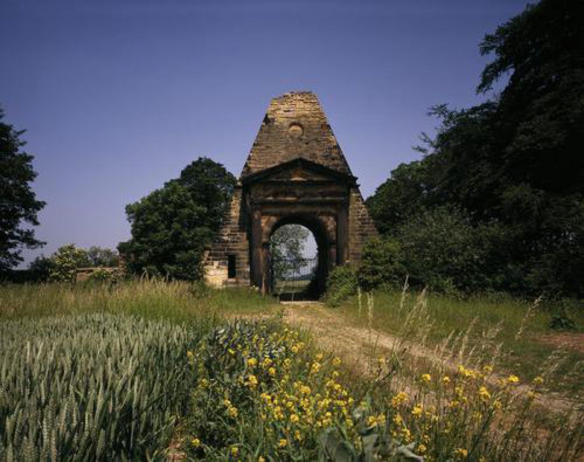
Wragby Lodge is situated on the north side of the A638 and consists of paired lodges (listed grade II) of c 1777 by Robert Adam (1728-92). The present principal entrance is situated c 70m to the west of Wragby Lodge and was formed during the late C20. Obelisk Lodge (listed grade II*) is at the north end of the site and was the entrance from Pontefract via a road which is now (1997) disused. Designed in 1776 by Robert Adam, it is in the form of a narrow pyramid pierced by a central entrance framed by a Tuscan doorway. It is situated at the highest point of the park and views of it are available from various points in the northern part of the park.
Another entrance is situated in Foulby where there is a lodge called Foulby Lodge (listed grade II). The drive, which has been re-routed to the west to avoid running past the lodge which is in use (1997) as a private residence, runs east and north-east, dividing c 500m north of the house. One branch leads north to a caravan site in Top Park Wood and the other swings west and joins with the drive leading south to the house from Obelisk Lodge. An entrance with a mid C19 lodge (listed grade II) leads to the house via the home farm and lies c 100m west of Wragby Lodge.
PRINCIPAL BUILDING
Nostell Priory (listed grade I) is thought to have been designed c 1730 by Colonel James Moyser (guidebook 1990) and based on Palladio's Villa Mocenigo. The erection of the building was supervised by James Paine from 1736. Robert Adam was commissioned to finish the interior of the house in 1765, and he also added the family wing at the north-east corner of the house 1779-80. Some 60m south-east of the house there is a stable block ranged around a courtyard (listed grade I). The south and west ranges were designed by Robert Adam 1770-6 and the north and east ranges by James Pritchett and Charles Watson of York, 1827(9. The south range has a garden house attached to the outer wall.
Some 350m south-east of the house there is a home farm which consists of a range of buildings including the Monks' Refectory (listed grade II*) with C15 monastic origins, a C17 brewhouse (listed grade II) and a number of early to mid C19 farm and estate buildings (most of them listed grade II).
GARDENS AND PLEASURE GROUNDS
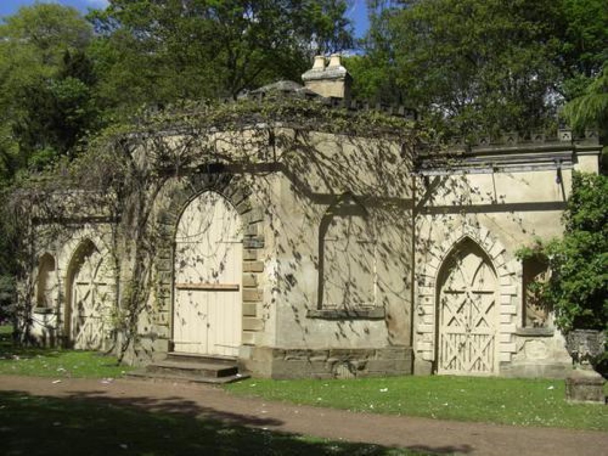
Immediately south of the garden house, which is attached to the south wall of the stables, there is a formal garden in an area defined on the east side by the west wall of the kitchen gardens, the park wall to the south and a fence attached to the south-west side of the stables which runs south to the park wall. An ornate wrought-iron gate in this fence (listed grade II) is probably of late C18 or early C19 date and resembles the listed gates north of the house. Some 20m south of the garden house there is a circular pond (listed grade II), which is not shown on the 1919 OS map. The area has been laid out as a rose garden, probably in the C20, and it is divided into two areas by a low wall which runs across the garden c 40m south of the garden house. The 1919 and earlier OS maps show it with a system of paths and scattered trees.
Pleasure grounds lie to the north, south and west of the house on each side of a lake called Middle Lake which is overlooked by the house and situated c 100m west of the west front. An informal lawn lies between the house and a steep scarp dropping down to the Lake and to the south of this there is woodland with paths leading through it, much as shown on the 1st edition OS map surveyed 1849-51. Some 20m north of the house a wrought-iron fence with two decorative late C18 or early C19 gates (listed grade II) divides the lawns from woodland. Paths lead north to the head of the Lake which has a dam separating it from Lower Lake, to the north. The lakes are mentioned in medieval monastic charters, but the dam may have been created by Stephen Switzer (1682-1745) who shows it on a plan of 'improvements made and to be made' at Nostell of c 1732. Switzer may also have modified the lake outlines. There are views south-westwards over Middle Lake to Nostell Bridge carrying the A638 which was designed by George Savile in 1761 (listed grade II*) and divides Middle Lake from Upper Lake in the parkland to the west.
A path leads over the dam at the north end of Middle Lake and then turns south along the west side of the Lake along a causeway between the Lake and low-lying land to the west. Beyond, the land rises with areas of woodland and rhododendrons with paths leading through them. The path running alongside the Lake gives views of the house over the water and turns at the edge of the garden to run north-west to a stone gothick archway (listed grade II) probably of late C18 date and situated c 250m west of the house. This leads into a disused quarry which was converted into a menagerie in the later C18 and provided with the gothick Menagerie House (listed grade II) mentioned in Robert Adam's correspondence of 1776 which suggests that he modified an existing structure which was probably designed by James Paine. Estate papers of 1797 record payments to a 'menagery man and woman' who probably looked after the animals. South of the Menagerie House and c 300m west of the house there is an earth mound of unknown origin.
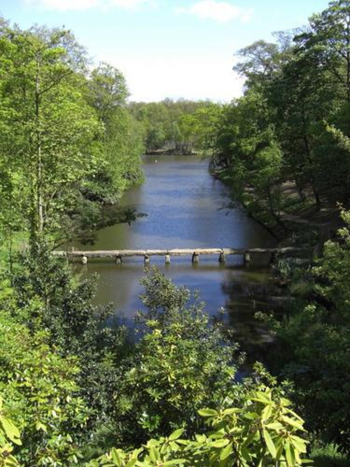
A band of woodland north of the Menagerie separates the pleasure grounds from the park and extends north-eastwards around the north side of Lower Lake, which is connected to Middle Lake by a weir beneath the dam. Paths lead around Lower Lake which has a basin at its eastern end, c 450m north-east of the house, which is divided from the Lake by a bridge which carries the north drive from Obelisk Lodge. A boathouse lies on the south side of the basin (basin, bridge and boathouse are all C18 and listed grade II). Switzer's plan shows Lower Lake further to the east connected with a serpentine canal running west across the park. A county map of 1771 shows the Lake in approximately this position, but it appears in its present form on the 1849-51 OS map.
PARK
Parkland is situated to the north, north-west and east of the house. The walled oval core of the park conforms with the extent of parkland shown on Switzer's c 1732 plan. In addition to this, to the south-west, Upper Lake lies on the south side of the A638 outside the park wall. The Lake is sheltered by woodland on the south and west sides, and it is shown in an early C19 view (Sheeran 1990) with Nostell Bridge and house beyond.
In the south-west corner of the park, immediately east of Foulby, there is an area used as commercial market gardens. North of this, Foulby Park is under arable cultivation. In the north-west corner of the site a caravan park is situated in Top Park Wood and Obelisk Park and Mill Piece to the north and north-east are also under arable cultivation.
East of the house there is open parkland and beyond this, c 300m to the east, there is an avenue which is shown on Switzer's plan, as is a ha-ha c 800m east of the house, which is bowed outwards and connected on each side with the park wall. Beyond the ha-ha the avenue is continued. This is not shown on Switzer's plan and the land was probably added in the late C18. A scheme for the park was drawn up in 1731 by Joseph Perfect (ibid) but there is no evidence that it was executed.
KITCHEN GARDEN
The kitchen gardens are situated between the home farm and the south-east corner of the stables. The north wall, which is attached to the stables, is of stone with an inner brick lining and there is an entrance at the north-east end. This area is divided from a garden to the south by a wall running at an angle so that the gardens have trapezoid forms. The south garden has the remains of glasshouses within it.
OTHER LAND
The church of St Michael and Our Lady (C16, listed grade I) is situated in a walled churchyard c 420m south-east of the house and reached via the drive leading north from Wragby Lodge. The church is the parish church for Wragby and the churchyard contains a number of listed monuments.
REFERENCES
F O Morris, A Series of Picturesque Views 5, (1866-80), pl 63
Country Life, 111 (16 May 1952), pp 1492-5; (23 May 1952), pp 1572-5; (30 May 1952), pp 1652-5
N Pevsner, The Buildings of England: Yorkshire The West Riding (1967), pp 380-2
K Lemmon, The Gardens of Britain 5, (1978), pp 183-6
P Leach, James Paine (1988), pp 20-1
Nostell Priory, guidebook, (National Trust 1990)
G Sheeran, Landscape Gardens in West Yorkshire 1680-1880 (1990), pp 34-7, 70-1, 91
Maps
S. Switzer, Improvements Made and to be Made at Nostell Park, c 1732 [reproduced in Sheeran 1990]
T Jefferys, County Map, 1771
OS 6" to 1 mile: 1st edition surveyed 1849-51; 2nd edition published 1893
OS 25" to 1 mile: 2nd edition published 1919; 1932 edition
Description written: January 1998
Amended: March 1999
Edited: November 1999
- Visitor Access, Directions & Contacts
Telephone
0844 800 1895Website
http://www.nationaltrust.org.ukAccess contact details
The privately-owned parkland is open all year. The house and grounds, owned by the National Trust, are open at particular times. For details see: http://www.nationaltrust.org.u...
Directions
Arriva buses run from Wakefield and the nearest train station is at Fitzwilliam, 1.5 miles away.
Owners
The National Trust
Heelis, Kemble Drive, Swindon, SN2 2NA
- History
The following is from the Register of Parks and Gardens of Special Historic Interest. For the most up-to-date Register entry, please visit the The National Heritage List for England (NHLE):
www.historicengland.org.uk/listing/the-list
HISTORIC DEVELOPMENT
A priory was founded on the site during the 12th century and some of its buildings were converted to a house following the Dissolution. Ownership passed through several hands until it was acquired by the Winn family in 1650. In 1729 the fourth baronet, Sir Rowland Winn, decided to abandon the monastic buildings, but ruins were still visible in 1765. No visible remains of the priory survive today apart from a building called the Monks' Refectory which has been incorporated into the home farm (see below). The park remains (1997) in private ownership and the house and gardens belong to the National Trust (1997) which received them as a gift from the Winn family in 1953.
- Associated People
- Features & Designations
Designations
The National Heritage List for England: Register of Parks and Gardens
- Reference: GD2231
- Grade: II*
Features
- House (featured building)
- Description: The house was built for Sir Rowland Winn, 4th Baronet by James Paine. Robert Adam completed the state rooms at a later date.
- Earliest Date:
- Latest Date:
- Lake
- Tree Avenue
- Description: A magnolia avenue
- Key Information
Type
Park
Purpose
Ornamental
Principal Building
Domestic / Residential
Survival
Extant
Hectares
120
Open to the public
Yes
Electoral Ward
Crofton, Ryhill and Walton
- References
References
- {English Heritage Register of Parks and Gardens of Special Historic Interest}, (Swindon: English Heritage, 2008) [on CD-ROM] Historic England Register of Parks and Gardens of Special Historic Interest
- Sheeran, G. {Landscape Gardens of West Yorkshire 1680-1880} (Wakefield: Wakefield Historical Publications, 1990), pp. 34-7, 70-1 and 91 Landscape Gardens in West Yorkshire 1680-1880
- Pevsner, N., {The Buildings of England: Yorkshire The West Riding} (Harmondsworth: Penguin Books, 2nd edition 1967), pp. 380-2 The Buildings of England: Yorkshire The West Riding
- Lemmon, K., {The Gardens of Britain 5: Yorkshire and Humberside} (London: Batsford, 1978), pp. 183-6 The Gardens of Britain 5: Yorkshire and Humberside
- Janette Ray Associates {Nostell Priory Historic Landscape Management Plan} (2000) Nostell Priory Historic Landscape Management Plan
- Related Documents