Introduction
Kingston Cemetery is the largest of Portsmouth's three cemeteries. It opened in 1856 and was subsequently extended several times up until 1910. The layout is formal and features tree-lined avenues. The Neo-gothic style twin chapels remain, as do two lodges, one of red brick and another of flint and Portland rubble stone.
Terrain
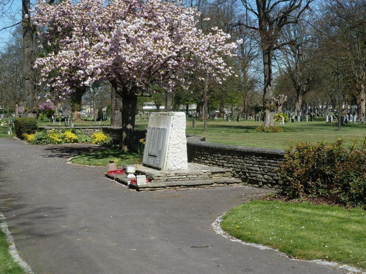
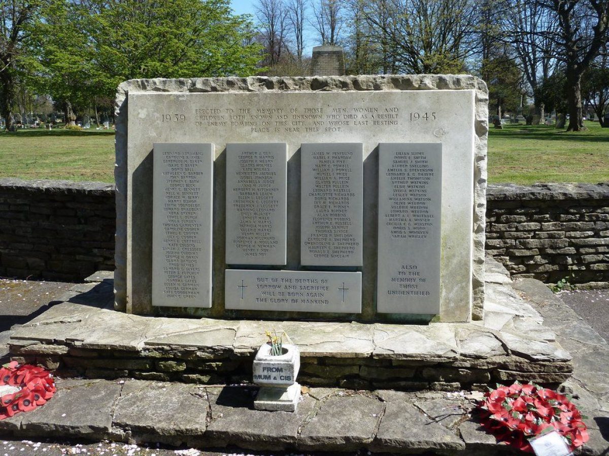
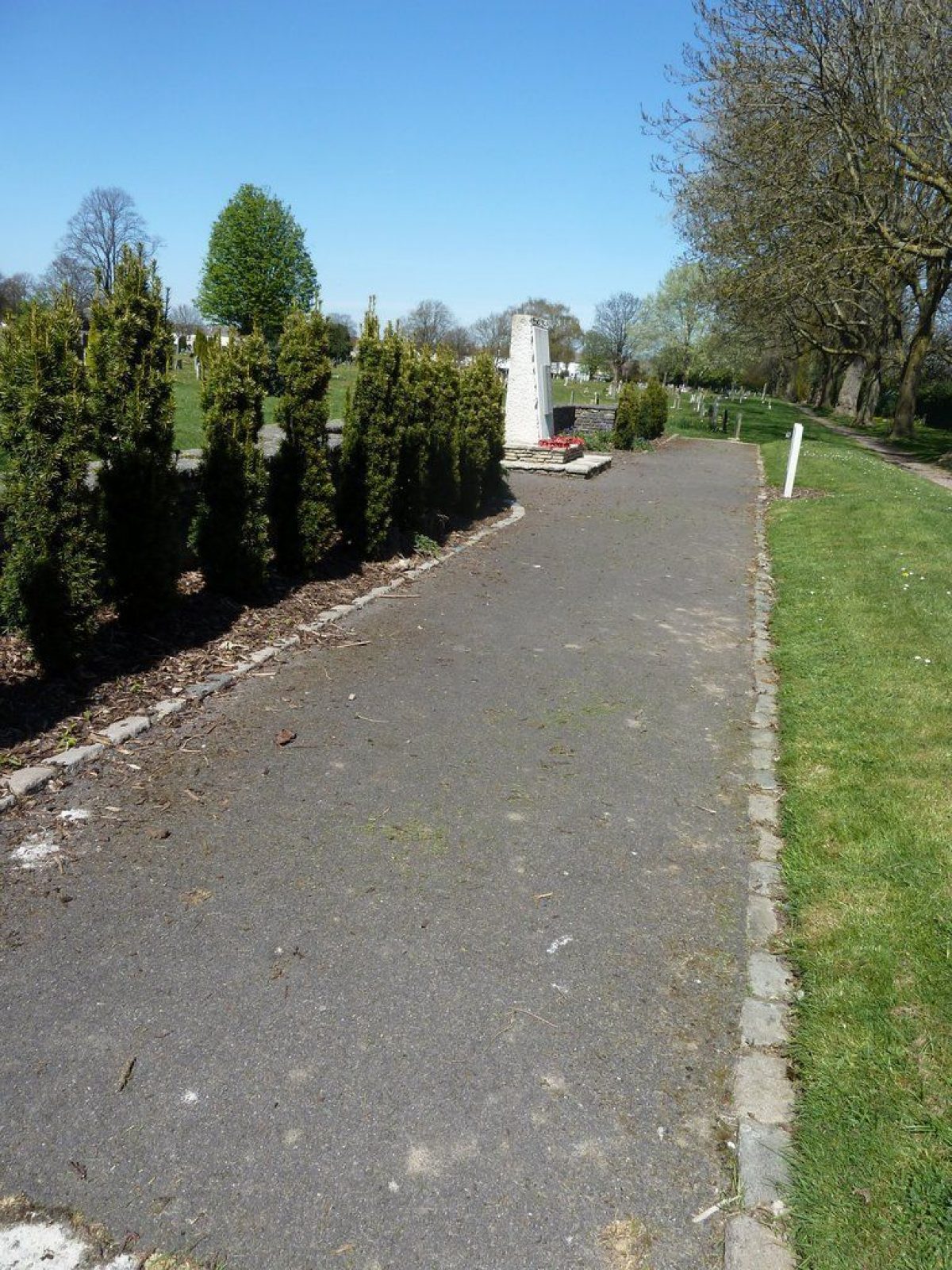
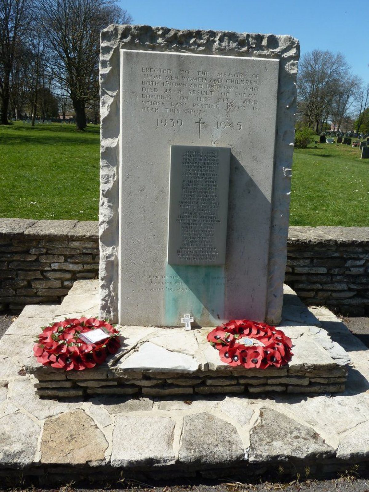
LevelTwo small memorial gardens are dedicated to those killed in WWII bombing of Portsmouth, both known and unknown, on opposite sides of the cemetery on the central drive which is lined with limes. Each small garden has the memorial stone at the centre and borders of about 25 metres on each side. Planting is low maintenance with one border being different euonymous (garden 1) and the other fastigate yews, symmetrically spaced (garden 2). The gardens are reasonably well maintained and lie outside the designated area.
Detailed description contributed by Hampshire Gardens Trust 16/12/2015
The following is from the Register of Parks and Gardens of Special Historic Interest. For the most up-to-date Register entry, please visit the The National Heritage List for England (NHLE):
www.historicengland.org.uk/listing/the-list
A Burial Board cemetery with buildings designed by the architect George Rake and grounds laid out under the supervision of the Board surveyor Charles B Smith, which opened at the beginning of January 1856.
SITE DESCRIPTION
LOCATION, AREA, BOUNDARIES, LANDFORM, SETTING
Kingston cemetery is located on the east side of Portsmouth city. It occupies c 20ha of level ground, bordered to the east by a red brick wall alongside the main London railway line, to the north by a line of mature limes marking the boundary with later cemetery extensions, to the south by a low flint wall topped with railings along St Mary's Road and to the west by the gardens of private housing divided from the cemetery partly by a red brick wall and partly by fencing and hedges. The location and land form preclude any significant views into or out of the site.
ENTRANCES AND APPROACHES
The cemetery can be entered either from New Road to the north or from St Mary's Road to the south. Vehicular access is now (2003) restricted to the St Mary's Road entrance through a lych gate (listed grade II) with iron gates built of flint, grey Portland rubble stone and stone dressings under a slate roof. At its centre is a large entrance with a stone pointed arch, flanked by two pairs of moulded columns attached to recessed covered pedestrian gateways. It was designed by George Rake and erected when the cemetery was first opened. Inside the gateway, to the west, is a small building of matching materials and style, probably used as a place to receive the bodies of the dead, while to the east of the entrance stands the Lodge, again in matching style and materials. The drive runs north for c 70m to a circular turning area with central fountain basin which divides the twin chapels.
Outside the area here registered is a second entrance at the northern end of the cemetery which is also marked by a lych gate, with a central vehicular arch flanked by two pedestrian gateways. It is built of the same materials as the south gate but in a more ornate and grand style with more carving to the stonework and leaded roofs surmounted by delicate ironwork decoration. Inside the gate, to the east, stands a red brick lodge with stone dressings and a slate roof. The work was completed in 1890-91 by the same firm of architects that designed the southern entrance, although by this time they were known as Cogswell and Rake. The drive from the north gate extends south through the centre of the cemetery to join up with the south drive.
PRINCIPAL BUILDING
There are several buildings within Kingston Cemetery, the principal ones being the twin chapels (listed grade II) which stand close to the St Mary's Road entrance. The identical buildings face each other and are constructed of flint with stone dressings under slate roofs in the Neo-gothic style. The west chapel is now used as a store while that to the east is still used for services. The buildings were designed and erected by George Rake in the mid-1850s.
CEMETERY GROUNDS
On entering the cemetery from the south end, the first section is laid in a symmetrical pattern of straight paths on either side of the central drive. There are several large trees particularly along the boundaries and some mature holm oak and holly. Just inside the south gate, to the west, stands a small granite monolith (listed grade II) erected in 1878 as a memorial to those killed on board the HMS Thunderer, while the HMS Racer memorial (listed grade II) stands beside the western chapel.
The central drive, which contains memorials to both World Wars, is lined along the entire length of the cemetery with limes while several of the cross paths are marked by rows of lime pollards. The central avenue trees are at their most mature at the southern end of the drive, within the registered area, suggesting they were planted when the cemetery was first laid out, while the remainder (outside the registered area) are of a similar but smaller size, relating to the building of the north entrance in c1890. The dates on the gravestone flanking the drive confirm that only a small strip of land on either side of the central thoroughfare was initially used, with the remainder of the land being added over time during the early-C20.
To the north of the twin chapels the second section of cemetery ground also has a symmetrical layout on either side of the central path, here laid with circles and curved lines in marked contrast to the southern section. Both these areas survive as they were laid out with no change from the 1860 OS map onwards. A row of mature trees crosses the cemetery on the northern edge of this section, marking the extent of the original area opened in 1854 and the northern boundary of the area here registered.
Outside the registered area, up to the boundary with New Road, a grid layout is adopted. Close to the New Road boundary, on the west side of the entrance arch, is an area enclosed by hedges which houses the Jewish section. Here a yellow and red brick Prayer House was erected at the beginning of the C20 in the north-west corner of the plot.
REFERENCES
Gates W H, Records of the Corporation 1835-1927 (1928) p230
Phillips R, Burial administration 1820-1900 (unpublished dissertation 1979) Portsmouth City Records Office
Webb J, Quail S, Haskell P and Riley R, The Spirit of Portsmouth, A History (1989)
Maps
Sketch map included in Exhibit Book 15 (1854) Hampshire Record Office 21M65/C4/17
OS 6" to 1 mile edition of 1911
OS 25" to 1 mile first edition published 1860; second edition published 1867; edition of 1874; edition of 1898; edition of 1933
Archive items
Portsea Parish Vestry Minute Books (Portsmouth City Record Office CHU3/2A/5)
Exhibit Book No 15 (Hampshire Record Office 21M65/C4/17) 1854-1862
REASONS FOR DESIGNATION
Kingston Cemetery is designated at Grade II for the following principal reasons:
* Kingston Cemetery is a High Victorian cemetery (1856) laid out for a Burial Board.
* The cemetery has a strong geometrical plan executed by Charles Smith, Surveyor to the Portsea Burial Board, with associated structures designed by George Rake.
* The layout of the cemetery, including its associated structures and original planting survives intact.
* The cemetery contains a good collection of C19 and early-C20 funerary monuments, many of which reflect the Naval heritage of Portsmouth.
* The cemetery contains significant memorials to HMS Thunderer (1878) and HMS Racer.
Description written: January 2003
Edited: July 2003
- Visitor Access, Directions & Contacts
Access contact details
Open daily from 9.00am until dusk. For details see: https://www.portsmouth.gov.uk/ext/community-and-environment/community/portsmouth-cemeteries.aspx
Owners
Portsmouth City Council
Civic Offices, Guildhall Square, Portsmouth, PO1 2BG
- History
Both gardens are dedicated to local people who died in the bombing in Portsmouth in World War 2. Unusually, they both seem to commemorate the same thing.
There are no other designed gardens in this cemetery which has been in use since 1856.
Detailed history contributed by Hampshire Gardens Trust 16/12/2015
The following is from the Register of Parks and Gardens of Special Historic Interest. For the most up-to-date Register entry, please visit the The National Heritage List for England (NHLE):
www.historicengland.org.uk/listing/the-list
HISTORIC DEVELOPMENT
The city of Portsmouth suffered a cholera epidemic during 1849 which caused the Borough Council to appoint a committee charged with considering the need for a new cemetery in the Borough. The decision was deferred, however, pending the expected legislation on the subject and it wasn't until the passing of the Burial Board Act in 1854 that a cemetery committee for Portsea parish was appointed. It met in February 1854 to consider suitable plots of land on which to establish the new cemetery. By September of that year a site had been found off St Mary's Lane which was subsequently purchased. The architect George Rake was commissioned to design chapels and lodges while the layout of the ground in a formal style was carried out under the supervision of the Portsea Burial Board surveyor Charles Smith. A dispute over the suitability of Rake's designs for the chapels held up the completion of the cemetery which was eventually consecrated and opened for internments on the 1 January 1856, although the Board minutes record that planting of trees and shrubs continued into 1856. By 1866 the cemetery was full and an extension with a series of rectangular plots lined with avenues of trees was created to the north, on land the Board had purchased in 1854 for this purpose. A further extension took place in 1878 and then in 1889 the cemetery was almost doubled in size when land was purchased to the north of the existing site. The architects Rake and Cogswell were commissioned to design a new lodge and entrance gateway which was erected and opened in 1891. It was connected to the original part of the cemetery by a central tree lined avenue but the whole area was not completely laid out until 1910. In 1893 the Jewish community were allotted an area of ground in the new extension and in 1900 they erected a Prayer Room in the corner of their plot, close to the new north boundary. The cemetery reached its full extent by 1910 and was subsequently surrounded by housing development. It remains an active cemetery in the care and management of the City Council.
Period
- Post Medieval (1540 to 1901)
- Victorian (1837-1901)
- Features & Designations
Designations
The National Heritage List for England: Register of Parks and Gardens
- Reference: GD5274
- Grade: II
Features
- Chapel (featured building)
- Description: The identical twin chapels face each other and are constructed of flint with stone dressings under slate roofs in the Neo-gothic style. The west chapel is now used as a store while that to the east is still used for services. The buildings were designed and erected by George Rake in the mid-1850s.
- Earliest Date:
- Latest Date:
- Boundary Wall
- Description: The cemetery is bordered to the east by a red brick wall alongside the main London railway line.
- Tree Feature
- Description: A line of mature limes marking the boundary with later cemetery extensions.
- Gateway
- Description: The St Mary's Road entrance is through a lych gate (listed grade II) with iron gates built of flint, grey Portland rubble stone and stone dressings under a slate roof.
- Building
- Description: Inside the gateway, to the west, is a small building of matching materials and style, probably used as a place to receive the bodies of the dead.
- Gate Lodge
- Description: The Lodge, in flint and Portland rubble stone.
- Fountain
- Description: A circular turning area with central fountain basin.
- Entrance
- Description: A second entrance at the northern end of the cemetery which is also marked by a lych gate. It is built of the same materials as the south gate but in a more ornate and grand style with more carving to the stonework and leaded roofs surmounted by delicate ironwork decoration.
- Earliest Date:
- Latest Date:
- Gate Lodge
- Description: A red brick lodge with stone dressings and a slate roof.
- Earliest Date:
- Latest Date:
- Drive
- Description: The central drive is lined along the entire length of the cemetery with limes.
- Sculpture
- Description: Just inside the south gate, to the west, stands a small granite monolith erected in 1878 as a memorial to those killed on board the HMS Thunderer.
- Earliest Date:
- Latest Date:
- Sculpture
- Description: The HMS Racer memorial stands beside the western chapel.
- War Memorial
- Description: Memorials to both World Wars.
- Avenue
- Description: The central avenue trees are at their most mature at the southern end of the drive.
- Chapel
- Description: A yellow and red brick Prayer House in the Jewish section.
- Earliest Date:
- Latest Date:
- Key Information
Type
Funerary Site
Purpose
Sacred / Ritual / Funerary
Principal Building
Religious Ritual And Funerary
Period
Post Medieval (1540 to 1901)
Survival
Extant
Hectares
20
Open to the public
Yes
- References
References
- {English Heritage Register of Parks and Gardens of Special Historic Interest}, (Swindon: English Heritage, 2008) [on CD-ROM] Historic England Register of Parks and Gardens of Special Historic Interest
Contributors
Hampshire Gardens Trust
Eleanor Waterhouse