Introduction
Ince Blundell Hall features an 18th-century landscape park, further developed in the 19th century, on a medieval site. The park includes shrub and rhododendron borders and a lake.
Terrain
Level, slightly rolling land.www.historicengland.org.uk/listing/the-list
Gardens and a park laid out in two main phases, commencing in about 1760 and completed by 1786. The site retains a good range of associated structures and features, including some very fine late 18th-century park and garden buildings, reflecting the artistic and antiquarian interests of its creator, the dilettante Henry Blundell.
DESCRIPTION
LOCATION, AREA, BOUNDARIES, LANDFORM, SETTING
Ince Blundell Hall is situated c 0.5km south-east of Ince Blundell. The c 80ha park consists of level, slightly rolling land in an area which is predominantly rural and agricultural. The boundary is formed for most of its length by a brick wall with a flat stone coping which runs from the present main entrance on Back-o-th-Town Lane, on the north side of the site, around the east, south and west sides to West Lodge. From that point onwards the north-west and north boundary is formed by fencing along the edge of Moor Lane and Cross Barn Lane , and it returns as a fence along part of Back-o-th-Town Lane. A lane on the north-east side of the Hall was diverted when the site was imparked and was replaced by Park Wall Road. A writ for the enclosure of the highway is dated 1765 (Keyte 1984).
ENTRANCES AND APPROACHES
There are six main entrances to the park. At the north-west tip of the site the present main entrance to the Hall is on Back-o-th-Town Lane, where there are gates and gate piers of red sandstone surmounted by urns. A drive, now disused, leads past a lodge and curves southwards running to the front of the Hall. A second drive runs west of the lodge, then south-west to the church which is attached to the rear of the Hall and to the service wing. The approach divides and continues to a stable block, joining a drive running from West Lodge on the west side of the site. This arrangement is shown on the 2nd edition OS map published 1909 but not on the 1st edition surveyed 1845-6. The former principal entrance to the Hall and park is situated to the south, at the junction of Park Wall Road and Moor Lane. This is called the Lion Gate (listed grade II) and is an ambitious neo-classical composition copied from a painting by Sebastiano Ricci. The drive leads northwards and formerly ran to the Hall, as shown on the large-scale OS map of 1927 and earlier maps. It was diverted in front of the Hall, probably after the estate was sold in the 1960s, and now connects with a drive which runs around the park perimeter. The line of the drive and turning circle in front of the art gallery adjacent to the Hall (see below) is still visible. There are two entrances on the east side of the site, both on Park Wall Road. The northernmost is opposite Carr Side Lane and consists of a pair of rusticated stone gate piers (1770-6, listed grade II). This entrance leads to the perimeter drive and to a late C20 track running south-west through Tower Wood to join the main drive from the Lion Gate. The other entrance, opposite East Lane, consists of a neo-classical archway flanked by pedestrian entrances (1770-6, listed grade II). This seems formerly to have connected with the perimeter drive only but now also leads to a track running west across the park to join with the main drive from the Lion Gate. On the west side of the site West Lodge (mid C19, listed grade II) consists of a gatehouse with a central arched gateway. The line of the drive which leads north-east to the Old Hall and stables is shown on the 1909 OS map. The 1845 OS map shows that at this time it split into two, with one branch leading to a courtyard west of the stable block, and the other branch, to the east of this, leading directly to the Hall between the Old Hall and stable block. This part of the drive has been blocked from the point at which it reached the Old Hall and its line is not discernible in the gardens. An informal entrance on the north side leads south-east off Cross Barn Lane to the former home farm (outside the registered area) and on into the park, running south to the stable block.
PRINCIPAL BUILDING
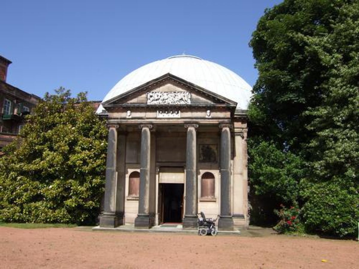
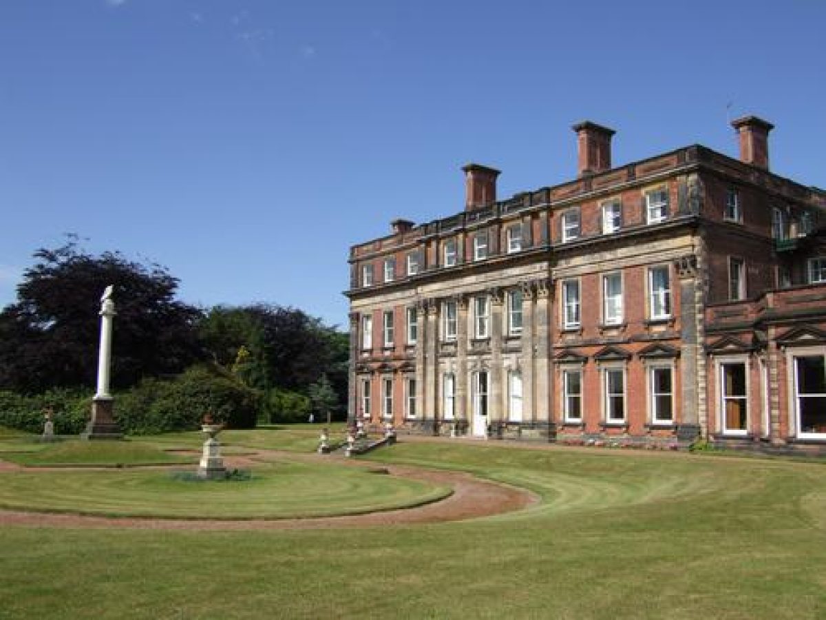
Ince Blundell Hall (listed grade II*) was built 1720-50 for Robert Blundell. It is situated in the north-west part of the site. Attached to the north-east is an art gallery of 1802-10 (listed grade II*) loosely modelled on the Pantheon in Rome and named after it. This was formerly a separate building and was joined to the main house later in the C19. Attached to the north-east end of the Hall's service block is a chapel of 1858 (listed grade II) which serves as a parish church. Some 100m south-west of the Hall lies the now disused Ince Blundell Old Hall (late C16/early C17, listed grade II*). Some 30m south-east of this building is an early C19 stable block (listed grade II).
In the angle formed by the main Hall and the service wing attached to the north there is a circular grassed area planted with a single tree, as shown on the 1845 OS map. At that time this spot was reached by a drive running directly to the Hall from West Lodge, and this arrangement probably originated as a turning circle.
GARDENS AND PLEASURE GROUNDS
The gardens and pleasure grounds consist of woodland to the north and west of the Hall and gardens to the south and east. The principal, south front overlooks a formal garden consisting of a terrace running in front of the house and Pantheon with steps leading down from the central Hall entrance to a sunken oval area. This area has a central mound with an early C19 Tuscan column supporting an eagle (listed grade II) which is shown in this position on the 1845 OS map. A path runs south-east from the south-east side of the sunken area to a point c 60m from the Hall. A ha-ha which runs from a point c 120m north-east of the Hall to a point c 140m south-west of it bows outwards in alignment with the path.
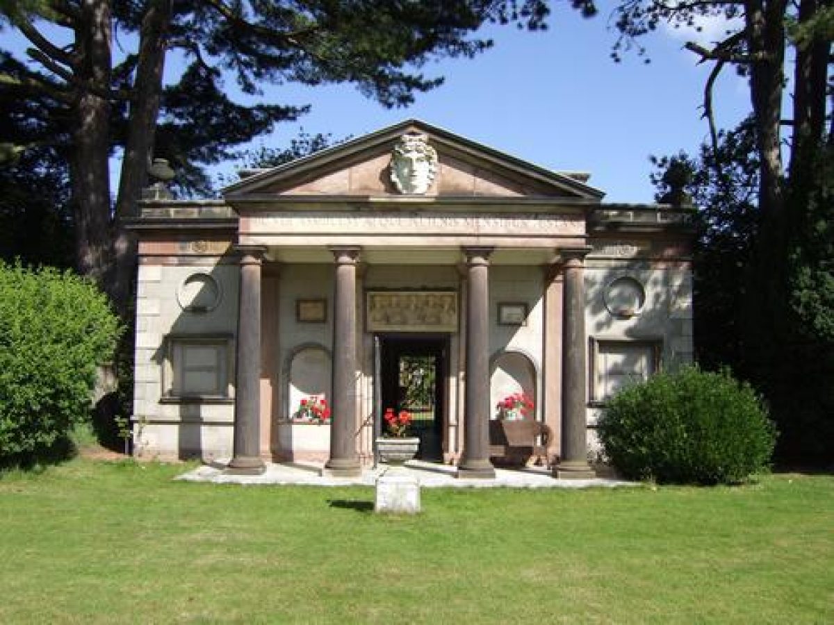
Immediately south and west of the Hall there are informal lawns fringed by trees on the site of a formal garden shown on a map of c 1760. Some 70m to the west, on the edge of the lawn and fronting the walls of a kitchen garden, is a neo-classical garden temple (c 1775, listed grade II*) designed by W Everard of Liverpool as a sculpture gallery. In the frieze is an inscription: 'HIC VER ASSIDUUM ATQUE ALIENIS MENSIBUS AESTAS' (here are perpetual spring and summer in unexpected months), possibly referring to the kitchen garden which could be reached through the temple at one time, or to a glasshouse said to have been affixed to the rear (CL 1958). The gardens south of the Hall were thus articulated around the sculpture galleries which Henry Blundell had chosen to express as detached neo-classical buildings within the grounds rather than incorporating them directly into the Hall.
To the south-west scattered trees partially screen lawns in an area fringed with trees and closed on the north-west side by the rear of the stable block. In a lawn immediately south of this and c 130m south-west of the Hall is a circular sunken area and c 10m south of this is another, irregular, sunken area with paving and a small pond probably constructed in the late C20. This part of the grounds is shown included in the gardens on the 1909 OS map, but the 1845 map shows that a stable courtyard and a drive leading to the Hall partially occupied the area.
Some 100m south of the Hall is the tip of a lake which runs north/south and is c 240m long. It is of sinuous shape and the shores are planted with ornamental shrubs. The lake was created when the park was laid out and is shown on Yates' county map of 1786. Views of the water can be obtained form various points in the gardens, and from the head of the lake its scale is exaggerated by its shape and the surrounding planting.
To the west of the lake and the gardens is an area of ornamental woodland with paths leading through it. This extends to the boundary of the site in its north-west corner and it also extends north of the Hall in an area called Crow Wood. This layout is suggested on the 1786 map; the 1845 OS map shows that parts of it were open land at that time, while the 1909 map shows it with a system of interlocking paths, most of which are no longer visible.
PARK
The park occupies an elliptical area to the south and south-east of the Hall. It consists of level, slightly rolling grassland with some scattered mature trees. There is planting along the perimeter but this is not as dense as is shown on the 1845 OS map. Tower Wood, situated towards the centre of the park, was the site of Blundell Tower (now demolished), a prospect tower or eyecatcher which predated the creation of the park. It is shown in a watercolour of 1790 as a two-storey octagonal structure in Gothick style. The woodland around the site of the tower is shown on the OS map of 1907 but not that of 1845. The most prominent planted feature was a large round clump, called Millhouse Clump, south of the centre of the park. It is shown on the 1845 OS map but only as scattered trees on the 1909 map.
The park has a number of ponds scattered around the perimeter. It is used mainly for grazing and is divided into fields with C20 fencing.
KITCHEN GARDEN
A kitchen garden is situated c 30m west of the Hall. The north-western boundary is marked by a brick wall which continues alongside the drive leading to the stables, and links the Old Hall and stable block. The eastern wall continues for c 50m south of its junction with the northern wall. The south side is bounded by a belt of trees and shrubs on each side of the garden temple. The 1845 OS map shows that the garden was then enclosed on all sides and was elliptical in shape. A round-arched entrance stands on the north-east side and a gated entrance c 30m south of this.
In the garden there are the remains of an apsidal brick structure (listed grade II) which was connected to the garden temple, possibly by a walkway as is suggested on the 1845 OS map. The brick structure has walls attached on each side, running north-east and south-west, with a range of sheds and ancillary buildings attached to the north side. Two glasshouses in the area between this and the northern wall are shown on the 1927 OS map and one of the two surviving glasshouses probably dates from that period.
An additional kitchen garden, called the Peachery, is situated c 250m west of the Hall in woodland. It is of brick with a rectangular plan. It has a late C20 building within it built as a retreat for a religious order.
REFERENCES
The Victoria History of the County of Lancashire 3, (1907), pp 78-85
Country Life, 123 (10 April 1958), pp 756-9; (17 April 1958), pp 816-19; (24 April 1958), pp 876-7
N Pevsner, The Buildings of England: North Lancashire (1969), pp 128-9
V Keyte, Landscape Parks in South West Lancashire, (unpublished MPhil thesis, University of Liverpool 1984), pp 148-50, 295
Maps
Plan of Fields, Roads, and Old Park before inclosed, no date (around 1760), (Lancashire Record Office, DDIn); in Keyte 1984
Pulford, A Map of the Grounds within the first park wall as in the year 1766, with the grounds as they were then outside the wall and all around the House, (Lancashire Record Office, DDIn); in Keyte 1984
W Yates, Map of the County Palatine of Lancaster, 1786
C Greenwood, The County Palatine of Lancaster, 1818
OS 6" to 1 mile: 1st edition surveyed 1845-6; 2nd edition published 1909
OS 25" to 1 mile: 1927 edition
Description written: July 1997
Edited: March 1999
- Visitor Access, Directions & Contacts
Access contact details
Group visits only may be possible by arrangement. Telephone 0151 929 2596. Please see: http://www.ibhnursinghome.com/
Directions
North of Liverpool, off the A565.
Owners
Augustinian Canonesses of the Mercy of Jesus
- History
The following is from the Register of Parks and Gardens of Special Historic Interest. For the most up-to-date Register entry, please visit the The National Heritage List for England (NHLE):
www.historicengland.org.uk/listing/the-list
HISTORIC DEVELOPMENT
The Blundell family held land in the area from the 12th century and the Old Hall at Ince Blundell (listed grade II*) is thought to date from the late 16th century. The park was formed in the years leading up to and following 1766 when a map was prepared showing the grounds within the first park wall and outlining a further area to be imparked. Henry Blundell (around 1730-1810) inherited in 1761 and influenced by his neighbour Charles Towneley of Towneley Hall (see description of this site elsewhere in the Register), he began collecting antique sculpture which he housed in buildings designed for the purpose in grounds close to the new Hall. The Hall and park were sold in the 1960s. The Hall and gardens are now (1997) used by a residential care home and the parkland is farmed. The park supported a herd of deer until the mid-20th century.
Period
- 18th Century (1701 to 1800)
- Late 18th Century (1767 to 1800)
- Associated People
- Features & Designations
Designations
The National Heritage List for England: Register of Parks and Gardens
- Reference: GD1466
- Grade: II*
Features
- Temple
- Sculpture
- Column
- Lawn
- Shrub Border
- Lake
- Hall (featured building)
- Description: A New Hall was built a short distance away from the old one.
- Earliest Date:
- Latest Date:
- Parkland
- Shrub Feature
- Key Information
Type
Park
Purpose
Ornamental
Principal Building
Domestic / Residential
Period
18th Century (1701 to 1800)
Survival
Extant
Hectares
80
Open to the public
Yes
- References
References
- {English Heritage Register of Parks and Gardens of Special Historic Interest}, (Swindon: English Heritage, 2008) [on CD-ROM] Historic England Register of Parks and Gardens of Special Historic Interest
- Farrer, W {Victoria County History: Lancaster, Volume 3} ([n.p.]: [n.pub.], 1907), pp. 78-85 Victoria County History: Lancaster, Volume 3