Introduction
The 17th- and 18th-century formal gardens at Hatton House were once among the most magnificent in Scotland. The house was demolished in the mid-20th century but terraces, garden buildings and gateways survive. The parkland has lost its specimen trees and its mile-long avenue but retains its 18th-century structure of field boundaries.
http://portal.historic-scotland.gov.uk/hes/web/f?p=PORTAL:DESIGNATIONS:0
Type of Site
The remains of late 17th century formal gardens and designed landscape notable for its surviving range of gardens, buildings, terraces and ornamental gateways.
Location and Setting
Hatton House lies some 13km (9 miles) west of Edinburgh City centre, north of the A71 to the east of Kirknewton. The designed landscape is situated on a slight south-east facing incline and above a point where streams from the Dalmahoy Hills meet to form the Gogar Burn, which then flows almost parallel to the A71. It is contiguous on its south-eastern boundary with the Dalmahoy policies, which lie to the south of the A71 (q.v. Inventory, Volume 5, p.49-54). The A71 forms the southern boundary to the site which extends northwards up onto Craw Hill. The historic designed landscape is now surrounded on its east and west sides by agricultural land.
As the majority of the structure planting forming the designed landscape has largely disappeared, internal views within the gardens have largely been lost. The principal view was from the South terrace, looking out over the formal water gardens and wilderness below. Views which do survive are long distance ones, eastwards from the main drive, where Arthur's Seat and Edinburgh provide the focal point. Craw Hill, which once lay within one of the deer parks, rises to 144m (461') from where there are views over the Firth of Forth to Fife. There are also views south to the Pentland Hills.
Today, the designed landscape extends to 36.2ha (89 acres) and the formal gardens below the terrace are now farmland.
The extent of the designed landscape has been reduced by steady erosion of the landscape fabric since the 19th century. Our understanding of the site derives from field evidence alongside surviving architectural features and documentary evidence. In 1793 the gardens 'in five walled areas of unequal sizes, covered fully six acres' and were said to have been surrounded by 'large plantations of at least 800 acres of ground' (OSA, 1793). Originally part of a far larger estate, the 202ha (500 acre) property acquired by Lord Morton in 1890 is said to have represented a quarter of the property sold by the 8th Earl in 1792 (Findlay, 1875).
Landscape Components
Architectural Features
Entrance Gateway ' sited on the A71, this gateway, the 'Great Gateway', is recorded as being moved from a position further to the east, though the exact spot is unknown. Dated 1692, it consists of a high segmental arch faced with pilasters, which have suffered some damage. There are narrower hand-gate arches to the sides. A stone pineapple once decorated the arch but this has disappeared. The back of the gateway records the relocation date 1829. The South Terrace wall with gazebos and bath house dates from c1670, and contains square gazebos with ogee roofs, on two levels. The bath house, c1700, forms a semicircular projection in the centre of the terrace wall. Two Gate Piers, heavily rusticated in alternate courses, bear the Lauderdale arms and are buttressed to the rear. These were built for John, 5th Earl, as part of the grand eastern approach to the 'Lion Gate' and forecourt of Hatton House. The Summerhouse, dated 1704, is classical with a rusticated front arch bearing the Lauderdale arms on the keystone, and flanked by Ionic pilasters. A shallow oblong recess with rounding ceiling, it contains three niches. In the 19th century it was removed to its present position on the south-west of the house, from the bowling green. The Ice House lies near the west pavilion.
Drives and Approaches
The 17th century East Approach bounded by drystone dykes, can still be traced. The removal in the 19th century of the avenue that lined it has detracted greatly from this dramatic and impressive approach. It was carefully sited so as to take advantage of the topography and the long-distance landscape views to be gained. To the east of the original house the land rises gently and, as the brow of the rise is approached, Arthur's Seat comes into view. This is then retained as a focal point of the easternmost section of this long, straight approach.
The South Drive still maintains its 19th century route, although vehicles can no longer use the entrance gateway and the drive around it. The drive enters the site from the West Lodge and curves eastwards across the landscape, skirting the lake to approach the house from the east. Another route to the east of the present drive, entered the site directly to the west of Burnwynd, but this has disappeared. An 18th century estate plan show this to have been on an axis with the avenue that led to Crow Wood, and may have been the site of the gateway later moved in the 19th century.
Parkland
The 'parks' or fields retain their 18th century character and accord with the layout of enclosures at that time, although the parkland planting has not survived.
The Gardens
The original beds or parterres on the terraces have been grassed over and apart from the architectural garden features, other garden remains are skeletal. Most of the area of the northern garden is overrun with bamboo (Arundinaria sp.) and there are some areas enclosed by Leyland cypress hedge (Cupressus leylandii). Sweet chestnut (Catanea sativa), yew (Taxus baccata) and a yew hedge line the northern boundary.
Walled Garden
The 1763 estate plan indicates a wood on the site of the walled garden. The present walled area is divided into four large compartments bounded and divided by good-quality stone walling. The Burnwynd runs through the centre of the garden from east to west. A 19th century range of glasshouses with a conservatory stands in one of the lower gardens, and an earlier peach house in an upper garden. Both are in a very dilapidated state.
- Visitor Access, Directions & Contacts
- History
The following is from the Historic Environment Scotland Gardens and Designed Landscapes Inventory. For the most up-to-date Inventory entry, please visit the Historic Environment Scotland website:
http://portal.historic-scotland.gov.uk/hes/web/f?p=PORTAL:DESIGNATIONS:0
Reason for Inclusion
Good survival of terraces, garden buildings and gateways of major 17th century formal gardens created for Lord Hatton, further developed in the early/mid 18th century by the Earls of Lauderdale. Despite dereliction and tree-loss in the parkland, the policy woodlands, shelterbelts, walls and entrance gateways make a significant contribution to the local landscape character.
Main Phases of Landscape Development
Late 17th century, 18th and 19th centuries.
Site History
The Lauder family was connected with Hatton from the 14th century onwards. Robert Lauder settled his Hatton estate on the Maitlands, following his daughter Elizabeth's marriage to Charles Maitland (later 3rd Earl of Lauderdale) in 1653. Charles Maitland, Lord Hatton (d.1691) was the brother and heir to John, 2nd Earl of Lauderdale, Secretary of State to Charles II (1661-80), created 1st and only Duke of Lauderdale in 1673. Well known as the creator of extensive gardens at Ham House, Surrey, the Duke was the patron of Sir William Bruce whom he commissioned to improve his seat at Thirlestane Castle in 1673 (q.v. Inventory, Volume 5, p.404). Lord Hatton was appointed His Majesty's Deputy Treasurer and called in to assist Lauderdale in his management of Scottish affairs, in which post he was one of the lord commissioners of the Treasury concerning Charles II's restoration of Holyrood House. In 1679 Lord Hatton was appointed Surveyor of all the Royal Palaces and Castles in Scotland.
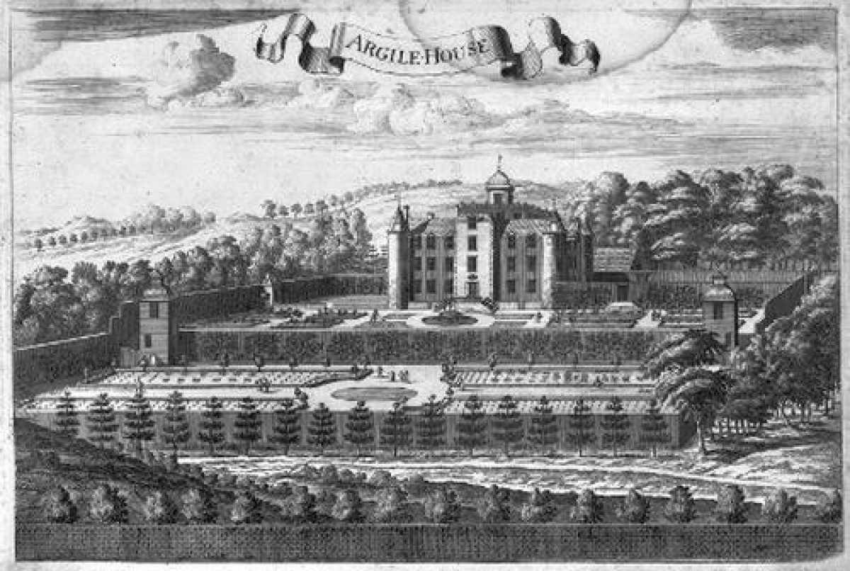
Between 1664 and 1692 he built a new mansion around the existing 15th century tower house, set within extensive formal gardens. Slezer's drawing (c1860) shows Argyle House (as it was mistakenly entitled) with a walled garden to the south, comprising two terraces with a central pond on the upper terrace being ornamented with a pavilion. These pavilions survive. Formal beds are indicated either side of the pool. The lower terrace also had a central pond with formal beds on either side. The walls are shown supporting espalier fruit trees.
Following Lauderdale's death in 1682 Charles Maitland succeeded to the earldom. Sir Robert Sibbald in his Scotia Illustrata (1683) described the 'noble dwelling of Haltoune where are fine gardens and a large park with a high wall about it'. On his death in 1691, Richard Maitland, the 4th Earl, who built the Great Gateway in 1692, succeeded him.
After the death of James VII (d.1701), Richard Maitland took exile in France so that his considerable debts would not encumber the Lauderdale estates. Richard was succeeded by his brother, John, the 5th Earl (d.1710), who added the east front to the house in 1704, linking the north and south wings built by Charles Maitland in 1664. He further ornamented the formal gardens with the Lion Gates, which still stand at the east avenue (1700), the addition of a small summerhouse (dated 1704), and he is possibly the builder of the bath house. This bath house, inserted into the first terrace wall sometime after the date of the Slezer drawing, is still extant. Originally the interior of the bath house was ornamented with statues in niches and the walls and ceilings were decorated with shells. Regrettably, all the interior decoration has disappeared.
Charles (d.1744), the 6th Earl, is known to have made improvements to the gardens and policies of Hatton, and following his death, these may have continued by James, the 8th Earl, created Baron Lauderdale in 1806. Certainly by 1763 (Plans 1763, SRO), the formal gardens had been extended southwards, considerably beyond the gardens portrayed in 1680 (Slezer, 1680). These included a complex of water gardens to the south of the lower terrace, including a cascade fed by diverting and widening the feeder streams which rise in the Dalmahoy Hills to form the Gogar Burn. The formal ponds were amalgamated into one large lake in the 19th century.
To the east of the walled garden was an extensive wilderness with radiating paths. The wider policies included a deer park to the north of the house on hilly ground, with an avenue leading to Craw Hill. Craw Hill itself was laid out with radiating rides which are clearly indicated on Roy's Survey (1747-55). South-east of this deer park lay the Old Deer Park (Plans 1763, SRO). Square parks surround the central core of the designed landscape.
In 1792 the 8th Earl, James, sold the estate to the Trustees of General Scott, and from that time is passed through several hands, with the estate being fragmented and with incremental changes to the landscape. From 1812 to 1815, Francis Jeffrey was the tenant, and the gardens seem to have been much neglected (Country Life, 1911). Captain Davidson took up residence at Hatton in 1820, attempted to restore parts of the house, improved the grounds and thereby incurred enormous debts. The factor appointed by the Commissioners, named by the Court of Sessions to administer the property, cut down many of the trees, including the Great Avenue to the east comprised of oak, beech and lime. In 1870 Lord Morton bought 500 acres, comprising the eastern portion of the estate and included it in the entail of Dalmahoy.
By 1875 the former 'deer parks were sadly curtailed, the fines timber felled, the artificial cascades and ponds except one all drained'. Lord Morton's son, Lord Aberdour, restored the house and the upper terraces. The Whitelaws then bought the estate but it was sold in 1947 to Mr Archie Stevenson. The house was destroyed by fire in 1952 and in 1955 it was demolished. A bungalow was built on the site of Hatton House, but the remnants of the terrace gardens survive.
- Features & Designations
Designations
Historic Environment Scotland An Inventory of Gardens and Designed Landscapes in Scotland
Historic Environment Scotland Listed Building
- Reference: East Avenue gate
- Grade: B
Historic Environment Scotland Listed Building
- Reference: South Gateway
- Grade: A
Historic Environment Scotland Listed Building
- Reference: Terrace wall and gazebos
- Grade: B
Features
- Summerhouse
- Earliest Date:
- Latest Date:
- Icehouse
- Bath House
- Key Information
Type
Estate
Purpose
Ornamental
Survival
Part: standing remains
Hectares
36.2
- References
References
-
Historic Scotland, 'Hatton House', {Gardens and Designed Landscapes},
-
Historic Scotland, 'Hatton House', {Gardens and Designed Landscapes},