Introduction
Gibside has an 18th-century landscape park and woodland.
Terrain
Hilly
The following is from the Register of Parks and Gardens of Special Historic Interest. For the most up-to-date Register entry, please visit The National Heritage List for England (NHLE):
Pleasure grounds laid out and embellished with a range of features by George Bowes during the period 1729 to 1760 with advice from Stephen Switzer who prepared designs in 1731 and 1732.
Location, Area, Boundaries, Landform and Setting
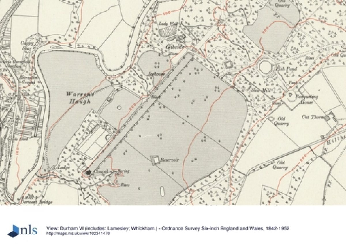
Gibside is situated c 1km east of Rowlands Gill. The c 150 ha site is on land which slopes down to the River Derwent which forms the northern boundary. Leapmill Burn forms the boundary to the west and the fenced edge of West Wood the southern boundary. The north-east boundary is formed by fencing along the edge of Snipes Dene Wood.
Entrances and Approaches
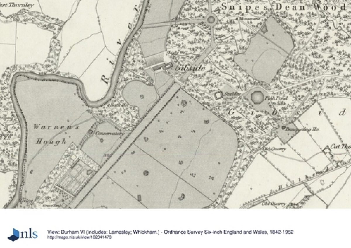
The present (1998) entrance to Gibside is from the B6314 at the bottom of Busty Bank. A drive leads north-eastwards immediately south of a bridge crossing the Derwent. It branches, with one route leading to late C20 car parks in a thinly wooded area immediately north of a building called Chapel Cottage (early C19, listed grade II). The other route, now (1998) disused, leads north and north-east over Warren Haugh to the edge of woodland where there are the scattered remains of C19 gate piers.
An entrance on Fellside Road on the east side of the site is reached from a drive leading north from West Lane, and this now (1998) serves the Banqueting House and estate traffic only. It continues westwards past the Octagon Pond to the Hall. This route joins the main historic approach called the New Coach Way, which was built in the years 1738 to 1740 under the supervision of surveyor William Joyce, who had previously been head gardener. An entrance made in the C19 lay north-east of the site and outside the registered area close to the junction of Fellside Road and Clockburn Lane, entering the site at its easternmost tip. In the C18 the drive ran from Fellside Road, also outside the registered area, to a set of C18 lodges (now demolished) close to the C19 entrance.
Principal Building
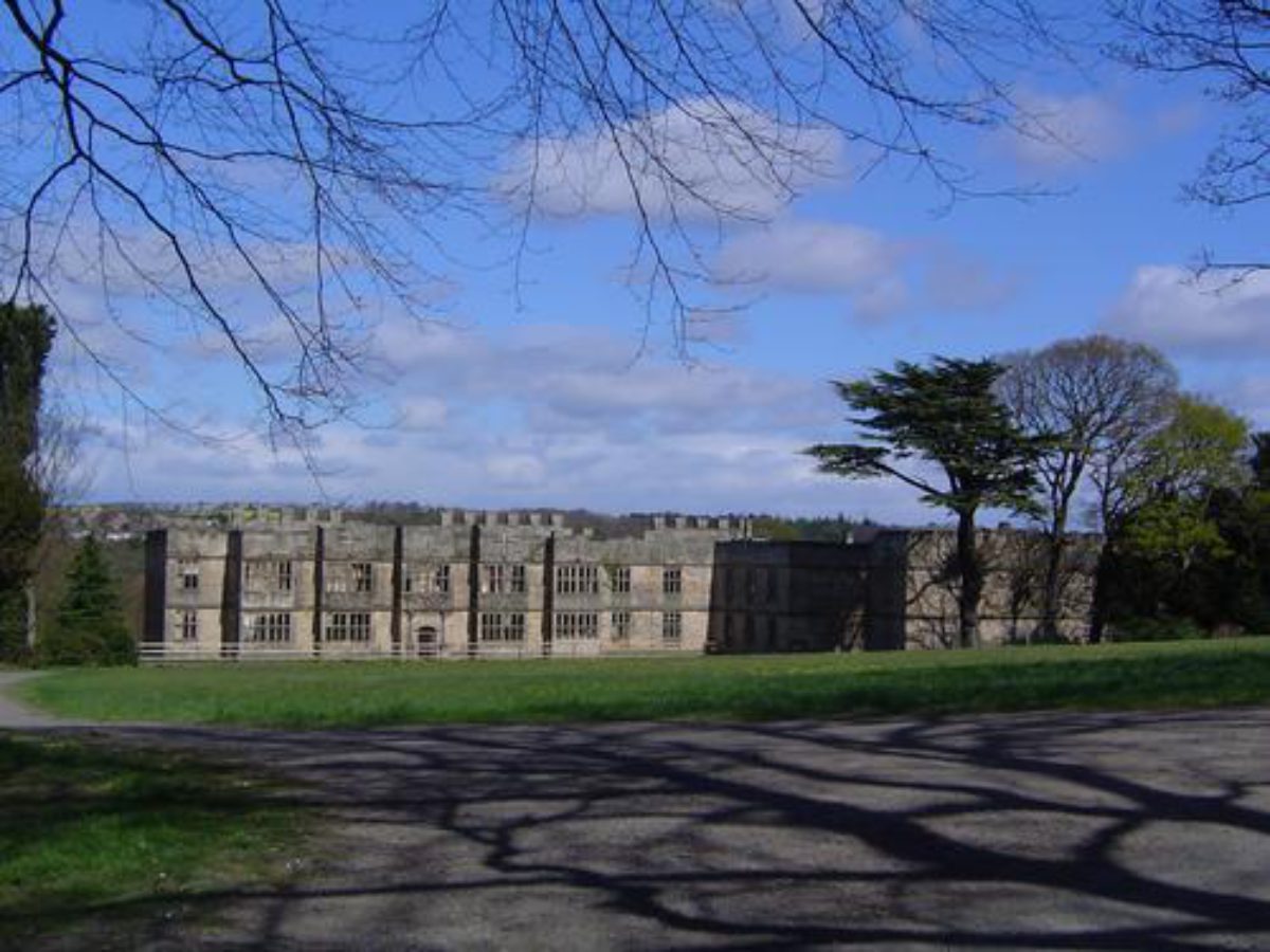
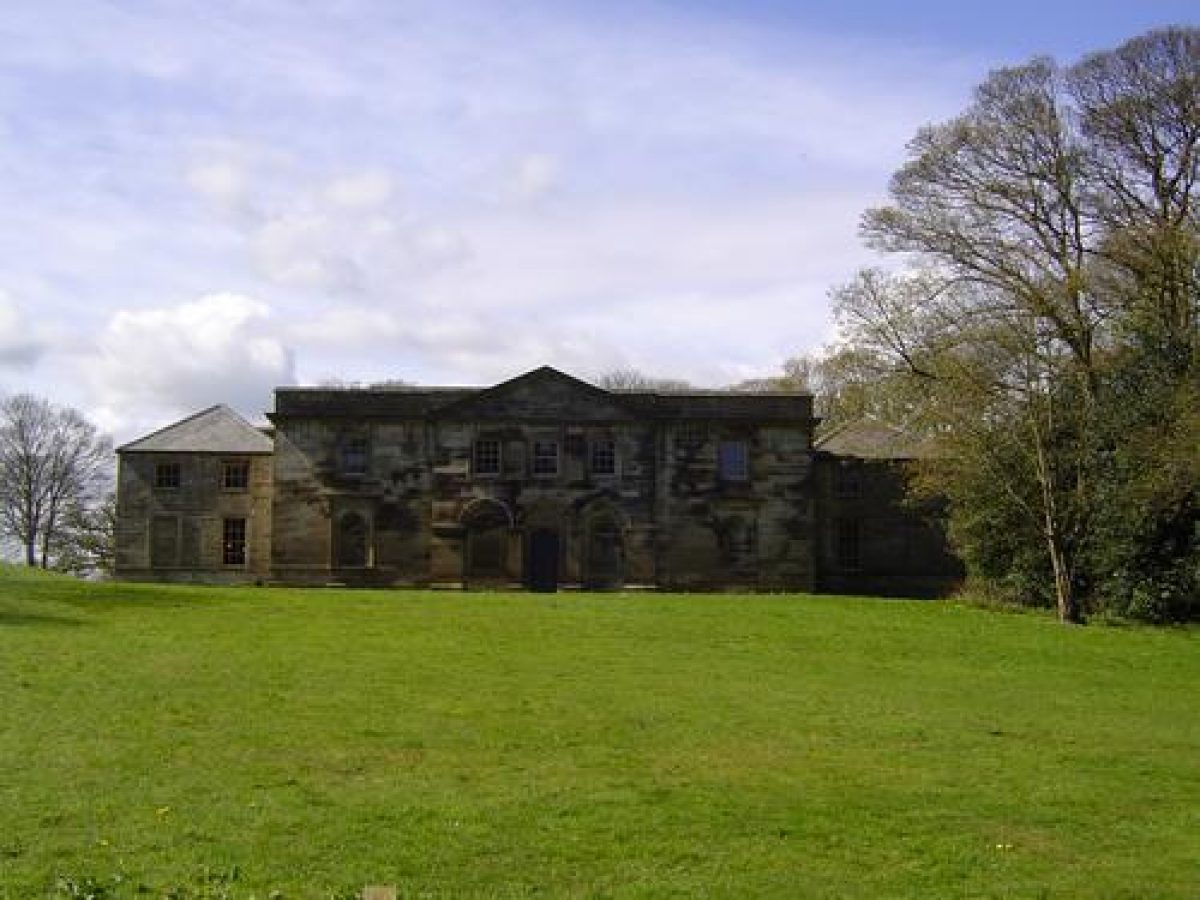
Gibside Hall (listed grade II*) was built 1603-20 for William Blakiston and enlarged in the mid C18 for George Bowes. The building was substantially altered again in 1805 by Alexander Gilkie for the tenth Earl of Strathmore. It fell into disrepair in the early C20 and is currently in ruinous condition (1998).
The Hall is set on the edge of a ramped slope, Parlour Bank, overlooking the Derwent near the centre of the north side of the site and a terrace on the north side of the building gives views over a meadow called Lady Haugh and the river beyond. On the south side of the building there is a grassed clearing surrounded by the remains of a carriage sweep.
Kitchen Garden
The kitchen garden lies c 50 m north-east of the Chapel and consists of a rectangular brick-walled enclosure (listed grade II) with a pond in the south-east corner, as shown on the 1767 map. A garden house is attached to the north wall. There is evidence for late C18 garden outbuildings running eastwards from the north wall and there are footings for an orchid house and for vineries more than 90 m in length in the north side of the enclosure. There are a number of entrances with rusticated stone surrounds, and an entrance in the east wall connects with paths leading from the Orangery. A ruinous stone building at the centre of the outer north wall has a door from the garden and there are views from it over Warren Haugh. This originated as a fruit store and was converted to a summerhouse in the second half of the C19. The garden was constructed 1734-6, replacing one closer to the Hall.
Park
Gibside is a landscape laid out on a monumental scale in which a series of structures and buildings erected for George Bowes form incidents in a largely wooded landscape. These features are interconnected by axial rides and views and form part of an unfolding sequence which can only be appreciated by moving around the site.
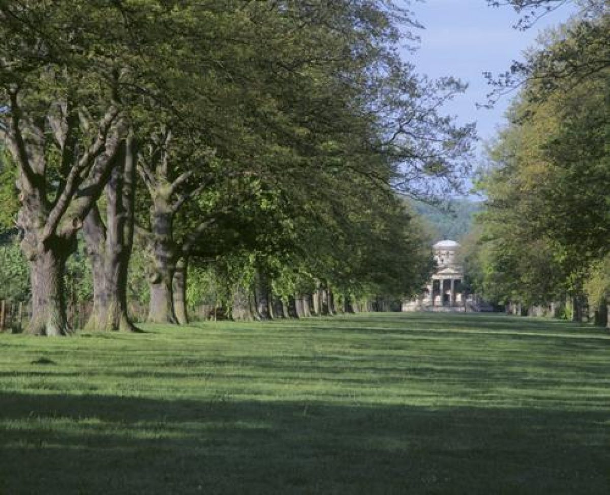
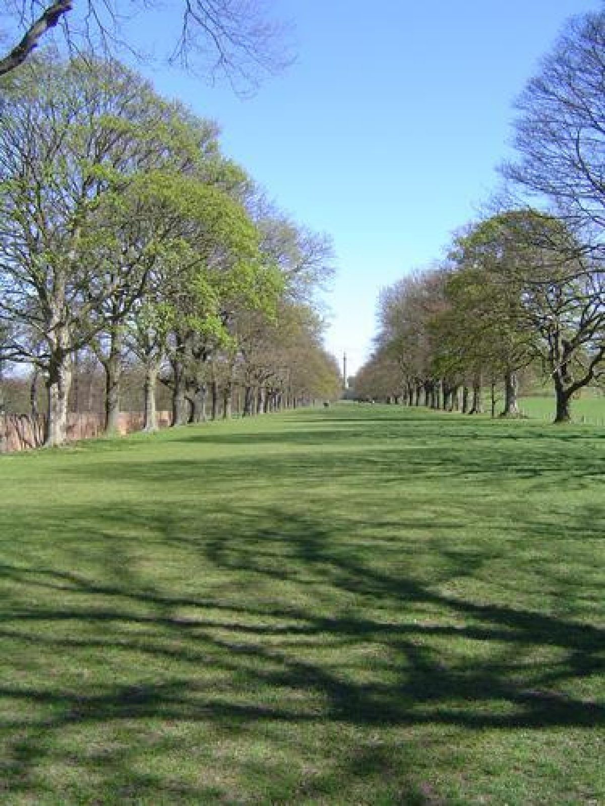
The principal axis is the Grand Walk, a raised terrace c 700 m in length which was laid out 1746-9. It is orientated south-west/north-east and runs approximately parallel to the line of the Derwent. The walk is ramped on the north side and on the south side it is divided from parkland by a ha-ha, with views over open land and woodland on the horizon to the south. It has a mixed avenue of oak, lime and sycamore planted in the C19.
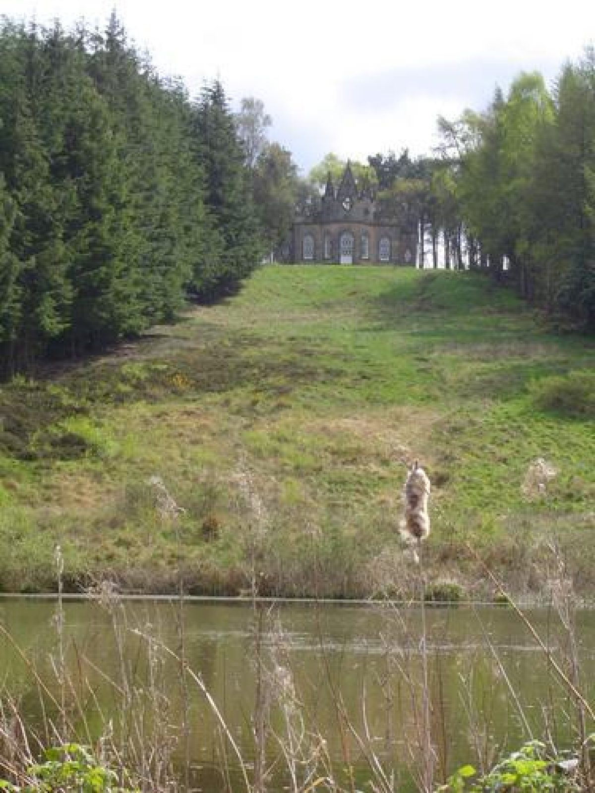
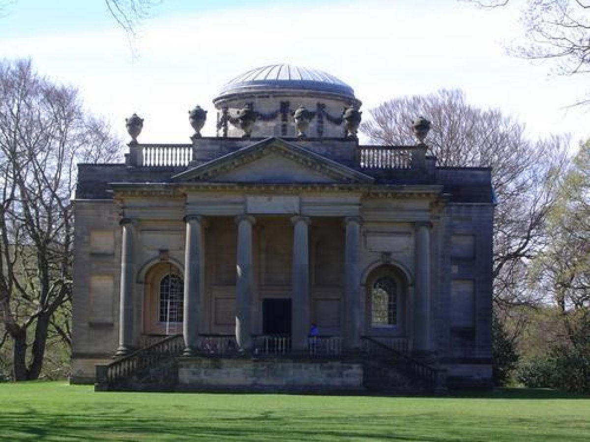
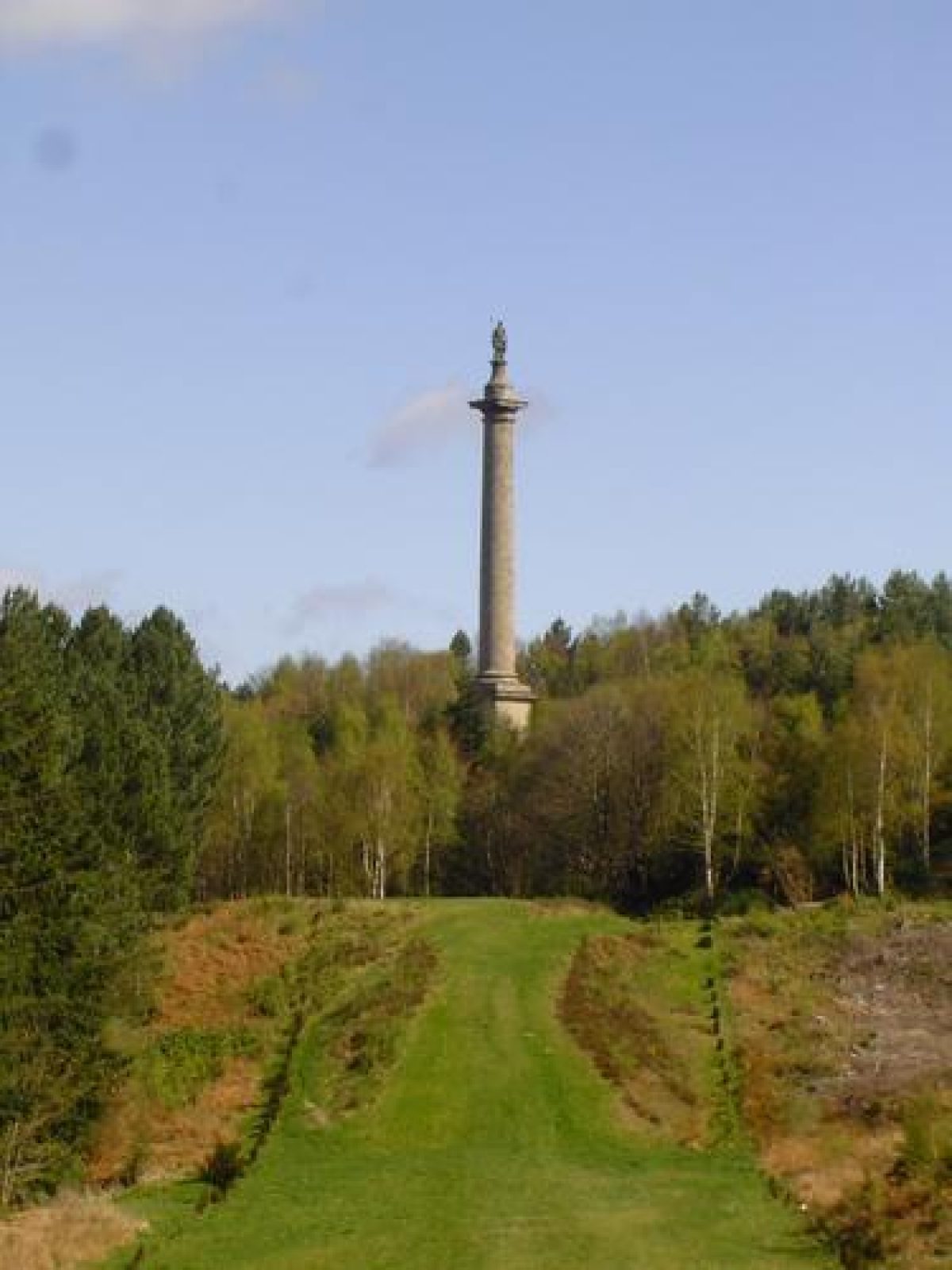
At the south end of the walk is the Chapel (listed grade I) of 1760-9 by James Paine, completed after Bowes' death. The building has been described as 'a perfect example of a Georgian church in the most select Classical style' (Pevsner 1968). Closing the vista is the Monument to Liberty (listed grade I), a Doric column c 50 m in height which was designed by Daniel Garrett and James Paine and is surmounted by a figure representing Liberty by Christopher Richardson. This monument, an overt expression of Bowes' nationalist and Whig sympathies, was built 1750-7 at a cost of just over £1600.
On the north side of Grand Walk, immediately north-east of the kitchen garden, there is a rectangular field with a central circular pond. On its north side is the ruinous Orangery (listed grade II). The building is on the edge of steep drop overlooking Warren Haugh and the Derwent and was built 1771(5 for Bowes' daughter Mary Eleanor, a keen botanist. The enclosure south of the Orangery is marked 'paddock' on the 1767 map. The Green Close, further east, may have been the site of a bowling green mentioned in estate accounts of 1734.
At the north end of the Grand Walk the axis is continued by a sunken way called the Hollow Walk. Paths lead eastwards through woodland to a classical stable block (listed grade II*) of 1746 by Daniel Garrett and continue on to a clearing where there is an axial view terminated at the south end by Daniel Garrett's Banqueting House (1741-4, listed grade I), set at the top of a steep terraced slope. At the base of the slope, below a stepped amphitheatre, there is a raised octagonal pond, designed to be seen from Coach Way and from the terrace on the north side of the Banqueting House. The pond was constructed in 1740-1, possibly in emulation of the octagon lake at Stowe (qv) which Bowes had visited in 1737. The Banqueting House is set on a platform which forms a rectangular bastion with attached ha-ha walls on the south side of the building from which views of rising agricultural land extending to the south can be obtained. From the terrace on the north side there are axial views north-west over the Octagon Pond to a rondpoint at the end of the Hollow Walk, with the Monument to Liberty to the north.
From the Octagon Pond a route leads north-west to the rondpoint at the east end of the Hollow Walk, with views to the Chapel and the Monument on one axis, and to the Banqueting House and the river on the other. A route leads north-west to a small circular pool with views down the slope to the west to the Derwent. The pool is at the base of a steep amphitheatre-like slope, with the Monument at the top. Winding paths lead through woodland to the Monument, which is on a modified spur with a semicircular scoop cut into its outer (western) edge on the west side. From the west side of the column the pool can be seen closely framed by the scooped platform edge, with views beyond to the west through woodland and along a ploughed-down earthwork in Lady Haugh to the Derwent, with rising land beyond.
On the north side of the site serpentine walks from the Hall lead to paths running north-east along the south side of the Derwent. A loop of the river, where the land falls precipitously as steep cliffs, is the site of a bath house which was the first of Bowes' buildings on the site, erected in the period 1733 to 1740. The building, of which only foundations survive, was positioned on an artificial terrace on a bend of the river with views over the water to rising land beyond. The designer of the building is not known, but drawings of 1827 (Wills 1995) suggest that it had close parallels with designs by James Gibbs published in 1728. The interior was decorated by stuccadore Francesco Vassalli. In 1741 three weirs were made in the river below the bath house, and work on building retaining walls along the Gibside banks, some of which survive, began in 1733. The riverside walk overlooks the flood plain and meadows of Warren Haugh and Lady Haugh, and links with serpentine shrubbery walks through woodland west of the Hall. These walks contrast with the grand axial routes of the remainder of the site, having a more intimate character with emphasis on the natural beauty of the riverside.
Park Fields, on the south side of Grand Walk, have clump planting of the mid 1840s. On the south side of the fields a ha-ha runs along the edge of West Wood beside a straight ride along the edge of the woodland. There are other rides through West Wood and in Snipes Dene Wood to the north, some of which are marked on the 1767 map.
Maps
- James Stephenson, Estate map, 1767 (Strathmore papers), (Durham Record Office)
- T Jefferys, County map, surveyed 1768-70
- OS 6" to 1 mile:
- 1st edition surveyed 1857
- 1921 edition
Description written: May 1998; Amended: March 1999
Register Inspector: CEH
Edited: July 2000
- Visitor Access, Directions & Contacts
Telephone
01207 541820Access contact details
The grounds are open daily between 10 and 4 (until 6 in the summer).
- History
The following is from the Register of Parks and Gardens of Special Historic Interest. For the most up-to-date Register entry, please visit the The National Heritage List for England (NHLE):
www.historicengland.org.uk/listing/the-list
HISTORIC DEVELOPMENT
Gibside was owned by the Marley family until the C16 when it passed to the Blakistons through marriage. It remained in the family until 1713 when it passed, again through marriage, to the Bowes family. George Bowes inherited in 1721 and shortly after began laying out the grounds. He sought advice from William Etty (c 1675-1734) who was paid £10 10s in 1727 for plans, but no further payments were made to Etty and it is unlikely his plans were executed. Stephen Switzer (1682-1745) drew up a plan in 1731 and more plans the following year, and he supplied trees for the grounds in 1732. The plans do not survive and the extent to which they influenced the layout of the grounds is unknown. Switzer did not oversee any of the work, which was undertaken by an estate workforce. William Joyce, who was head gardener from 1732 to 1736, was a key figure in the laying out of the site. An estate map of 1767 by James Stephenson shows the executed layout.
The woodland was largely felled during the 1930s, and much of the former wooded area was afforested in the 1950s. A programme of replanting is still in operation (1998). The Chapel was given to the National Trust by the sixteenth Earl of Strathmore in 1974, and most of the woodland was acquired by the Trust in 1993, with areas of farmed parkland following in 1998. The remaining land is in private ownership and the Banqueting House and its precincts are owned by the Landmark Trust (1998).
- Associated People
- Features & Designations
Designations
The National Heritage List for England: Register of Parks and Gardens
- Reference: GD1485
- Grade: I
Site of Special Scientific Interest
Features
- Column
- Description: The column of liberty.
- Chapel
- Description: The palladian chapel.
- Stable Block
- Description: Georgian stables.
- Earliest Date:
- Latest Date:
- Orangery
- Description: The orangery was created in about 1774 for Mary Eleanor Bowes.
- Earliest Date:
- Latest Date:
- Bath House
- Description: A ruinous bath house.
- Walk
- Description: The long walk is tree lined and stretches from the chapel to the column of liberty.
- Summerhouse
- Description: The summerhouse is located on a hill above the Octagon pond.
- Ornamental Pond
- Description: The Octagon pond.
- Ruin
- Description: Gibside Hall (C16, listed grade II*) was built 1603-20 currently in ruinous condition (1998).
- Walled Garden
- Banqueting House
- Description: C18 listed Grade 1
- Ha-ha
- Key Information
Type
Park
Purpose
Ornamental
Survival
Part: standing remains
Hectares
150
Open to the public
Yes
Electoral Ward
Chopwell and Rowlands Gill
- References
References
- {English Heritage Register of Parks and Gardens of Special Historic Interest}, (Swindon: English Heritage, 2008) [on CD-ROM] Historic England Register of Parks and Gardens of Special Historic Interest
- Pevsner, N. and E. Williamson, {The Buildings of England: Country Durham} (London: Yale University Press, 2002), pp. 292-5 The Buildings of England: County Durham
- Leach, P., {James Paine} (London: Zwemmer, 1988), pp. 185-6 James Paine
- National Trust {Gibside Conservation Plan} (2000) Gibside Conservation Plan
- Simpson and Brown {Gibside Conservation and Management Plan} (2013) Gibside Conservation and Management Plan
- (8 February 1952), pp 354-7; (15 February 1952), pp 422-5; 166 (27 December 1979), pp 2460-1 Country Life, 111
- Durham County Council 1980 Streatlam and Gibside: The Bowes and Strathmore families in County Durham,
- P Leach, James Paine (1988), pp 185-6 James Paine
- Tyne and Wear Specialist Conservation Team 1995, pp 14-15 A Guide to the Historic Parks and Gardens of Tyne and Wear,
- 1995 Gibside and the Bowes Family
- (National Trust 1978) Gibside Chapel, guidebook